
Mori Atlas logo
State or regional parkMorden Colliery Historic Provincial Park

Mapping the preserved coal mining remains and historic railway corridors of southern Vancouver Island

Morden Colliery Historic Provincial Park: A Significant Industrial Heritage Site on Vancouver Island

Morden Colliery Historic Provincial Park offers a unique look at the industrial archaeology of British Columbia. This protected area preserves the towering concrete headframe and tipple of the former Pacific Coast Coal Mining Company, standing as a rare landmark from the coal era on Vancouver Island. Through its railway corridors and memorial sites near Nanaimo, the park documents the intersection of human history and coastal forest landscapes, providing a distinct perspective on the region's early twentieth-century development.

industrial heritagecoal mining historyhistoric provincial parkVancouver Islandheadframetipple
Vector-style graphic illustration showing a tall, pointed mountain with a cascading waterfall in the center, flanked by green forests and a river in the foreground.

Morden Colliery Historic Provincial Park

State or regional park

Park overview

Structured park overview, official facts, and landscape profile for Morden Colliery Historic Provincial Park

Morden Colliery Historic Provincial Park park facts, protected area profile, and essential visitor context

Review the core facts for Morden Colliery Historic Provincial Park, including designation, size, terrain, visitor scale, habitats, and operating context in one park-focused overview.

About Morden Colliery Historic Provincial Park

Morden Colliery Historic Provincial Park is a heritage-focused protected area on southern Vancouver Island, designed to preserve a fragment of British Columbia's coal mining past rather than a natural landscape. Located near the east coast of the island within the Regional District of Nanaimo, the park encompasses the remains of the Morden Colliery, including the concrete headframe and tipple that once moved coal from underground shafts to waiting railway cars. Though physically small, the site holds an outsized place in the regional history of coal extraction, mining communities, and industrial transportation.

The park's identity grew out of the operations of the Pacific Coast Coal Mining Company (PCCM), which in 1909 constructed a standard-gauge railway from Fiddick's Junction on the E&N Railway to Boat Harbour to ship coal to vessels. The line later extended to the Fiddick Colliery, but the 1915 drowning deaths of 19 men in the Fiddick mine disaster brought production there to an end. Work in the Morden area had been underway since 1912, and when the Fiddick mine closed, workers were transferred the short distance southeast to develop what became the Morden Colliery. From 1917 onward, Morden became one of PCCM's principal producing sites, with hoisted coal dumped through a chute directly into railway gondola cars.

After financial troubles closed the mine in the early 1920s and intermittent later activity failed to revive it, the surrounding landscape transformed again. The settlement around the mine persisted, serving in subsequent decades as a base for logging and eventually becoming a bedroom community for Nanaimo. Recognition of the site's place in Canada's industrial narrative led to its designation as a National Historic Site and its formal establishment as a provincial historic park in 1972.

In modern times the park functions primarily as a day-use heritage site, with interpretive plaques and a memorial cairn that commemorate both the three men who lost their lives at Morden and the estimated thousand miners who died across Vancouver Island coal operations. A trail along the former railway right-of-way links the park to the broader landscape, including the Nanaimo River corridor and, eventually, Hemer Provincial Park. Ongoing restoration of the headframe, led by the Friends of Morden Mine with significant provincial investment, has positioned the park as a leading example of industrial heritage preservation in Western Canada.

Quick facts and research context for Morden Colliery Historic Provincial Park

Morden Colliery Historic Provincial Park covers about 4 hectares (9.9 acres) on the east side of southern Vancouver Island, in the Regional District of Nanaimo, British Columbia. It is administratively classified as a Historic Provincial Park under BC Parks. The park lies roughly 10 kilometres south of Nanaimo and roughly 102 kilometres by road northwest of Victoria, accessed via BC Highway 19.

The site was established as a provincial historic park on 10 January 1972 after earlier recognition as a National Historic Site. Its core feature is the concrete headframe and tipple associated with the early 20th-century Morden Colliery operated by the Pacific Coast Coal Mining Company. It is now managed cooperatively with the Friends of Morden Mine (FOMM), an organization instrumental in saving and restoring the deteriorating industrial structure.

Protection and recognition

Documented terrestrial protection scope and designation framework details

Morden Colliery Historic Provincial Park Protection Status and Recognition

Terrestrial protection status and administrative designation records define the conservation framework for Morden Colliery Historic Provincial Park. Structured governance details provide transparent context regarding management scope and recognized preservation boundaries.

Protection details

Protection scope
Terrestrial
Park context

Deeper park guide and search-rich context for Morden Colliery Historic Provincial Park

Morden Colliery Historic Provincial Park history, landscape, wildlife, and travel context

Explore Morden Colliery Historic Provincial Park through its history, landscape character, ecosystems, wildlife, conservation priorities, cultural context, and seasonal travel timing in a structured park guide built for atlas discovery and search intent.

Why Morden Colliery Historic Provincial Park stands out

Morden Colliery Historic Provincial Park is best known for preserving the towering concrete headframe and tipple of the early 20th-century Morden Colliery, one of the most intact surviving examples of this kind of mining structure in North America. The site documents a critical chapter in Vancouver Island's coal mining history, from the opening of the Pacific Coast Coal Mining Company operations through the Fiddick mine disaster and the shift of production to Morden. The park also stands out for its rare industrial heritage value outside of the Muddy, Illinois example. After years of deterioration, the headframe received a major multi-year restoration effort supported by provincial funding and led by a community society, making the site an important case study in grassroots preservation of industrial structures.
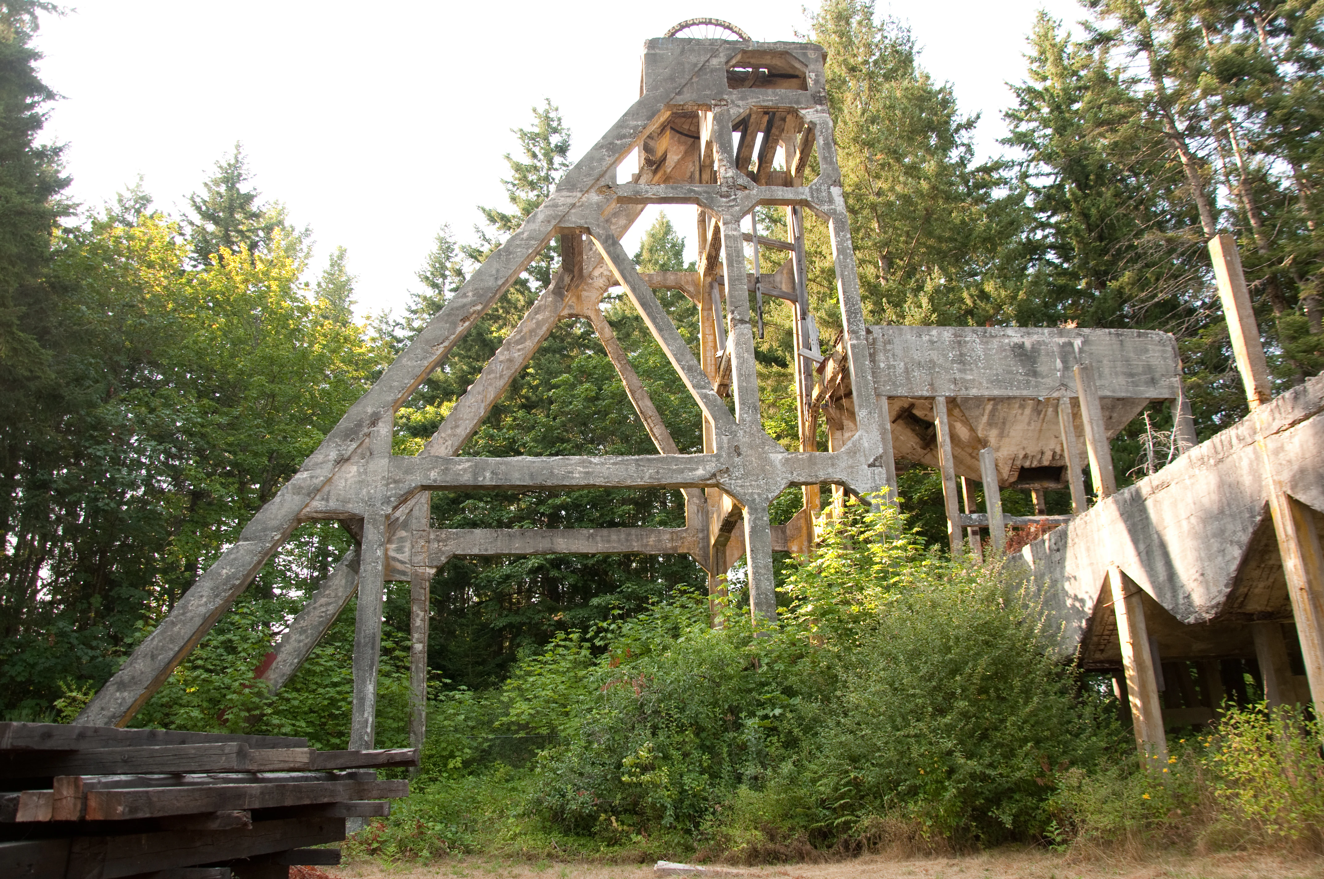
The concrete structural skeleton of a large, weathered industrial headframe from the Morden Colliery, surrounded by dense evergreen trees.
The concrete headframe remains at the Morden Colliery historic site.

Morden Colliery Historic Provincial Park history and protected-area timeline

The history of Morden Colliery Historic Provincial Park begins with the broader coal mining boom that shaped southern Vancouver Island in the late 19th and early 20th centuries. In 1909, the Pacific Coast Coal Mining Company (PCCM) opened a standard-gauge railway from Fiddick's Junction on the E&N Railway to Boat Harbour, creating a direct conduit for shipping coal from inland operations to coastal vessels. The line was extended the following year to the Fiddick Colliery, where mining quickly became a major activity for the surrounding community.

The trajectory of mining in the area changed sharply with the Fiddick mine disaster in early 1915, when 19 men drowned underground. Within a year of the disaster, operations at Fiddick ceased entirely, and the workforce shifted roughly 2.6 kilometres southeast to the new PCCM Morden Colliery. Work on the Morden mine shafts had already begun in 1912; the coal seam was reached by the following year, but a year-long strike in 1913–1914 allowed the new shafts to flood, and only after additional preparation did production formally commence in 1917. During this period, the 22.7-metre concrete headframe that defines the modern park was constructed, and worker housing, including cottages, residences, and a boarding house, was relocated from the abandoned Fiddick site.

Morden Colliery's productive years were substantial, with individual nine-hour shifts reportedly producing up to 1,500 tons of coal, moved from shaft to rail using a bull chain through the tipple. However, the mine closed in 1921, and PCCM entered bankruptcy the following year. A brief revival in 1930 under the Canadian Coal and Iron Co. ended the same year, and by 1935, the site's rolling stock, locomotives, and sawmill equipment had been sold for scrap. Although exploratory coal drilling on the broader Morden property occurred later in the 20th century, the colliery itself never reopened.

While the mine declined, the adjacent settlement remained intact. Through the 1940s and 1950s, logging became the dominant local industry, and the area gradually evolved into a small-holding bedroom community for nearby Nanaimo. The site's heritage significance was formally recognized when it was designated a National Historic Site and, on 10 January 1972, a Historic Provincial Park under BC Parks.

In the decades after designation, the park remained largely undeveloped, and the headframe steadily deteriorated behind a chain-link fence. In 2003, the Friends of Morden Mine (FOMM) formed to advocate for the structure's preservation, and by 2015 the society was on the verge of giving up. A turning point came in 2019, when a $1.4-million BC government grant enabled a major restoration project that used 16 shipping containers as temporary stabilization, a technique inspired by post-earthquake engineering in Christchurch. The restoration effort helped secure the structure as one of the very few surviving concrete headframe and tipple combinations of its kind in North America.

Morden Colliery Historic Provincial Park landscape and geographic character

The landscape of Morden Colliery Historic Provincial Park is not defined by dramatic natural features but by the imprint of industrial history on a stretch of southern Vancouver Island. The park occupies a compact footprint near the island's east coast, set within a broader landscape shaped first by coal mining, then by logging, and eventually by the quiet residential development that surrounds Nanaimo. The terrain reflects the rolling, forested character typical of the island's southeastern lowlands, where coastal forest gives way to small-scale rural and semi-rural land uses.

A defining non-natural feature of the landscape is the surviving concrete headframe and tipple, roughly 22.7 metres tall, which towers above the surrounding forest and gives the site its distinctive vertical accent. Nearby, traces of the former Pacific Coast Coal Mining Company railway corridor have been adapted into a trail, threading eastward through the park toward the Nanaimo River. The river corridor itself forms part of the broader landscape context, offering a more natural contrast to the mining remains and connecting the park to plans for a regional trail system that would eventually reach Hemer Provincial Park.

The park's setting combines small-scale industrial heritage with a maturing coastal forest environment. Visitor experience is shaped less by sweeping scenic vistas and more by the juxtaposition of engineered structures with quiet forest, former rail alignments, and the memorial features that commemorate those who worked and died in Vancouver Island's coal mines.

Morden Colliery Historic Provincial Park ecosystems, habitats, and plant life

Morden Colliery Historic Provincial Park is fundamentally a heritage site rather than an ecological reserve, and its natural character is correspondingly modest. The park lies within the coastal forest zone typical of southeastern Vancouver Island, where second-growth woodlands, mixed coniferous and deciduous species, and small clearings form the everyday backdrop rather than protected interior wilderness.

The forested setting around the headframe and along the trail corridor provides habitat for the kinds of birdlife and small mammals common to coastal Vancouver Island residential and rural edge environments. Alders, firs, cedars, and various understory shrubs typical of recovering coastal land occupy the margins around former mining and railway disturbance zones.

Ecological interest at the park is closely tied to the broader Nanaimo River watershed, which the trail corridor approaches but does not yet fully cross. Regenerating forest, riparian margins, and edge effects from the surrounding community all shape the park's natural character, though the site is best understood as a small heritage-protected pocket within a working coastal landscape rather than as a dedicated ecological preserve.

Morden Colliery Historic Provincial Park wildlife and species highlights

Wildlife at Morden Colliery Historic Provincial Park reflects the species typical of coastal southeastern Vancouver Island rather than any rare or specialized fauna. Visitors are likely to encounter common resident birds associated with edge habitats, small forests, and nearby developed areas, including songbirds and corvids that frequent mixed woodland. The trail corridor toward the Nanaimo River adds the potential for observing riparian and water-associated species where the forest opens toward the riverbanks.

Small mammals typical of similar coastal woodland edges, such as rodents and shrews, are present in the understory, and the park's transitional setting between forest and light residential development supports a familiar suite of adaptable island wildlife. There is no documentation of the park hosting populations of large mammals or specially protected species; rather, its wildlife value lies in offering a representative slice of the regional fauna that has reclaimed former industrial land.

In this sense, the wildlife experience is incidental rather than central, complementing the heritage focus of the park rather than serving as a primary draw for visitors.

Morden Colliery Historic Provincial Park conservation status and protection priorities

Morden Colliery Historic Provincial Park's conservation significance is primarily cultural and industrial rather than ecological. Its central role in the BC Parks system is to preserve a tangible link to Vancouver Island's coal mining era, a defining industry of the island's late 19th and early 20th centuries, and to protect a structure that would otherwise have been lost to deterioration. The park is administered under BC Parks' Historic Provincial Park designation, a category that emphasizes heritage preservation over natural resource protection.

A critical conservation achievement at the park is the multi-year effort to stabilize and restore the concrete headframe and tipple. By 2015, the structure had deteriorated to the point where preservation advocates considered abandoning their efforts, but a $1.4-million grant in 2019 enabled a coordinated restoration that used shipping-container stabilization techniques adapted from post-earthquake engineering. The result is the survival of one of only a small number of comparable concrete headframe and tipple complexes in North America, with the Muddy, Illinois example often cited as the other principal comparable site.

At a broader scale, the park supports the conservation of an emerging regional trail corridor along the former PCCM railway right-of-way, linking the heritage site with the Nanaimo River ecosystem and, eventually, with Hemer Provincial Park. This trail-based approach extends the park's value beyond a single monument, weaving the industrial heritage into the island's natural and recreational landscape.

Morden Colliery Historic Provincial Park cultural meaning and human context

Morden Colliery Historic Provincial Park sits at the heart of one of Vancouver Island's most important coal mining regions, an industry that shaped not only the island's economy but also the makeup of its communities. Coal drew workers from across Canada and abroad to places like Nanaimo, and the deaths and labor struggles of those miners are foundational chapters in the island's industrial and social history. The park's interpretive plaques and its 2017 memorial cairn, which commemorates both the three men who died at Morden and the estimated 1,000 miners who lost their lives across Vancouver Island coal operations, reflect this enduring cultural weight.

The settlement that grew up around the mine illustrates the broader trajectory of Vancouver Island resource communities, transitioning from mining to logging and eventually into bedroom communities serving nearby urban centers. This layered social evolution is visible in the surviving residential fabric near the park and in the locally held memory of the colliery as both livelihood and loss.

The Friends of Morden Mine, the community organization that fought to save the headframe, is itself part of the park's cultural story, representing the grassroots effort required to preserve industrial heritage when funding and institutional interest are limited. Their success has helped cement the park as a touchstone for public memory of coal mining on Vancouver Island.

Top sights and standout views in Morden Colliery Historic Provincial Park

The defining highlight of Morden Colliery Historic Provincial Park is the seven-storey concrete headframe and tipple that still rises above the surrounding Vancouver Island forest. After more than a century of weathering and decades of neglect, this rare industrial survivor, with the Muddy, Illinois example often cited as its only comparable counterpart in North America, stands as a tangible monument to the island's coal mining past.

Equally compelling is the network of interpretive features along the former Pacific Coast Coal Mining Company railway corridor, including plaque-based interpretation and a memorial cairn that anchors the human story of mining loss. The park's location near Nanaimo, its day-use heritage focus, and the ambitious restoration project led by the Friends of Morden Mine together give the site a distinctive identity as both an industrial landmark and a community-led preservation success.

Best time to visit Morden Colliery Historic Provincial Park

Morden Colliery Historic Provincial Park can be visited at any time of year, as it is a heritage-focused day-use site rather than a seasonal natural attraction. Spring and summer typically offer the most comfortable conditions for walking the trail corridor, viewing the headframe at close range, and reading the interpretive plaques without weather constraints. The forested edges of the park also feel more inviting in warmer months, when secondary growth and trail access are most pleasant.

Fall adds a different atmosphere, with the surrounding coastal forest taking on autumn color, while winter visits tend to be quieter and more meditative, emphasizing the stark vertical silhouette of the headframe against winter skies. Because the park's draws are structural and interpretive rather than ecological, visitors interested primarily in coal mining heritage can plan a trip at any season without missing the site's central feature.
Monthly climate preview

Long-term representative measurements of annual temperature and precipitation rhythm

Morden Colliery Historic Provincial Park Climate Normals and Weather by Month

Representative coordinate records show average monthly temperatures ranging from 3.5 °C to 18.4 °C alongside marked variations in daily precipitation across the year. Examining the full twelve-month dataset clarifies the long-term climatological profile established for this protected landscape.
Annual mean10 °C
4 °C18 °C
Jan
Feb
Mar
Apr
May12°
Jun15°
Jul18°
Aug18°
Sep15°
Oct10°
Nov
Dec
Warmest month
August

18.4 °C

Coolest month
December

3.5 °C

Wettest month
November

4.7 mm/day

Driest month
July

0.9 mm/day

Park location guide

Geography guide, regional context, and park location map for Morden Colliery Historic Provincial Park

Morden Colliery Historic Provincial Park park geography, regions, and map view in Canada

Understand where Morden Colliery Historic Provincial Park sits in Canada through a broader geographic reading of the surrounding landscape, nearby location context, and its mapped position within the national park landscape.

How Morden Colliery Historic Provincial Park fits into Canada

Canada is a federal parliamentary constitutional monarchy spanning North America from the Atlantic to the Pacific and Arctic Oceans. With a population of over 41 million, it is officially bilingual in English and French at the federal level. The country gained independence from the United Kingdom through a gradual process culminating in 1982.

Wider geography shaping Morden Colliery Historic Provincial Park in Canada

Canada occupies the northern portion of North America, sharing its longest international border with the United States. The country extends from the Atlantic Ocean to the Pacific Ocean and northward into the Arctic Ocean, giving it the longest coastline of any nation.

Map view of Morden Colliery Historic Provincial Park

Use this park location map to pinpoint Morden Colliery Historic Provincial Park in Canada, understand its exact geographic position, and read its mapped placement within the surrounding landscape more clearly.

Pigeon | © OpenStreetMap contributors

Location context for Morden Colliery Historic Provincial Park

British Columbia
Recorded earthquake history

Review the Historical Earthquake Catalogue for Morden Colliery Historic Provincial Park

Consult the dedicated collection of recorded seismic events associated with the location of Morden Colliery Historic Provincial Park. This resource allows for the examination of historical earthquake data through a geographic lens, documenting recorded activity near the park coordinates for further research.

Morden Colliery Park Earthquake History

Catalogued events

12 events

Strongest magnitude

Magnitude 4.7

Most recent event

Oct 4, 2024

This history includes earthquakes recorded inside the park or within 50 km of its borders

Visual reference of rare mining architecture, concrete headframe structures, and surrounding coastal forest terrain.

Morden Colliery Historic Provincial Park Photos and Industrial Landscape Scenery

Photographic records document the towering concrete headframe and industrial remnants preserved within Morden Colliery Historic Provincial Park. Examining these visual archives helps researchers understand the distinctive cultural landscape and heritage character of southern Vancouver Island.

The concrete structural skeleton of a large, weathered industrial headframe from the Morden Colliery, surrounded by dense evergreen trees.

Park atlas

Compare nearby regional parks and connected protected landscapes across Vancouver Island

Parks Near Morden Colliery Historic Provincial Park and Surrounding Protected Areas

Browsing other parks near Morden Colliery Historic Provincial Park reveals connected regional trail networks and surrounding coastal lowlands. Comparing adjacent protected areas provides a wider geographic perspective on the industrial heritage and natural terrain of southern Vancouver Island.
A minimalist watercolor illustration showing rolling hills in the background and soft foliage in the foreground on a white background.
State or regional parkBritish Columbia
About 6.3 km away#1 closest

Northwest

Petroglyph Provincial Park: Protected Indigenous Heritage and Coastal Geography

Cultural landscape and bedrock carvings in British Columbia

Petroglyph Provincial Park preserves a remarkable concentration of ancient carvings etched into the sandstone bedrock of the Nanaimo River estuary. This protected area on Vancouver Island provides a rare look at how Indigenous traditions integrated with powerful natural features, offering a unique geographic context for studying historical rock art in the Pacific Northwest.

Area
0.02 km²
Established
1948
IUCN
III
Relief
Lowland
A pale, minimalist watercolor painting depicting a wide, sandy beach shoreline with a line of evergreen trees in the distance.
State or regional parkBritish Columbia
37 km away#2 closest

Northwest

Rathtrevor Beach Provincial Park: Coastal Geography and Protected Land Overview

Vancouver Island coastal terrain and forested landscapes

Spanning over 300 hectares, Rathtrevor Beach Provincial Park protects a rare combination of fine sandy beaches and ancient Douglas fir groves along the Strait of Georgia. This coastal sanctuary on Vancouver Island serves as a critical habitat for migrating birds and represents a preserved segment of regional geography amidst the surrounding developed shoreline.

Area
3.47 km²
Established
1967
IUCN
II
Visitors
836.2K annual
Watercolor painting of a waterfall surrounded by lush green trees and forest.
State or regional parkBritish Columbia
38 km away#3 closest

Northwest

Englishman River Falls Provincial Park: Regional Geography and Protected Area Overview

Vancouver Island river canyon and coastal forest terrain

Englishman River Falls Provincial Park protects a concentrated area of canyon scenery and old-growth forest on the eastern side of Vancouver Island. The landscape is characterized by the dramatic steps of the Englishman River, deep plunge pools, and mature cedar and hemlock stands. This geography provides an essential look at the coastal rainforest ecosystems and river-fed topography that define the recreational corridors of British Columbia.

Area
0.97 km²
IUCN
II
Relief
Upland
Access
Easy access
National parkBritish Columbia
44 km away#4 closest

Southeast

Gulf Islands National Park Reserve: British Columbia National Park Protected Area

Mapped boundaries and regional geographic context.

Delve into the protected landscape of Gulf Islands National Park Reserve, a significant national park located in British Columbia. This entry provides detailed insights into its mapped boundaries, regional geographic setting, and its identity as a protected area. Understand the park's place within the natural terrain and atlas of Canada, offering a clear geographic overview for focused discovery and landscape context.

Area
36 km²
Established
2003
IUCN
VI
Visitors
28.4K annual
State or regional parkBritish Columbia
About 45 km away#5 closest

Northeast

Plumper Cove Marine Provincial Park: Protected Marine Geography and Coastal Landscapes in Howe Sound

Exploring the forested trails and sheltered marine anchorages of Keats Island.

Plumper Cove Marine Provincial Park represents a vital protected landscape on the coast of British Columbia, defined by its blend of upland coastal forest and intimate, boat-accessed marine anchorages. This geography-focused profile traces the park's terrain, including its rocky shorelines, forest-covered bluffs, and the trail networks that connect visitors to the broader Howe Sound maritime environment.

Area
0.66 km²
Established
1960
IUCN
II
Relief
Upland
Watercolor painting of a tranquil body of water with gentle hills in the background and a cluster of trees on the right shore.
State or regional parkBritish Columbia
48 km away#6 closest

Northwest

Jedediah Island Marine Provincial Park: Coastal Terrain and Regional Protected Area Map

Mapping island boundaries and sheltered maritime ecosystems

Jedediah Island Marine Provincial Park offers a unique study in coastal geography, featuring a complex shoreline of pebble beaches and indented bays. Located within the Strait of Georgia, the park serves as a protected landmass that blends maritime forest ecosystems with open water corridors. Its boat-only access ensures the landscape remains a quiet, preserved example of Gulf Islands terrain.

Area
6.03 km²
Established
1995
IUCN
II
Relief
Lowland
A soft watercolor illustration depicting a winding river flowing through a lush green valley with coniferous forests on the hillsides and mountains in the background.
State or regional parkBritish Columbia
54 km away#7 closest

West

Little Qualicum Falls Provincial Park: Regional Protected Landscape and Atlas Geography

River canyon and mountain lake habitat in British Columbia

Explore the structured geography of Little Qualicum Falls Provincial Park, a protected area characterized by its sequence of dramatic river cascades and old-growth Douglas Fir stands. This entry maps the park's key natural features, including the Cameron Lake shoreline and the rugged canyon terrain of the Little Qualicum River.

Area
4.4 km²
Established
1940
IUCN
II
Relief
Mountain
A horizontal watercolor illustration featuring a wooden boardwalk winding through a calm, light-filled landscape with soft green trees, grassy foreground, and rolling hills in the distance.
State or regional parkBritish Columbia
About 61 km away#8 closest

West

MacMillan Provincial Park: Mapped Geography and Protected Forest Landscapes

Vancouver Island, British Columbia

Examine the mapped footprint of MacMillan Provincial Park, home to iconic old-growth Douglas fir trees and the Cameron River delta. This protected area serves as a biogeoclimatic transition zone, showcasing the rich, moisture-retentive coastal forest environment that defines this specific section of Vancouver Island.

Area
3.01 km²
Established
1947
IUCN
III
Visitors
543.7K annual

Common questions about visiting, size, designation, and location context for Morden Colliery Historic Provincial Park

Morden Colliery Historic Provincial Park FAQs for park facts, access, geography, and protected area context

Find quick answers about Morden Colliery Historic Provincial Park, including protected-area facts, park geography, trail and visitor context, and how the park fits into its surrounding country and regional landscape.
MoriAtlas Explorer

Continue Your Protected Areas Search Across the Global Atlas

Deepen your exploration by continuing the structured search for national parks and protected areas worldwide. Utilize the comprehensive filtering capabilities to compare different conservation landscapes and refine your understanding of global park geography. Discover more about the distribution and characteristics of protected natural areas.

Global natural geography