Mori Atlas logo
State or regional parkPlumper Cove Marine Provincial Park

Understanding the mapped boundaries and natural terrain of this historic marine park in British Columbia.

Plumper Cove Marine Provincial Park: A Comprehensive Atlas of Protected Coastal Landscapes and Marine Geography

Plumper Cove Marine Provincial Park occupies a quiet, forested stretch of the northwestern shore of Keats Island within the Howe Sound region of British Columbia. This protected area functions as a significant marine anchorage, offering a unique combination of coastal forest, rocky shoreline, and sheltered saltwater inlets. By examining its geographic setting, users can better appreciate the park's role as a low-impact wilderness sanctuary located along the busy waterways of the southern Salish Sea.

marine parkHowe SoundKeats Islandcoastal forestanchoragewalk-in camping

Plumper Cove Marine Provincial Park

State or regional park

Park overview

Structured park overview, official facts, and landscape profile for Plumper Cove Marine Provincial Park

Plumper Cove Marine Provincial Park park facts, protected area profile, and essential visitor context

Review the core facts for Plumper Cove Marine Provincial Park, including designation, size, terrain, visitor scale, habitats, and operating context in one park-focused overview.

About Plumper Cove Marine Provincial Park

Plumper Cove Marine Provincial Park occupies a small but well-placed slice of the southern British Columbia coastline, on the northwestern edge of Keats Island where the island faces the deeper waters of Howe Sound. The park encompasses a sheltered cove and a forested upland that rises gently above the shoreline, blending two of the most characteristic environments of the region: a softwood-dominated coastal forest and a quiet, fjord-like marine inlet.

Although the park is modest in size, its setting has long made it valuable to travelers on the water. The protected anchorage inside Plumper Cove offers a refuge from the often busy boating traffic of Howe Sound, and the surrounding forest gives hikers a sense of being immersed in a coastal landscape that feels far removed from the urbanized Greater Vancouver region just a short distance to the south and east.

Plumper Cove is administered by BC Parks and has been part of British Columbia's provincial park system since 1960, placing it among the older marine parks on the BC coast. The upland portion of the park includes a grassy picnic area and walk-in campsites tucked into the trees, while the shoreline provides mooring buoys and dock space for visiting boaters. Because vehicle access is effectively absent, the park retains a quieter atmosphere than many comparable provincial campgrounds, with the sounds of the cove, the forest, and passing seabirds dominating the visitor experience.

The wider context is the rugged, island-dotted seascape of Howe Sound. Mountains rise steeply from the water along both sides of the sound, and the area combines recreational cruising waters with sheltered anchorages like Plumper Cove. For visitors traveling between Vancouver, the Sunshine Coast, and the many islands scattered across this part of the Salish Sea, Plumper Cove functions as both a destination in its own right and a useful stopping point within a broader coastal journey.

Quick facts and research context for Plumper Cove Marine Provincial Park

Plumper Cove Marine Provincial Park lies on the northwest side of Keats Island, within Howe Sound on the coast of southwestern British Columbia, Canada. It is administered by BC Parks and classified as a Category II protected area in national park terms, though it is a provincial park in practice.

The park has been formally protected since 1960 and is considered one of the older marine parks on the British Columbia coastline. Its landscape blends a small protected cove with forested upland, low rocky bluffs, and a network of walking trails. Nearby communities include Gibsons on the Sunshine Coast, while Vancouver forms the broader urban reference point on the mainland.

Protection and recognition

Examine documented marine protection scope and formal designation records

Plumper Cove Marine Provincial Park Protection Status and Recognition

Plumper Cove Marine Provincial Park maintains a documented marine protection scope within provincial conservation frameworks. Structured regulatory records outline management classifications and designated status parameters for the protected area.

Protection details

Protection scope
Marine
Transboundary protection
No
Park context

Deeper park guide and search-rich context for Plumper Cove Marine Provincial Park

Plumper Cove Marine Provincial Park history, landscape, wildlife, and travel context

Explore Plumper Cove Marine Provincial Park through its history, landscape character, ecosystems, wildlife, conservation priorities, cultural context, and seasonal travel timing in a structured park guide built for atlas discovery and search intent.

Why Plumper Cove Marine Provincial Park stands out

Plumper Cove Marine Provincial Park is best known as a peaceful marine anchorage and campground along Howe Sound, accessible mainly by boat from the Vancouver and Sunshine Coast region. The park's sheltered cove, walk-in campsites, and forested upland trails give it a quiet, low-impact character that distinguishes it from larger and busier mainland provincial campgrounds. Its status as one of the earliest dedicated marine parks on the British Columbia coast also gives it historical significance within BC Parks' broader network. The combination of marine and forest environments, along with the absence of regular vehicle traffic, has helped it retain a natural, low-key atmosphere favored by recreational boaters and hikers exploring the southern Salish Sea.
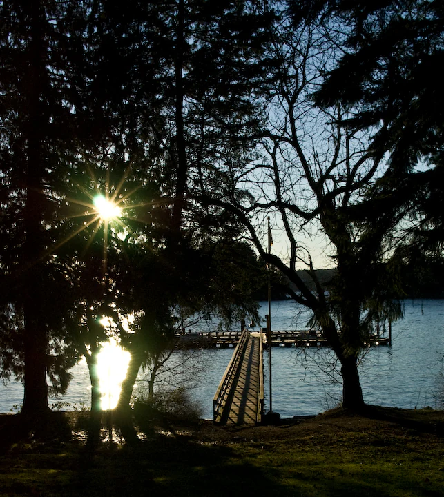
A wooden dock extends into calm water, framed by dark silhouetted trees with the sun shining brightly through the branches on the left.
Sunset view of the public dock at Plumper Cove Marine Provincial Park, framed by silhouetted trees.

Plumper Cove Marine Provincial Park history and protected-area timeline

Plumper Cove Marine Provincial Park was officially established on February 22, 1960, making it one of the earliest marine parks designated along the British Columbia coast. Its creation reflected the growing recognition, during the post-war period, of marine and coastal environments as landscapes worthy of formal protection, separate from the better-known mountain and interior parks of the province.

Over the following decades, the park became a familiar fixture in the roster of BC Parks, valued particularly for its sheltered anchorage in Howe Sound. In 2006, the park's main dock was destroyed by storm damage, and the dock was rebuilt and replaced in 2007, restoring boater access to the site and reaffirming its role as a working marine park. Today it continues to be managed by BC Parks as part of the provincial protected areas system of British Columbia.

Plumper Cove Marine Provincial Park landscape and geographic character

The landscape of Plumper Cove Marine Provincial Park is shaped by the meeting of forest and sheltered saltwater along Howe Sound. The cove itself is a small, protected indentation on the northwest shore of Keats Island, framed by forested slopes and low rocky shoreline. This combination of calm water, rocky edge, and wooded upland is typical of the southern Howe Sound coast, where steep forested ridges descend toward a labyrinth of islands, channels, and quiet inlets.

Inland from the cove, the terrain rises into a low bluff and gently rolling upland covered in coastal forest. The Keats Loop trail leads to a lookout point on higher ground, offering views out over the surrounding waters, while a separate trail connects the park toward Keats Landing on the other side of the island. The bluffs and small elevation changes create a layered experience of marine and terrestrial scenery without demanding strenuous climbing.

Surrounding the park, the broader Howe Sound landscape is defined by steep coastal mountains, scattered islands, and deep blue water. Although much of that dramatic scenery is glimpsed from a distance, it forms the constant backdrop to the park's own more intimate combination of cove, forest, and rocky shore.

Plumper Cove Marine Provincial Park ecosystems, habitats, and plant life

Ecologically, Plumper Cove sits within the coastal western hemlock biogeoclimatic zone that dominates much of British Columbia's southern coast, where mild, wet winters and dry summers support dense coniferous forests. The upland around the park is covered by this kind of evergreen forest, with a mossy understory and the layered structure typical of the Pacific Northwest shoreline.

Below the tideline, the marine environment of Howe Sound supports kelp, eelgrass, and the rocky and gravelly substrates typical of sheltered coastal inlets. The relatively undisturbed shoreline around Plumper Cove contributes to this mix, providing habitat for marine creatures associated with quiet, semi-protected waters along the Salish Sea.

The combined forest and marine setting gives the park an ecological character more aligned with the sheltered southern coast than with the more exposed outer coast of Vancouver Island. The interplay of upland forest, rocky intertidal, and calm cove water means that even within its small footprint, the park protects a representative slice of the southern Howe Sound environment.

Plumper Cove Marine Provincial Park wildlife and species highlights

Because of its forested uplands and sheltered coastal waters, Plumper Cove supports a mix of marine and woodland wildlife characteristic of the southern British Columbia coast. The surrounding waters host fish and marine invertebrates typical of Howe Sound, while the intertidal zone along the cove provides habitat for shore-dwelling creatures adapted to the rhythmic rise and fall of Pacific tides.

The coastal forest on Keats Island provides cover and food for typical southern coast songbirds and larger woodland birds, including bald eagles, which are often seen along shorelines in this region. Small mammals associated with the coastal forest understory are also present, contributing to the general quiet biodiversity of the upland areas.

The combination of forest, shoreline, and open water means the park is best appreciated as a place where marine and terrestrial wildlife overlap. Visitors tend to encounter wildlife as part of the broader experience of the cove, rather than as a single visible spectacle.

Plumper Cove Marine Provincial Park conservation status and protection priorities

Plumper Cove Marine Provincial Park has been part of British Columbia's protected areas system since 1960, giving it one of the longer conservation histories of any marine park on the BC coast. Its protected status is intended to preserve the integrity of the cove, its adjacent forest, and the broader visual and ecological character of this stretch of Howe Sound.

As a marine park in a heavily used recreational waterway, Plumper Cove plays a role in maintaining a natural buffer along an otherwise busy cruising corridor. The combination of upland forest and protected shoreline helps preserve shoreline habitat that might otherwise be impacted by development pressures on the surrounding islands and coastal mainland.

The park is also notable for its management approach, which deliberately limits vehicle access. By relying on marine and foot access rather than road infrastructure, the park reduces the level of disturbance inside its boundaries and supports a quieter form of recreation. This long-running emphasis on low-impact access has been a defining feature of its conservation character.

Plumper Cove Marine Provincial Park cultural meaning and human context

Plumper Cove lies within the broader cultural geography of the southern Salish Sea, where Indigenous peoples including the Squamish, Sechelt, and other Coast Salish communities have long inhabited the islands, inlets, and shorelines of Howe Sound and the Sunshine Coast. The waters around Keats Island and the surrounding mainland form part of the traditional territories of these communities, whose connections to the marine and forest resources of the region extend back many generations.

In the modern era, the park's identity is tied to recreational rather than traditional cultural use. Boaters from Vancouver, Gibsons, and the broader Sunshine Coast region have long used Plumper Cove as an anchorage and overnight stop, and it has become a familiar landmark within the cruising culture of southern British Columbia. The combination of natural setting and boat-only access gives it a particular place within the regional identity of recreational marine travel along this part of the coast.

Top sights and standout views in Plumper Cove Marine Provincial Park

Among the park's strongest qualities is the combination of a sheltered marine anchorage with a forested upland environment rarely found together in such a compact setting. Walk-in campsites tucked into the trees and a grassy upland picnic area offer a quiet, immersive experience of the coastal forest, while the cove itself provides a calm harbor for boaters traveling the waters of Howe Sound.

The trail system, including the Keats Loop lookout and the longer trail toward Keats Landing, adds a hiking dimension uncommon at many purely marine anchorages. The park's status as one of the older marine parks on the British Columbia coast and the deliberate absence of vehicle access together give Plumper Cove a distinctive character that continues to appeal to visitors seeking a quieter side of the southern BC coast.

Best time to visit Plumper Cove Marine Provincial Park

The park's character changes substantially with the seasons. Summer is the most active period, when warmer weather, longer daylight hours, and frequent recreational boating bring more visitors to the cove. This is when the campground and picnic areas are busiest and when camping and moorage fees are typically applied, and it offers the most reliable conditions for anchoring, hiking the trails, and combining a visit with regional cruising along Howe Sound.

Outside of the peak season, the park takes on a quieter and more solitary atmosphere. From late autumn through spring, services are reduced and many facilities are free to use, but the weather along this part of the BC coast is wetter and less predictable, the days are shorter, and access by ferry and water taxi becomes more irregular. Spring and early autumn can offer a useful balance between milder conditions, fewer visitors, and a sense of the park returning to its quieter natural rhythms.
Monthly climate preview

Long-term representative point measurements tracking monthly temperature and precipitation patterns

Plumper Cove Marine Provincial Park Climate Normals and Annual Temperature Rhythm

Representative coordinate records show average temperatures moving from sub-zero winter minimums to warm summer maximums alongside shifting precipitation rates. Examining the full twelve-month profile reveals complete meteorological data for this protected British Columbia location.
Annual mean9 °C
2 °C17 °C
Jan
Feb
Mar
Apr
May12°
Jun14°
Jul17°
Aug17°
Sep14°
Oct
Nov
Dec
Warmest month
August

17.3 °C

Coolest month
December

1.5 °C

Wettest month
November

9.3 mm/day

Driest month
July

1.5 mm/day

Park location guide

Geography guide, regional context, and park location map for Plumper Cove Marine Provincial Park

Plumper Cove Marine Provincial Park park geography, regions, and map view in Canada

Understand where Plumper Cove Marine Provincial Park sits in Canada through a broader geographic reading of the surrounding landscape, nearby location context, and its mapped position within the national park landscape.

How Plumper Cove Marine Provincial Park fits into Canada

Canada is a federal parliamentary constitutional monarchy spanning North America from the Atlantic to the Pacific and Arctic Oceans. With a population of over 41 million, it is officially bilingual in English and French at the federal level. The country gained independence from the United Kingdom through a gradual process culminating in 1982.

Wider geography shaping Plumper Cove Marine Provincial Park in Canada

Canada occupies the northern portion of North America, sharing its longest international border with the United States. The country extends from the Atlantic Ocean to the Pacific Ocean and northward into the Arctic Ocean, giving it the longest coastline of any nation.

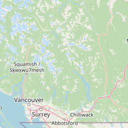
Map view of Plumper Cove Marine Provincial Park

Use this park location map to pinpoint Plumper Cove Marine Provincial Park in Canada, understand its exact geographic position, and read its mapped placement within the surrounding landscape more clearly.

Pigeon | © OpenStreetMap contributors

Location context for Plumper Cove Marine Provincial Park

British Columbia

Visual reference guide to forested shorelines, calm waters, and coastal terrain.

Plumper Cove Marine Provincial Park Photos and Protected Landscape Scenery

Visual records reveal the sheltered marine anchorage and dense coastal forest characterizing Plumper Cove Marine Provincial Park. Photographic documentation provides clear insight into the varied terrain, low rocky bluffs, and protected waters defining the regional ecosystem.

A wooden dock extends into calm water, framed by dark silhouetted trees with the sun shining brightly through the branches on the left.

Park atlas

Compare nearby marine anchorages, protected islands, and coastal forest landscapes

Explore Parks Near Plumper Cove Marine Provincial Park and Surrounding Coastal Reserves

Visitors exploring Plumper Cove Marine Provincial Park can browse other protected areas across the surrounding Salish Sea region and Howe Sound waterways. Comparing these coastal reserves provides broader geographic context on marine parks, island terrain, and regional conservation lands.
A horizontal watercolor illustration depicting soft green rolling hills and distant purple mountains above a flat shoreline with patches of marsh grasses.
State or regional parkBritish Columbia
About 23 km away#1 closest

Northeast

Porteau Cove Provincial Park: Mapping Coastal Protected Landscapes in British Columbia

Geography of Howe Sound shorelines and marine habitats

Porteau Cove Provincial Park offers a unique geographic vantage point at the meeting of granite-sloped mountains and the Pacific waters of Howe Sound. This park detail covers the coastal landscape, including protected intertidal zones, artificial reef structures, and the surrounding terrain that characterizes this segment of the British Columbia coastline.

Area
0.5 km²
Established
1981
IUCN
II
Visitors
611.8K annual
A minimalist watercolor illustration showing rolling hills in the background and soft foliage in the foreground on a white background.
State or regional parkBritish Columbia
About 45 km away#2 closest

Southwest

Petroglyph Provincial Park: Protected Indigenous Heritage and Coastal Geography

Cultural landscape and bedrock carvings in British Columbia

Petroglyph Provincial Park preserves a remarkable concentration of ancient carvings etched into the sandstone bedrock of the Nanaimo River estuary. This protected area on Vancouver Island provides a rare look at how Indigenous traditions integrated with powerful natural features, offering a unique geographic context for studying historical rock art in the Pacific Northwest.

Area
0.02 km²
Established
1948
IUCN
III
Relief
Lowland
A watercolor painting showing a horizontal landscape with a green forest in the foreground and soft pink, layered rolling hills in the background.
State or regional parkBritish Columbia
About 45 km away#3 closest

Southwest

Morden Colliery Historic Provincial Park: Heritage Infrastructure and Regional Coal Mining History

Industrial landscape and historic rail corridor in British Columbia

Located near Nanaimo, this heritage site preserves the substantial concrete remains of the Morden Colliery. The park serves as a physical archive of southern Vancouver Island industrial life, contrasting engineering landmarks with local forest environments and interpretive trails along former coal railway alignments.

Area
0.04 km²
Established
1972
Relief
Lowland
Scope
Terrestrial
A watercolor illustration of a mountain landscape featuring soft rolling hills, evergreen trees, and low-lying vegetation on a white background.
State or regional parkBritish Columbia
About 46 km away#4 closest

East

Pinecone Burke Provincial Park: Coast Mountain Wilderness and Protected Terrain Geography

Mapping a vast ecological corridor in British Columbia

Spanning over 38,000 hectares, Pinecone Burke Provincial Park represents a dramatic transition from the urban proximity of Coquitlam to the remote interiors of the southern Coast Mountains. The landscape is defined by its rugged relief, featuring subalpine meadows, deep freshwater systems, and historically significant forested slopes. This park provides a critical look at the complex topography of the Pacific Northwest, serving as a sanctuary for wildlife and a foundational piece of regional conservation.

Area
380 km²
Established
1995
IUCN
II
Relief
Mountain
A horizontal watercolor painting depicting a light, airy landscape with distant snow-capped mountains, rolling green hills, and coniferous forest edges.
State or regional parkBritish Columbia
About 48 km away#5 closest

Northeast

Garibaldi Provincial Park: An Atlas of Volcanic and Glacial Terrain in British Columbia

Protected wilderness in the Garibaldi Volcanic Belt

Garibaldi Provincial Park preserves a massive expanse of mountainous wilderness, defined by iconic landmarks such as The Black Tusk and Garibaldi Lake. The park represents a crucial study in vertical zonation, transitioning from temperate coastal forests to vast alpine meadows, glaciers, and jagged volcanic summits. Analyze the geological history and mapped protected boundaries that shape this significant British Columbia conservation area.

Area
1,950 km²
Established
1920
IUCN
II
Visitors
136K annual
Watercolor painting of a tranquil body of water with gentle hills in the background and a cluster of trees on the right shore.
State or regional parkBritish Columbia
About 53 km away#6 closest

West

Jedediah Island Marine Provincial Park: Coastal Terrain and Regional Protected Area Map

Mapping island boundaries and sheltered maritime ecosystems

Jedediah Island Marine Provincial Park offers a unique study in coastal geography, featuring a complex shoreline of pebble beaches and indented bays. Located within the Strait of Georgia, the park serves as a protected landmass that blends maritime forest ecosystems with open water corridors. Its boat-only access ensures the landscape remains a quiet, preserved example of Gulf Islands terrain.

Area
6.03 km²
Established
1995
IUCN
II
Relief
Lowland
A pale, minimalist watercolor painting depicting a wide, sandy beach shoreline with a line of evergreen trees in the distance.
State or regional parkBritish Columbia
About 58 km away#7 closest

West

Rathtrevor Beach Provincial Park: Coastal Geography and Protected Land Overview

Vancouver Island coastal terrain and forested landscapes

Spanning over 300 hectares, Rathtrevor Beach Provincial Park protects a rare combination of fine sandy beaches and ancient Douglas fir groves along the Strait of Georgia. This coastal sanctuary on Vancouver Island serves as a critical habitat for migrating birds and represents a preserved segment of regional geography amidst the surrounding developed shoreline.

Area
3.47 km²
Established
1967
IUCN
II
Visitors
836.2K annual
National parkBritish Columbia
About 60 km away#8 closest

South

Gulf Islands National Park Reserve: British Columbia National Park Protected Area

Mapped boundaries and regional geographic context.

Delve into the protected landscape of Gulf Islands National Park Reserve, a significant national park located in British Columbia. This entry provides detailed insights into its mapped boundaries, regional geographic setting, and its identity as a protected area. Understand the park's place within the natural terrain and atlas of Canada, offering a clear geographic overview for focused discovery and landscape context.

Area
36 km²
Established
2003
IUCN
VI
Visitors
28.4K annual

Common questions about visiting, size, designation, and location context for Plumper Cove Marine Provincial Park

Plumper Cove Marine Provincial Park FAQs for park facts, access, geography, and protected area context

Find quick answers about Plumper Cove Marine Provincial Park, including protected-area facts, park geography, trail and visitor context, and how the park fits into its surrounding country and regional landscape.
MoriAtlas Explorer

Continue Your Protected Areas Search Across the Global Atlas

Deepen your exploration by continuing the structured search for national parks and protected areas worldwide. Utilize the comprehensive filtering capabilities to compare different conservation landscapes and refine your understanding of global park geography. Discover more about the distribution and characteristics of protected natural areas.

Global natural geography