

Mori Atlas logo
National parkMount Buffalo National Park

Discover the unique mapped landscape and protected geography of this iconic alpine region.

Mount Buffalo National Park: Victoria's Historic Granite Plateau National Park

Mount Buffalo National Park, nestled in Victoria's alpine northeast, stands as a testament to Australia's early conservation efforts, established in 1898. This national park encompasses a remarkable 31,000-hectare granite plateau, rising majestically within the Australian Alps. Its landscape is defined by striking granite formations, tors, and the prominent peak known as The Horn, offering unparalleled views across the surrounding mountainous terrain. As a significant protected area, Mount Buffalo National Park provides a unique geographic context, showcasing a transition of ecosystems from foothill forests to alpine grasslands, making it a crucial component of Victoria's natural heritage.

Alpine EnvironmentGranite LandscapeMountain PlateauRock FormationsOldest National ParksVictoria

Mount Buffalo National Park

National park

Park overview

Structured park overview, official facts, and landscape profile for Mount Buffalo National Park

Mount Buffalo National Park park facts, protected area profile, and essential visitor context
Review the core facts for Mount Buffalo National Park, including designation, size, terrain, visitor scale, habitats, and operating context in one park-focused overview.

About Mount Buffalo National Park

Mount Buffalo National Park protects a distinctive mountain landscape in Victoria's Alpine region that stands apart from the broader alpine estate through its unique granite character and isolated plateau formation. The park is located approximately 350 kilometres northeast of Melbourne, with the nearest towns being Porepunkah and Bright to the northeast. The centerpiece of the park is Mount Buffalo itself, a moderately high mountain plateau whose granite geology creates dramatic rock formations unlike the surrounding snowgum and alpine ash dominated slopes of the broader Alps. The park takes in not only the plateau but also the surrounding foothill country, encompassing approximately 31,000 hectares of protected terrain. Within the park, the highest point reaches 1,723 metres above sea level at The Horn, a prominent peak accessible by walking track. The park has a long history as a destination, with visitor accommodation at the Mount Buffalo Chalet from 1910 until 2007, and the building has since undergone restoration work. The park supports winter recreation including cross-country skiing at areas like Dingo Dell and Cresta Valley, while the warmer months offer rock climbing, abseiling, hang-gliding, and caving opportunities.

Quick facts and research context for Mount Buffalo National Park

Mount Buffalo National Park occupies a prominent position in Victoria's Alpine region, protecting one of the state's most distinctive mountain landscapes. The park centers on a granite plateau with elevations ranging from roughly 600 metres at the foothills to 1,723 metres at The Horn. First reserved in 1898 around the plateau and Eurobin Falls, the park was progressively expanded, reaching its current extent in 1980. In 2008, the park was added to the Australian National Heritage List as part of the Australian Alps National Parks and Reserves. The park contains over 550 native plant species and supports diverse wildlife adapted to the varying altitudes and habitats.

Park context

Deeper park guide and search-rich context for Mount Buffalo National Park

Mount Buffalo National Park history, landscape, wildlife, and travel context
Explore Mount Buffalo National Park through its history, landscape character, ecosystems, wildlife, conservation priorities, cultural context, and seasonal travel timing in a structured park guide built for atlas discovery and search intent.

Why Mount Buffalo National Park stands out

Mount Buffalo is best known for its remarkable granite plateau and the iconic rock formation called The Horn, which stands as the highest accessible point in the park and provides visitors with 360-degree views of the alpine landscape. The mountain's striking granite boulders and rock formations are a defining visual特征, creating a landscape quite different from the surrounding Victorian Alps. The park is also renowned as one of Australia's earliest protected areas, with its founding in 1898 making it one of the oldest national parks in the country. The Mount Buffalo Chalet, a historic guesthouse built in 1910, overlooks the granite sheets and valleys below, adding architectural character to the natural landscape.

Mount Buffalo National Park history and protected-area timeline

Mount Buffalo National Park was established on 4 November 1898 when an area of approximately 1,166 hectares surrounding the plateau and Eurobin Falls was reserved as a national park, making it one of the oldest national parks in Australia. The initial reservation came during the early era of protected area establishment in Victoria and reflected growing recognition of the mountain's scenic and natural values. In 1908, a road was opened to the plateau and the park was expanded to 10,406 hectares, substantially increasing the protected area. The park was further enlarged in 1980 to its current extent, taking in most of the surrounding foothill country. The Mount Buffalo Chalet was built in 1910 soon after the first road reached the plateau, replacing earlier rustic accommodation and establishing the mountain as a holiday destination. The park became significant for early skiing and ice skating activities, with Mount Buffalo recording the first ski tow in Australia. On 7 November 2008, the park was added to the Australian National Heritage List as one of eleven areas constituting the Australian Alps National Parks and Reserves. The park experienced significant fire impact during the 2006-07 Victorian Alps Fire Complex, when the Cresta Lodge was destroyed though the historic Chalet was saved.

Mount Buffalo National Park landscape and geographic character

The landscape of Mount Buffalo National Park is defined by its distinctive granite plateau and dramatic rock formations that create a unique visual character within the Victorian Alps. The mountain rises as an isolated granite mass with a plateau top characterized by striking boulders, tors, and rock formations sculptured by weathering. The most prominent feature is The Horn, a peak accessible by walking track that provides sweeping 360-degree views across the surrounding alpine country and valleys below. The plateau sits at approximately 1,500 metres elevation, with inverted treelines in valley bottoms giving rise to grasslands and wetland communities. The lower slopes support mixed eucalypt forests of gum and peppermint species, transitioning to pure stands of alpine ash around 1,100 metres, and subalpine woodland of snow gum above 1,300 metres. The park contains scenic waterfalls including Eurobin Falls and the lake system at Lake Catani. Granitic rock faces provide climbing opportunities and habitat for peregrine falcons, while the broader landscape encompasses the Ovens Valley and Buckland Valley views from the plateau edges.

Mount Buffalo National Park ecosystems, habitats, and plant life

The park protects significant alpine and sub-alpine vegetation communities with over 550 native plant species recorded. The most significant vegetation communities are the alpine and sub-alpine associations that transition across the elevational gradient. The lower slopes support mixed eucalypt forests including bogong gum, grading into pure stands of alpine ash around 1,100 metres elevation, and subalpine snow gum woodland above 1,300 metres. The plateau at around 1,500 metres features inverted treelines in valley bottoms with grasslands and wetland communities of sphagnum and empodisma in watercourses. Several plant species are endemic to the park, including the Buffalo sallee eucalypt, Buffalo grevillea, Buffalo sallow wattle, and fern-leaf baeckea. Grazing was excluded from the park in 1957, representing one of the earliest exclusions of this activity in any alpine park in Victoria. The park also supports enormous fungal diversity with several hundred species recorded, including lichens and mycorrhizal fungi that support the broader plant community.

Mount Buffalo National Park wildlife and species highlights

The varying altitude range within the park creates diverse fauna habitats supporting numerous species. The foothill forests contain kangaroos, wallabies, and several species of possums and sugar gliders, while smaller mammals such as native rats and mice inhabit the plateau. Wombats occur in all habitats throughout the park. The alpine silver xenica butterfly is a species found only on the plateau of Mount Buffalo, representing a significant endemism. Bogong moths shelter in rock crevices at The Horn, forming a seasonal food resource that attracts birds feeding on them during the day and bats at night. Peregrine falcons nest in the granite rock faces, and crimson rosellas are abundant throughout the park. The park's position within the Australian Alps makes it important for migratory and alpine-adapted species.

Mount Buffalo National Park conservation status and protection priorities

Mount Buffalo National Park was added to the Australian National Heritage List on 7 November 2008 as one of eleven areas constituting the Australian Alps National Parks and Reserves, recognizing its outstanding national heritage values. The park protects significant alpine ecosystems and geological features that are important within Victoria's protected area network. As one of Australia's oldest national parks, established in 1898, it represents early conservation recognition of mountain landscapes. The exclusion of grazing in 1957 was a pioneering management decision for alpine parks in Victoria. The park faces ongoing management challenges from weed species including Himalayan honeysuckle, yarrow, and blackberries. The 2006-07 Victorian Alps Fire Complex significantly impacted the park, with dead trees from the fire still visible across parts of the plateau, demonstrating the ecological recovery challenges following major fire events.

Mount Buffalo National Park cultural meaning and human context

Mount Buffalo has cultural significance for the Taungurung people, part of the Kulin nation, who climbed the mountain in summer to feast on protein-rich bogong moths and to meet and hold ceremonies. The traditional name Mitambuta relates to this place. European explorers Hume and Hovell named the mountain in 1824, observing its supposed resemblance to a reclining buffalo. Gold miners and botanists later visited the area, and with the development of tourism in the 1880s, the area around the Gorge was reserved as a national park in 1898. The Mount Buffalo Chalet, built in 1910, operated as a Victorian Railways guesthouse with railway-themed services including refreshment rooms and railway uniformed staff. The park represents a long history of human engagement with this distinctive mountain landscape.

Top sights and standout views in Mount Buffalo National Park

The standout features of Mount Buffalo National Park include the dramatic granite plateau with its iconic rock formation The Horn offering panoramic views, the historic Mount Buffalo Chalet overlooking granite sheets and alpine valleys, the diversity of recreation opportunities from rock climbing and hang-gliding to cross-country skiing, and the park's significant position as one of Australia's oldest national parks. The endemic alpine silver xenica butterfly and the park's several endemic plant species highlight its ecological distinctiveness. The granite rock faces supporting peregrine falcon nesting and the seasonal bogong moth congregations at The Horn represent notable wildlife features.

Best time to visit Mount Buffalo National Park

Mount Buffalo National Park offers different experiences across seasons. The summer months from November to April bring warmer conditions suitable for walking, climbing, and exploring the plateau, with the camping ground at Lake Catani operating during this period. The cooler shoulder seasons of autumn and spring offer mild conditions for bushwalking and photography with fewer crowds. Winter transforms the mountain into a destination for cross-country skiing, with trails near the cathedral at Cresta and toboggan runs at Dingo Dell and Cresta Valley suitable for beginners and experienced skiers alike. The alpine climate means temperatures drop significantly at higher elevations, and the park receives substantial winter precipitation including snow. The seasonal variation in conditions means visitors should prepare for quite different experiences depending on when they choose to visit.
Park location guide

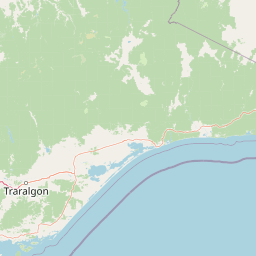
Geography guide, regional context, and park location map for Mount Buffalo National Park

Mount Buffalo National Park park geography, regions, and map view in Australia
Understand where Mount Buffalo National Park sits in Australia through a broader geographic reading of the surrounding landscape, nearby location context, and its mapped position within the national park landscape.

How Mount Buffalo National Park fits into Australia

Australia is a constitutional monarchy and federal parliamentary democracy comprising six states and ten territories. With a population of nearly 28 million, it is one of the world's most urbanised countries, with most people concentrated on the eastern seaboard. The country has a high Human Development Index and is known for its cultural diversity, ancient Aboriginal heritage, and unique wildlife.

Wider geography shaping Mount Buffalo National Park in Australia

Australia occupies the entire Australian continent, the island of Tasmania, and numerous smaller islands. It is the world's flattest and driest inhabited continent, featuring vast deserts in the interior (the Outback), tropical rainforests along the eastern coast, and a coastline bordering the Indian and Pacific Oceans.

Map view of Mount Buffalo National Park

Use this park location map to pinpoint Mount Buffalo National Park in Australia, understand its exact geographic position, and read its mapped placement within the surrounding landscape more clearly.

Pigeon | © OpenStreetMap contributors
Park atlas

Explore the protected landscapes and mountain geography of Victoria's alpine region beyond Mount Buffalo.

Discover Other National Parks and Protected Areas Near Mount Buffalo National Park
Continue your exploration of Australia's protected areas by browsing national parks and reserves situated near Mount Buffalo National Park in Victoria's alpine region. Compare the distinct granite landscapes and diverse ecosystems of adjacent protected territories, gaining broader geographic context for the Australian Alps.
National park

Alpine National Park: Victoria's Expansive National Park in the Great Dividing Range

Mapping significant alpine, subalpine, and mountain wilderness landscapes.

Alpine National Park represents Victoria's largest protected area, safeguarding critical alpine and subalpine environments across the Great Dividing Range. This national park encompasses vast mountainous terrain, including Victoria's highest peaks like Mount Bogong, and the expansive Bogong High Plains known for their unique grassland and woodland ecosystems. The park's protected landscape offers rich opportunities for geographic discovery and understanding its place within Australia's significant mountain wilderness regions.

Area
6,474 km²
Established
1989
IUCN
II
Relief
Mountain
National park

Warby-Ovens National Park: Protected Landscape and Geographic Atlas Entry

Discover its Box-Ironbark forests and mapped regional terrain.

Warby-Ovens National Park is a protected national park situated in northeastern Victoria, Australia, covering 14,655 hectares of distinctive landscape. It is internationally recognized as an Important Bird Area, primarily for its significant Box-Ironbark forest ecosystem that supports numerous threatened woodland bird species. The park's geography features low granite hills and rolling terrain, with the Ovens River flowing through its northern section. This detail page provides structured information on its protected boundaries, natural landscape characteristics, and its place within regional geography.

Area
146.55 km²
Established
2010
IUCN
II
Relief
Upland
Watercolor illustration showing a lake surrounded by green hills and vegetation
National park

Lake Eildon National Park: Protected Landscape with Ancient Volcanic and Gold Mining Heritage

Explore mapped terrain and diverse eucalypt forests.

Lake Eildon National Park in Victoria's Central Highlands offers a unique protected landscape shaped by ancient volcanic activity and the region's gold rush era. This national park, centered around the large Lake Eildon reservoir, provides critical habitat within its diverse eucalypt forests. Discover its geological significance, historical mining sites, and mapped boundaries, offering a comprehensive view of its protected-area identity and regional geographic context.

Area
277.5 km²
Established
1997
IUCN
II
Relief
Mountain
National parkNew South Wales

Benambra National Park: New South Wales Protected Area and Great Yambla Range Map

Explore mapped terrain and woodland ecosystems.

Benambra National Park serves as a key protected area in New South Wales, preserving crucial white box and Red Box woodland communities against a backdrop of the Great Yambla Range's dramatic topography. This national park is significant for its role in conserving habitat for at least twelve threatened bird species and its unique geological features, including cliff faces and flat-topped peaks. Understanding the park's mapped boundaries and its place within the South West Slopes region offers valuable context for geographic discovery and the study of Australia's natural landscapes.

Area
13.99 km²
Established
2001
IUCN
II
Relief
Mixed relief
National park

Burrowa-Pine Mountain National Park: Australia's Iconic Granite Monolith and Mountain Wilderness

Explore its mapped boundaries and unique regional geography.

Burrowa-Pine Mountain National Park stands as a prominent protected wilderness in Victoria, Australia, renowned for its spectacular geological features. The park is dominated by the colossal Pine Mountain, a massive sandstone monolith that commands the landscape, and the elevated Mount Burrowa, offering expansive vistas across the Victorian Alps. Its mountainous terrain, characterized by rocky ridgelines and alpine forests, makes it a distinctive destination for understanding Australia's natural and geographic heritage. Discover the mapped extent and landscape character of this important national park.

Area
184 km²
Established
1978
IUCN
II
Relief
Mountain
National parkNew South Wales

Woomargama National Park: National Park Protected Area with Mapped Landscape Identity

Discover the geographic context and park boundaries.

Woomargama National Park serves as a distinct entity for geographic exploration within New South Wales. As a designated national park, its protected landscape identity is integral to understanding the regional map. This profile facilitates detailed study of its position, natural terrain context, and role within Australia's network of conservation areas, providing structured data for atlas-based discovery.

Area
241.85 km²
Established
2001
IUCN
II
Relief
Upland
National park

Baw Baw National Park: Subalpine Granite Landscapes and Protected Area Geography

Discover Victoria's southernmost alpine wilderness.

Baw Baw National Park offers a rare glimpse into Australia's subalpine environment, characterized by striking granite boulder formations and iconic snow gum forests. As a protected national park, it safeguards unique ecosystems and habitats, including those for critically endangered species. This atlas entry details the park's distinctive landscape, its mapped boundaries, and its geographic significance as the southern edge of mainland alpine terrain.

Area
135.3 km²
Established
1979
IUCN
II
Relief
Mountain
National park

Yarra Ranges National Park: Victoria's Towering Mountain Ash Forests and Protected Landscape Geography

Explore mapped boundaries and vital water catchment landscapes.

Yarra Ranges National Park in Victoria, Australia, represents a significant protected landscape within the Great Dividing Range. It is renowned for its exceptionally tall mountain ash forests, which are vital carbon stores and habitats, and its critical function as a water catchment area for Melbourne. This park offers a deep dive into a unique geographic setting defined by diverse mountain terrain, temperate rainforests, and subalpine environments, all preserved for their ecological and water security importance.

Area
760 km²
Established
1995
IUCN
II
Visitors
800K annual

Common questions about visiting, size, designation, and location context for Mount Buffalo National Park

Mount Buffalo National Park FAQs for park facts, access, geography, and protected area context
Find quick answers about Mount Buffalo National Park, including protected-area facts, park geography, trail and visitor context, and how the park fits into its surrounding country and regional landscape.
MoriAtlas Explorer

Continue Your Protected Areas Search Across the Global Atlas

Deepen your exploration by continuing the structured search for national parks and protected areas worldwide. Utilize the comprehensive filtering capabilities to compare different conservation landscapes and refine your understanding of global park geography. Discover more about the distribution and characteristics of protected natural areas.

Global natural geography