

Mori Atlas logo
National parkMount Remarkable National Park

Mapping the protected boundaries and natural terrain of this significant South Australian national park.

Mount Remarkable National Park: South Australia's Protected Landscape and Geographic Context

Mount Remarkable National Park represents a key protected area within the diverse geography of South Australia. This page offers an atlas-driven exploration of the park's precise mapped boundaries and its place within the regional landscape. Understand the park's geographic identity and how its protected terrain contributes to the natural context of South Australia.

Mountain parksBirdwatchingFlinders RangesEucalyptus forestsProtected wildlife habitatSouth Australian parks

Mount Remarkable National Park

National park

Park overview

Structured park overview, official facts, and landscape profile for Mount Remarkable National Park

Mount Remarkable National Park park facts, protected area profile, and essential visitor context
Review the core facts for Mount Remarkable National Park, including designation, size, terrain, visitor scale, habitats, and operating context in one park-focused overview.

About Mount Remarkable National Park

Mount Remarkable National Park occupies a significant position in South Australia's protected area network, situated in the southern Flinders Ranges approximately 238 kilometres north of Adelaide and 25 kilometres east of Port Augusta. The park's landscape is dominated by rugged mountain terrain centred on Mount Remarkable, which rises to 960 metres and provides dramatic backdrop to the surrounding countryside. The park comprises two separate land parcels: the main block encompassing 165.83 square kilometres immediately west of the town of Melrose, and a much smaller Telowie Block of 0.35 square kilometres located near Port Germein. This mountainous region represents the southernmost extension of the Flinders Ranges, a major mountain range that forms the backbone of South Australia's landscape. The park's ecological significance stems from its position as a geographical barrier between semi-arid plant communities in eastern and western Australia, creating a unique mixing zone where species from different climatic zones co-occur. The terrain features deep gorges, rocky ridges, and forested slopes that support diverse habitats ranging from open eucalyptus woodlands to rocky outcrops and creek lines.

Quick facts and research context for Mount Remarkable National Park

Mount Remarkable National Park spans approximately 166 square kilometres in its main parcel near Melrose, with an additional small Telowie Block near Port Germein. The park is classified as IUCN Category VI, reflecting its status as a protected area with sustainable use of natural resources. It is managed by the South Australia's Department of Environment and Water. The park features Mount Remarkable peak at 960 metres elevation and encompasses the dramatic terrain of the southern Flinders Ranges, including significant geological features like Alligator Gorge and Mambray Creek. The park supports 117 native bird species and represents a critical transition zone where semi-arid and temperate Australian flora intersect.

Park context

Deeper park guide and search-rich context for Mount Remarkable National Park

Mount Remarkable National Park history, landscape, wildlife, and travel context
Explore Mount Remarkable National Park through its history, landscape character, ecosystems, wildlife, conservation priorities, cultural context, and seasonal travel timing in a structured park guide built for atlas discovery and search intent.

Why Mount Remarkable National Park stands out

Mount Remarkable National Park is best known for its dramatic mountain landscapes in the southern Flinders Ranges and its remarkable ecological position at the intersection of Australia's arid and temperate biomes. The park protects the distinctive Mount Remarkable peak at 960 metres and features significant geological formations including Alligator Gorge and the Mambray Creek valley. It is renowned for its remarkable biodiversity, hosting 117 native bird species including wedge-tailed eagles and Australian ringnecks, as well as a unique mixture of vegetation types including sugar gum forests, various box eucalypts, and the southernmost occurrences of many plant species more typical of the Great Dividing Range.

Mount Remarkable National Park history and protected-area timeline

The protected area history of Mount Remarkable dates to 1952 when land associated with Mambray Creek and Alligator Gorge first obtained protected status as "national pleasure resorts" under the National Pleasure Resorts Act 1914. These early protected areas were managed by the South Australian Government Tourist Bureau from 1952 until 1967. In 1964, the National Parks Commission submitted a proposal to the South Australian Government for establishing "comprehensive national parks" covering larger areas than the existing national pleasure resorts. This initiative led to the creation of three separate wildlife reserves: the Alligator Gorge Wildlife Reserve (constituted in July 1965), the Mambray Creek Wildlife Reserve (September 1967), and the Mount Remarkable Wildlife Reserve (March 1966). In 1972, these three wildlife reserves were re-proclaimed under the National Parks and Wildlife Act 1972 as the Mount Remarkable National Park. Between 1972 and 1993, the park doubled in size from 8,236 hectares through the addition of land including the Black Range Lookout and the Bluff in 1976, and subsequently through the addition of an area west of Alligator Gorge containing The Battery, two parts of the Willowie Forest Reserve, and the Napperby Block in 1993. In 2000, further land was added and named The Warren Bonython Link in honour of Warren Bonython's long personal interest in the area and his association with the National Parks Foundation. On 26 November 2021, the Napperby Block was separated from the park and combined with several conservation parks to create the new Wapma Thura–Southern Flinders Ranges National Park.

Mount Remarkable National Park landscape and geographic character

The landscape of Mount Remarkable National Park is characterised by rugged mountain terrain in the southern Flinders Ranges, featuring dramatic relief and varied topography. The park's centrepiece, Mount Remarkable, rises to 960 metres above sea level and forms a prominent peak visible across the surrounding plains. The terrain includes deep rocky gorges such as Alligator Gorge, where ancient geological formations create imposing cliff walls and narrow passages. The Mambray Creek area features more undulating terrain with creek lines cutting through the landscape. Rocky ridges and outcrops are common throughout the park, interspersed with forested slopes and open woodland areas. The landscape reflects the geological history of the Flinders Ranges, which represent the eroded remnants of ancient mountain ranges that once dominated this part of Australia. The combination of elevation changes, rocky terrain, and vegetation creates a landscape of considerable scenic value, with views from the higher points offering panoramic perspectives across the southern Flinders and surrounding pastoral countryside.

Mount Remarkable National Park ecosystems, habitats, and plant life

Mount Remarkable National Park occupies a critical ecological position as a transition zone between Australia's arid interior and the temperate environments of the southeast. This geographic location creates a unique biodiversity hotspot where species from semi-arid eastern and western Australia meet and overlap. The park features a distinctive mixture of arid and temperate flora, with temperate tree species common in the Great Dividing Range such as white box, long-leaved box, grey box, and South Australian blue gum reaching their most northerly expressions in the park. The sugar gum, a forest-forming eucalypt that represents a relict tree of wetter times in South Australia's history, forms significant woodland in the park. The Flinders Ranges variety of sugar gum is Eucalyptus cladocalyx petila, capable of growing to 40 metres tall and forming the most northerly biome of open forest in South Australia. Other significant plant species include rusty pods, a bush with purple pea flowers that is otherwise found only in the higher parts of the Great Dividing Range and occurs commonly along the Mount Remarkable Range with outliers in Wirrabara forest, Mount Brown and Mount Aleck.

Mount Remarkable National Park wildlife and species highlights

Mount Remarkable National Park supports a rich fauna community with 117 native bird species recorded within its boundaries. Notable bird species include the Australian ringneck and the wedge-tailed eagle, one of Australia's largest birds of prey. The park also provides habitat for a variety of reptiles, mammals and other birds including goannas, emus, echidna and kookaburras. This diversity of wildlife reflects the park's ecological significance as a mixing zone between different biomes, allowing species from various environmental backgrounds to coexist. The combination of forested areas, rocky outcrops, and open woodland provides varied habitat types supporting different wildlife communities. The presence of emus, Australia's largest native bird, indicates the park's position in a landscape that retains relatively natural vegetation cover and ecological connectivity.

Mount Remarkable National Park conservation status and protection priorities

Mount Remarkable National Park represents an important conservation outcome in South Australia's protected area network, established to protect the significant natural and scenic values of the southern Flinders Ranges. The park is classified as an IUCN Category VI protected area, reflecting its management approach that allows for sustainable use of natural resources while maintaining conservation values. The park's conservation significance is enhanced by its role as a biodiversity hotspot at the crossroads of Australia's major ecological zones, protecting unique assemblages of species that occur nowhere else. The protection of the sugar gum forests and the various box eucalypt communities represents preservation of vegetation types that have contracted from their historical range due to climate changes and land clearing. The park's history of expansion through land additions demonstrates ongoing commitment to protecting additional significant habitat areas and connecting conservation outcomes across the landscape.

Mount Remarkable National Park cultural meaning and human context

The Mount Remarkable area has historical significance dating to European exploration and settlement of the Flinders Ranges region. The town of Melrose, established nearby, represents one of the earliest settlements in the northern Flinders Ranges. The use of Mambray Creek and Alligator Gorge as "national pleasure resorts" from 1952 reflects early recognition of the area's scenic and recreational value. The landscape has been shaped by both natural processes and human activity over the period of European settlement, with the park incorporating former forest reserve lands. The park's name derives from Mount Remarkable, the prominent peak that has served as a landmark in the region. The more recent establishment of the Wapma Thura–Southern Flinders Ranges National Park, which absorbed the former Napperby Block, reflects evolving approaches to conservation planning in the Flinders Ranges region.

Top sights and standout views in Mount Remarkable National Park

The standout features of Mount Remarkable National Park include the dramatic 960-metre peak of Mount Remarkable offering panoramic views, the deep impressive gorge of Alligator Gorge, and the scenic Mambray Creek valley with its walking trails. The park's exceptional biodiversity, with 117 native bird species and unique mixing of arid and temperate flora, makes it a significant ecological destination. The sugar gum forests represent some of the most northerly open forest in South Australia, while the presence of species like rusty pods normally found only in the Great Dividing Range demonstrates the park's biogeographical importance. The network of walking trails, including the Daveys Gully walking trail with its panoramic views, provides opportunities to experience the park's varied landscapes and wildlife.

Best time to visit Mount Remarkable National Park

The cooler months from late autumn through winter to early spring, typically May to October, generally offer the most comfortable conditions for exploring Mount Remarkable National Park. During these seasons, daytime temperatures are more moderate and suitable for walking and outdoor activities, while the park's landscapes showcase the characteristic vegetation of the region. Winter and early spring can bring wildflower displays in some years, adding colour to the landscape. Summer months can be very hot in this part of South Australia, making comfortable outdoor activity more challenging. The park can be visited year-round, but visitors should be prepared for variable conditions and should check current conditions before traveling.
Park location guide

Geography guide, regional context, and park location map for Mount Remarkable National Park

Mount Remarkable National Park park geography, regions, and map view in Australia
Understand where Mount Remarkable National Park sits in Australia through a broader geographic reading of the surrounding landscape, nearby location context, and its mapped position within the national park landscape.

How Mount Remarkable National Park fits into Australia

Australia is a constitutional monarchy and federal parliamentary democracy comprising six states and ten territories. With a population of nearly 28 million, it is one of the world's most urbanised countries, with most people concentrated on the eastern seaboard. The country has a high Human Development Index and is known for its cultural diversity, ancient Aboriginal heritage, and unique wildlife.

Wider geography shaping Mount Remarkable National Park in Australia

Australia occupies the entire Australian continent, the island of Tasmania, and numerous smaller islands. It is the world's flattest and driest inhabited continent, featuring vast deserts in the interior (the Outback), tropical rainforests along the eastern coast, and a coastline bordering the Indian and Pacific Oceans.

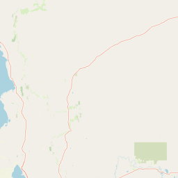
Map view of Mount Remarkable National Park

Use this park location map to pinpoint Mount Remarkable National Park in Australia, understand its exact geographic position, and read its mapped placement within the surrounding landscape more clearly.

Pigeon | © OpenStreetMap contributors

Location context for Mount Remarkable National Park

South Australia
Park atlas

Trace the mapped geography of protected areas surrounding Mount Remarkable National Park for regional comparison.

Explore Other National Parks Near Mount Remarkable National Park and the Southern Flinders Ranges
Explore other national parks and protected areas geographically adjacent to Mount Remarkable National Park within the southern Flinders Ranges and broader South Australian region. This structured view supports comparative discovery, allowing users to trace regional protected-area patterns and understand local conservation landscapes.
National parkSouth Australia

Wapma Thura, Southern Flinders Ranges National Park: South Australia's Protected Natural Landscape

Explore mapped boundaries and regional geography.

Wapma Thura, Southern Flinders Ranges National Park offers a distinct protected landscape within South Australia. This page serves as a portal for understanding its geographic setting, its role as a national park, and its place within the state's atlas of natural areas. Examine the mapped terrain and protected boundaries to grasp the park's unique geographic characteristics.

Established
2021
IUCN
II
Relief
Mountain
Scope
Terrestrial
National parkSouth Australia

Lake Torrens National Park: Explore South Australia's Remarkable Inland Salt Lake Geography

A unique protected landscape of arid plains and expansive salt flats.

Lake Torrens National Park offers an unparalleled exploration of Australia's remote outback, centered around a vast, ancient salt lake basin. This national park in South Australia provides a canvas of stark, minimalist terrain, featuring shimmering saltpans, arid gibber plains, and rocky outcrops. Understand the park's unique geographic identity, its ecological significance as a temporary wetland habitat, and its dramatic visual appeal for landscape photography and geological interest. It is a key protected area showcasing the extreme environment of Australia's interior.

Area
5,676.68 km²
Established
1991
IUCN
VI
Relief
Lowland
National parkSouth Australia

Nilpena Ediacara National Park: South Australia National Park and Protected Landscape Identity

Mapped protected area within the regional geography of South Australia.

Nilpena Ediacara National Park represents a significant protected landscape within South Australia. This entry provides a detailed geographic context for the park, focusing on its role as a national park and its mapped boundaries. Delve into the specific atlas-driven understanding of this protected area, its landscape context, and its significance within the broader geographic framework of the Australian state.

Area
606.17 km²
Established
2021
IUCN
VI
Relief
Mountain
National parkSouth Australia

Lake Gairdner National Park: National Park with Unique South Australian Geography and Mapped Boundaries

South Australian protected area with distinct landscape characteristics.

Lake Gairdner National Park serves as a key protected area within the geographic expanse of South Australia. This national park offers a unique focus for atlas exploration, highlighting its specific landscape features and mapped boundaries. Users can delve into the park's protected status and its contribution to the regional geography, providing valuable context for understanding Australia's diverse natural protected lands and their cartographic representation.

Area
5,531.77 km²
Established
1991
IUCN
VI
Relief
Lowland
National parkAdelaide Hills

Cleland National Park: Mapped Protected Landscape and Regional Geographic Context

Discover the natural terrain and park boundaries within Adelaide Hills.

Cleland National Park offers a critical lens into the protected landscapes of South Australia's Adelaide Hills. As a national park, its mapped boundaries and geographic position are key elements for understanding regional natural terrain. This resource facilitates atlas-style exploration of Cleland National Park, highlighting its importance within the conservation framework and providing a foundation for detailed geographic study.

Area
11.25 km²
Established
1945
IUCN
II
Visitors
100K annual
National parkSouth Australia

Belair National Park National Park: South Australia Protected Landscape and Map Exploration

Explore the geographic context and mapped boundaries of this South Australian protected area.

Belair National Park represents a significant protected land entity within South Australia, offering specific geographic insights relevant to atlas exploration. As a designated national park, its mapped boundaries and landscape character are essential for understanding regional conservation efforts. This profile provides foundational information on the park's identity as a protected natural area, anchoring its position within the geography of South Australia for detailed map-based discovery and regional context.

Area
8.35 km²
Established
1891
IUCN
II
Visitors
358.6K annual
National parkSouth Australia

Onkaparinga River National Park: National Park Protected Landscape in South Australia

Explore mapped boundaries and regional geographic context.

Onkaparinga River National Park is a designated national park within South Australia, offering a focused point for understanding protected landscapes. This entry provides detailed geographic context, highlighting the park's mapped boundaries and its place within the regional atlas. Engage with the specific geography and protected-area identity of Onkaparinga River National Park to enhance your landscape exploration.

Area
15.42 km²
Established
1993
IUCN
II
Relief
Upland
National parkSouth Australia

Lake Frome National Park: Mapped Protected Area and Regional Geographic Identity in South Australia

Explore South Australia's unique landscape and park boundaries.

Lake Frome National Park offers a distinct focus for exploring the geography and protected landscape of South Australia. As a national park, it contributes to the mapped conservation network of the region, allowing for detailed study of its environmental context and geographic positioning. Discover the mapped terrain and regional park boundaries that define this significant protected area, crucial for a comprehensive atlas-based understanding of South Australia's natural heritage.

Area
2,582.4 km²
Established
1991
IUCN
VI
Relief
Lowland

Common questions about visiting, size, designation, and location context for Mount Remarkable National Park

Mount Remarkable National Park FAQs for park facts, access, geography, and protected area context
Find quick answers about Mount Remarkable National Park, including protected-area facts, park geography, trail and visitor context, and how the park fits into its surrounding country and regional landscape.
MoriAtlas Explorer

Continue Your Protected Areas Search Across the Global Atlas

Deepen your exploration by continuing the structured search for national parks and protected areas worldwide. Utilize the comprehensive filtering capabilities to compare different conservation landscapes and refine your understanding of global park geography. Discover more about the distribution and characteristics of protected natural areas.

Global natural geography