

Mori Atlas logo
Marine protected areaMurat Marine Park

Mapped boundaries and ecological features of a protected marine landscape in South Australia

Murat Marine Park: Exploring the Marine Protected Area Geography and Continental Shelf

Murat Marine Park preserves a significant section of the Great Australian Bight Shelf Transition, connecting shallow inshore environments with deeper continental shelf waters. This marine protected area encompasses diverse seafloor habitats ranging from 15 to 70 metres in depth, including the geologically distinct submerged Yatala Reef system. As part of the South-west Marine Parks Network, the territory serves as a critical feeding ground for species including the Australian sea lion and great white shark within the Southern Ocean.

marine protected areaGreat Australian Bightcontinental shelfsubmerged reefkey ecological featurespelagic fish

Murat Marine Park

Marine protected area

Park overview

Structured park overview, official facts, and landscape profile for Murat Marine Park

Murat Marine Park park facts, protected area profile, and essential visitor context

Review the core facts for Murat Marine Park, including designation, size, terrain, visitor scale, habitats, and operating context in one park-focused overview.

About Murat Marine Park

Murat Marine Park is a Commonwealth marine protected area in the Great Australian Bight, off the southern coast of South Australia. Positioned west of the Nuyts Archipelago and well offshore from the small coastal settlement of Fowlers Bay, the park protects a stretch of open ocean that lies entirely within Australia's Exclusive Economic Zone rather than in state waters. It is managed at the national level by the Director of National Parks and forms part of the larger South-west Marine Parks Network that links reserves across Australia's southern coastline.

The marine park covers a substantial area of temperate continental shelf seafloor, with depths that range from relatively shallow waters near 15 metres down to about 70 metres at the outer edge of the reserve. This depth range places Murat firmly within the shelf zone, where sunlight still penetrates to the seabed and where soft-sediment communities and deeper patch habitats coexist. The park's setting, isolated from major coastal development and centred on open ocean, gives it a strong conservation character and supports several ecological processes that operate at a regional scale.

A defining aspect of Murat Marine Park is its connection to the Great Australian Bight Shelf Transition, a marine feature recognised for bridging different depth zones and habitat types along the southern Australian margin. The reserve includes examples of benthic invertebrate communities, areas important for small pelagic fish, and key feeding zones for larger predators and seabirds. Together, these features highlight the park's role not only as a local reserve but as a meaningful component of broader marine planning for the Bight region.

Quick facts and research context for Murat Marine Park

Murat Marine Park is a Commonwealth marine reserve located in the Great Australian Bight, off the coast of South Australia, within Australia's Exclusive Economic Zone. It lies west of the Nuyts Archipelago and includes waters that span the continental shelf down to the outer shelf transition zone.

The park was gazetted in November 2012 and renamed Murat Marine Park in October 2017. It forms part of the South-west Marine Parks Network and is managed by the Director of National Parks under IUCN Category II protection status.

Protection and recognition

Examine the formal conservation framework and marine protection metrics

Murat Marine Park Protection Status and Designated Area Records

Consolidated protection records outline the formal marine status and governance parameters established for Murat Marine Park. Structured administrative metrics present documented designation details without inferring specific conservation outcomes.

Protection details

Protection scope
Marine
Transboundary protection
No
Park context

Deeper park guide and search-rich context for Murat Marine Park

Murat Marine Park history, landscape, wildlife, and travel context

Explore Murat Marine Park through its history, landscape character, ecosystems, wildlife, conservation priorities, cultural context, and seasonal travel timing in a structured park guide built for atlas discovery and search intent.

Why Murat Marine Park stands out

Murat Marine Park is best known for protecting a representative stretch of the Great Australian Bight Shelf Transition, one of the recognised large-scale marine features along Australia's southern continental margin. The park's waters link shallower inshore environments with the deeper shelf break, creating a productive ecological transition that supports diverse marine life. It is also notable for its role as a feeding ground for several high-profile species, including the Australian sea lion, the great white shark, the short-tailed shearwater, and the Caspian tern. In addition, the reserve includes the submerged Yatala Reef system, an unusual offshore reef feature that adds geomorphic diversity to an otherwise sediment-dominated shelf environment.

Murat Marine Park history and protected-area timeline

Murat Marine Park originated as the Murat Commonwealth Marine Reserve, an offshore Commonwealth marine reserve established through the Australian government's South-west marine planning process. The reserve was gazetted in November 2012 as part of the South-west Marine Parks Network, grouping several Commonwealth marine reserves along Australia's southern coast.

In 2017, the reserve was renamed Murat Marine Park, reflecting a broader shift toward consistent naming across Australia's Commonwealth marine reserves and aligning the reserve more clearly with the federal marine parks framework. Despite the change in name, the park's geographic boundaries, ecological objectives, and management arrangements continued under the same statutory system, with oversight by the Director of National Parks and continued IUCN Category II classification.

Murat Marine Park landscape and geographic character

Murat Marine Park's landscape is defined entirely by the marine environment beneath the southern Australian seas. Rather than cliffs, forests, or mountain ridges, the park's scenery consists of open ocean stretching across the continental shelf, with the seafloor descending gradually from shallow waters to moderately deeper shelf habitats.

Depths within the park range from about 15 metres to 70 metres, placing the reserve within the photic zone where light still reaches the seabed. The substrate across much of the area is expected to consist of soft sediments typical of wide continental shelf environments, but the park also incorporates the submerged Yatala Reef system, which introduces hard-substrate and elevated reef structure into an otherwise flat sedimentary setting. Surrounding the park, the larger setting includes the wider Great Australian Bight, with the Nuyts Archipelago lying to the east and the open Southern Ocean extending southward.

Murat Marine Park ecosystems, habitats, and plant life

Ecologically, Murat Marine Park represents an important example of the Great Australian Bight Shelf Transition, a marine feature recognised for linking shallower inshore shelf environments with deeper offshore habitats. This transition zone is known for its productivity and for supporting communities that depend on the meeting of different water masses and seabed conditions.

The park incorporates several recognised key ecological features. These include notable benthic invertebrate communities living on and within the seafloor, and areas that are important for small pelagic fish, which form a fundamental link in the southern Australian marine food web by transferring energy from plankton to larger predators. Combined with the inclusion of Yatala Reef, the reserve showcases a mix of soft-sediment and reef-based habitats within a relatively compact offshore area.

Murat Marine Park wildlife and species highlights

Wildlife significance in Murat Marine Park centres on its role as a feeding area for several high-profile marine and seabird species. The Australian sea lion, a species endemic to southern Australian waters, is among the marine mammals documented to use the area. The park also provides feeding habitat for the great white shark, a wide-ranging apex predator that hunts in shelf and shelf-break waters along the southern Australian coast.

The short-tailed shearwater, a migratory seabird that breeds in large colonies around southern Australia and disperses widely across surrounding seas, is recognised as using the park area for feeding. The Caspian tern, another seabird dependent on productive marine waters, is also recorded. Beyond these specific species, the broader pelagic and benthic communities within the park support a wider network of marine life, with small pelagic fish serving as prey for larger fish, sharks, seabirds, and marine mammals throughout the Bight ecosystem.

Murat Marine Park conservation status and protection priorities

Murat Marine Park holds clear conservation significance as a federal marine reserve within the South-west Marine Parks Network. Its IUCN Category II status reflects recognition of the park's value for ecosystem protection, biodiversity conservation, and the safeguarding of nationally important marine habitat. By protecting a representative section of the Great Australian Bight Shelf Transition, the park contributes to maintaining ecological connectivity along Australia's southern continental margin.

The reserve's identification of key ecological features, including benthic invertebrate communities and areas important for small pelagic fish, gives it a defined role in marine conservation planning and in monitoring the health of broader Bight ecosystems. The inclusion of the submerged Yatala Reef system adds a specific geomorphic and habitat conservation target, while protections for feeding areas used by species such as the Australian sea lion, great white shark, short-tailed shearwater, and Caspian tern extend the park's conservation value beyond the seabed to the wider pelagic food web.

Top sights and standout views in Murat Marine Park

Murat Marine Park's standout qualities lie in its position within the Great Australian Bight, where it helps protect a recognised example of the Bight Shelf Transition. Its inclusion of both soft-sediment shelf habitats and the Yatala Reef system gives it ecological and geomorphic variety unusual for a purely offshore reserve.

Equally distinctive is the park's concentration of feeding areas for several high-profile southern Australian marine and seabird species, including the Australian sea lion, great white shark, short-tailed shearwater, and Caspian tern. Combined with its role in the South-west Marine Parks Network, these qualities place Murat among the more ecologically distinctive Commonwealth marine reserves along Australia's southern coast.
Monthly climate preview

Long-term representative point measurements tracking monthly thermal and moisture cycles

Murat Marine Park Climate Normals, Annual Temperature and Precipitation Rhythm

Murat Marine Park records tracked temperature ranges from roughly fourteen to twenty degrees Celsius alongside measured monthly precipitation values across the historical period. Reviewing the complete twelve-month sequence reveals detailed climate normals and broader seasonal variation patterns across the coordinates.
Annual mean17 °C
15 °C20 °C
Jan19°
Feb20°
Mar19°
Apr18°
May17°
Jun16°
Jul15°
Aug15°
Sep15°
Oct16°
Nov17°
Dec18°
Warmest month
February

19.6 °C

Coolest month
August

14.7 °C

Wettest month
June

1.5 mm/day

Driest month
January

0.8 mm/day

Park location guide

Geography guide, regional context, and park location map for Murat Marine Park

Murat Marine Park park geography, regions, and map view in Australia

Understand where Murat Marine Park sits in Australia through a broader geographic reading of the surrounding landscape, nearby location context, and its mapped position within the national park landscape.

How Murat Marine Park fits into Australia

Australia is a constitutional monarchy and federal parliamentary democracy comprising six states and ten territories. With a population of nearly 28 million, it is one of the world's most urbanised countries, with most people concentrated on the eastern seaboard. The country has a high Human Development Index and is known for its cultural diversity, ancient Aboriginal heritage, and unique wildlife.

Wider geography shaping Murat Marine Park in Australia

Australia occupies the entire Australian continent, the island of Tasmania, and numerous smaller islands. It is the world's flattest and driest inhabited continent, featuring vast deserts in the interior (the Outback), tropical rainforests along the eastern coast, and a coastline bordering the Indian and Pacific Oceans.

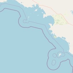
Map view of Murat Marine Park

Use this park location map to pinpoint Murat Marine Park in Australia, understand its exact geographic position, and read its mapped placement within the surrounding landscape more clearly.

Pigeon | © OpenStreetMap contributors

Location context for Murat Marine Park

South Australia
Park atlas

Compare adjacent marine reserves and surrounding coastal protected landscapes

Explore Other Parks Near Murat Marine Park and Protected Areas in the Region

Browsing parks near Murat Marine Park reveals broader ecological connections across the southern continental shelf. Comparing adjacent protected areas provides essential regional context for southern Australian marine habitats.
Nature reserveSouth Australia
About 57 km away#1 closest

North

Fowlers Bay Conservation Park: Coastal Protected Area and Regional Geography

A remote conservation landscape on the Great Australian Bight

Fowlers Bay Conservation Park stands as a vital protected area in South Australia, where vertical limestone cliffs meet horizontal chenopod plains. The park provides an essential look at the interaction between Southern Ocean maritime forces and the arid western Eyre Peninsula, offering a rare window into the transition zones of the Great Australian Bight coast.

Area
87.27 km²
Established
1993
IUCN
VI
Relief
Lowland
Nature reserveSouth Australia
About 58 km away#2 closest

North

Chadinga Conservation Park: Coastal Dunes and Salt Lake Geography in South Australia

Remote protected dune systems and arid saline landscapes

Chadinga Conservation Park protects a significant stretch of coastal dune country west of Lake MacDonnell. This arid landscape, defined by salt lakes and mallee scrub, serves as a crucial habitat for rare species, offering a raw and undisturbed look at the coastal geography of the South Australian coastline.

Area
118.54 km²
Established
1993
IUCN
VI
Relief
Lowland
Marine protected areaSouth Australia
About 89 km away#3 closest

Northwest

Great Australian Bight Marine National Park: Marine Protected Area Atlas and Geographic Context

Mapping the protected marine landscape of South Australia.

Delve into the geography and mapped boundaries of Great Australian Bight Marine National Park, a critical marine protected area located off the coast of South Australia. This resource provides an atlas-style view of the park, highlighting its geographic setting and significance as a protected marine environment. Understand the scope of this marine protected area and its place within the Australian geography, offering rich context for discovery and map exploration.

Area
1,233.22 km²
Established
1996
IUCN
II
Access
Access unknown
Nature reserveSouth Australia
About 93 km away#4 closest

North

Boondina Conservation Park: Protected Landscapes and Regional Geography in South Australia

A remote nature reserve within the Yellabinna mallee woodland network.

Boondina Conservation Park is a 125 square kilometre nature reserve in far western South Australia. It forms part of the expansive Yellabinna Reserves, buffering semi-arid mallee woodland environments and supporting regional ecological processes. This IUCN Category VI area stands out for its co-management with the Far West Coast Aboriginal Corporation and its role as a preserved natural landscape where traditional land use continues.

Area
125.55 km²
Established
1993
IUCN
VI
Relief
Lowland
Protected areaSouth Australia
About 150 km away#5 closest

East

Cape Blanche Conservation Park: Eyre Peninsula Coastal Protected Landscape Map

Regional geography and conservation coastal terrain

Located on the remote western coast of the Eyre Peninsula, Cape Blanche Conservation Park serves as a dedicated sanctuary for coastal raptors and migratory birds. This protected area features a rugged intersection of limestone cliffs, sandy bays, and native coastal flora, providing an essential ecological corridor within the South Australian reserve system.

Area
810 km²
Established
2012
IUCN
III
Scope
Terrestrial
Nature reserveSouth Australia
About 152 km away#6 closest

East

Eba Island Conservation Park: Coastal Landforms and Nature Reserve Geography in South Australia

A protected offshore sanctuary within Streaky Bay's coastal landscape.

Eba Island Conservation Park represents a key protected area within the coastal geography of South Australia. Composed primarily of calcarenite and limestone, the reserve features a diverse range of coastal landforms, including rugged jagged ridges, active blowholes, and sheltered coves, providing an essential habitat for seabird colonies.

Area
1.34 km²
Established
1966
IUCN
Ia
Relief
Lowland
Nature reserveSouth Australia
About 167 km away#7 closest

East

Calpatanna Waterhole Conservation Park: Protected Geography and Coastal Reserve Mapping

Nature reserve landscape within the South Australian Eyre Peninsula

Calpatanna Waterhole Conservation Park represents a specialized protected environment within South Australia. Centred on its namesake waterhole, the area preserves a distinctive mosaic of seasonal saline lagoons and hardy mallee eucalyptus scrub. This reserve highlights the ecological and geographic character of the Eyre Peninsula, where low undulating terrain supports unique, salt-adapted vegetation communities.

Area
36.44 km²
Established
1974
IUCN
Ia
Relief
Lowland
Wildlife reserveSouth Australia
About 218 km away#8 closest

East

Gawler Ranges Conservation Park: Mallee Landscapes and Regional Protected Areas

Semi-arid habitat and rocky terrain of South Australia

Gawler Ranges Conservation Park protects a core area of tree mallee woodland and rocky rises near the southern fringe of the Gawler Ranges. This wildlife reserve serves as an essential anchor for regional biodiversity on the Eyre Peninsula, offering a look at the arid-adapted vegetation and weathered geological structures that define this remote section of South Australia.

Area
154.8 km²
Established
1993
IUCN
VI
Relief
Upland

Common questions about visiting, size, designation, and location context for Murat Marine Park

Murat Marine Park FAQs for park facts, access, geography, and protected area context

Find quick answers about Murat Marine Park, including protected-area facts, park geography, trail and visitor context, and how the park fits into its surrounding country and regional landscape.
MoriAtlas Explorer

Continue Your Protected Areas Search Across the Global Atlas

Deepen your exploration by continuing the structured search for national parks and protected areas worldwide. Utilize the comprehensive filtering capabilities to compare different conservation landscapes and refine your understanding of global park geography. Discover more about the distribution and characteristics of protected natural areas.

Global natural geography