

Mori Atlas logo
Natural monumentNa cvičišti

Understanding the ecological mosaic and steppe habitats within this distinct Moravian geography

Na cvičišti Natural Monument: Mapping Protected Landscapes in the South Moravian Region

(Přírodní památka Na cvičišti)

Na cvičišti stands as a crucial protected natural monument located northeast of Mikulov, representing a deliberate conservation effort within the rolling, vineyard-dominated terrain of the South Moravian Region. This site preserves a rare mosaic of dry, steppe-like grasslands and early-successional habitats, which are the biological legacy of historical landscape disturbance. Its open, undulating terrain serves as a vital island for Pannonian flora and specialized butterfly species, showcasing how human-influenced land can evolve into a significant center for regional biodiversity.

dry grasslandssteppe habitatsearly-successional habitatsSouth MoraviaMikulovNatura 2000
Stylized digital illustration of a serene landscape with rolling green grasslands, colorful trees in shades of pink, yellow, and green, and a prominent rocky ridge in the background under a soft sunset sky.

Na cvičišti

Natural monument

Park overview

Structured park overview, official facts, and landscape profile for Na cvičišti

Na cvičišti park facts, protected area profile, and essential visitor context

Review the core facts for Na cvičišti, including designation, size, terrain, visitor scale, habitats, and operating context in one park-focused overview.

About Na cvičišti

Na cvičišti lies in the warm lowland landscape northeast of Mikulov, in the South Moravian part of the Czech Republic near the Austrian border. The protected area covers roughly 55 hectares and represents one of the regional expressions of the historically significant Pannonian-influenced dry grasslands that occur in this part of Moravia.

Although small, the site is ecologically distinctive because of how it was formed. From the 1950s onward, the land was used as a military zone called Cvičiště B. Repeated disturbance prevented the area from closing into dense woodland and instead maintained a shifting patchwork of open, dry, and early-successional habitats. After military activity ended, this disturbance-driven mosaic was recognized as a conservation asset rather than a degraded landscape.

In 2016, the locality was formally declared a přírodní památka, a natural monument under Czech nature protection law, and was simultaneously incorporated into the Natura 2000 ecological network. The combination of national protection and Natura 2000 status underscores that the site is valued not only for its local biodiversity but also within a broader European conservation framework.

The mosaic character is central to the park's identity. Broad-leaved dry grasslands, steppic glades, and ruderal vegetation alternate with shrub patches and fragmented woody stands. This structural diversity creates niches for a wide range of organisms, from rare flowering plants to thermophilic butterflies and ground-nesting birds. As a result, despite its modest area, Na cvičišti punches well above its weight for species richness and conservation relevance.

Quick facts and research context for Na cvičišti

Na cvičišti is a Czech natural monument (přírodní památka) of IUCN management category IV, designated as a habitat and species management area. It lies northeast of Mikulov, in the Břeclav District of the South Moravian Region, and covers an area of around 55 hectares.

The site is part of the Natura 2000 network and was formally protected in 2016 after earlier military use ended. Its protected features are the rare plant and animal communities associated with dry grasslands, steppic glades, ruderal vegetation, and early-successional habitats, supplemented by scattered shrub and tree growth.

Protection and recognition

Documented protection timeline and territorial management context for Na cvičišti

Na Cvičišti Protection Status and Designated Terrestrial Conservation History

Terrestrial protection status for Na cvičišti is officially recorded from the designated establishment year of 2016. Official records outline the baseline conservation scope and historical management context established for the protected landscape.

Protection details

Protection scope
Terrestrial
Designated year
2016
Park context

Deeper park guide and search-rich context for Na cvičišti

Na cvičišti history, landscape, wildlife, and travel context

Explore Na cvičišti through its history, landscape character, ecosystems, wildlife, conservation priorities, cultural context, and seasonal travel timing in a structured park guide built for atlas discovery and search intent.

Why Na cvičišti stands out

The site is best known for its unusually rich mosaic of dry, steppe-like grasslands and early-successional stages that developed on a former military training ground. This disturbance-driven habitat mosaic supports a high concentration of rare and protected species, including more than 300 recorded plant species and a butterfly fauna in which over a third of the species are protected.
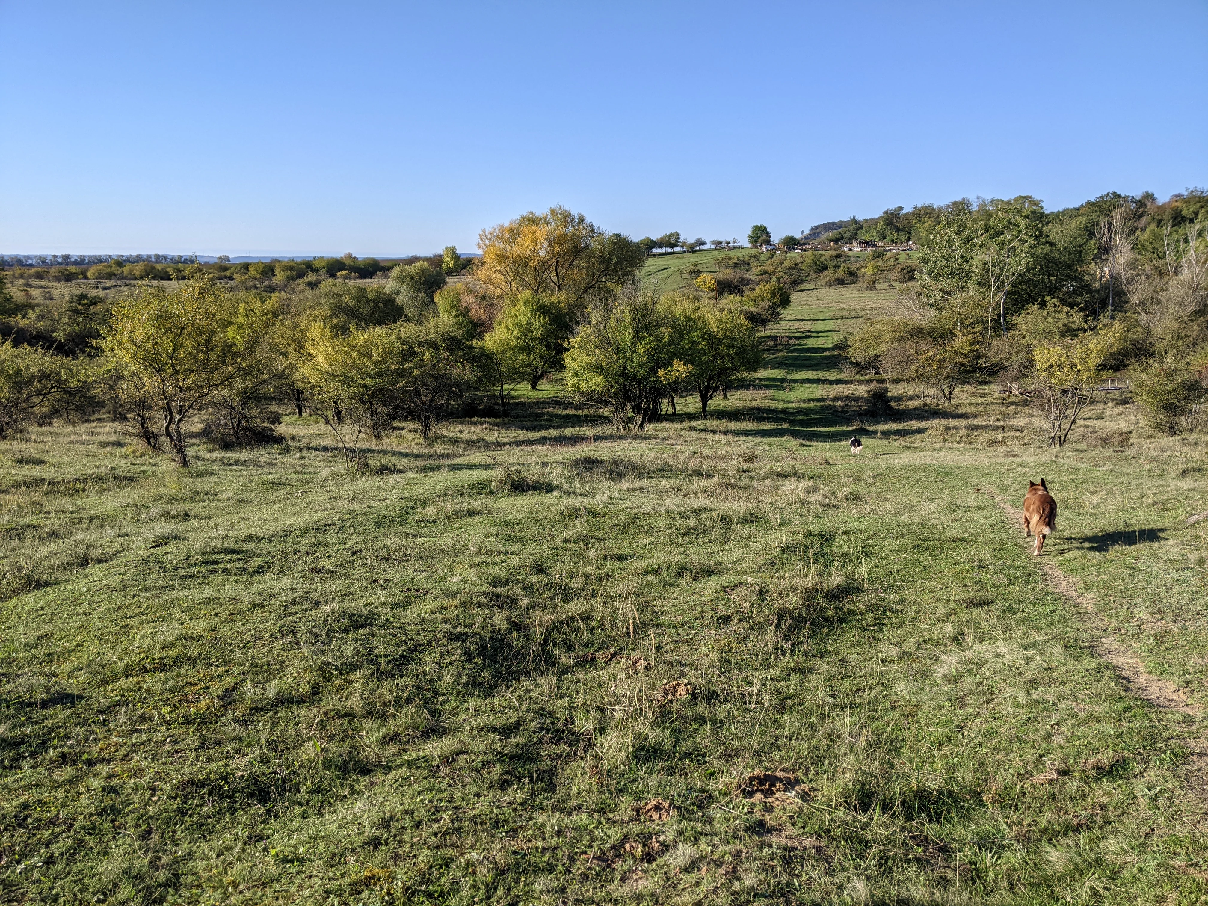
A wide shot of a grassy, slightly uneven hillside in Na cvičišti with scattered deciduous trees and shrubs under a clear blue sky. A brown dog is walking along a faint trail in the mid-right foreground.
A dog walking along a trail through the Na cvičišti natural monument, featuring a mosaic of dry grasslands and scattered trees.

Na cvičišti history and protected-area timeline

The history of Na cvičišti is closely tied to its long use as a military training ground, known locally as Cvičiště B, which began in the 1950s. During the Cold War era, military activity kept the landscape open, disturbed, and unsuitable for ordinary agricultural intensification or reforestation.

Over decades, this ongoing disturbance shaped an unusual habitat mosaic. Tracked vehicles, foot traffic, and recurrent clearances prevented woody plants from dominating and instead preserved a shifting patchwork of dry grassland, bare ground, ruderal vegetation, and scattered shrubs. Although the original military purpose was unrelated to nature conservation, the ecological side effect was a landscape of high value for species that depend on open, dry, sun-exposed conditions.

When military use of the territory ended, the area was recognized as a conservation priority. In 2016 it was officially declared a přírodní památka, and it was also integrated into the Natura 2000 network, placing its protection within both Czech and European frameworks.

Na cvičišti landscape and geographic character

Na cvičišti occupies part of the warm, low-lying Moravian countryside northeast of Mikulov, in a region with strong Pannonian climatic influence. The terrain is gently undulating and lies well below any true mountain or alpine character, instead belonging to the rolling agricultural and vineyard landscapes of southern Moravia.

What sets the site apart is not dramatic relief but the texture of its surface. The ground is broken into a fine mosaic of dry, sun-exposed open areas, patches of low grassy vegetation, stony or bare substrates, shrub clusters, and fragments of woody regrowth. There are no major rivers, cliffs, or large water bodies within the protected area; instead, the landscape's value lies in its openness and microhabitat variability.

Surrounding land use is dominated by agriculture and the vineyards typical of the Mikulov region. Within that context, the protected site stands out as a deliberately preserved island of dry, semi-natural habitat where the ground remains visible, the soil is largely intact, and the vegetation stays short and patchy rather than closed into forest.

Na cvičišti ecosystems, habitats, and plant life

Ecologically, Na cvičišti is defined by the interaction of dry grassland, steppic, ruderal, and early-successional communities. Broad-leaved dry grasslands, steppic glades, and ruderal vegetation form the core vegetation cover, with scattered shrubs and small woody stands adding structural variation rather than dominating the site.

The plant communities are unusually species-rich for such a small area. More than 300 plant species have been recorded, including characteristic grasses such as Brachypodium pinnatum and Dactylis glomerata, alongside steppic and dry-grassland specialists like Adonis vernalis, Stipa pennata, Thesium dollineri, and Inula ensifolia. The combination of grasses, herbs, and low-growing steppic flora gives the site a distinctly southern, open-country character.

A defining feature of the site is that this vegetation mosaic is dynamic. Early-successional stages and disturbed patches coexist with older dry-grassland stands, creating a constantly shifting pattern of microhabitats. That dynamism, originally driven by military activity and now maintained by management, is what allows so many specialized species to coexist in a relatively small area.

Na cvičišti wildlife and species highlights

Wildlife at Na cvičišti reflects the open, dry, mosaic structure of the habitat. The site supports a particularly notable butterfly fauna: 66 species of day-flying butterflies have been recorded, and more than a third of them are protected. Species of conservation interest include Polyommatus daphnis and Thymelicus sylvestris, alongside a range of saproxylic and thermophilic insects such as the jewel beetle Anthaxia podolica and the ground beetle Calosoma sycophanta. The rare moth Eriogaster catax and oil beetles of the genus Meloe have also been documented.

The mosaic of open grassland and shrubby patches is equally important for birds. Species such as the corn bunting (Emberiza calandra) and the barred warbler (Sylvia nisoria) regularly breed here, both being associated with open or semi-open landscapes rather than closed forest. Their presence is itself an indicator of the habitat quality being maintained.

Taken together, the insect and bird communities make the site disproportionately valuable for its size. The combination of rare butterflies, saproxylic beetles, specialized moths, and ground-nesting birds tied to shrubby mosaics is characteristic of high-quality dry-grassland landscapes and is one of the main reasons the area is protected.

Na cvičišti conservation status and protection priorities

Conservation at Na cvičišti centers on safeguarding the specific mosaic of dry grasslands, steppic vegetation, and early-successional habitats that support the site's rare flora and fauna. The area is designated as a přírodní památka, a Czech natural monument classification that focuses on protecting particular natural features such as habitat mosaics and species-rich communities.

Its inclusion in the Natura 2000 network places the site within a wider European conservation framework, recognizing that its dry, sun-exposed habitat mosaic and its assemblages of butterflies, plants, and birds are of significance beyond the Czech Republic. Natura 2000 status also implies that the habitats and species for which the site is listed must be maintained in favorable condition.

The broader conservation value of the site is tightly linked to historical disturbance. Without continued management, the open, dry character would gradually be lost to shrub encroachment and reforestation, which would in turn erase the habitat conditions on which the rare species depend. Maintaining openness and habitat diversity is therefore the core conservation challenge, and active management is implicit in the site's protected designation.

Na cvičišti cultural meaning and human context

Na cvičišti does not center on a strong cultural or ethnographic narrative. The site's identity is shaped primarily by its ecological history rather than by human settlement or traditional land use. Even so, the name itself reflects a specifically military-cultural past: the area is called Cvičiště, meaning training ground, after decades of use by the armed forces from the 1950s onward.

The surrounding region around Mikulov is well known in Czech culture for its wine-making tradition, historic architecture, and Pannonian-influenced landscape character. The protected site sits within that broader regional context but is valued for its natural qualities rather than for any built or traditional cultural features. There is no notable indigenous or community-based stewardship narrative attached to the site, so a deeper cultural interpretation would not be well grounded in the available sources.

Top sights and standout views in Na cvičišti

The site's most distinctive highlight is that its ecological richness is the direct legacy of long-term military disturbance, which prevented forest closure and maintained an open mosaic of dry grassland and early-successional stages. This unusual origin story makes Na cvičišti an example of how disturbance-driven landscapes can become conservation assets when managed appropriately.

Equally notable is the site's biological concentration: more than 300 recorded plant species and 66 butterfly species, including a high proportion of protected taxa, packed into a protected area of roughly 55 hectares. The presence of steppic specialists such as Stipa pennata and Adonis vernalis, alongside protected birds like Sylvia nisoria and Emberiza calandra, makes the site a compact but exceptionally representative example of South Moravian dry-grassland biodiversity.

Best time to visit Na cvičišti

As a protected natural monument rather than a developed visitor destination, Na cvičišti is best appreciated through its seasonal character rather than through specific tourist seasons. Late spring and early summer generally bring the most expressive display of the dry grasslands and steppic flora, when grasses and characteristic herbs such as Adonis vernalis and Inula ensifolia are in active growth.

Summer is also the most productive period for observing butterflies and other insects, which are a major part of the site's conservation value. Early mornings and warm, settled weather tend to bring out the greatest variety of butterfly activity. Outside the growing season, the site retains its open, mosaic character but loses much of its visible flowering and insect interest, making late spring through mid-summer the most rewarding window for a visitor interested in the area's natural features.


Monthly climate preview

Long term monthly averages and precipitation rhythms across the protected area coordinate

Na cvičišti Climate Normals and Measured Annual Temperature Patterns

Representative coordinates record sustained temperature shifts and monthly precipitation variations from recorded baseline climatology. Detailed twelve month comparisons offer complete access to average minimum and maximum readings for Na cvičišti.
Annual mean9 °C
-3 °C21 °C
Jan-3°
Feb-1°
Mar
Apr
May15°
Jun19°
Jul21°
Aug21°
Sep15°
Oct
Nov
Dec-2°
Warmest month
July

21 °C

Coolest month
January

-2.7 °C

Wettest month
June

2.4 mm/day

Driest month
February

1.1 mm/day

Park location guide

Geography guide, regional context, and park location map for Na cvičišti

Na cvičišti park geography, regions, and map view in Czechia

Understand where Na cvičišti sits in Czechia through a broader geographic reading of the surrounding landscape, nearby location context, and its mapped position within the national park landscape.

How Na cvičišti fits into Czechia

Czech Republic is a landlocked Central European country with a population of approximately 10.9 million people. The nation was established as an independent state on January 1, 1993, following the dissolution of Czechoslovakia. Its capital and largest city is Prague, with other major urban centers including Brno, Ostrava, Plzeň, and Liberec.

Wider geography shaping Na cvičišti in Czechia

The Czech Republic is a landlocked country in Central Europe. It is bordered by Germany to the west, Austria to the south, Poland to the northeast, and Slovakia to the southeast. The landscape is predominantly hilly, with the territory covering 78,871 square kilometers.

Map view of Na cvičišti

Use this park location map to pinpoint Na cvičišti in Czechia, understand its exact geographic position, and read its mapped placement within the surrounding landscape more clearly.

Pigeon | © OpenStreetMap contributors

Location context for Na cvičišti

South Moravian Region

Visual reference for dry grasslands, terrain texture, and Pannonian flora

Na cvičišti Landscape Photography: Scenery and Protected Habitats

Visual documentation captures the undulating terrain, sun-exposed open areas, and rare dry-grassland vegetation that define the protected landscape. Examining photographic records reveals the fine mosaic of low grassy patches and shrub clusters shaped by historical land use.

A wide shot of a grassy, slightly uneven hillside in Na cvičišti with scattered deciduous trees and shrubs under a clear blue sky. A brown dog is walking along a faint trail in the mid-right foreground.

Park atlas

Compare regional protected landscapes and neighboring reserves in southern Moravia

Explore Protected Areas and Other Parks Near Na cvičišti

Visitors exploring Na cvičišti can continue browsing nearby protected areas and regional reserves across the surrounding landscape. Comparing adjacent lowland habitats and dry grasslands provides broader context for South Moravian conservation geography.
Natural monumentJihomoravský kraj
About 33 km away#1 closest

North

Velké Družďavy Natural Monument: Steppe Geography and Protected Landscapes in Jihomoravský kraj

Rare xerothermic habitats on Miocene sandy substrates

Velké Družďavy represents a vital, small-scale protected area in the Czech Republic. Defined by its south-facing slope and sandy Miocene substrate, the site supports significant populations of thermophilic plants. This natural monument illustrates the challenges of managing xerothermic steppe vegetation against encroaching forest succession, providing a distinct geographic focal point within the regional protected area network of South Moravia.

Area
0.014 km²
Established
1953
IUCN
IV
Relief
Upland
Protected landscapeCzechia
About 34 km away#2 closest

Northeast

Přírodní park Ždánický les: Exploring Protected Woodlands and Moravian Carpathian Landscapes

Regional woodland geography and floodplain meadow systems

Přírodní park Ždánický les spans nearly 182 square kilometers of rolling terrain across the Vyškov and Hodonín districts. This protected landscape preserves extensive broadleaf forests, including mature beech and oak stands, while maintaining unique floodplain meadows that serve as essential habitat corridors within the wider Moravian Carpathian region.

Area
181.89 km²
Established
1996
Relief
Upland
Scope
Terrestrial
A horizontal watercolor illustration showing rolling green hills and meadows against a soft, pale background, with trees and soft light.
Protected landscapeBrno-venkov District
About 40 km away#3 closest

Northwest

Přírodní park Bobrava Protected Landscape: Geography and Regional Mapping

South Moravian forest and river valley terrain

Přírodní park Bobrava represents an unbroken, forest-heavy landscape situated in the Brno-venkov District. Characterized by its deep river valleys and hilly ridges, this protected territory functions as a crucial natural mosaic of woodlands and meadows, providing a quiet highland retreat that remains distinct from the surrounding urban expansion of the city of Brno.

Area
30.9 km²
Established
1982
Relief
Upland
Climate
Temperate
Natural monumentJihomoravský kraj
About 42 km away#4 closest

North

Velatická slepencová stráň: A Protected Natural Monument in South Moravia, Czech Republic

Mapping the rare steppe vegetation and conglomerate geology of Jihomoravský kraj.

Velatická slepencová stráň serves as a critical refuge for thermophilous steppe communities within the Jihomoravský kraj region. The site features distinctive conglomerate outcrops and a rich assembly of dry-grassland plants. This mapping resource provides a comprehensive geographic overview of the protected landscape and its specific ecological configuration.

Area
0.017 km²
Established
1951
IUCN
IV
Relief
Upland
A watercolor painting showing a stylized, panoramic view of green rolling hills and evergreen trees under a soft, light-colored sky.
Nature reserveJihomoravský kraj
About 42 km away#5 closest

Northwest

Rybičková skála Nature Reserve: Paleontological and Geological Landscape in Jihomoravský kraj

A preserved Permian fossil site in the Boskovice Furrow

Rybičková skála acts as a vital reference point for Permian sedimentary studies in central Europe. The site features a 40 meter cliff exposing mudstones and siltstones rich in fish fossils. Framed by mixed oak-hornbeam forests and rural Moravian farmland, this compact reserve represents a convergence of deep geological time and traditional landscape character.

Area
0.001 km²
Established
1980
IUCN
III
Relief
Upland
Nature reserveJihomoravský kraj
About 44 km away#6 closest

Northeast

Volkramy Nature Reserve: Geography and Protected Habitat Mapping in South Moravia

Sub-Pannonian steppe grassland and sandy landscape terrain.

Volkramy serves as a critical nature monument in the Czech Republic, protecting a dense concentration of rare steppe flora and dry-grassland ecosystems on sandy substrates. This protected area within the Jihomoravský kraj region showcases a unique combination of open grassland, orchard heritage, and post-industrial sand quarry habitats that provide nesting sites for specialized bird colonies.

Area
0.072 km²
Established
2023
IUCN
IV
Relief
Upland
Nature reserveJihomoravský kraj
About 44 km away#7 closest

North

Velká Klajdovka Nature Reserve: Steppe and Forest-Steppe Landscape in Jihomoravský Kraj

Ecologically rich protected limestone slopes and terrain near Brno

Velká Klajdovka is a protected natural monument distinguished by its high-value thermophilic vegetation and complex soil structures. Located on the flank of the Hády massif, the reserve offers a unique study of forest-steppe mosaics, rare entomological diversity, and dry oak woodlands that thrive on the boundary of varied geological substrates.

Area
0.09 km²
Established
1988
IUCN
IV
Relief
Upland
A watercolor painting showing a soft, stylized landscape of rolling hills, a central body of water, and small shrubs in the foreground, all set against a white background.
Natural monumentSouth Moravian Region
About 44 km away#8 closest

West

Mikulovické jezero Natural Monument: Geographic Boundaries and Wetland Atlas

A rare upland basin in the South Moravian Region

Mikulovické jezero represents a significant natural monument in the South Moravian Region. This unique upland basin, formed in a plateau depression, serves as a crucial refuge for specialized wetland species and rare halophilic vegetation. Explore the geographic footprint of this precipitation fed lake and its surrounding habitat structures within the Znojmo District.

Area
0.027 km²
Established
1999
IUCN
IV
Relief
Lowland

Common questions about visiting, size, designation, and location context for Na cvičišti

Na cvičišti FAQs for park facts, access, geography, and protected area context

Find quick answers about Na cvičišti, including protected-area facts, park geography, trail and visitor context, and how the park fits into its surrounding country and regional landscape.
MoriAtlas Explorer

Continue Your Protected Areas Search Across the Global Atlas

Deepen your exploration by continuing the structured search for national parks and protected areas worldwide. Utilize the comprehensive filtering capabilities to compare different conservation landscapes and refine your understanding of global park geography. Discover more about the distribution and characteristics of protected natural areas.

Global natural geography