Mori Atlas logo
Natural monumentNa Stříbrné

Geological diversity meets rich beech forest habitats within the Czech upland terrain.

Na Stříbrné Natural Monument: Exploring Protected Woodland Landscapes in Středočeský kraj

(Přírodní památka Na Stříbrné)

Na Stříbrné serves as a compact but vital natural monument within the hilly landscape of the Středočeský kraj. This reserve preserves a distinct intersection of metamorphosed limestone, dolomite, and granite substrates that support specialized beech forest flora. Beyond its botanical significance, the area functions as a key habitat for bat populations, utilizing historical mining adits that reflect the region's long-standing industrial and natural heritage.

beech forestflower-rich forestDaphne mezereumsmall nature reservenatural monumentCentral Bohemia

Na Stříbrné

Natural monument

Park overview

Structured park overview, official facts, and landscape profile for Na Stříbrné

Na Stříbrné park facts, protected area profile, and essential visitor context

Review the core facts for Na Stříbrné, including designation, size, terrain, visitor scale, habitats, and operating context in one park-focused overview.

About Na Stříbrné

Na Stříbrné is a protected natural monument in the Central Bohemian Region of the Czech Republic, situated on a forested slope near the historic village of Český Šternberk. Despite its very small size of less than five hectares, the reserve concentrates a remarkable variety of natural and historical features within easy walking distance. Its identity rests on three intersecting themes: a botanically rich beech woodland, a geologically diverse bedrock, and a network of small-scale historical mining works.

The forest belongs to the květnatá bučina type, a Central European beech forest that is renowned for its seasonal diversity of herbs and shrubs in the understory. Within this woodland, the shrub layer is dominated in places by Daphne mezereum, which gives the site much of its botanical reputation. The plant flowers early, before the beech canopy fully leafs out, and its red berries later in the year are visually prominent. Surveys in the early 2000s counted roughly 120 shrubs, including individuals just outside the strict reserve boundary, indicating that the population extends across the surrounding landscape rather than being confined to a few clusters.

The site's geological interest is unusually high for such a compact area. Researchers have documented several bedrock types in close proximity, including dolomitic marble derived from metamorphosed limestone and dolomite, pararula (a gneiss-like metamorphic rock), amphibolite, and granite. This diversity produces subtle variations in soil chemistry and moisture, which in turn support the heterogeneity of the forest floor flora. The geological character also left a tangible mark on the landscape: marble was quarried in the northwestern part of the present protected area in the 19th century, and the broader region is associated with historical silver mining, reflected in the reserve's name, which translates roughly as "At the Silver (place)."

In addition to its botanical and geological values, Na Stříbrné has an important zoological component. Along its northern boundary lies the drainage adit of the Malovidy ore body, a former polymetallic deposit where lead, zinc, and copper ores were once extracted. This mine adit, together with associated underground workings, now provides significant roosting habitat for bats, giving the site an additional conservation dimension rooted in its mining heritage. The combination of forest, bedrock, and abandoned mining infrastructure means that the reserve functions almost as an outdoor laboratory for understanding how geological and human history shape local biodiversity.

Quick facts and research context for Na Stříbrné

Na Stříbrné is classified as a přírodní památka (natural monument), a category corresponding broadly to IUCN Category IV, a habitat or species management area. It lies within the Středočeský kraj (Central Bohemian Region) and the Benešov okres (district), immediately adjacent to the historically significant village of Český Šternberk along the Sázava river valley. The protected area occupies roughly 4.82 hectares, with elevations from about 320 to 382 meters above sea level, on terrain shaped by both natural forest dynamics and small-scale historical mineral extraction.

The site's main conservation focus is a květnatá bučina (flower-rich beech forest), supplemented by protection of Daphne mezereum shrubs and notable large fungi, including more than 15 Red List species. The reserve is also recognized for the drainage adit of the former Malovidy ore body, which serves as an important bat roost. Geologically, the area combines dolomitic marble, paragneiss-like pararula, amphibolite, and granite, offering a compact cross-section of regional bedrock types.

Park context

Deeper park guide and search-rich context for Na Stříbrné

Na Stříbrné history, landscape, wildlife, and travel context

Explore Na Stříbrné through its history, landscape character, ecosystems, wildlife, conservation priorities, cultural context, and seasonal travel timing in a structured park guide built for atlas discovery and search intent.

Why Na Stříbrné stands out

Na Stříbrné is best known for its flower-rich beech forest harboring a notable population of Daphne mezereum (mezereon), a poisonous shrub with conspicuous berries and early-spring flowers. Around 120 shrubs of this species were recorded during a 2003 survey, making the reserve a regionally significant locality for the plant. The site is equally recognized for its geologically diverse substrate in a very small footprint, where metamorphosed limestone, dolomite, amphibolite, and granite meet directly beneath the forest. This unusual combination, together with traces of 19th-century limestone quarrying, gives the protected area a layered character that blends ecological, geological, and historical-mining heritage into one compact site.
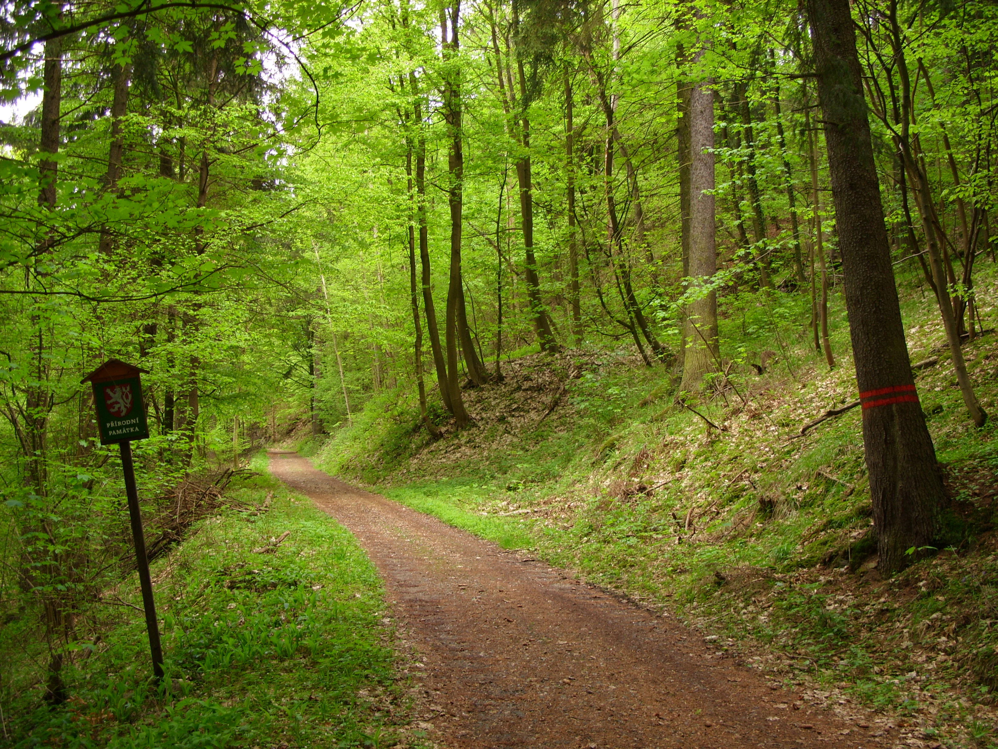
A dirt hiking trail leads into a lush, green deciduous forest at the Na Stříbrné natural monument, with a small park signage post on the left.
The southwest entrance to Na Stříbrné natural monument, marked by a hiking trail sign and a forest boundary indicator.

Na Stříbrné history and protected-area timeline

The protected status of Na Stříbrné was formally established on 9 March 1972, when the area was declared a přírodní památka (natural monument) under Czechoslovak nature conservation law. The designation reflected recognition of the site's outstanding local natural values, particularly its flower-rich beech forest and the presence of Daphne mezereum.

Although the formal protection is relatively recent in conservation terms, the landscape itself bears much older marks of human activity. In the 19th century, dolomitic marble was quarried in the northwestern part of what is now the reserve, exploiting the metamorphosed limestone that is one of the defining geological features of the site. The broader region around Český Šternberk also has a tradition of silver mining, and the reserve's name, "Na Stříbrné," hints at this mineral past. In addition, the Malovidy deposit, a polymetallic ore body of contact-metasomatic origin, was historically worked for galenite, sphalerite, and tetrahedrite, and its drainage adit now lies along the northern boundary of the protected area.

Since its designation, the reserve has been the subject of targeted botanical inventories, including a 2003 plant survey that documented approximately 120 Daphne mezereum shrubs inside and just outside the reserve boundaries, and that also recorded a substantial number of large fungi, more than fifteen of which appear on the Czech Red List of fungi. These surveys underpin the continuing recognition of the site as a small but unusually rich natural monument.

Na Stříbrné landscape and geographic character

Na Stříbrné occupies a hilly, forested segment of the Central Bohemian landscape, with elevations ranging from roughly 320 to 382 meters above sea level. The terrain is part of the broader dissected upland along the Sázava river corridor, near the historic settlement of Český Šternberk. Steep wooded slopes, shaded ravines, and intimate valleys give the area a varied microtopography despite the very small total area of the protected zone.

The slope profile and forest cover combine with the underlying rock types to produce strongly localized contrasts in ground conditions. Weathering of the dolomitic marble yields calcareous, base-rich substrates in some spots, while granitic and amphibolitic outcrops contribute more acidic, nutrient-poor patches. These differences, compressed into a few hectares, support a patchwork of forest microhabitats and give the site much of its landscape distinctiveness within the region.

Na Stříbrné ecosystems, habitats, and plant life

The reserve protects a representative example of a květnatá bučina, a Central European flower-rich beech forest. This forest type is characterized by a closed canopy of European beech, beneath which a diverse herb and shrub layer thrives in the bright light of early spring before the leaves fully expand. The beech stands at Na Stříbrné are relatively mature and structurally varied, creating the shaded but seasonally dynamic conditions favored by many woodland specialists.

The most celebrated element of the forest is its population of Daphne mezereum, a deciduous shrub whose pinkish, fragrant blooms appear very early in spring and whose red berries persist into summer. Around 120 individuals were recorded during a 2003 inventory, indicating that the species is well established in the local beech forest mosaic.

The understory and forest floor also support an unusually diverse mycological community. Surveys of the site have recorded numerous species of large fungi, more than fifteen of which are included in the Czech Red List of fungi, underlining the conservation importance of the woodland for organisms beyond the vascular plants. Variation in bedrock chemistry, slope, and humidity across such a compact area is widely thought to underlie this richness, reinforcing the reserve's role as an ecological hotspot at the local scale.

Na Stříbrné wildlife and species highlights

Although the reserve is small, it supports notable wildlife, particularly in its underground and forest-floor habitats. The most distinctive faunal feature is associated with the old drainage adit of the Malovidy ore deposit along the northern boundary. This adit provides a sheltered, stable microclimate that is highly valued by bats, and the mine workings as a whole constitute a significant bat roosting site within the wider region.

Above ground, the mature beech forest provides habitat for typical woodland fauna. The structurally diverse canopy and the mosaic of microhabitats created by different bedrock types support an array of invertebrates, fungi-dependent species, and smaller woodland mammals typical of Central Bohemian forests. The combination of mature woodland, dead wood, mineral substrates, and nearby aquatic and riparian habitats associated with the Sázava valley gives the reserve, despite its modest size, a broader ecological reach than its footprint alone would suggest.

Na Stříbrné conservation status and protection priorities

As a přírodní památka (natural monument), Na Stříbrné is managed primarily to safeguard specific features rather than to maintain a large-scale ecosystem. The conservation objectives focus on the flower-rich beech forest, the population of Daphne mezereum, the rich macrofungal community, and the bat roosts in the historic Malovidy adit. The site's profile on national conservation lists, along with the Red List status of many of its fungi, underscores the importance of these specific features at the regional level.

The presence of geological diversity within a few hectares adds another layer of conservation significance. The juxtaposition of marble, pararula, amphibolite, and granite means that the site preserves a small but unusually complete record of the regional bedrock, which in turn supports the mosaic of soils and habitats that underpin its biological richness. Protecting this combination requires careful management of forest structure, retention of dead wood, and avoidance of disturbance to the adit and its bat fauna.

Na Stříbrné cultural meaning and human context

The landscape around Na Stříbrné has been shaped by human activity for centuries, and the reserve itself carries visible traces of that history. The most prominent cultural anchor is the nearby village of Český Šternberk, renowned for its medieval castle perched above the Sázava river and for its long-standing role in the regional life of Central Bohemia.

Within the protected area, small-scale mineral extraction has left a quieter but distinct mark. Marble quarrying in the 19th century exploited the dolomitic bedrock of the site, while the Malovidy polymetallic deposit, worked historically for lead, zinc, and copper ores, introduced the drainage adit that today supports bat colonies. The regional tradition of silver mining is reflected simply in the reserve's name, "Na Stříbrné," which evokes the broader mining heritage of the Sázava valley. Together, these elements place the natural monument within a cultural landscape where forest, geology, and mining history are closely intertwined.

Top sights and standout views in Na Stříbrné

Several themes converge to give Na Stříbrné its distinctive character. The flower-rich beech forest, with its well-documented population of Daphne mezereum, anchors the botanical interest of the site. The diverse geology, with marble, pararula, amphibolite, and granite all present within a few hectares, offers a compact geological showcase unusual for so small an area. The Malovidy drainage adit, a relic of historical polymetallic mining, adds a significant bat roost to the conservation profile of the reserve. The wider setting, close to the historic village and castle of Český Šternberk, situates these natural values within a culturally rich Central Bohemian landscape.

Best time to visit Na Stříbrné

The character of Na Stříbrné changes meaningfully with the seasons, largely because of the forest type and the phenology of its key species. In early spring, before the beech canopy fully closes, the Daphne mezereum shrubs come into bloom, producing a fresh, bright understory in the still-open woodland. By late spring and early summer, the beech leaves create a deep, shaded forest interior, while summer and early autumn bring the peak of fungal activity that has made the reserve locally famous among mycologists.

Autumn is therefore a particularly rewarding time for visitors interested in the site's fungi and in the warm seasonal colors of the beech forest. In winter, the bare deciduous structure of the woodland reveals the topography more clearly and offers a quieter, more contemplative experience of the reserve. Because the site is small and largely forested, visits in any season can be brief, but timing a visit to coincide with flowering Daphne mezereum in early spring or peak mushroom season in autumn tends to bring out the most distinctive features.

Monthly climate preview

Long-term monthly temperature averages and precipitation statistics for Na Stříbrné

Na Stříbrné Climate Normals and Measured Annual Temperature Patterns

Representative coordinates record measured temperature swings alongside steady precipitation rhythms across twelve distinct intervals. Detailed monthly records reveal full thermal variation and precipitation baselines for advanced geographical analysis.
Annual mean9 °C
-2 °C20 °C
Jan-2°
Feb-1°
Mar
Apr
May14°
Jun18°
Jul20°
Aug19°
Sep14°
Oct
Nov
Dec-1°
Warmest month
July

19.8 °C

Coolest month
January

-2.5 °C

Wettest month
July

2.7 mm/day

Driest month
April

1.2 mm/day

Park location guide

Geography guide, regional context, and park location map for Na Stříbrné

Na Stříbrné park geography, regions, and map view in Czechia

Understand where Na Stříbrné sits in Czechia through a broader geographic reading of the surrounding landscape, nearby location context, and its mapped position within the national park landscape.

How Na Stříbrné fits into Czechia

Czech Republic is a landlocked Central European country with a population of approximately 10.9 million people. The nation was established as an independent state on January 1, 1993, following the dissolution of Czechoslovakia. Its capital and largest city is Prague, with other major urban centers including Brno, Ostrava, Plzeň, and Liberec.

Wider geography shaping Na Stříbrné in Czechia

The Czech Republic is a landlocked country in Central Europe. It is bordered by Germany to the west, Austria to the south, Poland to the northeast, and Slovakia to the southeast. The landscape is predominantly hilly, with the territory covering 78,871 square kilometers.

Map view of Na Stříbrné

Use this park location map to pinpoint Na Stříbrné in Czechia, understand its exact geographic position, and read its mapped placement within the surrounding landscape more clearly.

Pigeon | © OpenStreetMap contributors

Location context for Na Stříbrné

Středočeský kraj

Explore the terrain, woodland flora, and protected area environment through detailed visual records.

Na Stříbrné Photos and Landscape Scenery: Visualizing the Protected Forest Habitat

Visual records reveal the steep wooded slopes, flower-rich beech forest, and geological diversity defining Na Stříbrné within the Central Bohemian landscape. Examining these protected area images provides a clearer understanding of the terrain, forest habitats, and microtopography shaping the reserve.

A dirt hiking trail leads into a lush, green deciduous forest at the Na Stříbrné natural monument, with a small park signage post on the left.

Park atlas

Compare regional park geography and adjacent protected landscapes across Central Bohemia

Explore Parks Near Na Stříbrné and Surrounding Protected Natural Areas

Continue geographic discovery beyond Na Stříbrné by browsing other protected areas and woodland reserves situated throughout the surrounding Central Bohemian uplands. Comparing nearby park terrain reveals broader ecological patterns and regional conservation contexts across the Sázava river corridor.
Natural monumentStředočeský kraj
About 8.6 km away#1 closest

South

Na ostrově Natural Monument: Protected Juniper Habitats in Středočeský kraj, Czech Republic

Geographic landscape profile and ecological monument overview

Investigate the natural terrain and conservation value of Na ostrově, a protected site in the Benešov District. This area preserves a rare juniper-dominated hillside, offering insight into dry grassland and heath ecosystems maintained through traditional pastoral management.

Area
0.05 km²
Established
1972
IUCN
IV
Relief
Upland
Natural monumentJihočeský kraj
About 12 km away#2 closest

South

Vlašimská Blanice Natural Monument: Mapped River Geography and Protected Valley Terrain

A vital riverine habitat in the South Bohemian Region

Vlašimská Blanice forms a protected natural monument around an unregulated, meandering section of the Blanice River. This landscape is defined by its continuous riparian woodland, gravel-rich riverbed structures, and a surrounding mosaic of floodplains and meadows, providing essential habitat continuity within the Jihočeský kraj terrain.

Area
0.304 km²
Established
2014
IUCN
III
Relief
Upland
Watercolor painting of a peaceful wetland landscape with a pond, tall grasses, rolling hills, and a soft, muted color palette.
Natural monumentCentral Bohemia Region
About 24 km away#3 closest

South

Rybník Louňov Natural Monument: Mapped Geography and Protected Wetland Ecosystems

Central Bohemia Region protected wetland and pond habitat

Rybník Louňov serves as a protected natural monument defined by its intimate mosaic of open water, emergent reed beds, and wet meadow patches. Located in the Central Bohemia Region, this site provides a critical refuge for rare flora and fauna, illustrating the role of small-scale landscape preservation in maintaining regional ecological health.

Area
0.019 km²
Established
2001
IUCN
IV
Relief
Lowland
Natural monumentStředočeský kraj
About 24 km away#4 closest

Southwest

Roudný Natural Monument: Mapping Protected Mining Habitats in Středočeský Kraj

Explore the geography of this rare sandy sanctuary for invertebrates and fungi.

Roudný is a specialized natural monument protecting the sandy, nutrient-poor substrate of a former gold mine. The site stands as a significant biological island in Středočeský kraj, supporting species dependent on open, eroded sandy slopes that are now rare in the wider regional landscape. Its compact geography highlights the intersection of industrial history and conservation in the Czech Republic.

Area
0.025 km²
Established
1994
IUCN
IV
Relief
Lowland
A horizontal watercolor illustration of a gentle, rolling landscape with green fields, patches of forest, and faint pink floral accents in the foreground.
Protected landscapeBenešov District
About 25 km away#5 closest

Southwest

Přírodní park Džbány-Žebrák: Geography and Protected Area Landscape Map

Mapping the forests and meadows of the Benešov District

Přírodní park Džbány-Žebrák offers a distinct look into the central Bohemian uplands, marked by gentle ridges and spring-fed valleys. This protected area supports an interconnected web of small ponds, damp woodland clearings, and rural agricultural mosaics. Use this resource to trace the park boundaries and understand the regional significance of its protected waters, orchid-rich meadows, and varied, bird-populated forests.

Area
53 km²
Established
1996
Water
Major water bodies
A watercolor painting showing a soft, panoramic landscape with rolling hills, a line of trees, and a small pond or marshy area in the foreground.
Protected landscapeStředočeský kraj
About 26 km away#6 closest

West

Hornopožárský les Nature Park: Atlas of Protected Landscapes in Středočeský kraj

Granite Bedrock and Forested Terrains in Central Bohemia

Trace the undulating ridges and rocky outcrops of Hornopožárský les Nature Park, where central Bohemian geography meets historical quarrying heritage. This protected area offers a deep look into the regional forests and river valley ecosystems characteristic of the lower Posázaví landscape.

Area
25 km²
Established
2002
Relief
Upland
Climate
Temperate
Nature reserveStředočeský kraj
About 30 km away#7 closest

West

Vlčí rokle Nature Reserve: Geological Ravines and Ancient Beech Forests in Středočeský kraj

Mapping protected natural monument boundaries and ancient woodland remnants

Explore the geological and botanical features of Vlčí rokle, an exceptional nature reserve set within the Středočeský kraj. This protected area safeguards a fragment of ancient beech forest and a granite-boulder-strewn ravine, representing a classic example of central Bohemian geological and ecological heritage.

Area
0.085 km²
Established
1990
IUCN
III
Relief
Upland
Watercolor painting of a pastoral landscape featuring a tree, a large rock, and soft hills in the background with a pale sky.
Natural monumentStředočeský kraj
About 31 km away#8 closest

West

Skalsko Natural Monument: Mapped Wetland Landscapes and Protected Meadow Geography

A representative habitat in the Středočeský kraj uplands

Focusing on the conservation of sensitive wet meadow ecosystems, Skalsko serves as a key reference for the biodiversity of the Říčany Plateau. This site showcases a mosaic of flora, including rare orchids, set against the backdrop of the geologically distinct Central Bohemian uplands, providing a structured look at one of the region's most important protected natural monuments.

Area
0.036 km²
Established
2008
IUCN
IV
Relief
Upland

Common questions about visiting, size, designation, and location context for Na Stříbrné

Na Stříbrné FAQs for park facts, access, geography, and protected area context

Find quick answers about Na Stříbrné, including protected-area facts, park geography, trail and visitor context, and how the park fits into its surrounding country and regional landscape.
MoriAtlas Explorer

Continue Your Protected Areas Search Across the Global Atlas

Deepen your exploration by continuing the structured search for national parks and protected areas worldwide. Utilize the comprehensive filtering capabilities to compare different conservation landscapes and refine your understanding of global park geography. Discover more about the distribution and characteristics of protected natural areas.

Global natural geography