

Mori Atlas logo
Wildlife reserveNarcondam Island

A remote and isolated volcanic landmass featuring dense forest cover and critical endemic habitats.

Narcondam Island Wildlife Reserve: Mapped Volcanic Landscapes and Regional Geography in the Andaman Sea

(Narcondam Island Wildlife Sanctuary)

Narcondam Island rises sharply as an andesitic stratovolcano from the Andaman Sea, representing one of the most geographically isolated protected areas in the Andaman and Nicobar Islands. This Wildlife Reserve stands as a pivotal landmark for regional conservation, characterized by steep volcanic slopes, continuous tropical forest cover, and a complex underwater terrain of deep reefs and rocky pinnacles. Its protected status maintains a distinct ecological integrity far removed from major island landmasses.

volcanic islandAndaman Islandswildlife sanctuaryendemic speciestropical evergreen forestisland biodiversity

Narcondam Island

Wildlife reserve

Park overview

Structured park overview, official facts, and landscape profile for Narcondam Island

Narcondam Island park facts, protected area profile, and essential visitor context

Review the core facts for Narcondam Island, including designation, size, terrain, visitor scale, habitats, and operating context in one park-focused overview.

About Narcondam Island

Narcondam Island is a roughly 7.6-square-kilometre volcanic island that sits in the northern Andaman Sea, acting as the easternmost point of India's Andaman and Nicobar archipelago. From the surrounding ocean, the island rises sharply to a 710-metre forested peak, forming a compact and visually dramatic landmass that is visible from considerable distances at sea. Its isolation, combined with the fact that the broader Andaman Islands lie about 74 kilometres to the west, gives Narcondam a strongly insular character in both ecological and geographic terms.

The island belongs to the East Volcano Islands subgroup of the Andamans and is geologically classified as a stratovolcano composed primarily of andesite. While historically considered dormant, it was reclassified as an active volcano by the Geological Survey of India, and reports of smoke and mud being ejected from its slopes in 2005 suggest that the 2004 Indian Ocean earthquake may have disturbed underlying magmatic systems. These geological features give Narcondam a layered identity as a tropical forested island, a potentially active volcanic system, and a remote outpost of Indian territory in a strategically positioned maritime zone.

Administratively, Narcondam falls within the North and Middle Andaman district and is part of the Diglipur tehsil. The island has only a tiny resident population, centered on a small police outpost, and lacks the larger villages found throughout much of the Andamans. A lighthouse built on its slopes in 1983 aids maritime navigation in the Andaman Sea, where the island's position has historically carried diplomatic significance, including a formerly unresolved sovereignty claim by Burma that was relinquished in 1986 following maritime boundary agreement.

Ecologically, the island is notable for its extensive forest cover, ranging from tropical evergreen and semi-evergreen formations to moist deciduous, littoral, and mangrove communities. This continuous forest cover, together with the absence of significant human disturbance, supports several endemic species, most prominently the Narcondam hornbill. The island's surrounding waters have similarly drawn attention for their rich reef and pelagic life, establishing Narcondam as an uncommon combination of terrestrial endemic biodiversity and high-quality marine diving environments.

Quick facts and research context for Narcondam Island

Narcondam Island is a small volcanic landmass of about 7.6 square kilometres in the northern Andaman Sea, administratively part of the North and Middle Andaman district of India's Andaman and Nicobar Islands. Its stratovolcanic peak reaches 710 metres, making it the second-highest point in the entire Andaman and Nicobar chain, and the island is classified as an active volcano by the Geological Survey of India.

The island is notified as a protected wildlife sanctuary and is included on UNESCO's tentative list of World Heritage Sites, primarily to safeguard the endemic Narcondam hornbill. Human presence is minimal, with only a small police settlement, and access is limited to ship or helicopter from Diglipur. Surrounding waters feature steep reef slopes and pelagic life that have made Narcondam a recognized, though remote, scuba diving destination.

Protection and recognition

Documented conservation measures and international recognition parameters for Narcondam Island

Narcondam Island Protection Status and Mapped Designation Records

Conservation records for Narcondam Island compile mixed protection scopes and administrative management details across the territory. Reference data inventories track official designation boundaries and international recognition statuses without assigning external conservation outcomes.

Protection details

Protection scope
Mixed
Transboundary protection
No
Park context

Deeper park guide and search-rich context for Narcondam Island

Narcondam Island history, landscape, wildlife, and travel context

Explore Narcondam Island through its history, landscape character, ecosystems, wildlife, conservation priorities, cultural context, and seasonal travel timing in a structured park guide built for atlas discovery and search intent.

Why Narcondam Island stands out

Narcondam Island is best known as the sole home of the Narcondam hornbill, a threatened bird species found only on this small volcanic island and one of the most range-restricted hornbills in Asia. The island's combination of near-complete forest cover, geographic isolation, and protected status has allowed this species and a suite of other endemic reptiles and mammals to persist here. Equally distinctive is the island's volcanic character: a steep andesitic stratovolcano rising to 710 metres directly from the Andaman Sea, surrounded by dramatic underwater terrain that includes rocky ridges, deep pinnacles, and richly populated reef slopes. Together, the island's endemism, forest cover, and remote diving environments define its identity more than any single landscape trait.
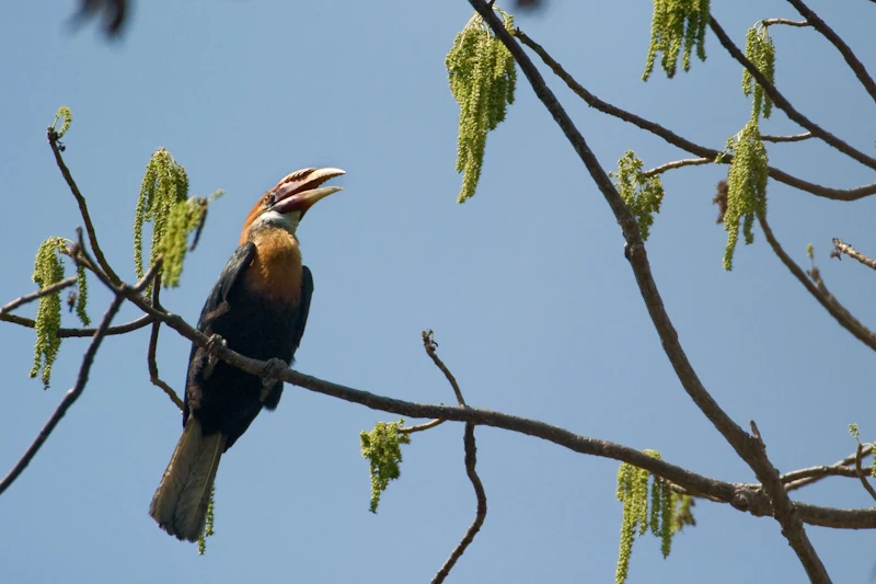
A Narcondam hornbill bird with a dark body, pale throat, and large bill perched on a thin tree branch against a clear blue sky.
A Narcondam hornbill perched on a tree branch.

Narcondam Island history and protected-area timeline

Narcondam's modern administrative history begins in 1983, when a lighthouse was established on the slopes of the volcanic peak to support maritime navigation in the northern Andaman Sea. The island's position closer to Myanmar than to mainland India made its sovereignty a point of regional significance, and until 1986 Burma formally claimed the island. That claim was relinquished only after India and Burma reached agreement on the delimitation of their maritime boundary across the Andaman Sea, the Coco Channel, and the Bay of Bengal, firmly placing the island within Indian territorial administration.

The ecological history of Narcondam took on a more formal dimension when the island was notified as a wildlife sanctuary by the government of India, a designation designed primarily to protect and monitor the Narcondam hornbill. The island has since been included on UNESCO's tentative list of World Heritage Sites, recognizing its exceptional conservation value as one of the smallest habitats supporting an endemic bird species in Asia.

The island's volcanic history has also been subject to re-evaluation. Once considered dormant in modern times, Narcondam was classified as an active volcano by the Geological Survey of India. In June 2005, reports described emissions of mud and smoke from the volcano, an event some researchers have linked to underground magma movement potentially triggered by the 2004 Indian Ocean earthquake. These episodes have reinforced Narcondam's significance as both a living geological feature and a protected natural sanctuary.

Narcondam Island landscape and geographic character

Narcondam Island is defined by its dramatic vertical profile. From its roughly 12-kilometre coastline, the terrain rises steeply to a central peak of 710 metres, forming a compact, cone-like landmass that dominates the surrounding sea. The slopes are largely forested, creating a near-continuous wall of tropical vegetation around the volcanic core, with grassy slopes visible on the southern and southeastern aspects where conditions are more exposed.

The island's shoreline is relatively short and steep, making landings limited, while the surrounding seabed drops quickly into deeper Andaman Sea waters. This abrupt descent is part of what gives Narcondam its distinctive underwater landscape of rocky ridges, pinnacles, and reef walls. The combination of narrow island width, rapid elevation gain, and surrounding deep water creates an unusually compressed transition from terrestrial forests to pelagic marine environments.

On a regional scale, Narcondam sits at the far eastern edge of the Andaman Island chain, closer to the Coco Channel and Myanmar than to Port Blair, which lies some 256 kilometres to the southwest. Its peak is only slightly lower than Saddle Peak on North Andaman Island, which at 752 metres is the highest point in the union territory. This makes Narcondam the second-tallest landform in the Andaman and Nicobar Islands, despite being one of the smallest islands in the chain.

Narcondam Island ecosystems, habitats, and plant life

Narcondam Island supports an unusually complete spectrum of tropical forest types within its small area. The vegetation ranges from tropical evergreen and semi-evergreen formations on the higher slopes to moist deciduous forest, littoral forest, and mangrove communities along the shoreline. This layered habitat structure allows the island to sustain a wide variety of plant species despite its limited size, including dipterocarp, sideroxylon, and ficus trees on upper elevations, and Terminalia and Caryota mitis nearer the shore.

Old, decaying trees interlaced with thorny creepers and tall flowering species are reported across the island, contributing to a complex forest canopy that provides both nesting sites and foraging opportunities for native wildlife. Some areas toward the summit support moist evergreen vegetation carrying epiphytes, indicating the persistence of relatively undisturbed humid forest even at higher altitudes.

The shoreline vegetation includes natural littoral species as well as introduced coconut and banana trees associated with the small human settlement on the northeast side of the island. Grassy slopes in the south and southeast contribute additional habitat diversity, creating a mosaic that supports different elements of the island's endemic fauna and seasonal visitors.

Narcondam Island wildlife and species highlights

Narcondam is renowned for its role as the sole habitat of the Narcondam hornbill, a threatened species whose global population is confined entirely to this island. With only a few hundred individuals estimated to remain, the hornbill represents one of the most range-restricted bird species in Asia, and its closest living relative is the Blyth's hornbill found elsewhere in the region. Alongside the hornbill, roughly two to three dozen bird species have been documented on Narcondam, including both residents and seasonal visitors.

Mammalian diversity on Narcondam is constrained by the island's small size and isolation, but includes native species such as the island flying fox and the Sikkim rat, along with an unidentified small bat recorded during surveys. Introduced goats and cats formerly threatened native fauna, particularly through pressure on hornbill nests and juveniles, but most of these invasive animals have since been removed. In recent years a previously unknown shrew species was described from the island, the Narcondam shrew, which along with the hornbill is one of only two endemic mammals now recognized as restricted to Narcondam.

Reptiles are well represented across the island. The spotted forest skink is the most commonly encountered lizard, while the Andaman-endemic Tytler's skink is also abundant, with Narcondam's population noted as slightly smaller than those on the main Andamans. Several gecko species restricted to the Andaman-Coco island chain have been documented on Narcondam, including the Andaman Islands day gecko, the Andaman bent-toed gecko, the Andaman giant gecko, and Anderson's day gecko. The Andaman water monitor is the island's only large terrestrial predator and is known to prey on hornbills, especially young birds. In surrounding waters, the blue-lipped sea krait is regularly observed, and historical surveys have reported the paradise flying snake on the island.

Narcondam Island conservation status and protection priorities

Narcondam Island holds considerable conservation significance because of the extreme geographic restriction of its native species. The island's formal designation as a wildlife sanctuary reflects a deliberate national effort to protect and monitor the Narcondam hornbill, whose entire global population is confined to this single small landmass. Without this protected status, the species would face the combined pressures of habitat loss, invasive species, and nest predation that have affected island endemics elsewhere in the tropics.

The sanctuary status is reinforced by the island's inclusion on UNESCO's tentative list of World Heritage Sites, recognizing both the volcanic landscape and the unique biological value of the forested ecosystem. Conservation management has included the removal of introduced goats and cats that once threatened nesting success of the hornbill, after which population trends are reported to have stabilized.

The sanctuary's relationship with proposed infrastructure illustrates the tensions involved in protecting such a restricted ecosystem. A plan by the Indian Coast Guard to install a coastal surveillance radar on the island was initially rejected by environmental authorities because of risks to the endemic hornbill population, although clearance was later granted. Subsequent modifications to the plan meant that, as of recent reporting, no radar facility had been constructed, preserving the island's largely undisturbed character and emphasizing its recognition as a sensitive, high-priority conservation area.

Narcondam Island cultural meaning and human context

Narcondam Island has minimal permanent human settlement, and its cultural footprint is shaped almost entirely by the small police outpost on the northeast corner and historical maritime interactions around its shores. The island's name itself reflects regional linguistic traditions, with one suggested etymology linking it to the Tamil phrase naraka-kundram, meaning a pit of Hell, although this derivation may partly result from historical confusion with nearby Barren Island.

The island's proximity to Myanmar and its former role in the Burma-India maritime boundary dispute highlight how small, seemingly remote islands in the Andaman Sea have carried cultural and diplomatic significance well beyond their physical size. Today, Narcondam's cultural identity is closely tied to its role as a protected natural sanctuary, with its limited population serving primarily an administrative and protective function rather than forming an indigenous community.

Top sights and standout views in Narcondam Island

Narcondam Island stands out for the unusual concentration of distinctiveness within a very small area: a forested volcanic peak, near-complete tropical forest cover, two endemic vertebrate species of global conservation concern, and richly varied marine habitats along all sides. The Narcondam hornbill in particular gives the island a recognizable identity in international biodiversity circles, while the surrounding reefs and pinnacles have placed it on the map for remote live-aboard diving in the Andaman Sea.

The island's protected status, tentative World Heritage recognition, and minimal human disturbance combine to make it a rare example of a small tropical island where ecological processes remain largely intact. Narcondam's appeal lies less in dramatic scenery alone and more in the layered relationship between its volcanic geology, its forest ecosystems, its endemic wildlife, and its strategic position in the Bay of Bengal.

Best time to visit Narcondam Island

Like much of the Andaman region, Narcondam experiences a tropical climate with relatively stable warm temperatures year-round, averaging around 30 degrees Celsius in summer and about 23 degrees Celsius in winter. Conditions are generally more comfortable during the drier months, when seas tend to be calmer and visibility for diving and reef viewing is typically at its best.

The period outside the main monsoon months is usually preferable for any activity involving reaching the island, since accessibility depends on sea conditions and limited ship or helicopter service from Diglipur. For bird-focused visits, attention to the breeding cycle of the Narcondam hornbill may be relevant, while for diving, more stable sea states improve both access and the quality of underwater experiences around the island's steep reef slopes.

Monthly climate preview

Long term temperature averages and monthly precipitation distributions for Narcondam Island

Narcondam Island Climate Normals and Annual Weather Patterns

Historical monitoring data records measured monthly temperature variations and precipitation rhythms across a representative coordinate of Narcondam Island. Detailed twelve month comparisons provide deeper context on long term thermal baselines and regional moisture distribution.
Annual mean28 °C
26 °C29 °C
Jan26°
Feb27°
Mar27°
Apr29°
May29°
Jun29°
Jul28°
Aug28°
Sep28°
Oct28°
Nov28°
Dec27°
Warmest month
May

29.1 °C

Coolest month
January

26.4 °C

Wettest month
July

13.8 mm/day

Driest month
February

0.2 mm/day

Park location guide

Geography guide, regional context, and park location map for Narcondam Island

Narcondam Island park geography, regions, and map view in India

Understand where Narcondam Island sits in India through a broader geographic reading of the surrounding landscape, nearby location context, and its mapped position within the national park landscape.

How Narcondam Island fits into India

India is a South Asian country bordered by the Indian Ocean, Arabian Sea, and Bay of Bengal. It shares land borders with Pakistan, China, Nepal, Bhutan, Bangladesh, and Myanmar. The country has a population of over 1.4 billion people and operates as a federal parliamentary republic with its capital in New Delhi.

Wider geography shaping Narcondam Island in India

India occupies the Indian subcontinent in South Asia, bordered by the Arabian Sea to the southwest, the Bay of Bengal to the southeast, and the Indian Ocean to the south. It shares land borders with Pakistan to the west, China, Nepal, and Bhutan to the north, and Bangladesh and Myanmar to the east. The territory also includes the Andaman and Nicobar Islands in the Indian Ocean.

Map view of Narcondam Island

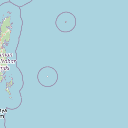
Use this park location map to pinpoint Narcondam Island in India, understand its exact geographic position, and read its mapped placement within the surrounding landscape more clearly.

Pigeon | © OpenStreetMap contributors

Location context for Narcondam Island

Andaman and Nicobar Islands

Visual exploration of steep volcanic terrain, dense evergreen forests, and isolated island ecosystems

Narcondam Island Photos: Volcanic Landscapes, Forest Scenery, and Protected Habitats

Visual records reveal the dramatic vertical relief, dense tropical forest canopy, and steep volcanic terrain that define Narcondam Island. Examining protected-area photography provides a clearer understanding of remote island habitats, volcanic geology, and marine environments in the Andaman Sea.

A Narcondam hornbill bird with a dark body, pale throat, and large bill perched on a thin tree branch against a clear blue sky.

A wide shot of a lush, green volcanic island rising steeply from the deep blue ocean under a clear sky with scattered white clouds.

Park atlas

Compare surrounding island sanctuaries, marine reserves, and regional protected landscapes

Exploring Parks Near Narcondam Island and Related Protected Areas

Browse protected areas near Narcondam Island to examine broader ecological patterns across the Andaman Sea. Continuing into adjacent regional parks provides valuable geographical context for isolated volcanic ecosystems.
Wildlife reserveAndaman and Nicobar Islands
About 134 km away#1 closest

West

Kwangtung Island Wildlife Sanctuary: Protected Forest and Shoreline Atlas

Geography and island habitat analysis in North Andaman.

Kwangtung Island Wildlife Sanctuary preserves a representative tropical island forest and coastal ecosystem in the North Andaman Islands. This wildlife reserve offers insight into the region's distinctive island-based conservation, featuring a dense mosaic of vegetation and marine-influenced margins that support a range of native Andaman fauna.

Area
0.57 km²
Established
1987
IUCN
IV
Relief
Lowland
National parkIndia
About 137 km away#2 closest

West

Saddle Peak National Park: Mapped Boundaries and National Park Geography

Explore India's protected landscapes and regional terrain.

Saddle Peak National Park stands as a distinct national park within India, offering rich opportunities for geographic exploration. Examine its mapped boundaries and understand its specific landscape characteristics. This entry serves as a vital point for comprehending the park's protected status and its contribution to the atlas of India's natural terrain.

Area
32.54 km²
Established
1979
IUCN
II
Relief
Mountain
A pale watercolor painting showing rolling green hills and a gentle stream or meadow under a soft, light sky.
Protected areaAndaman and Nicobar Islands
About 137 km away#3 closest

South

Barren Island Protected Area: Volcanic Landscape and Andaman Sea Geography

A remote stratovolcano and marine sanctuary in the Andaman Sea

Barren Island represents a significant geological landmark as the only active volcano in the Indian subcontinent. The protected area features a complex volcanic edifice with fresh lava flows, pyroclastic cones, and a central caldera that supports an evolving ecosystem. Beyond the land, the island provides a unique underwater topography of basaltic formations and coral-colonized lava beds within the Andaman and Nicobar Islands territory.

Area
8.34 km²
Relief
Mountain
Climate
Tropical
Access
Remote access
Wildlife reserveAndaman and Nicobar Islands
About 151 km away#4 closest

West

Bamboo Island Wildlife Sanctuary: Mapping Coastal Protected Landscapes in the Andaman Archipelago

Coastal habitat, coral reefs, and littoral forest geography

Bamboo Island Wildlife Sanctuary represents a crucial protected area within the Andaman and Nicobar Islands, focusing on the interface between unique littoral bamboo thickets and surrounding marine reef environments. This reserve highlights the role of small island geography in conserving coastal stability and sensitive marine habitats within the Indian Bay of Bengal territory.

Area
0.05 km²
Established
1987
IUCN
IV
Relief
Lowland
Wildlife reserveAndaman and Nicobar Islands
About 163 km away#5 closest

Southwest

Cuthbert Bay Wildlife Sanctuary: Coastal Habitat and Sea Turtle Nesting Ground

Eastern Middle Andaman protected coastal geography

Cuthbert Bay Wildlife Sanctuary covers 5.8 square kilometres of critical coastal terrain along the eastern Middle Andaman coastline. Renowned for its concentration of sea turtle nesting beaches, the reserve supports diverse coastal ecosystems ranging from open sand to inland forest patches. It serves as a compact but vital ecological anchor within the broader landscape of the Andaman and Nicobar Islands.

Area
5.8 km²
Established
1997
IUCN
IV
Scope
Terrestrial
National parkAndaman and Nicobar Islands
About 181 km away#6 closest

Southwest

North Button Island National Park: Protected Landscape and Mapped Geographic Identity

Explore the mapped boundaries and regional natural terrain.

Gain a clear understanding of North Button Island National Park as a distinct protected landscape within the Andaman and Nicobar Islands region. This entry offers detailed geographic context, focusing on the park's mapped boundaries and its role within the archipelago's natural terrain. It serves as a foundational element for understanding this Indian National Park's place in a broader atlas of conservation areas.

Area
114 km²
Established
1979
Protected areaAndaman and Nicobar Islands
About 182 km away#7 closest

West

Interview Island Protected Area: Geography, Forested Plateau, and Island Map

A remote wilderness sanctuary in the Andaman archipelago

Interview Island encompasses a secluded, 23 kilometer long landscape characterized by dense tropical forests and a rising southern plateau. This protected area stands out for its feral elephant population and near-undisturbed coastal environment, providing a compelling focus for geographic exploration and study of the Andaman island chain.

Area
101 km²
Established
1997
Relief
Upland
Water
Major water bodies
National parkAndaman and Nicobar
About 187 km away#8 closest

Southwest

Middle Button Island National Park: National Park within Andaman and Nicobar's Geography

Explore protected landscape context and mapped park boundaries.

Middle Button Island National Park represents a significant protected natural landscape, offering users a focused entry point for geographic discovery. As a designated national park, it contributes distinct mapped boundaries and terrain characteristics to the Andaman and Nicobar region's atlas data. Understanding its specific identity helps contextualize the broader protected-area network and regional geography. This page details the park's role as a conserved territory, vital for those seeking structured landscape and geography information.

Area
64 km²
Established
1979
Relief
Lowland
Climate
Tropical

Common questions about visiting, size, designation, and location context for Narcondam Island

Narcondam Island FAQs for park facts, access, geography, and protected area context

Find quick answers about Narcondam Island, including protected-area facts, park geography, trail and visitor context, and how the park fits into its surrounding country and regional landscape.
MoriAtlas Explorer

Continue Your Protected Areas Search Across the Global Atlas

Deepen your exploration by continuing the structured search for national parks and protected areas worldwide. Utilize the comprehensive filtering capabilities to compare different conservation landscapes and refine your understanding of global park geography. Discover more about the distribution and characteristics of protected natural areas.

Global natural geography