
Capes
Park geography
Detailed analysis of terrain elevation, volcanic landscape features, and marine territory
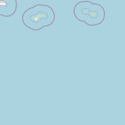
Comprehensive Geographic Profile and Mapped Boundaries of the National Park of American Samoa
This geographic profile examines the structural composition of the National Park of American Samoa. Covering both land and marine sectors, the data includes elevation ranges reaching 970 meters, volcanic crater formations, and complex coastal features across the protected landscape.
Related tags
tropical rainforestcoral reefsvolcanic islandsPacific islandsmarine biodiversity
America's only national park south of the equator, protecting tropical rainforests, coral reefs, and Samoan culture across three remote Pacific islands
National Park of American Samoa
The National Park of American Samoa is a unique protected area spanning three islands in the remote American Samoa territory, making it the only unit of the United States National Park System located south of the equator. Established in 1988, the park encompasses 8,257 acres of tropical rainforest, volcanic landscapes, and marine environments across Tutuila, Ofu, and Ta'ū islands. The park preserves one of the most biologically diverse marine environments in the world, with over 250 coral species and more than 950 fish species, alongside endangered fruit bats and approximately 30% endemic plant species. Unlike most national parks, the land remains under traditional Samoan communal ownership, with the National Park Service operating under a 50-year lease agreement with local village councils. The park protects critical habitats while maintaining the delicate balance between conservation and the cultural practices of the Samoan people who have inhabited these islands for centuries.
- Location
- United States of America
- Park type
- National park
- Established
- 1988
- Area
- 33.4 km²
- Highest point
- 970 m
Location overview
Territory records and coastal island status in American Samoa
Geographic Profile of the National Park of American Samoa
Territory records locate the park in the United States of America within the region of American Samoa. Verified attributes confirm the territory is a coastal, island, and marine park under a single country jurisdiction.
- Countries
- American Samoa, United States of America
- Regions
- American Samoa
- Primary location
- United States of America
- Geographic setting
- Coastal · Island · Marine
Boundary and coordinates
American Samoa’s 33.414 km² total separates land and marine area
National Park of American Samoa mapped boundary and area records
National Park of American Samoa has mapped geometry that frames its extent without defining a legal survey. Its facts retain the 33.414 km² overall, 23.3 km² land, and 10.1 km² marine areas as separate records.
- Boundary area
- 44.9 km²
- Boundary perimeter
- 70.8 km
- Northernmost point
- 14.168° S
- Southernmost point
- 14.2837° S
- Easternmost point
- 169.4175° W
- Westernmost point
- 170.7279° W
- Geographic centre
- 14.245° S, 169.9263° W
- North–south span
- 12.8 km
- East–west span
- 141.4 km
Elevation and terrain
Mountain relief metrics and mapped natural landforms
National Park of American Samoa Terrain and Elevation Range
Recorded elevation ranges span from sea level to nine hundred seventy meters across mountain terrain. Linked feature cards supply official names, types, and spatial relationships for interior points, streams, and bays.
- Minimum elevation
- 0 m
- Maximum elevation
- 970 m
- Highest point
- 970 m
Selected named natural features
Capes
Nuutoga Point
Bays
Maefu Cove
Peaks
Fatifati Mountain
317 m
Streams
Vaisa Stream
Islands
Taʻū
Environmental setting
Tropical forest zones, island topography, and marine coastal relief profiles
National Park of American Samoa Environmental Classifications and Physical Settings
Stored landscape features and habitat types frame the physical setting across mountain relief and coastal waters. Recorded categories link directly to relevant atlas destinations for comprehensive regional navigation.
- Relief
- Mountain
- Climate
- Tropical
- Water
- Major water bodies
- Forest cover
- Mostly forested
- Seasonality
- Year-round
Landscape features
Mountains · Cliffs · Forest · Beach · Coast · Islands · Volcano · Cave · Reefs
Habitat types
Tropical forest · Montane forest · Coastal habitat · Marine habitat
Park atlas
Browse mapped protected areas, compare diverse island landscapes, and trace conservation efforts across the Pacific region.
Continue Your Park Discovery: Explore Protected Areas Near National Park of American Samoa
After exploring National Park of American Samoa, discover other national parks and protected areas across the vast Pacific Ocean region. Compare varied island ecosystems, volcanic landscapes, and significant marine conservation efforts through a broader regional park atlas view.
Marine protected areaAmerican Samoa
Park boundaries overlap#1 closest
Southwest
National Marine Sanctuary of American Samoa: Mapped Marine Protected Area Geography
Discover protected marine landscapes across American Samoa's region.
Investigate the National Marine Sanctuary of American Samoa, a protected marine area with distinct geographic relevance. This detailed view focuses on its mapped boundaries and its role as a protected landscape within the broader atlas of American Samoa. Understand the unique environmental context and protected-area significance that shapes this marine sanctuary.
- Area
- 35,170 km²
- Established
- 1986
- Climate
- Tropical
- Access
- Easy access
Marine protected areaAmerican Samoa
44 km away#2 closest
East

Rose Atoll Marine National Monument: Protected Marine Area in American Samoa
Explore mapped boundaries and regional geographic context.
Rose Atoll Marine National Monument is designated as a marine protected area within the geographic scope of American Samoa. This page offers detailed insights into its protected status, mapped terrain, and the surrounding natural landscapes. It serves as a resource for understanding the park's specific boundaries and its role as a conservation area, providing a foundation for geographic discovery.
- Relief
- Lowland
- Scope
- Marine
- Water
- Water-dominated
National parkSamoa
111 km away#3 closest
West
O Le Pupu-Puʿe National Park: Explore Samoa's Protected National Park Geography and Boundaries
Mapped terrain and protected landscape context for this Samoan national park.
Understand O Le Pupu-Puʿe National Park as a significant protected area within Samoa's archipelago. This detail entry provides essential geographic context, mapping its boundaries and situating it within the nation's protected lands. Explore the park's role as a national park and its contribution to the mapped natural landscape of Samoa.
- Area
- 50.2 km²
- Established
- 1978
- IUCN
- II
- Relief
- Mixed relief
National parkUpolu
About 126 km away#4 closest
West
Lake Lanoto'o National Park: Discover Its Protected Landscape and Geographic Setting on Upolu
Explore park boundaries and regional natural terrain.
Lake Lanoto'o National Park represents a crucial protected area on the island of Upolu, Samoa. This page provides detailed geographic information, focusing on the park's mapped boundaries and its contribution to the natural landscape of the region. Understand its role as a national park and its position within the broader atlas of protected lands, offering insight into the island's unique geography.
- Area
- 4.7 km²
- Established
- 2003
- IUCN
- II
- Relief
- Highland
Wildlife reserveAmerican Samoa
About 140 km away#5 closest
East
Rose Atoll National Wildlife Refuge: Southernmost U.S. Wildlife Reserve & Mapped Coral Ecosystem
Discover unique protected landscape geography in American Samoa.
Rose Atoll National Wildlife Refuge is a remote U.S. wildlife reserve situated in American Samoa, distinguished by its unique atoll structure and the southernmost geographical coordinates within the United States. This protected area is renowned for its exceptional marine biodiversity, including extensive coral reef ecosystems, a significant seabird nesting colony, and vital sea turtle habitats. Exploring this refuge offers a window into distinct regional geography, mapped marine protected areas, and the ecological significance of isolated Pacific atolls.
- Area
- 158.09 km²
- Established
- 1973
- IUCN
- Ia
- Relief
- Lowland
National parkTonga
About 904 km away#6 closest
Southwest

'Eua National Park: Tonga Protected Landscape and Geographic Context
Explore mapped boundaries and unique natural terrain within Tonga.
Access detailed geographic information and mapped boundaries for 'Eua National Park, Tonga's designated national park. This resource provides an atlas-style overview of the park's protected landscape identity, focusing on its natural terrain and its specific place within the broader geography of the Kingdom of Tonga. Understand the park's conservation significance through its landscape context and mapped distribution.
Nature reserveNew Zealand
About 1,818 km away#7 closest
Southwest

Kermadec Islands Nature Reserve: Mapping the Volcanic Terrain and Subtropical Ecosystems
A remote New Zealand volcanic arc and marine protected area.
The Kermadec Islands comprise an isolated chain of volcanic landforms stretching along a submarine ridge in the South Pacific. This nature reserve protects unique subtropical moist forests, diverse seabird colonies, and complex hydrothermal vent communities, serving as a critical area for ongoing ecological restoration and marine science.
- Area
- 33.6 km²
- Established
- 1937
- Relief
- Mountain
- Climate
- Subtropical
Marine protected areaNorfolk Island
2,476 km away#8 closest
Southwest

Norfolk Marine Park: A Comprehensive Look at Australia's Offshore Protected Ocean Reserve
Marine geography, deep sea features, and ocean convergence zones
Norfolk Marine Park represents a vast expanse of offshore territory defined by varied seafloor bathymetry including ridges, plateaus, and troughs. As a key component of the Temperate East Marine Parks Network, the reserve protects the Tasman Front, where dynamic water masses interact to drive biological productivity across the South Pacific. Its geographic isolation and structural diversity make it a pivotal research site for understanding regional marine ecosystems and deep-water fauna connectivity.
- Area
- 188,444 km²
- Established
- 2018
- IUCN
- IV
- Climate
- Subtropical
MoriAtlas Explorer
Continue Exploring National Park of American Samoa's Geographic Identity and Map Context
Delve deeper into the specific geographic attributes and mapped boundaries of National Park of American Samoa. Understanding its unique island terrain and regional atlas placement supports a more informed exploration of protected natural areas within the United States. Gain structured insight into the park's protected landscape and its contribution to the nation's conservation geography.
Browse next
Global natural geography
Explore related park routes
Explore MoriAtlas Global ParksBrowse All MoriAtlas ParksGlobal Park Map DiscoveryMoriAtlas: Browse All CountriesBrowse All MoriAtlas ContinentsNational Park Environment AtlasGrand Canyon National Park AtlasYellowstone National Park AtlasYosemite National Park Atlas and GeographySerengeti National Park AtlasGalápagos National Park Protected LandscapeBanff National Park Geography and AtlasKruger National Park Atlas EntryUluṟu-Kata Tjuṯa National Park AtlasExplore Uluru-Kata Tjuta National Park GeographyPlitvice Lakes National Park AtlasFiordland National Park Protected LandscapeGreat Smoky Mountains National Park AtlasAfghanistan National Parks and Protected AreasAlbania National Parks and Protected AreasAlgeria National Parks and Protected AreasAmerican Samoa National Parks and Protected AreasAndorra National Parks and Protected AreasAngola National Parks and Protected AreasAntarctica National Parks and Protected AreasAntigua and Barbuda Park List