Mori Atlas logo
Protected landscapeNaturpark Nassau

Mapping the convergence of the Westerwald, Taunus, and Middle Rhine river corridors.

Naturpark Nassau: A Protected Landscape Map of the Rhenish Slate Mountains and Lahn Valley

Naturpark Nassau represents a significant protected landscape in Rheinland-Pfalz, defined by its complex terrain within the Rhenish Slate Mountains. This region features deeply incised river valleys, alternating forested ridges, and highland plateaus that bridge the Westerwald and Taunus. Through systematic mapping of its protected boundaries, visitors can examine the diverse physical geography of the Lahn and Rhine corridors, which host an extensive network of long-distance hiking routes across this classic German Mittelgebirge terrain.

nature parkGerman NaturparkRhenish Slate MountainsWesterwaldTaunusLahn Valley

Naturpark Nassau

Protected landscape

Park overview

Structured park overview, official facts, and landscape profile for Naturpark Nassau

Naturpark Nassau park facts, protected area profile, and essential visitor context

Review the core facts for Naturpark Nassau, including designation, size, terrain, visitor scale, habitats, and operating context in one park-focused overview.

About Naturpark Nassau

Naturpark Nassau sits in the heart of the Rhenish Slate Mountains, a low mountain range characterized by folded Devonian slates, greywacke, and quartzites that erode into rounded ridges and deeply incised valleys. Within this wider geological context, the park covers a particularly varied corner where the western Westerwald, the northwestern Taunus, and the eastern edge of the Middle Rhine Valley all meet. The Lahn River runs through the park from east to west, providing a structuring valley axis, while smaller streams descend from ridge crests toward both the Lahn and the Rhine.

At its core, the park exists at the intersection of cultural and natural landscape: deeply forested slopes, open agricultural valleys, traditional villages, and historic town settings coexist within its boundaries. Towns such as Montabaur, Diez, and Lahnstein carry the regency or ducal heritage of the wider Nassau region and act as gateway communities for the park. Vineyards and orchards, especially along the right-bank Rhine slopes between Lahnstein and Kamp-Bornhofen, add a strong viticultural element to the cultural landscape.

From a recreational and ecological standpoint, Naturpark Nassau is a classic example of a German nature park as defined under the federal natural landscape framework: an area where conservation, sustainable land use, and public enjoyment of nature are pursued together. Its protected purpose is explicitly tied to maintaining scenic beauty and the recreation value of the Lahn Valley, its tributaries, and the right-bank Rhine slopes, rather than to strict ecosystem preservation alone. This dual mandate is reflected in the dense network of hiking routes and in the management role played by the surrounding districts.

Quick facts and research context for Naturpark Nassau

Naturpark Nassau covers an area of about 561.71 square kilometers (56,171 hectares), all within Rhineland-Palatinate in western Germany. It is administered jointly by the Rhein-Lahn-Kreis and the Westerwaldkreis through the Zweckverband Naturpark Nassau, an inter-municipal body rather than a single national authority.

The park was designated in November 1963 and extended in 1979. Its terrain spans the southwestern Westerwald, the northwestern Taunus, the Lahn Valley, and part of the Middle Rhine corridor, anchored by towns such as Montabaur, Diez, and Lahnstein. Highest elevations include the Alarmstange at about 545.2 meters above sea level in the Montabaurer Höhe portion of the Westerwald, and the Grauer Kopf at about 543.4 meters in the western Hintertaunus.

Protection and recognition

Review documented protection status and regional conservation parameters for Naturpark Nassau.

Naturpark Nassau Protection Status and Terrestrial Conservation Scope

Naturpark Nassau encompasses a documented terrestrial protection scope without imported international recognition sources or transboundary classifications. Structured conservation metrics outline the regulatory framework and formal designation parameters established for the protected area.

Protection details

Protection scope
Terrestrial
Transboundary protection
No
Park context

Deeper park guide and search-rich context for Naturpark Nassau

Naturpark Nassau history, landscape, wildlife, and travel context

Explore Naturpark Nassau through its history, landscape character, ecosystems, wildlife, conservation priorities, cultural context, and seasonal travel timing in a structured park guide built for atlas discovery and search intent.

Why Naturpark Nassau stands out

Naturpark Nassau is best known for its dramatic convergence of distinct German low-mountain landscapes within a single protected area, where the wooded ridges of the Westerwald meet the northern edge of the Taunus, the Lahn Valley, and the UNESCO-listed Middle Rhine slopes. The park's identity is closely tied to its role as a transition zone between these classic Mittelgebirge regions, rather than to a single dominant ecosystem or signature species. Long-distance hiking is a central feature of the park's reputation. The area hosts portions of well-known German trails such as the Lahnhöhenweg, the Rheinhöhenweg, the Limeswanderweg, and the European long-distance path E1, supported by approximately 290 kilometers of supraregional and 750 kilometers of regional hiking routes. Together, these linear routes reinforce the park's image as a connective landscape between two great river corridors, the Lahn and the Rhine.
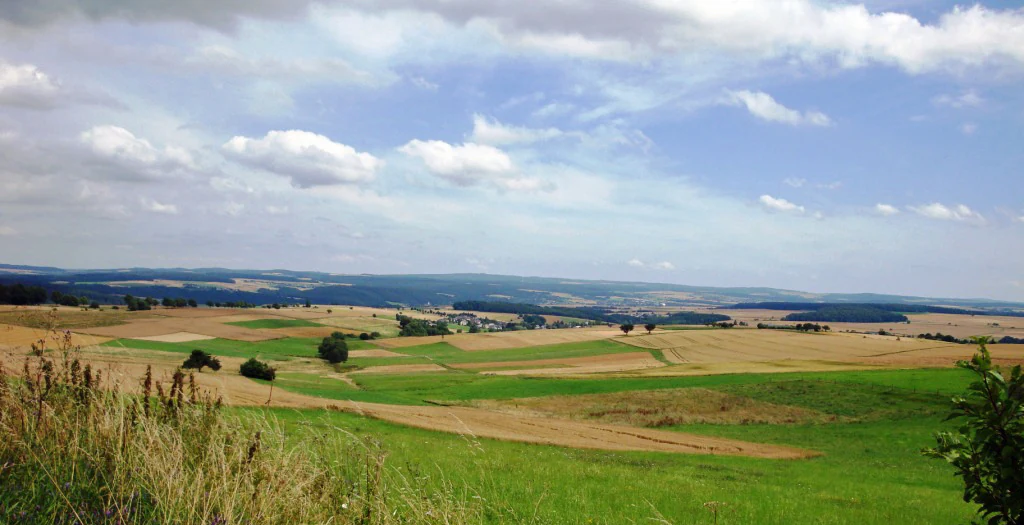
A wide, elevated view of rolling agricultural fields and meadows in hues of yellow and green, with patches of distant forest and a cloudy blue sky.
A view over the rolling hills of the western Hintertaunus region within Naturpark Nassau.

Naturpark Nassau history and protected-area timeline

Naturpark Nassau was officially designated in November 1963, placing it among the early wave of nature parks established in West Germany during the 1960s, a period when federal and state authorities were expanding formal landscape conservation alongside growing outdoor recreation demand. In 1979, the park's boundaries were significantly extended, increasing both its geographic reach and its ecological coherence across district lines.

Since its foundation, the park has been administered not by a single national or state agency but through the Zweckverband Naturpark Nassau, a public-law association combining the Rhein-Lahn-Kreis and the Westerwaldkreis. This inter-municipal governance reflects the German tradition of nature parks as cooperative projects between local communities and conservation interests, and it has allowed the park to coordinate activities across two districts with somewhat different administrative histories.

Over the decades, the park has produced a small body of regional natural history documentation on its habitats, plants, mammals, and species-rich meadows. These publications, including works by Manfred Braun and co-authors on biotopes, flowering plants, and mammals of the park, indicate a long-running tradition of locally focused natural history research rather than large-scale scientific programs.

Naturpark Nassau landscape and geographic character

The landscape of Naturpark Nassau is shaped by the classic features of the Rhenish Slate Mountains: deeply incised river valleys, alternating ridges and basins, broad upland plateaus, and forested slopes narrowing toward the rivers. The Lahn Valley runs roughly east-west through the park, providing the lowest and most open terrain and acting as the main visual and structural axis. From the Lahn, smaller valleys branch north into the Taunus and south into the Westerwald, creating a finely textured valley system.

On the southern edge of the park, the terrain drops toward the Middle Rhine, where the right-bank slopes between Lahnstein and Kamp-Bornhofen form one of the park's most distinctive landscape zones. These slopes combine steep forested sections, rocky outcrops typical of the slate highlands, and the cultural elements of Rhine-side vineyards and traditional settlements. To the north, the Montabaurer Höhe rises as a distinct highland block, while the western Hintertaunus extends the park's terrain into more gently rolling, heavily wooded uplands.

Elevations remain moderate throughout the park. The Alarmstange, at about 545.2 meters above sea level in the Montabaurer Höhe section, is the highest point in the Westerwald portion of the park, while the Grauer Kopf reaches about 543.4 meters in the western Hintertaunus. The lowest areas lie along the Lahn and Rhine corridors. The result is a landscape of considerable local relief, but one that remains easily traversable on foot and offers frequent panoramic views from ridge crests into the river valleys below.

Naturpark Nassau ecosystems, habitats, and plant life

Ecologically, Naturpark Nassau belongs to the forest-dominated landscape type typical of the western Rhenish Slate Mountains and the Taunus foothills. Mixed forests, mostly deciduous with significant beech and oak presence, cover much of the upland and slope terrain, while the river valleys host a different mosaic of meadows, pastures, hedgerows, orchards, and small settlement clearings. This combination produces the characteristic patchwork pattern of wooded hills and open valley ground that defines much of the park.

Habitat diversity is closely linked to elevation, slope orientation, and river influence. Steeper slopes along the Middle Rhine harbor warm, dry woodland communities and open rocky habitats, while the higher Westerwald and Taunus ridges support cooler, more continually forested environments. The Lahn and its tributaries create corridors of riparian vegetation and alluvial soils that contrast with the surrounding uplands and support distinct plant communities. Together with small traditional agricultural features such as species-rich meadows and orchard meadows, these habitats give the park a rich ecological gradient despite its modest absolute elevation.

Because the park's official conservation purpose explicitly combines preservation of scenic character with sustainable land use, the nature park functions less as a strictly protected wilderness and more as a managed cultural landscape. Land use, especially forestry, agriculture, and viticulture along the Rhine slopes, continues within the park under regional planning frameworks, while recreation and tourism coexist with habitat maintenance. This integrated approach is typical of German Naturpark designations and shapes the ecological character of Naturpark Nassau today.

Naturpark Nassau wildlife and species highlights

The wildlife of Naturpark Nassau reflects the broader fauna of the western Rhenish Slate Mountains and the Taunus foothills, with forested uplands and river valleys supporting different but overlapping species communities. Typical woodland mammals of the mixed beech and oak forests, including red deer, roe deer, and wild boar, are present across much of the park, while the more open valleys and meadow zones provide habitat for smaller mammals and a range of bird species associated with mixed agricultural and forest landscapes.

The park's specific mammalian fauna has been documented in a dedicated regional study, 'Säugetiere im Naturpark Nassau,' published in 2013 by Manfred Braun, Ursula Braun, and Philipp Schiefenhövel. This work indicates that local researchers have treated the park as a coherent unit for natural history surveys, rather than splitting it along district boundaries. Birdlife benefits from the variety of habitats, with forest species on the ridges and riparian and meadow-dependent species along the Lahn and its tributaries.

Along the steep, warm slopes of the right-bank Middle Rhine, reptiles and invertebrates associated with dry, sunny, rocky habitats add to the faunal diversity, while the cooler Westerwald and Taunus uplands favor species more typical of moist, mature forests. Although the park's wildlife profile is that of a relatively common German Mittelgebirge region rather than a site of exceptional rarity, the combination of valley and upland habitats within a single protected area supports a varied and ecologically meaningful fauna.

Naturpark Nassau conservation status and protection priorities

Conservation in Naturpark Nassau is anchored in its designation as a German Naturpark, a category intended to combine landscape preservation with sustainable regional development and public enjoyment of nature. The official conservation purpose is to maintain the scenic character and beauty of the Lahn Valley, its side valleys, the right-bank Rhine slopes between Lahnstein and Kamp-Bornhofen, and the surrounding ridges including the Montabaurer Höhe. This explicitly integrates aesthetic, recreational, and ecological goals rather than focusing purely on strict protection.

The park's governance structure reinforces this conservation model. As a Zweckverband combining the Rhein-Lahn-Kreis and the Westerwaldkreis, the park operates through local government cooperation, allowing conservation objectives to be coordinated with municipal land use, forestry, agriculture, and tourism. Long-running habitat and species documentation, such as the published surveys on biotopes, flowering plants, and Säugetiere im Naturpark Nassau, demonstrate an ongoing commitment to understanding and monitoring the park's natural resources.

At a broader level, Naturpark Nassau contributes to the network of protected cultural landscapes of the Rhenish Slate Mountains, linking low-intensity agricultural valleys, extensive forests, and the iconic Middle Rhine corridor. By safeguarding the visual and ecological character of this transition zone between Westerwald, Taunus, Lahn, and Rhine, the park supports regional biodiversity and maintains landscape qualities that underpin both local identity and the UNESCO-recognized Middle Rhine cultural landscape adjacent to it.

Naturpark Nassau cultural meaning and human context

Naturpark Nassau lies within the historic Nassau region, whose name is shared with the House of Nassau, one of Europe's historically significant dynasties. Towns such as Nassau, Diez, Montabaur, and Lahnstein are deeply tied to this heritage, with castles, residenz palaces, and old townscapes reflecting the political history of the Lahn and Middle Rhine area. The park's identity is therefore inseparable from the cultural landscape of small historic towns and villages set within valleys and along ridges.

Traditional land use has shaped the park over centuries. Agriculture, viticulture on the Rhine slopes, forestry, and small-scale craft economies have left a visible imprint on the terrain, in the form of field patterns, orchards, vineyards, woodland mosaics, and isolated farmsteads. This cultural landscape is part of what the park's protected purpose aims to preserve, recognizing that the scenic value of the Lahn and Rhine valleys depends on the continued coexistence of human activity and natural setting.

The park's hiking culture ties directly into this regional identity. Long-distance trails such as the Lahnhöhenweg, the Rheinhöhenweg, the Limeswanderweg, and the European long-distance path E1 pass through areas where Roman frontier heritage, medieval dynastic history, and post-war tourism traditions converge. Together, these layered elements of landscape, settlement, viticulture, and trails give Naturpark Nassau a cultural depth that complements its ecological role.

Top sights and standout views in Naturpark Nassau

Naturpark Nassau stands out for the unusual density of recognizable German regional landscapes within a single protected area, combining the Westerwald, the Taunus, the Lahn Valley, and the Middle Rhine. Its valley systems, ridge lines, and right-bank Rhine slopes provide a strongly varied visual and ecological character, even though elevations remain moderate.

The park is also notable for its long-distance hiking coverage, with major trails including the Lahnhöhenweg, the Rheinhöhenweg, the Limeswanderweg, and the European E1 path, supported by roughly 290 kilometers of supraregional and 750 kilometers of regional routes. Combined with about 150 hiker parking areas distributed across the territory and a well-established inter-municipal management structure, this makes the park a practical and accessible landscape for walking-based exploration of the Rhenish Slate Mountains.

Best time to visit Naturpark Nassau

Spring and early summer are particularly rewarding periods in Naturpark Nassau, when deciduous forests on the Westerwald and Taunus ridges are leafing out, valley meadows are in active growth, and orchard meadows in the traditional villages are in bloom. Late spring into early summer also tends to bring the most complete expressive character to the cultural landscape, as fresh green forests and flowering meadows frame the Lahn Valley and the Rhine slopes.

Autumn brings another strong season, with deciduous foliage turning color across the upland forests and grape harvest activity along the right-bank Rhine slopes. Summer remains appealing for long-distance hiking because the network of marked trails is fully open, though forest interiors can feel humid. Winter conditions depend strongly on elevation in the ridge sections; snow is possible but rarely persistent at the altitudes of the park. The best overall window for visitors interested in both landscape character and hiking is late spring through early autumn, with the precise choice depending on whether valley meadows, vineyard activity, or colorful forest foliage is the priority.

Monthly climate preview

Long-term temperature and precipitation patterns across representative park coordinates

Naturpark Nassau Climate Normals and Annual Weather by Month

Naturpark Nassau records long-term monthly temperature and precipitation data reflecting multi-year climatological averages at a representative coordinate. Examining the complete monthly climate normals profile provides deeper analytical insight into annual temperature ranges and precipitation rhythms.
Annual mean9 °C
0 °C19 °C
Jan
Feb
Mar
Apr
May13°
Jun16°
Jul19°
Aug18°
Sep14°
Oct
Nov
Dec
Warmest month
July

18.7 °C

Coolest month
January

0 °C

Wettest month
December

2.5 mm/day

Driest month
April

1.6 mm/day

Park location guide

Geography guide, regional context, and park location map for Naturpark Nassau

Naturpark Nassau park geography, regions, and map view in Germany

Understand where Naturpark Nassau sits in Germany through a broader geographic reading of the surrounding landscape, nearby location context, and its mapped position within the national park landscape.

How Naturpark Nassau fits into Germany

Germany is a federal republic in Western and Central Europe with a population of over 83 million across sixteen constituent states. It is Europe's largest economy by nominal GDP and a major global exporter and importer. The capital is Berlin, and the country borders Denmark, Poland, Czech Republic, Austria, Switzerland, France, Luxembourg, Belgium, and the Netherlands.

Wider geography shaping Naturpark Nassau in Germany

Germany is located in Western and Central Europe, spanning 357,022 km². It borders Denmark to the north, Poland and the Czech Republic to the east, Austria and Switzerland to the south, and France, Luxembourg, Belgium, and the Netherlands to the west. The country has coastlines on the Baltic Sea and North Sea to the north, with the Alps located in the southern region.

Map view of Naturpark Nassau

Use this park location map to pinpoint Naturpark Nassau in Germany, understand its exact geographic position, and read its mapped placement within the surrounding landscape more clearly.

Pigeon | © OpenStreetMap contributors

Location context for Naturpark Nassau

Rheinland-Pfalz

Visualizing forested ridges, river valleys, and low mountain terrain across the protected German landscape

Naturpark Nassau Photos and Landscape Scenery Exploration

Visual documentation captures the varied terrain of Naturpark Nassau, revealing deeply incised river valleys and forested low mountain ridges. Photographic records provide clear reference material for studying regional habitats and the distinct physical geography of the protected German reserve.

A wide, elevated view of rolling agricultural fields and meadows in hues of yellow and green, with patches of distant forest and a cloudy blue sky.

Park atlas

Compare adjacent low mountain terrain and connected regional river valleys.

Exploring Other Parks Near Naturpark Nassau and Surrounding Protected Landscapes

Browsing other parks near Naturpark Nassau reveals how neighboring low mountain terrain and river corridors shape the wider Rhenish Slate Mountains. Comparing these protected landscapes highlights regional geography shifts across the Westerwald, Taunus, and Rhine valleys.
A minimalist watercolor painting showing a winding river, distant hills, and a small grove of trees on the bank.
Nature reserveRheinland-Pfalz
About 13 km away#1 closest

West

Ruppertsklamm Nature Reserve: Geography and Protected Landscape Mapping in Rheinland-Pfalz

A steep, forested gorge within the Niederwesterwald

Ruppertsklamm stands as a distinctive nature reserve where extreme elevation changes and narrow valley walls create a dense, intimate habitat. The site integrates into the broader Natura 2000 network, offering a window into the complex geological and natural history of the Lahn valley slopes through its mossy rock formations and protected forest ecosystems.

Area
0.148 km²
Established
1936
Relief
Upland
Climate
Temperate
A soft, light watercolor painting of rolling green hills, scattered trees, and a winding path under a pale, warm sky.
Nature reserveWesterwaldkreis
About 18 km away#2 closest

North

Naturschutzgebiet Malberg: Geography and Protected Phonolite Landscapes in Westerwaldkreis

Geological exploration of a unique volcanic nature reserve

Naturschutzgebiet Malberg provides a focused look at a rare volcanic cupola in Germany. Centered on a 22-million-year-old phonolite summit, the reserve protects a complex environment of blockfields, craggy crevices, and natural rock caves that stand out as a sharp geographic anomaly amidst the gentle lowlands of the Montabaur Basin.

Area
0.96 km²
Established
1971
IUCN
IV
Relief
Mountain
A pale, minimalist watercolor painting of a rolling green landscape with distant hills and a small group of trees on the right.
Nature reserveRhineland-Palatinate
About 20 km away#3 closest

Southwest

Hintere Dick-Eisenbolz Nature Reserve: Geographic Context and Protected Landscape Data

Orchard meadows and invertebrate conservation in western Germany.

Situated in the Rhineland-Palatinate region of western Germany, Hintere Dick-Eisenbolz protects a 54-hectare expanse of traditional orchard meadows. This cultural landscape mosaic, characterized by fruit trees and grassland, supports high levels of insect diversity near the Rhine valley. The reserve remains an essential site for understanding the intersection of human-influenced agricultural land and critical biodiversity protection.

Area
0.546 km²
Established
1998
Watercolor painting of a gentle green valley with scattered trees and a winding path, featuring soft pastel tones.
Nature reserveHessen
About 27 km away#4 closest

Southeast

Pohlbachtal bei Adolfseck Nature Reserve: Geography and Protected Area Profile

Western Hintertaunus mosaic landscape in Hessen

Pohlbachtal bei Adolfseck protects a near-natural brook valley and surrounding slopes within the Rhein-Taunus Nature Park. This reserve sustains diverse habitats, from wet meadow floodplains to deciduous forest fringes, while preserving historical layers like the Roman Limes along its valley edges in Hessen.

Area
0.226 km²
Established
1990
IUCN
IV
A horizontal watercolor painting showing a calm lake or pond with grassy banks, small trees, and soft hills in the background.
Protected areaGermany
About 27 km away#5 closest

North

Brinkenweiher Protected Area and Westerwald Lake District Geography

Historic wetland habitat in Rhineland-Palatinate

Brinkenweiher serves as a significant example of a seventeenth-century Waldweiher, shaped by human engineering to dam the Holzbach headwaters. Today, the site functions as a protected nature reserve, offering a varied landscape of shadowed forest fringes, marshy wetlands, and open meadows that support a coherent wetland ecosystem within the broader Westerwälder Seenplatte.

Area
0.21 km²
Established
1660
Relief
Lowland
Scope
Terrestrial
Nature reserveWesterwaldkreis
About 27 km away#6 closest

North

Wölferlinger Weiher Nature Reserve: Geography and Protected Wetland Boundaries

Historic Westerwaldkreis pond and protected aquatic landscape

Wölferlinger Weiher represents a critical protected wetland within the Westerwaldkreis region of Germany. This detailed record highlights the pond's geographic role within the Westerwälder Seenplatte, covering its marshy fringes, shallow water zones, and surrounding moist meadows that define its protected area status.

Area
0.9 km²
Established
1979
Relief
Lowland
Climate
Temperate
Nature reserveRhineland-Palatinate
About 28 km away#7 closest

West

Ausoniusstein Nature Reserve: Protected Landscape and Geographic Identity in Germany

A geological and ecological refuge in the Rhineland-Palatinate countryside.

Ausoniusstein is a protected nature reserve in western Germany recognized for its unique geological and morphological character. Spanning 31 hectares, the site features rocky slopes and varied volcanic substrates that support uncommon plant life and the rare Apollo butterfly. The terrain represents the transitional landscape between the Moselle river corridor and the Eifel foothills.

Area
0.31 km²
Established
1984
Relief
Upland
Water
Minor water
Nature reserveRhineland-Palatinate
About 28 km away#8 closest

West

Nettetal Nature Reserve: Geography and Protected Boundaries in Rhineland-Palatinate

Steep-sided valley landscapes and biodiversity corridors.

Nettetal Nature Reserve offers a deep look into the geomorphology of a classic Kerbtal in Rhineland-Palatinate. This protected area along the Nette tributary showcases a rare density of contrasting terrains, from sun-exposed rock formations to damp valley floors, providing a clear window into regional conservation mapping.

Area
7.05 km²
Established
1986
Scope
Terrestrial
Water
Major water bodies

Common questions about visiting, size, designation, and location context for Naturpark Nassau

Naturpark Nassau FAQs for park facts, access, geography, and protected area context

Find quick answers about Naturpark Nassau, including protected-area facts, park geography, trail and visitor context, and how the park fits into its surrounding country and regional landscape.
MoriAtlas Explorer

Continue Your Protected Areas Search Across the Global Atlas

Deepen your exploration by continuing the structured search for national parks and protected areas worldwide. Utilize the comprehensive filtering capabilities to compare different conservation landscapes and refine your understanding of global park geography. Discover more about the distribution and characteristics of protected natural areas.

Global natural geography