Why Naturpark Niederlausitzer Landrücken stands out
The park is best known for its dramatic transformation of former lignite opencast mines into a large, evolving mosaic of lakes, swamps, dunes, and pioneer habitats. The rising Schlabendorfer See, supplied partly by Spree water and rising groundwater, is becoming one of Germany's most important gathering and roosting sites for common cranes (Kranich). Equally distinctive is the surrounding moraine landscape: the steep Lausitzer Grenzwall, the source-rich slopes of the Baruther Urstromtal, the dark forests of the Rochauer Heide, and the cultural-historical villages that frame the mining core. The Tengmalm's owl (Raufußkauz), still present in the Rochauer Heide, has long served as the symbolic emblem of the park. Together, post-mining wilderness and untouched cultural countryside make Niederlausitzer Landrücken a textbook example of how an industrialized region can become a laboratory of natural succession in central Europe.
Naturpark Niederlausitzer Landrücken history and protected-area timeline
The geological foundation of the park is ancient. The Niederlausitzer Landrücken was formed as a typical end-moraine (Endmoränenlandschaft) at the close of the Saalian glaciation, long before any human settlement appeared. The Baruther Urstromtal cut into this moraine ridge, leaving behind the steep Lausitzer Grenzwall and a dissected terrain rich in springs that would, much later, host farms, villages, and mills.
The more recent history of the area is shaped by the lignite industry. Large-scale opencast mining (Tagebau) transformed the center of what is now the park for decades, but the coal deposits were exhausted and extraction finally halted in 1991. The pits were left to nature, and within a few years it became apparent that the abandoned mining landscape had developed extraordinary ecological value. With groundwater rising and additional water from the Spree being channeled into the hollows, a network of new lakes, swamps, and dune areas took shape.
In 1997, on 9 September, the state of Brandenburg officially designated the area as the Naturpark Niederlausitzer Landrücken, one of eleven nature parks in the state. The founding coincided with growing recognition that the unusual combination of a young mining wilderness and an older cultural landscape deserved coordinated protection and public access. Around the year 2000 the Heinz Sielmann Stiftung began acquiring former mining sites, eventually securing more than 3,200 hectares within the park for long-term conservation through Sielmanns Naturlandschaft Wanninchen. By 2003 roughly 50 kilometers of cycling routes already crossed the former mining areas, signaling a new chapter in which the region was being read not as a wound in the countryside but as a developing habitat.
Naturpark Niederlausitzer Landrücken landscape and geographic character
Geologically, the park sits on the Niederlausitzer Landrücken, a Saalian end-moraine ridge whose northwestern edge falls sharply into the Baruther Urstromtal. This dramatic slope, the Lausitzer Grenzwall, is unusually steep for Brandenburg and produces a source-rich, broken terrain of valleys, springs, and small streams. Beyond it, in the northwest, the land smooths out into the Fläming after crossing the wide trough of the Dahme river valley.
The southern half of the park is dominated by the Rochauer Heide, a large, contiguous woodland that is unusual for Brandenburg because of its size and its mix of pine, oak, and birch. In contrast, the eastern and northern parts open up into the everyday Lower Lusatian countryside: fields, meadows, fish ponds, scattered villages, and the historic towns of Luckau and Calau. The Dahme, a lowland river, forms a natural northern boundary, while in the west the town of Dahme/Mark lies just beyond the park's edge.
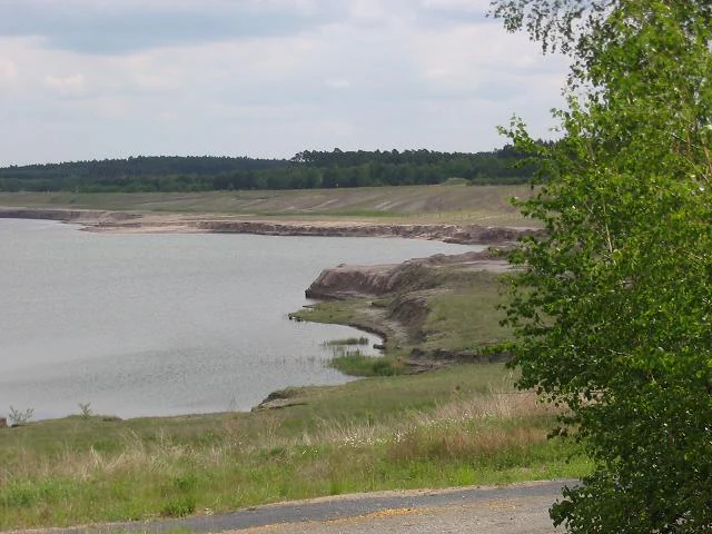
Right in the middle of this otherwise gentle landscape lies the park's most unusual terrain: roughly 7,400 hectares of former opencast mines. Today these read as a broad, sandy, partly water-filled 'moon landscape' of terraces, slopes, dunes, and new lakes. Once flooding is complete, the largest of these water bodies, the Schlabendorfer See, will be part of a contiguous water and wetland area of around 1,400 hectares, transforming the visual scale of the park once again.
Naturpark Niederlausitzer Landrücken ecosystems, habitats, and plant life
The park combines two strikingly different ecological systems within a single protected boundary. Around its edges lies a rich, well-developed mosaic of traditional Brandenburg habitats: extensive arable land in the north, meadows and pastures, fish ponds, the large forest complex of the Rochauer Heide, and strips of wetland along the small streams running north-westward off the ridge. The Rochauer Heide in particular is significant, holding old-growth-style woodland that still supports species specialists such as the Tengmalm's owl (Raufußkauz), which was adopted as the park's emblem.
At the park's center, by contrast, ecological succession has been allowed to dominate. The former mining areas, untouched for more than twenty years, have developed into a textbook succession landscape. Pioneer species, sandy substrates, dunes, fresh water, and newly forming lakes are producing conditions that essentially do not exist elsewhere in Germany at this scale. The Heinz Sielmann Stiftung, through Sielmanns Naturlandschaft Wanninchen, has acquired more than 3,200 hectares here specifically to secure these unusual habitats for the long term and to manage the area for rare species rather than for further industrial use.
The interplay of open water, swamp, dry sand, and old cultural land creates an unusual variety of ecological gradients in a small area. Dune remnants around the Schlabendorfer See, raised bogs forming in old depressions, wet meadows along new shorelines, and the older woodland of the Rochauer Heide together make the park an unusually complete example of how post-mining and traditional rural landscapes can complement each other ecologically.
Naturpark Niederlausitzer Landrücken wildlife and species highlights
Wildlife interest in the park is dominated by two zones: the older woodlands of the Rochauer Heide and the new, fast-changing habitats of the former mines. The Rochauer Heide is best known for its population of Tengmalm's owl (Raufußkauz), a reclusive forest owl that has become a symbol of the park through the old logo. The same forests support other increasingly rare woodland species typical of Brandenburg's interior pine and mixed forests.
The former mining areas have produced a completely different fauna. On the raw sand dunes and barren slopes, pioneer insects have taken hold, including the Vienna tiger beetle (Wiener Sandlaufkäfer), sand crickets, sand earwigs (Sandohrwurm), the turnip wasp (Kreiselwespe), and the blue-winged grasshopper (Blauflügelige Ödlandschrecke), alongside amphibians such as the fire-bellied toad (Rotbauchunke). Birdlife is equally remarkable: little ringed plovers (Flussregenpfeifer), northern wheatears (Steinschmätzer), lapwings (Kiebitz), a wide variety of ducks, and the largest black-headed gull (Lachmöwe) colony in Brandenburg.
The new lakes and marshes emerging from the flooded mines are particularly important for migratory and gathering waterbirds. The mining lakes around the future Schlabendorfer See already rank among the largest crane (Kranich) gathering and roosting sites in Germany, attracting thousands of cranes each season. The combination of mature forest specialists in the Rochauer Heide and large-scale, dynamic wetland and pioneer fauna in the heart of the park gives Niederlausitzer Landrücken an unusually broad profile for a Brandenburg nature park.
Naturpark Niederlausitzer Landrücken conservation status and protection priorities
From a conservation perspective, the Naturpark Niederlausitzer Landrücken is one of the most unusual success stories in eastern Germany. The park is anchored in the tradition of Germany's Naturparke, which aim to protect and develop large cultural landscapes in balance with sustainable use. In 1997 the designation pulled the area, which until then had been an exploited and then abandoned mining region, into a coordinated protection framework that combines nature conservation, recreation, education, and regional development.
The park's largest and most distinctive conservation asset is the mining wasteland at its center. Once seen as a scar on the landscape, the roughly 7,400 hectares of former opencast pits have become a hotspot for ecological succession. Groundwater rebound, together with redirected Spree water, is gradually converting pits into lakes and swamps, while the surrounding dunes and terraces offer rare habitats for specialist flora and invertebrates. These new ecosystems are now considered irreplaceable for the conservation of species such as the fire-bellied toad, the Vienna tiger beetle, and a wide array of shorebirds.
In 2000 the Heinz Sielmann Stiftung entered the park through Sielmanns Naturlandschaft Wanninchen and began systematically acquiring former mining land. Today the foundation manages more than 3,200 hectares under long-term conservation agreements, ensuring that the natural development of these habitats will not be undone by future resource extraction. Combined with the surrounding cultural landscape and the older protected forests of the Rochauer Heide, this makes the park a nationally significant conservation area for early-succession, mining-derived habitats, as well as for traditional southern Brandenburg woodlands and culturally shaped wetlands.
Naturpark Niederlausitzer Landrücken cultural meaning and human context
The park lies in the historical region of Lower Lusatia (Niederlausitz), a culturally distinct part of Brandenburg with strong Sorbian/Wendish heritage and a tradition of small rural towns, manor houses, and craftsmanship. Slawische Burgwälle, such as the hillfort near Freesdorf, are reminders that the landscape has been shaped by Slavic settlement, while later German settlement added medieval town structures, field systems, manor estates, and water mills.
Several historic villages still define the cultural character of the park. Luckau is known as the 'Pearl of the Lower Lusatia' for its medieval town wall and Gothic Nikolaikirche; it hosted the Brandenburg State Garden Show (Landesgartenschau) in the year 2000. Fürstlich Drehna centers on a moated castle (Wasserschloss) with a Lenné-designed landscape garden, while Zinnitz preserves a rare example of Schinkel-style architecture. The pottery village of Crinitz and the slavic hillfort near Freesdorf are further touchstones of regional identity.
The Höllberghof, run by the park's support association (Naturpark-Förderverein), is dedicated to maintaining rural customs and traditions, and the broader landscape of manor houses and parks, water mills, and historic agricultural villages continues to frame the wilder mining heart of the park. This blend of cultural heritage and ecological recovery is central to how the park understands itself.
Top sights and standout views in Naturpark Niederlausitzer Landrücken
A nature park rebuilt on a glacial moraine, with a steep ice-age ridge and a global model of post-mining wilderness at its core. Highlights include the future Schlabendorfer See and the surrounding mining lakes, already one of Germany's most important crane gathering and roosting sites; the old-growth woodlands of the Rochauer Heide, home to the Tengmalm's owl that gave the park its old emblem; the Lausitzer Grenzwall, the steep moraine wall dropping into the Baruther Urstromtal; and the cultural-historical villages of Luckau, Fürstlich Drehna, and Zinnitz, with their medieval townscape, Lenné garden, and Schinkel-style manor. Sielmanns Naturlandschaft Wanninchen, managed by the Heinz Sielmann Stiftung, anchors the long-term conservation of more than 3,200 hectares of former mining land inside the park.
Best time to visit Naturpark Niederlausitzer Landrücken
The park reads very differently across the seasons. Spring and early summer bring out the contrast between the green agricultural fringe and the still-bare mining core, with woodland flowers in the Rochauer Heide and breeding activity of dune specialists around the new lakes. Late summer and early autumn are particularly rewarding for birdwatching, as several thousand cranes gather and roost at the rising mining lakes, joined by large flocks of waterfowl. In winter the structure of the landscape is most visible, with frost, low water levels, and pale light emphasizing both the Lausitzer Grenzwall and the open mining hollows. The cultural villages of Luckau, Fürstlich Drehna, and Crinitz are pleasant year-round, and roughly 50 kilometers of established cycling routes cross the former mining areas, making season-by-season exploratory visits feasible throughout the warmer months.