
Mori Atlas logo
Nature reserveNaturschutzgebiet Almetal

Ecological corridors and floodplain habitats within the forested terrain of North Rhine-Westphalia

Naturschutzgebiet Almetal: Mapped Boundaries and Landscape Geography of the Alme River Valley

(Naturschutzgebiet „Almetal“)

Naturschutzgebiet Almetal preserves a vital mosaic of wet grasslands, alder-lined brook habitats, and alluvial forest fragments along the Alme river. This nature reserve, located within the North Rhine-Westphalia region, functions as a critical ecological corridor through the surrounding forested uplands. Discover the unique topography and geological features of this protected floodplain valley, including its distinctive calcareous spring deposits.

nature reserveriver valleyfloodplainwet meadowalluvial forestalder woodland
A stylized digital illustration of a green hilly landscape with patches of forest, open fields, and soft clouds in the distance.

Naturschutzgebiet Almetal

Nature reserve

Park overview

Structured park overview, official facts, and landscape profile for Almetal Nature Reserve

Almetal Nature Reserve park facts, protected area profile, and essential visitor context

Review the core facts for Almetal Nature Reserve, including designation, size, terrain, visitor scale, habitats, and operating context in one park-focused overview.

About Almetal Nature Reserve

Almetal Nature Reserve is a modest but ecologically meaningful protected landscape embedded in the larger forested area of the Briloner Hochfläche, a high plateau of the eastern Sauerland. The reserve focuses on a section of the Alme river and its floodplain, capturing a stretch of valley that, despite its small size, contains an unusually high variety of habitats. These include wet meadows, marshy grasslands, alluvial forest fragments, stream-side alder woodland, and structurally varied sections of the river itself.

The reserve's location north of the village of Alme places it in a transitional zone between the open farmland and the wider wooded uplands. Surrounded by extensive forest estates of the Hochsauerland region, the Almetal valley provides a long, narrow opening where traditional land use and natural dynamics have combined to produce a rare habitat mosaic. This combination of wet grassland, brook, and forest edge is uncommon in the region and contributes significantly to local biodiversity.

Ecologically, the area serves as a refuge for plant species associated with old meadow landscapes and calcareous spring environments. The presence of Kalksinter deposits along the brook also gives the reserve a geological dimension, recording the long-term interaction between flowing water and dissolved minerals in the area's bedrock. Together with the adjacent Almetal nature reserve across the district border, the protected area forms part of a larger landscape corridor along the Alme river that extends from Brilon into the Paderborn district.

Quick facts and research context for Almetal Nature Reserve

Almetal Nature Reserve covers roughly 94 hectares in the municipality of Brilon, in the Hochsauerland district of North Rhine-Westphalia. It protects the Alme river and its floodplain north of the village of Alme. It was formally designated in 2008 under the Briloner Hochfläche landscape plan. It belongs to the FFH site „Wälder und Quellen des Almetals“ and, since 2023, to the Natura 2000 bird protection area „Diemel- und Hoppecketal mit angrenzenden Wäldern.“

Protection and recognition

Documented terrestrial conservation framework and official recognition records

Naturschutzgebiet Almetal Protection Status and Designation History

Naturschutzgebiet Almetal maintains a documented terrestrial protection status established in 2008 within official conservation records. Comprehensive designation data details the established management scope and international recognition status for the protected area.

Protection details

Protection scope
Terrestrial
Designated year
2008
Transboundary protection
No
WDPA ID
162067
Park context

Deeper park guide and search-rich context for Almetal Nature Reserve

Almetal Nature Reserve history, landscape, wildlife, and travel context

Explore Almetal Nature Reserve through its history, landscape character, ecosystems, wildlife, conservation priorities, cultural context, and seasonal travel timing in a structured park guide built for atlas discovery and search intent.

Why Almetal Nature Reserve stands out

Almetal Nature Reserve is best known for its wet grassland mosaic, floodplain forest fragments, and alder-lined brook sections along the Alme river. It is also noted for the presence of calcareous spring deposits (Kalksinter) that record the area's geological history. The reserve stands out as an ecologically valuable green valley within the broader, mostly forested Sauerland region.
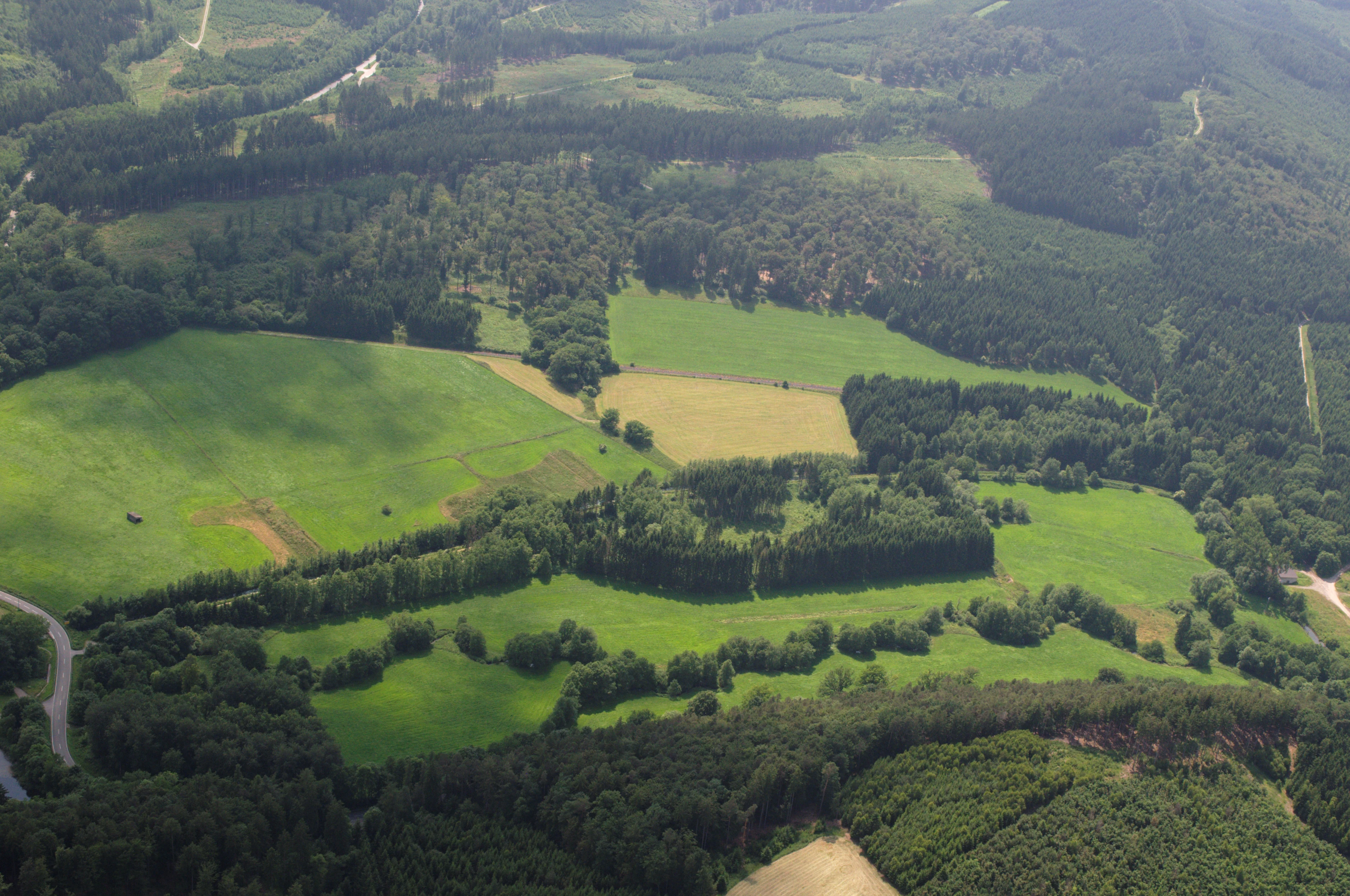
An aerial view showing a patchwork of green meadows, dense forest patches, and a winding river valley in a rural setting.
Aerial view of the landscape within the Almetal nature reserve, featuring a mosaic of meadows, swamp forests, and winding river segments.

Almetal Nature Reserve history and protected-area timeline

The Alme river valley north of Alme had long supported traditional meadow and pasture use, but it was not formally protected as a nature reserve until the late 20th century. Initial protection elements date back to 1992, while the present, more comprehensive designation came in 2008, when the Hochsauerland district formalized the area under the landscape plan for the Briloner Hochfläche.

In 2008, the district designated the Almetal floodplain as a Naturschutzgebiet to preserve its mosaic of wet grassland, alluvial forest remnants, and stream habitats. The reserve was also integrated into the EU Natura 2000 network as part of the FFH site „Wälder und Quellen des Almetals," linking it to broader European habitat protection efforts. A further step came in 2023, when the area was included in the bird protection area „Diemel- und Hoppecketal mit angrenzenden Wäldern," reflecting its recognized value for bird species as well as plants and habitats.

Almetal Nature Reserve landscape and geographic character

The landscape of the Almetal Nature Reserve is defined by a narrow river valley cutting through the forested uplands of the eastern Sauerland. At its center runs the Alme, a small river that has shaped a clearly defined floodplain corridor. The valley floor alternates between open meadow stretches, denser wooded sections, and marshy areas, creating a varied topography within a relatively small area.

Surrounding the valley, the terrain rises into the wide, forested plateau of the Briloner Hochfläche. This contrast between the sheltered valley and the exposed upland forests is a defining element of the scenery. Along the river and its small tributaries, the ground becomes wetter, with spring-fed patches that occasionally leave mineral deposits of Kalksinter. These pale, layered formations give small sections of the landscape a distinctive geological character.

The result is a landscape pattern in which a continuous green corridor of meadows, alder stands, and wet woodland threads its way through an otherwise closed forest landscape. This structural contrast between open valley and closed forest is the most recognizable physical feature of the reserve.

Almetal Nature Reserve ecosystems, habitats, and plant life

The ecological character of Almetal Nature Reserve is built around the gradient between the Alme river and the surrounding forests. The floodplain supports a sequence of wetland habitats, from wet and marshy grasslands to alder-dominated brook-side woodland and isolated remnants of alluvial forest. These habitats form a small-scale mosaic shaped both by natural river dynamics and by traditional management.

Vegetation in the wetter areas includes sedge-rich communities, rush patches, and a variety of moisture-loving herb species. The drier parts of the valley transition into species-rich meadows where traditional mowing practices help maintain botanical diversity. Springs and seepage zones along the brook add further habitat variation, often associated with calcareous conditions that allow specialized plants to thrive.

In the broader landscape context, the reserve functions as a habitat island and ecological corridor. The narrow, ecologically rich valley links larger forest blocks along the Alme river and provides connectivity for wildlife moving between the Briloner Hochfläche and the lower regions toward Paderborn. Its integration into the Natura 2000 network underlines its role within European habitat conservation.

Almetal Nature Reserve wildlife and species highlights

Because Almetal Nature Reserve is primarily valued for its habitats rather than as a wildlife spectacle, most animal interest is tied to species that depend on wet meadows, brooks, and structurally varied small-scale landscapes. Brook-side alder woodland and wet grassland provide typical habitats for insects, amphibians, and small mammals associated with Sauerland stream valleys.

The integration of the reserve into the bird protection area „Diemel- und Hoppecketal mit angrenzenden Wäldern" in 2023 reflects the presence of bird species connected to the wider forest and valley landscape of the region. The combination of open meadows, watercourses, and surrounding forest makes the valley attractive to typical woodland and farmland bird species, though detailed species-level information is not well developed in available sources.

Overall, the reserve's wildlife value lies less in the presence of single iconic animals and more in how its habitat mosaic supports a rich community of less conspicuous species, particularly those dependent on wet meadows and small watercourses.

Almetal Nature Reserve conservation status and protection priorities

From a conservation perspective, Almetal Nature Reserve is significant as a small but ecologically rich refuge within a region dominated by large-scale forest. Its main role is to preserve grassland, wetland, and brook habitats that have become rare in the modern landscape, including wet and marshy meadows, alluvial forest remnants, and stream-side alder woodland.

The reserve's protection objectives combine the preservation of these habitats with their active optimization, addressing the long-term needs of the species and communities they support. An additional focus is the protection of calcareous spring deposits (Kalksinter), which are valued for their geo-scientific and regional historical interest.

As part of the Natura 2000 network, the reserve contributes to broader European efforts to maintain coherent systems of protected areas. Its location along the Alme river also gives it a corridor function, connecting protected landscapes across district boundaries.

Almetal Nature Reserve cultural meaning and human context

The Almetal valley has historically been shaped by traditional agricultural land use, particularly meadow cultivation and grazing along the river floodplain. This long continuity of low-intensity grassland management has been central to maintaining the biodiversity the reserve now protects, and it is acknowledged in the cultural landscape classifications maintained by the Landschaftsverband Westfalen-Lippe. The valley's recognition as a regionally significant cultural landscape reflects the interplay between human land use and the natural features of the Alme river corridor.

Top sights and standout views in Almetal Nature Reserve

Key highlights of Almetal Nature Reserve include its mosaic of wet and marshy grasslands, fragments of alluvial forest, and stream-side alder woodland, all set within a forested highland landscape. Its calcareous spring deposits add a distinctive geological dimension to its ecological profile, while its integration into both the FFH site „Wälder und Quellen des Almetals" and a Natura 2000 bird protection area underscores its broader conservation relevance. Together with the adjacent Almetal protected area across the district border, it forms part of a continuous ecological corridor along the Alme river.

Best time to visit Almetal Nature Reserve

Because Almetal Nature Reserve is a quiet, habitat-focused protected area rather than a major tourist attraction, seasonal timing mostly affects the character of the landscape and the visibility of its features. Late spring and early summer are typically the most rewarding periods, when wet meadows and brook-side vegetation are at their richest and flowering plant diversity is most apparent. Late summer and early autumn remain attractive for observing the structural contrast between open valley and surrounding forest, and for experiencing the broader Sauerland upland atmosphere. Winter visits are generally quieter and emphasize the wooded character of the wider landscape.

Monthly climate preview

Long-term representative temperature and precipitation averages for Naturschutzgebiet Almetal

Naturschutzgebiet Almetal Climate Normals and Annual Temperature Patterns

Historical data records the annual temperature progression and daily precipitation rates across twelve measured intervals at a representative coordinate within Naturschutzgebiet Almetal. Reviewing the complete monthly climate profile provides deeper context on long-term thermal ranges and precipitation norms across the protected landscape.
Annual mean9 °C
0 °C18 °C
Jan
Feb
Mar
Apr
May12°
Jun15°
Jul18°
Aug18°
Sep14°
Oct
Nov
Dec
Warmest month
July

18 °C

Coolest month
January

-0.2 °C

Wettest month
July

2.6 mm/day

Driest month
April

1.7 mm/day

Park location guide

Geography guide, regional context, and park location map for Almetal Nature Reserve

Almetal Nature Reserve park geography, regions, and map view in Germany

Understand where Almetal Nature Reserve sits in Germany through a broader geographic reading of the surrounding landscape, nearby location context, and its mapped position within the national park landscape.

How Almetal Nature Reserve fits into Germany

Germany is a federal republic in Western and Central Europe with a population of over 83 million across sixteen constituent states. It is Europe's largest economy by nominal GDP and a major global exporter and importer. The capital is Berlin, and the country borders Denmark, Poland, Czech Republic, Austria, Switzerland, France, Luxembourg, Belgium, and the Netherlands.

Wider geography shaping Almetal Nature Reserve in Germany

Germany is located in Western and Central Europe, spanning 357,022 km². It borders Denmark to the north, Poland and the Czech Republic to the east, Austria and Switzerland to the south, and France, Luxembourg, Belgium, and the Netherlands to the west. The country has coastlines on the Baltic Sea and North Sea to the north, with the Alps located in the southern region.

Map view of Almetal Nature Reserve

Use this park location map to pinpoint Almetal Nature Reserve in Germany, understand its exact geographic position, and read its mapped placement within the surrounding landscape more clearly.

Pigeon | © OpenStreetMap contributors

Location context for Almetal Nature Reserve

Nordrhein-Westfalen

Visual exploration of river valleys, wet meadows, and forest fringes in Germany

Naturschutzgebiet Almetal Photos, Scenery, and Protected Landscape Views

Visual records capture the distinctive topography, floodplain habitats, and alder-lined brooks defining Naturschutzgebiet Almetal. Detailed photography reveals the striking contrast between open valley meadows and the surrounding forested plateau.

An aerial view showing a patchwork of green meadows, dense forest patches, and a winding river valley in a rural setting.

Park atlas

Compare adjacent river valleys and regional conservation landscapes across the Sauerland uplands

Explore Other Parks Near Naturschutzgebiet Almetal and Surrounding Protected Areas

Continue exploring protected areas near Naturschutzgebiet Almetal to compare surrounding river valleys, wetland mosaics, and upland forest reserves. Broaden your geographic perspective by examining connected ecological corridors and regional nature reserves throughout the district.
A horizontal watercolor painting showing rolling, abstract hills with patches of green, yellow, and soft red, accented with stylized coniferous forest lines.
Nature reserveNordrhein-Westfalen
About 1 km away#1 closest

Northeast

Leiberger Wald Nature Reserve: Protected Woodland and Stream Geography in Paderborn

A mapped forest complex within the Nordrhein-Westfalen landscape

Leiberger Wald encompasses an extensive series of beech forests and riparian habitats that form a key protected node in the Kreis Paderborn. As a significant nature reserve, the area supports a wide range of woodland and aquatic species, serving as a critical refuge within the broader ecological network of western Germany.

Area
17.86 km²
Established
1994
IUCN
IV
A horizontal watercolor painting showing a green valley with a winding river, rolling hills in the background, and grassy foreground.
Nature reserveNordrhein-Westfalen
About 5 km away#2 closest

Southwest

Naturschutzgebiet Oberes Möhnetal: Protected Floodplain and River Corridor Geography

A restored riparian landscape in Nordrhein-Westfalen

Located in the Sauerland, Naturschutzgebiet Oberes Möhnetal preserves an 81-hectare floodplain characterized by its successful LIFE+ river restoration. The area features a complex transition from meandered stream channels to wet meadows and alluvial woodlands, illustrating process-based conservation within the regional Natura 2000 corridor.

Area
0.812 km²
Established
2008
A wide, pale watercolor illustration showing rolling green and yellow hills with scattered trees.
Nature reserveHochsauerlandkreis
About 7.9 km away#3 closest

South

Naturschutzgebiet Scheffelberg / Kalberstert: Mapped Limestone Hill Landscape

Nature reserve located within the Hochsauerlandkreis regional geography

Analyze the topographic features of the Naturschutzgebiet Scheffelberg / Kalberstert, including its conical rock outcrops and expansive dry grasslands. This protected area offers a clear look at the limestone hill systems defining this part of Hochsauerlandkreis, highlighting the intersection of beech woodland and open rocky terrain through detailed geographic mapping.

Area
0.456 km²
Established
2008
Relief
Upland
Climate
Temperate
A wide watercolor-style illustration of a soft landscape featuring rolling green hills, scattered forest patches, and pale pink mountains in the background with a light sky.
Nature reserveNorth Rhine-Westphalia
About 8.1 km away#4 closest

Southeast

Hollenloch Nature Reserve: Karst Cave Systems and Protected Limestone Woodland Geography

Exploration of subterranean geology and regional karst habitats

Hollenloch stands as one of the longest and deepest cave systems within the Sauerland, developed inside dense Upper Devonian reef limestone. This protected site integrates surface karst features like the Schwalgloch with specialized forest ecosystems, providing a vital subterranean refuge for diverse bat species and a rich record of prehistoric human activity.

Area
0.032 km²
Established
2001
Relief
Upland
Climate
Temperate
A watercolor painting showing a soft, peaceful landscape with a small body of water in the foreground, surrounded by grassy banks and low hills in the distance.
Nature reserveHochsauerlandkreis
About 8.5 km away#5 closest

South

Naturschutzgebiet Schwarzes Haupt: A Protected Limestone Landscape in Hochsauerlandkreis

Mapped calcareous grasslands and orchid-rich beech forests.

This nature reserve covers 9.8 hectares of the Schwarze Haupt hill, featuring a layered terrain of rocky outcrops, former quarry remnants, and rare grassland habitats. It serves as a critical site for regional biodiversity, linking calcareous ecosystems within the eastern Sauerland through its specialized beech forests and limestone cliff formations.

Area
0.098 km²
Established
2008
Relief
Upland
Scope
Terrestrial
A soft watercolor painting of a rolling rural landscape with distant hills, scattered trees, and pastoral fields in shades of green, yellow, and red.
Protected landscapeHochsauerlandkreis
About 9.7 km away#6 closest

Southwest

Landschaftsschutzgebiet Briloner Kalkplateau und Randhöhen: Protected Area Geography

Limestone plateau and mining heritage in Hochsauerlandkreis

Discover the geographic character of Landschaftsschutzgebiet Briloner Kalkplateau und Randhöhen, a significant protected area covering upland forests and limestone terrain. Analyze its role as a buffer zone and the historical influence of regional mining on its mapped surface and natural landscape structure.

Area
16.578 km²
Established
2008
Relief
Upland
Climate
Temperate
A horizontal watercolor illustration of a soft, hazy valley with rolling green hills, distant treelines, and wildflowers in the foreground.
Nature reserveNorth Rhine-Westphalia
About 10 km away#7 closest

East

Naturschutzgebiet Aabachtal Nature Reserve and Sauerland Protected Stream Valley Geography

A preserved fluvial landscape in North Rhine-Westphalia

Naturschutzgebiet Aabachtal is a protected nature reserve in the northern Sauerland of North Rhine-Westphalia. Centered on the Aabach stream, it protects a classic Mittelgebirge valley landscape defined by meandering watercourses, lush floodplain meadows, and deciduous forest slopes, serving as a critical habitat for specialized moisture-loving flora and diverse riparian fauna.

Area
0.716 km²
Established
2001
Relief
Upland
Scope
Terrestrial
Protected landscapeKreis Paderborn
About 10 km away#8 closest

North

Landschaftsschutzgebiet FFH-Gebiet Wälder bei Büren: Regional Protected Forest Landscapes

Geographic map and protected area context in Kreis Paderborn

Landschaftsschutzgebiet FFH-Gebiet Wälder bei Büren functions as a European-level habitat site defined by its interconnected beech forest mosaic. The area is characterized by a mix of woodruff and rough blue-grass beech woodland, interwoven with intermittent stream courses, source areas, and geological sinkholes that create varied microhabitats within the North Rhine-Westphalia landscape.

Area
28.045 km²
Established
2007
Relief
Upland
Climate
Temperate

Common questions about visiting, size, designation, and location context for Almetal Nature Reserve

Almetal Nature Reserve FAQs for park facts, access, geography, and protected area context

Find quick answers about Almetal Nature Reserve, including protected-area facts, park geography, trail and visitor context, and how the park fits into its surrounding country and regional landscape.
MoriAtlas Explorer

Continue Your Protected Areas Search Across the Global Atlas

Deepen your exploration by continuing the structured search for national parks and protected areas worldwide. Utilize the comprehensive filtering capabilities to compare different conservation landscapes and refine your understanding of global park geography. Discover more about the distribution and characteristics of protected natural areas.

Global natural geography