
Mori Atlas logo
Nature reserveNaturschutzgebiet Oberes Diemeltal

Understanding the ecological boundaries and terrain of the upper Diemel river valley

Naturschutzgebiet Oberes Diemeltal: Protected Riverine Landscapes and Floodplain Geography

Naturschutzgebiet Oberes Diemeltal encompasses 187 hectares of preserved riverine terrain within the Hochsauerlandkreis of North Rhine-Westphalia. The reserve functions as a critical corridor for floodplain flora and riparian habitats along the free-flowing Diemel river, extending from the Diemelsee reservoir to Giershagen. This geography provides essential protection for rare meadow species and serves as an integrated component of regional conservation networks.

river valleyfloodplainnature reserveriparian woodlandbird protection areaFFH site
A flat-style digital illustration showing a winding river flowing through a green valley with stylized trees in the foreground, mountains in the background, and a waterfall cascading from a cliff.

Naturschutzgebiet Oberes Diemeltal

Nature reserve

Park overview

Structured park overview, official facts, and landscape profile for Naturschutzgebiet Oberes Diemeltal

Naturschutzgebiet Oberes Diemeltal park facts, protected area profile, and essential visitor context

Review the core facts for Naturschutzgebiet Oberes Diemeltal, including designation, size, terrain, visitor scale, habitats, and operating context in one park-focused overview.

About Naturschutzgebiet Oberes Diemeltal

Naturschutzgebiet Oberes Diemeltal is a river-focused nature reserve in the upper reaches of the Diemel valley in the eastern Sauerland. Its geography is defined by the Diemel itself, a tributary of the Weser, which flows here through a relatively natural valley between the impounded waters of the Diemelsee upstream and the more urbanized land near Marsberg downstream. The reserve captures the section where the river still retains an undeveloped floodplain, flanked by meadows, wetland margins, and stretches of alder woodland.

In spatial terms the area runs from Helminghausen, on the eastern side of the Diemelsee's compensation basin, downstream toward the Wepa Papierfabrik north of Giershagen. Beyond this point the protected character of the river continues directly into the neighboring Naturschutzgebiet Unteres Diemeltal, meaning that the two reserves together form a continuous corridor of protected river habitat through the upper Diemel catchment.

Beyond the river itself, the reserve includes segments of tributaries such as the Rhene, broadening the protected area from a linear river corridor into a more varied network of flowing water, banks, riparian woodland, and open wet meadows. This combination of river, floodplain, and adjacent forest habitats gives the reserve its ecological relevance within the Hochsauerlandkreis, where most other nature reserves are centered on forests, dry grasslands, or geological features rather than lowland river systems.

The reserve's significance has grown over time through its inclusion in European-level conservation networks. As an FFH site component it contributes to the protection of habitat types and species associated with the Diemel and Hoppecke river system, while its addition to the Diemel- und Hoppecketal bird protection area in 2023 underlines its value for breeding and migratory birds in a wooded and riverine landscape.

Quick facts and research context for Naturschutzgebiet Oberes Diemeltal

The reserve lies in the city of Marsberg within the Hochsauerlandkreis, North Rhine-Westphalia, and extends roughly from Helminghausen in the west to the vicinity of the Wepa Papierfabrik north of Giershagen in the east. It covers around 187 hectares and protects an undeveloped stretch of the Diemel river together with parts of tributary streams including the Rhene.

Designated in 2001 under the Hoppecketal landscape plan, the nature reserve has been part of the FFH site Gewässersystem Diemel und Hoppecke since 2004 and was added to the bird sanctuary Diemel- und Hoppecketal mit angrenzenden Wäldern in 2023. Renaturation work began in 2020, including the reconnection of side channels and the removal of sections of bank reinforcement to restore more natural flow dynamics.

Protection and recognition

Examine the terrestrial conservation scope and official protected area designation metrics.

Naturschutzgebiet Oberes Diemeltal Protection Status and International Recognition

Naturschutzgebiet Oberes Diemeltal maintains documented terrestrial protection status within the regional conservation network. Review the structured administrative records and verified designation parameters for this protected landscape.

Protection details

Protection scope
Terrestrial
Park context

Deeper park guide and search-rich context for Naturschutzgebiet Oberes Diemeltal

Naturschutzgebiet Oberes Diemeltal history, landscape, wildlife, and travel context

Explore Naturschutzgebiet Oberes Diemeltal through its history, landscape character, ecosystems, wildlife, conservation priorities, cultural context, and seasonal travel timing in a structured park guide built for atlas discovery and search intent.

Why Naturschutzgebiet Oberes Diemeltal stands out

The reserve is best known for protecting an undeveloped section of the upper Diemel and its floodplain in a landscape dominated by the Diemelsee reservoir and surrounding forests. Its tributaries, particularly the Rhene, give the area a branching river network where floodplain meadows, alder woods, and wetland fringes meet. It also stands out for the presence of locally rare floodplain plants such as yellow monkshood (Gelber Eisenhut) and blue monkshood (Blauer Eisenhut), which have made the Diemel valley a focus of conservation attention and plant habitat protection within the Marsberg region.
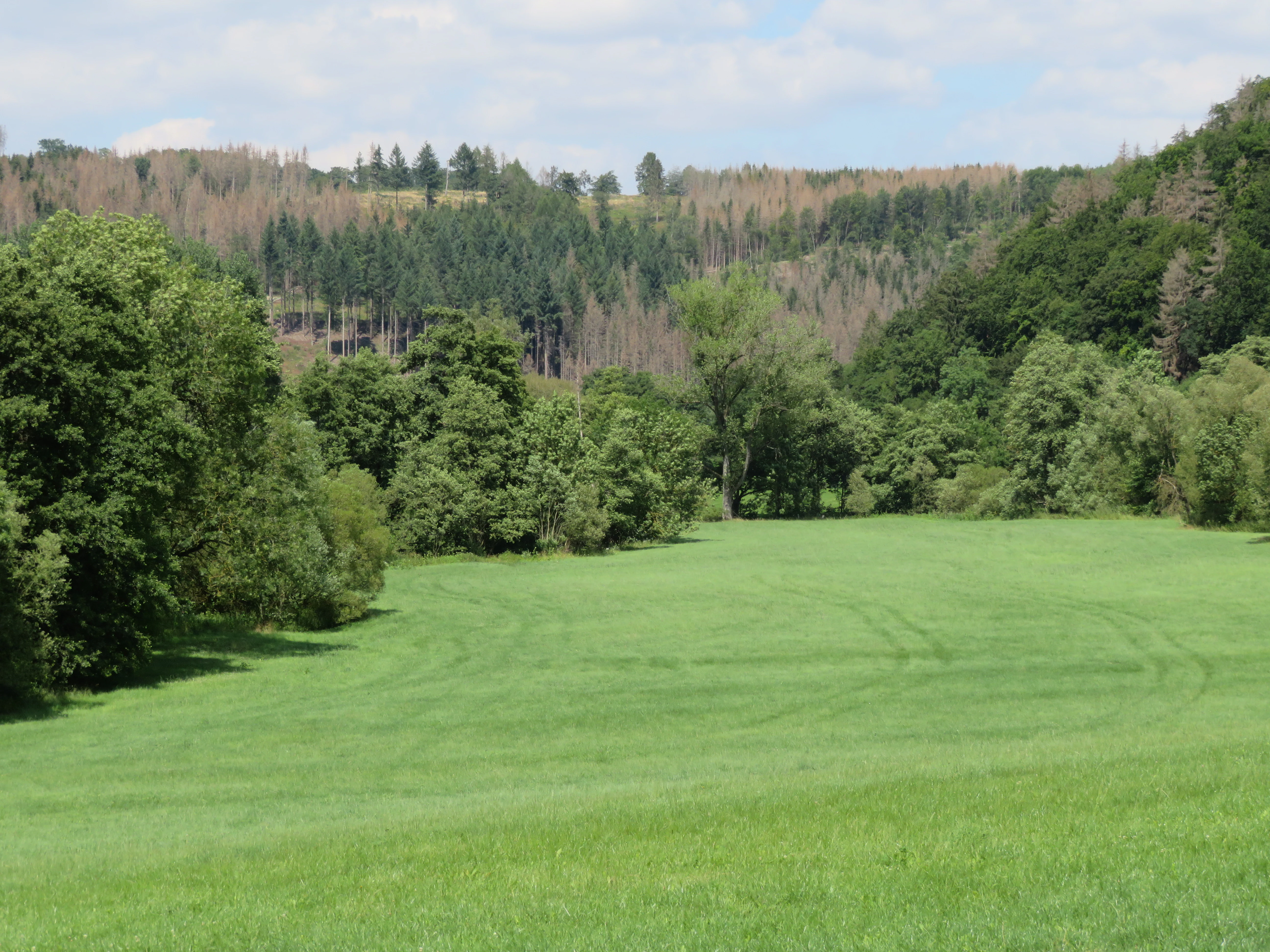
A wide, green meadow fills the foreground, leading toward a mix of dense deciduous and coniferous trees on a hilly slope in the background under a blue sky.
The valley floor of the upper Diemel river, showcasing the lush floodplain and surrounding forest within the Oberes Diemeltal nature reserve.

Naturschutzgebiet Oberes Diemeltal history and protected-area timeline

The reserve was formally designated in 2001, when the Hochsauerlandkreis incorporated it into the Hoppecketal landscape plan as a Naturschutzgebiet. This designation was preceded by recognition of the upper Diemel valley as an area of notable rarity, character, and landscape beauty, the standard criteria applied to nature reserves in Germany.

In 2004 the reserve became part of the larger FFH area Gewässersystem Diemel und Hoppecke, aligning it with the European Habitats Directive framework and broadening its conservation mandate beyond purely national protection. In 2023 it was further incorporated into the bird protection area Vogelschutzgebiet Diemel- und Hoppecketal mit angrenzenden Wäldern, reflecting the growing recognition of the Diemel valley's importance for avifauna.

Since 2020 active renaturation measures have been carried out within the reserve. In 2020 two side channels were reconnected to the main river downstream of their original outlets, and in 2021 sections of bank reinforcement were removed and large stones from the old bank protection were repositioned within the river as current deflectors. These interventions are aimed at restoring more natural flow patterns and improving habitat diversity along the Diemel.

Naturschutzgebiet Oberes Diemeltal landscape and geographic character

The landscape of the Oberes Diemeltal is shaped by the valley of the upper Diemel as it moves through the eastern Sauerland. The river here flows in a relatively open valley, bordered by floodplain meadows, alder-dominated wet woodland, and gently sloping valley edges that transition into the broader forested hills of the surrounding Hochsauerland.

The terrain reflects the transition zone between the upland character of the Sauerland and the more low-lying Diemel lowlands further downstream. Although the valley is not dramatic in relief, it is visually defined by the contrast between the flowing river and its associated water meadow vegetation on one side, and the denser mixed and coniferous forests that rise from the valley margins on the other.

Key visible landscape elements include the open Diemel channel itself, sections of tributary valley such as the Rhene, reed- and herb-rich bank vegetation, wet meadows, and pools. Upstream, the reserve is visually linked to the broader open water of the compensation basin east of the Diemelsee, while downstream it merges into the Giershagen area where industrial land use along the Wepa Papierfabrik marks the boundary of the protected landscape.

Naturschutzgebiet Oberes Diemeltal ecosystems, habitats, and plant life

Ecologically, the reserve is centered on the still semi-natural sections of the Diemel and its tributaries, together with their associated floodplain habitats. These include riparian alder woods, wet meadows, herbaceous riverbank vegetation, and small standing-water features that together form a coherent complex of riverine and wetland ecosystems.

This habitat mosaic is relatively unusual in the Hochsauerlandkreis, where forests and upland grasslands dominate the protected-area portfolio. The presence of more lowland-influenced floodplain species gives the reserve a distinctive ecological flavor compared to the surrounding protected sites.

Particular botanical importance attaches to rare floodplain plants such as yellow monkshood (Gelber Eisenhut) and blue monkshood (Blauer Eisenhut), which find suitable conditions along the Diemel's banks and adjacent meadows. The presence of such species has been one of the key arguments for protecting the valley and for active habitat management, including the removal of bank reinforcements and the restoration of side channels.

Naturschutzgebiet Oberes Diemeltal wildlife and species highlights

The reserve's wildlife interest is closely tied to its riverine and wetland habitats. The Diemel and its tributaries provide habitat for aquatic and semi-aquatic species, while the wet meadows, reed beds, and adjacent forests support a range of bird, mammal, and insect life. The designation of the valley within a bird protection area in 2023 reflects the site's recognized value for breeding and migratory birds in a landscape where forest and open water habitats intersect.

Mammals typical of wet woodland and floodplain habitats, such as wild boar, use the alder stands and meadows along the Diemel, especially where riparian cover is dense. Wildfowl are present in the river and along its margins, and the wider landscape context of forests, fields, and the nearby Diemelsee reservoir supports a diverse bird community across seasons.

The combination of flowing water, wet meadows, and fringing woodland also provides habitat for amphibians and invertebrates associated with floodplain environments, although detailed species records are not described in the available source material.

Naturschutzgebiet Oberes Diemeltal conservation status and protection priorities

The reserve's conservation significance lies in its protection of one of the less disturbed stretches of the upper Diemel and its floodplain within a region otherwise affected by reservoir management, forestry, and agricultural land use. Its designation under the Hoppecketal landscape plan, and its later integration into the FFH site Gewässersystem Diemel und Hoppecke and the Diemel- und Hoppecketal bird protection area, place it within both national and European conservation frameworks.

Active conservation management began in 2020 through renaturation measures. The reconnection of two side channels in 2020 expanded the area of flowing and standing water habitat, while the removal of bank reinforcements and the placement of flow-deflecting stones in 2021 aim to restore more natural hydrological dynamics along the Diemel.

The reserve has also faced documented threats, including illegal gold panning in the river, dumping of grain meal as wildlife bait in adjacent wetland and forest areas, and the inappropriate tipping of asphalt road rubble into nearby forest, wetland, and river habitats during local roadworks. These incidents underline the vulnerability of the floodplain habitats and the need for ongoing monitoring and enforcement by the local nature protection authority.

Naturschutzgebiet Oberes Diemeltal cultural meaning and human context

The upper Diemel valley has a long history of human use shaped by small-scale agriculture, forestry, and, more recently, industrial activity such as the Wepa Papierfabrik north of Giershagen. Traditional meadow management along the river has helped maintain the open character of the floodplain, while local hunting practices continue to interact with the reserve's wildlife management.

The area is part of the cultural landscape of the Hochsauerland, where small villages like Helminghausen and Giershagen have shaped the rural environment around the river for centuries. The contrast between this traditional rural setting and the industrial edge near the paper factory gives the protected stretch of valley a particular local identity as a remaining natural corridor within an otherwise heavily used landscape.

Top sights and standout views in Naturschutzgebiet Oberes Diemeltal

The reserve combines rare floodplain flora, a free-flowing section of the Diemel, and active renaturation measures within a compact 187-hectare area. Its location at the transition between the Diemelsee reservoir landscape and the Marsberg urban-industrial fringe gives it both ecological and landscape-planning significance, while its inclusion in the FFH network and the Diemel- und Hoppecketal bird protection area places it firmly within European conservation frameworks.

Its direct continuity with the neighboring Unteres Diemeltal reserve also makes the upper Diemel one of the more important river-focused protected-area complexes in the Hochsauerlandkreis, offering a comparatively natural river corridor in a region dominated by forests and reservoirs.

Best time to visit Naturschutzgebiet Oberes Diemeltal

The reserve is best experienced in late spring and early summer, when the floodplain meadows and riverbanks are at their most floristically rich and the foliage of alder and riparian woodland is fully developed. This period also tends to be the most rewarding for birdwatching, as breeding activity along the river and in adjacent woodland peaks.

Late summer and autumn can offer quieter conditions and a different character, with lower water levels and visible signs of management activity, while winter visits emphasize the structure of the river channel itself and the surrounding beech and mixed forests that frame the valley. Visiting conditions generally favor milder weather, as the floodplain meadows can be wet underfoot, especially after rainfall.

Monthly climate preview

Long-term temperature ranges and precipitation rhythm across the park landscape

Naturschutzgebiet Oberes Diemeltal Climate Normals and Monthly Weather Records

Historical climate data for Naturschutzgebiet Oberes Diemeltal tracks measured monthly temperature variation alongside steady precipitation levels across the representative coordinate. Reviewing the complete twelve-month profile offers a detailed look at long-term meteorological patterns across the protected terrain.
Annual mean9 °C
0 °C18 °C
Jan
Feb
Mar
Apr
May12°
Jun15°
Jul18°
Aug18°
Sep14°
Oct
Nov
Dec
Warmest month
July

18 °C

Coolest month
January

-0.2 °C

Wettest month
July

2.6 mm/day

Driest month
April

1.7 mm/day

Park location guide

Geography guide, regional context, and park location map for Naturschutzgebiet Oberes Diemeltal

Naturschutzgebiet Oberes Diemeltal park geography, regions, and map view in Germany

Understand where Naturschutzgebiet Oberes Diemeltal sits in Germany through a broader geographic reading of the surrounding landscape, nearby location context, and its mapped position within the national park landscape.

How Naturschutzgebiet Oberes Diemeltal fits into Germany

Germany is a federal republic in Western and Central Europe with a population of over 83 million across sixteen constituent states. It is Europe's largest economy by nominal GDP and a major global exporter and importer. The capital is Berlin, and the country borders Denmark, Poland, Czech Republic, Austria, Switzerland, France, Luxembourg, Belgium, and the Netherlands.

Wider geography shaping Naturschutzgebiet Oberes Diemeltal in Germany

Germany is located in Western and Central Europe, spanning 357,022 km². It borders Denmark to the north, Poland and the Czech Republic to the east, Austria and Switzerland to the south, and France, Luxembourg, Belgium, and the Netherlands to the west. The country has coastlines on the Baltic Sea and North Sea to the north, with the Alps located in the southern region.

Map view of Naturschutzgebiet Oberes Diemeltal

Use this park location map to pinpoint Naturschutzgebiet Oberes Diemeltal in Germany, understand its exact geographic position, and read its mapped placement within the surrounding landscape more clearly.

Pigeon | © OpenStreetMap contributors

Location context for Naturschutzgebiet Oberes Diemeltal

Hochsauerlandkreis

Visualizing the river valley, floodplain habitats, and protected terrain of the upper Diemel

Naturschutzgebiet Oberes Diemeltal Landscape Photos and Scenery

Visual documentation captures the free-flowing river channels, wet meadows, and riparian woodlands that define the protected landscape of Naturschutzgebiet Oberes Diemeltal. Examining these detailed photographs reveals the distinctive terrain, riverine vegetation, and conservation features of the upper Diemel catchment.

A wide, green meadow fills the foreground, leading toward a mix of dense deciduous and coniferous trees on a hilly slope in the background under a blue sky.

Park atlas

Compare nearby river valleys and connected conservation areas across the surrounding region

Other Parks Near Naturschutzgebiet Oberes Diemeltal and Regional Protected Landscapes

Browsing other parks near Naturschutzgebiet Oberes Diemeltal reveals connected river corridors, floodplain reserves, and forested watersheds throughout the Hochsauerland region. Comparing adjacent protected landscapes provides deeper geographic context for the upper Diemel valley and surrounding natural habitats.
A watercolor landscape illustration showing soft, rolling green hills, coniferous trees, and a hazy background.
Nature reserveHochsauerlandkreis
About 1.7 km away#1 closest

Northeast

Naturschutzgebiet Padberg: A Protected Landscape in the Hochsauerlandkreis Region

Diabas geology and forest habitat mapping

Naturschutzgebiet Padberg protects a compact but ecologically rich landscape of beech forests and craggy rock cliffs. Its position above the Diemel valley highlights the relationship between volcanic Diabas topography and woodland development within the Hochsauerlandkreis district.

Area
0.467 km²
Established
2001
Relief
Upland
Climate
Temperate
Nature reserveHessen
About 2.5 km away#2 closest

Southeast

Naturschutzgebiet Am Mühlenberg bei Adorf: Protected Forest and Volcanic Terrain

Geographic overview of a key Hessen nature reserve

Spanning 33 hectares in northern Hessen, Naturschutzgebiet Am Mühlenberg bei Adorf is defined by its Devonian volcanic bedrock and varied microclimates. The reserve provides a detailed look at how aspect and slope create contrasting forest communities, from dry oak stands to cool-air ravine woodland, offering a concentrated study in protected-area botanical richness.

Area
0.335 km²
Established
1992
IUCN
IV
Relief
Upland
A soft watercolor illustration showing a gentle, rolling landscape with green meadows, trees, and distant hills under a pale sky.
Nature reserveHochsauerlandkreis
About 3 km away#3 closest

East

Naturschutzgebiet Östlicher Arnstein: Protected Nature Reserve and Geographic Map

Grassland mosaic and historic terrain in Hochsauerlandkreis

Naturschutzgebiet Östlicher Arnstein comprises 8.5 hectares of species-rich meadows and hedgerow complexes nestled in the Waldecker Gefilde. This reserve offers a significant look at regional grassland conservation, providing habitat diversity through its base-rich soils and disused quarry sites. It acts as a vital transition point between the forested Sauerland slopes and the surrounding open agricultural landscape.

Area
0.085 km²
Established
2001
Relief
Lowland
Climate
Temperate
A soft watercolor painting of a serene natural landscape with rolling hills, a central body of water, and green trees against a pale, warm-toned sky.
Nature reserveWaldeck-Frankenberg
About 5.3 km away#4 closest

Southwest

Naturschutzgebiet Diemelsee Nature Reserve: Geographic Atlas and Protected Landscape

Waldeck-Frankenberg Wetland and Reservoir Margin Analysis

Located in northern Hesse, Naturschutzgebiet Diemelsee serves as a crucial protected sanctuary where the Itter stream enters the reservoir. This reserve features a distinctive mosaic of mudflats, reed beds, and swamp-like woodland, shaped by annual water level changes that create a unique habitat for local birdlife and pioneer flora within the broader Sauerland foothills.

Area
0.187 km²
Established
1965
Relief
Lowland
Scope
Terrestrial
Watercolor painting of a wide, soft-toned landscape showing gentle rolling hills, open fields, and a small meandering stream, executed in a minimalist, light-filled style.
Protected landscapeHochsauerlandkreis
About 6.1 km away#5 closest

Northeast

Landschaftsschutzgebiet Freiflächen um Giershagen: Protected Landscape and Regional Map

Agricultural cultural heritage and biodiversity in Hochsauerlandkreis

This protected area in North Rhine-Westphalia preserves 785 hectares of traditional Sauerland countryside. It features extensively managed farmland, rare arable plant habitats, and historically significant landscape structures that support regional biodiversity and long-term ecological stewardship.

Area
7.849 km²
Established
2008
Relief
Upland
Scope
Terrestrial
A wide watercolor-style illustration of a soft landscape featuring rolling green hills, scattered forest patches, and pale pink mountains in the background with a light sky.
Nature reserveNorth Rhine-Westphalia
About 6.3 km away#6 closest

West

Hollenloch Nature Reserve: Karst Cave Systems and Protected Limestone Woodland Geography

Exploration of subterranean geology and regional karst habitats

Hollenloch stands as one of the longest and deepest cave systems within the Sauerland, developed inside dense Upper Devonian reef limestone. This protected site integrates surface karst features like the Schwalgloch with specialized forest ecosystems, providing a vital subterranean refuge for diverse bat species and a rich record of prehistoric human activity.

Area
0.032 km²
Established
2001
Relief
Upland
Climate
Temperate
A horizontal watercolor illustration of a soft, hazy valley with rolling green hills, distant treelines, and wildflowers in the foreground.
Nature reserveNorth Rhine-Westphalia
About 6.5 km away#7 closest

North

Naturschutzgebiet Aabachtal Nature Reserve and Sauerland Protected Stream Valley Geography

A preserved fluvial landscape in North Rhine-Westphalia

Naturschutzgebiet Aabachtal is a protected nature reserve in the northern Sauerland of North Rhine-Westphalia. Centered on the Aabach stream, it protects a classic Mittelgebirge valley landscape defined by meandering watercourses, lush floodplain meadows, and deciduous forest slopes, serving as a critical habitat for specialized moisture-loving flora and diverse riparian fauna.

Area
0.716 km²
Established
2001
Relief
Upland
Scope
Terrestrial
A watercolor painting showing a soft, peaceful landscape with a small body of water in the foreground, surrounded by grassy banks and low hills in the distance.
Nature reserveHochsauerlandkreis
About 7.3 km away#8 closest

West

Naturschutzgebiet Schwarzes Haupt: A Protected Limestone Landscape in Hochsauerlandkreis

Mapped calcareous grasslands and orchid-rich beech forests.

This nature reserve covers 9.8 hectares of the Schwarze Haupt hill, featuring a layered terrain of rocky outcrops, former quarry remnants, and rare grassland habitats. It serves as a critical site for regional biodiversity, linking calcareous ecosystems within the eastern Sauerland through its specialized beech forests and limestone cliff formations.

Area
0.098 km²
Established
2008
Relief
Upland
Scope
Terrestrial

Common questions about visiting, size, designation, and location context for Naturschutzgebiet Oberes Diemeltal

Naturschutzgebiet Oberes Diemeltal FAQs for park facts, access, geography, and protected area context

Find quick answers about Naturschutzgebiet Oberes Diemeltal, including protected-area facts, park geography, trail and visitor context, and how the park fits into its surrounding country and regional landscape.
MoriAtlas Explorer

Continue Your Protected Areas Search Across the Global Atlas

Deepen your exploration by continuing the structured search for national parks and protected areas worldwide. Utilize the comprehensive filtering capabilities to compare different conservation landscapes and refine your understanding of global park geography. Discover more about the distribution and characteristics of protected natural areas.

Global natural geography