
Mori Atlas logo
Nature reserveNaturschutzgebiet Oelbachtal

A structurally diverse stream valley reserve defining the municipal boundary between Dortmund and Bochum

Naturschutzgebiet Oelbachtal: Mapped Protected Landscapes and Regional Biodiversity in Nordrhein-Westfalen

Naturschutzgebiet Oelbachtal represents a highly concentrated mosaic of deciduous woodland, wet meadows, and reed-fringed ponds nestled in the Oelbach stream valley. Spanning 21.8 hectares, this protected landscape serves as a vital ecological corridor in the urban Ruhr region. The terrain preserves a centuries-old cultural landscape structure, providing essential habitats for breeding birds and various amphibians within its narrow, undulating valley floor.

stream valleywet meadowsdeciduous woodlandhedgerowspondsreed beds
A colorful vector illustration of a forest scene featuring a winding stream, rocky banks, tall trees, and distant cliffs under a sun.

Naturschutzgebiet Oelbachtal

Nature reserve

Park overview

Structured park overview, official facts, and landscape profile for Naturschutzgebiet Oelbachtal

Naturschutzgebiet Oelbachtal park facts, protected area profile, and essential visitor context

Review the core facts for Naturschutzgebiet Oelbachtal, including designation, size, terrain, visitor scale, habitats, and operating context in one park-focused overview.

About Naturschutzgebiet Oelbachtal

Naturschutzgebiet Oelbachtal occupies the valley floor of the Oelbach, a small stream in the western Ruhr region of North Rhine-Westphalia. Located within the Lütgendortmund district of Dortmund, the reserve sits on the city boundary with Bochum-Harpen and forms the downstream section of a longer protected corridor that continues upstream into the Naturschutzgebiet Oberes Oelbachtal. While small at roughly 21.8 hectares, the reserve makes a disproportionate local contribution to biodiversity conservation because of the structural complexity of its habitats.

The defining character of the Oelbachtal is its ecological mosaic. Rather than being dominated by a single habitat type, the valley contains a rich mixture of deciduous woodland, scattered trees, hedgerow strips, wet meadows, ponds, and small standing waters, all woven together around the Oelbach and several of its tributaries. Reed fringes line the watercourses, woodland edges border the meadows, and small pools and ditches add further elements of moisture variation. The result is a landscape that shifts repeatedly between dry and wet, open and wooded, creating edge effects and transitions that are highly valuable for wildlife.

This structural diversity is reflected in the reserve's fauna. More than forty species of birds breed in the Oelbachtal, including familiar woodland and edge species such as wrens, hedge accentors, pheasants, and great spotted woodpeckers, alongside more habitat-specific species such as water rail, whinchat, grasshopper warbler, and hobby falcon. The combination of wet meadows, ponds, and flowing water also supports a rich amphibian community, with species such as alpine newt, smooth newt, common toad, common frog, and pool frog present, along with reptiles like slow worm and viviparous lizard. The presence of the pond mussel is considered an exceptional feature within this small reserve.

Although the reserve lies in an urbanized landscape, it is classified as a regionally significant cultural landscape area, recognizing centuries of human interaction with the Oelbach valley, including traditional meadow use, milling, and settlement along the stream. Today, the main conservation challenges include progressive drying of soils, expansion of tall herbs such as nettles, and pressure from visitors, particularly walkers with dogs passing through the narrow valley.

Quick facts and research context for Naturschutzgebiet Oelbachtal

The Naturschutzgebiet Oelbachtal is a small stream-valley nature reserve in Dortmund's Lütgendortmund district, North Rhine-Westphalia, established in 1986. It covers approximately 21.8 hectares and is officially classified under the German Naturschutzgebiet framework, corresponding to IUCN Category IV as a habitat and species management area. The reserve is managed under the designation DO-009 and is catalogued in the World Database on Protected Areas under ID 164920.

The reserve follows the Oelbach, a small stream that historically carried many local names and ultimately flows into the Ruhr. Its position on the Dortmund-Bochum boundary gives it direct ecological continuity with the larger Naturschutzgebiet Oberes Oelbachtal, and together they form a connected corridor of protected valley habitat in an otherwise densely urbanized region of the Ruhr.

Protection and recognition

Examine the documented conservation records and international registry data for this protected area.

Naturschutzgebiet Oelbachtal Protection Status and Protected Area Designation

Naturschutzgebiet Oelbachtal holds official protected area designation entries within the global conservation database framework. Documented protection status details provide clear insight into registered boundaries and administrative records.

Protection details

WDPA ID
164920
Park context

Deeper park guide and search-rich context for Naturschutzgebiet Oelbachtal

Naturschutzgebiet Oelbachtal history, landscape, wildlife, and travel context

Explore Naturschutzgebiet Oelbachtal through its history, landscape character, ecosystems, wildlife, conservation priorities, cultural context, and seasonal travel timing in a structured park guide built for atlas discovery and search intent.

Why Naturschutzgebiet Oelbachtal stands out

Naturschutzgebiet Oelbachtal is best known for its unusually high habitat diversity compressed into a narrow stream valley. Within a small area, the reserve combines deciduous woodland, hedgerows, wet meadows, ponds, and reed-fringed watercourses, producing a mosaic that supports more than forty breeding bird species and a varied amphibian fauna. The reserve is also distinguished by its role as a surviving example of a historically intensively used valley landscape embedded in the urban Ruhr region. Its connection to the neighbouring Oberes Oelbachtal reserve and its recognition as a regionally significant cultural landscape area add a further layer of identity, positioning it as both a biodiversity refuge and a piece of living regional heritage between Dortmund and Bochum.
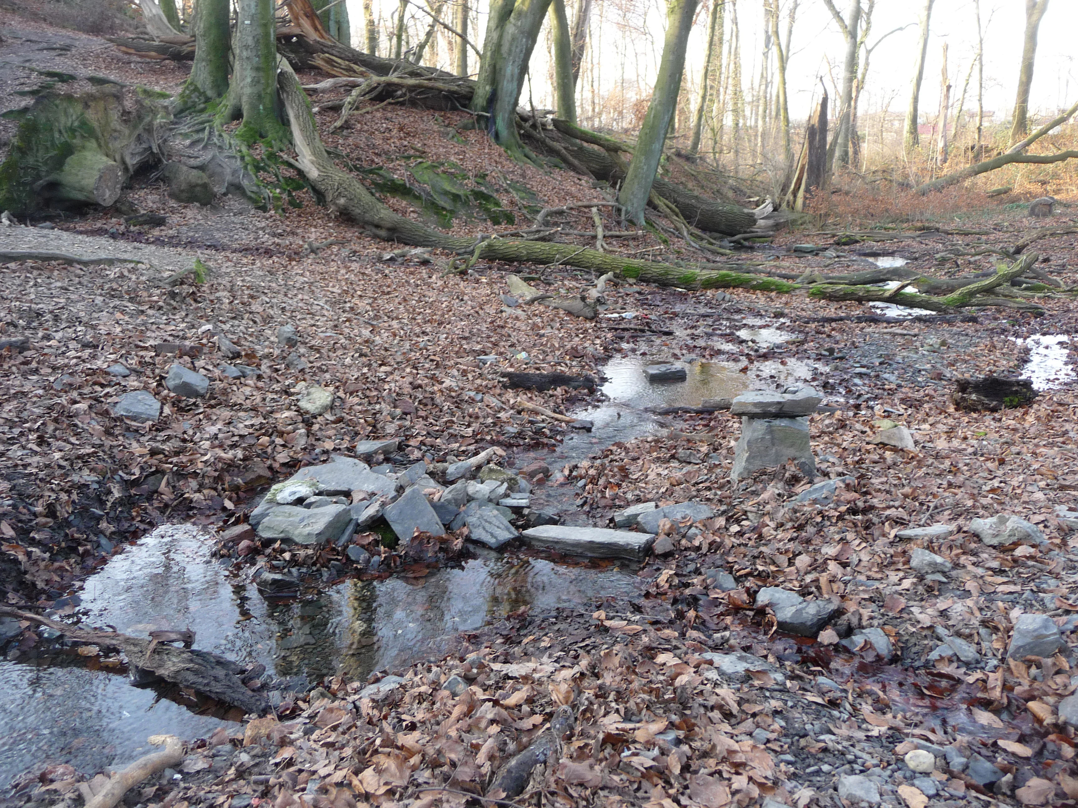
A forest floor covered in brown leaves with small puddles of water and scattered grey rocks, with bare trees in the background.
View of the forest floor and stream bed in the Oelbachtal nature reserve, featuring fallen leaves, puddles, and scattered rocks.

Naturschutzgebiet Oelbachtal history and protected-area timeline

The Naturschutzgebiet Oelbachtal was first placed under protection by the Bezirksregierung Arnsberg through a temporary safeguarding order on 19 June 1986. This initial designation provided interim protection while longer-term planning took shape, reflecting the increasing recognition of small stream-valley habitats as important refuges within the heavily urbanized Ruhr region.

On 19 January 1996, the reserve was formally incorporated into the Dortmund-Mitte Landscape Plan, giving it permanent status within the regional framework of protected areas. This step aligned the Oelbachtal with the broader network of nature reserves and landscape planning instruments used across North Rhine-Westphalia, and confirmed its long-term role as a protected habitat and species management area. The reserve was later registered in international databases under IUCN Category IV and remains managed under the designation DO-009.

Naturschutzgebiet Oelbachtal landscape and geographic character

The landscape of the Oelbachtal is shaped by a small, slow-moving stream that has carved a modest valley through the surrounding plateau. The terrain is gently undulating rather than dramatic, but the valley form itself creates the defining structure of the reserve, concentrating moisture, vegetation variation, and habitat transitions into a relatively narrow corridor.

Within this valley setting, woodland patches, isolated trees, and hedgerow strips alternate with open wet meadows and small ponds that fill natural depressions and former fishpond basins. Reed beds line the edges of the Oelbach and its tributaries, while woodland fringes edge the open ground. The result is a finely textured landscape in which changes between wet and dry, open and shaded, are short and frequent, creating the structural variety that defines the reserve's ecological character. Despite real pressures from encroaching tall herbs and gradual drying of soils, the valley retains a clearly recognizable mosaic of habitats typical of historically managed small-stream landscapes in western Germany.

Naturschutzgebiet Oelbachtal ecosystems, habitats, and plant life

Ecologically, the Oelbachtal represents a textbook example of a small but structurally rich stream-valley habitat complex. The reserve functions as a habitat and species management area, prioritizing the maintenance of specific habitat types and their associated species rather than the protection of a single large untouched ecosystem.

Vegetation patterns in the reserve reflect the alternating wet and dry conditions of the valley. Deciduous woodland, in some cases dominated by native broadleaf species, covers parts of the slopes and fringes, while wet meadows and tall-herb vegetation occupy the flatter valley floor. Ponds and ditches contribute small-scale aquatic and semi-aquatic vegetation communities, and reed beds form transitional zones between open water and terrestrial habitats. The variety of vegetation types within such a small area produces a network of ecological gradients that supports a wide range of invertebrates, amphibians, and birds.

The reserve's biodiversity value is closely tied to this habitat fragmentation in a positive sense: the frequent changes between habitat types and the presence of water in multiple forms create conditions for many species that would not find suitable living space in a more uniform or drier landscape.

Naturschutzgebiet Oelbachtal wildlife and species highlights

Wildlife is one of the most striking features of the Oelbachtal given its compact size. More than forty bird species breed in the reserve, taking advantage of the mixture of woodland, scrub, meadow, and water. Among the breeding species are wren, hedge accentor, pheasant, water rail, whinchat, grasshopper warbler, cuckoo, melodious warbler, chiffchaff, willow warbler, and great spotted woodpecker, reflecting the importance of reed beds, hedgerows, woodland edges, and open meadows within the valley.

Amphibians are particularly well represented because of the abundance of ponds, ditches, and slow-moving water. Alpine newt, smooth newt, common toad, common frog, and pool frog all inhabit the reserve, making it a valuable local stronghold for amphibian reproduction in the urban Ruhr landscape. Reptiles such as slow worm and viviparous lizard add to the faunal diversity.

A particularly notable occurrence is the presence of the pond mussel, an aquatic invertebrate whose occurrence in such a small urban-adjacent stream valley is considered ecologically remarkable. The combination of rich bird, amphibian, reptile, and invertebrate fauna in a reserve of only around 21 hectares highlights how habitat diversity can compensate for limited overall size.

Naturschutzgebiet Oelbachtal conservation status and protection priorities

From a conservation perspective, the Naturschutzgebiet Oelbachtal is significant because it preserves a complex mosaic of valley habitats within a heavily urbanized region between Dortmund and Bochum. As a formally protected nature reserve under German law, it is classified as a habitat and species management area, with objectives focused on maintaining existing habitat structures and the species they support rather than restoring a particular historical condition.

The protection goals emphasize the preservation of habitat gradients from wet to dry and the conservation of reed beds, ponds, and watercourse margins. The reserve's management plan also calls for the existing fishpond to be redesigned in a more naturalistic state, and for visitor management measures to reduce disturbance to breeding birds, especially from walkers and dogs using the narrow valley.

Current conservation challenges include progressive drying of soils in parts of the valley, the spread of tall herbs such as stinging nettle, and ongoing pressure from recreational users. The reserve is also recognized as a regionally significant cultural landscape area, underscoring the link between ecological and cultural values in the long-term protection of the Oelbachtal.

Naturschutzgebiet Oelbachtal cultural meaning and human context

The Oelbach valley has a long history of human use that is woven into the landscape of the reserve itself. The stream itself has carried numerous historical names over the centuries, including Meeßbach, Blennebach, Mühlenbach, Sprikel, Wiescherbach, Dorfbach, Hevener Bach, and Aulbach, with derived forms meaning swamp or wetland. These names point to a long tradition of small-scale water management, milling, and settlement along the stream.

The valley has been classified as a regionally significant cultural landscape area, reflecting the layered history of meadows, fishing ponds, mills, and rural settlements that shaped the Oelbach valley across generations. While the modern reserve is focused primarily on ecological protection, the persistence of these historical land-use patterns in the form of meadows, ponds, and woodland edges gives the Oelbachtal a distinctive cultural as well as natural character within the Ruhr region.

Top sights and standout views in Naturschutzgebiet Oelbachtal

Compact but structurally rich stream-valley reserve on the Dortmund-Bochum boundary. Protected habitat mosaic of woodland, hedgerows, wet meadows, ponds, and reed beds. More than forty breeding bird species recorded within the 21.8-hectare area. Strong amphibian fauna including newts, frogs, and toads linked to abundant ponds and ditches. Recognized as a regionally significant cultural landscape area rooted in centuries of small-stream land use.

Best time to visit Naturschutzgebiet Oelbachtal

Spring and early summer are generally the most rewarding periods for experiencing the Oelbachtal, when breeding birds are active across the valley, amphibian populations are at their most visible around the ponds and ditches, and the mix of woodland, meadow, and wetland is in full growth. Reed beds and wet meadows are particularly alive during these months.

Late spring is also a good period to observe the reserve's birdlife, including warblers and reed-associated species, while early morning visits reduce the chance of disturbance to breeding birds. Autumn can offer a quieter experience with subtle changes in the deciduous woodland and meadows, though some wetland areas may draw down. The reserve's small size makes short, low-impact visits appropriate throughout the milder months.

Monthly climate preview

Measured long-term monthly temperature and precipitation averages for a representative coordinate

Naturschutzgebiet Oelbachtal Climate Normals and Annual Temperature Rhythm

Representative coordinate records show average monthly temperatures ranging from near freezing to warm summer highs alongside steady precipitation throughout the year. Examining the full monthly climate normals provides a clearer look at the long-term weather patterns recorded across Naturschutzgebiet Oelbachtal.
Annual mean9 °C
1 °C19 °C
Jan
Feb
Mar
Apr
May13°
Jun16°
Jul19°
Aug18°
Sep14°
Oct10°
Nov
Dec
Warmest month
July

18.5 °C

Coolest month
January

0.9 °C

Wettest month
December

3 mm/day

Driest month
April

1.7 mm/day

Park location guide

Geography guide, regional context, and park location map for Naturschutzgebiet Oelbachtal

Naturschutzgebiet Oelbachtal park geography, regions, and map view in Germany

Understand where Naturschutzgebiet Oelbachtal sits in Germany through a broader geographic reading of the surrounding landscape, nearby location context, and its mapped position within the national park landscape.

How Naturschutzgebiet Oelbachtal fits into Germany

Germany is a federal republic in Western and Central Europe with a population of over 83 million across sixteen constituent states. It is Europe's largest economy by nominal GDP and a major global exporter and importer. The capital is Berlin, and the country borders Denmark, Poland, Czech Republic, Austria, Switzerland, France, Luxembourg, Belgium, and the Netherlands.

Wider geography shaping Naturschutzgebiet Oelbachtal in Germany

Germany is located in Western and Central Europe, spanning 357,022 km². It borders Denmark to the north, Poland and the Czech Republic to the east, Austria and Switzerland to the south, and France, Luxembourg, Belgium, and the Netherlands to the west. The country has coastlines on the Baltic Sea and North Sea to the north, with the Alps located in the southern region.

Map view of Naturschutzgebiet Oelbachtal

Use this park location map to pinpoint Naturschutzgebiet Oelbachtal in Germany, understand its exact geographic position, and read its mapped placement within the surrounding landscape more clearly.

Pigeon | © OpenStreetMap contributors

Location context for Naturschutzgebiet Oelbachtal

Nordrhein-Westfalen

Visual reference collection showcasing valley terrain, wetland habitats, and stream ecology.

Naturschutzgebiet Oelbachtal Photos, Scenery, and Protected Landscape Views

Visual records document the complex stream valley mosaic, capturing deciduous woodland patches, wet meadows, and small ponds across the protected corridor. Photographic coverage illustrates the underlying terrain and habitat transitions that define the ecological identity of the reserve.

A forest floor covered in brown leaves with small puddles of water and scattered grey rocks, with bare trees in the background.

Park atlas

Compare surrounding regional geography and connected stream-valley nature reserves

Explore Protected Areas and Nearby Parks Like Naturschutzgebiet Oelbachtal

Browsing other protected areas near Naturschutzgebiet Oelbachtal reveals a wider network of urban-adjacent stream valleys and wetland reserves across the Ruhr region. Examining adjacent natural habitats provides essential context for comparing local biodiversity patterns and regional conservation landscapes.
A wide watercolor illustration showing a green riverbank, a stream, distant purple hills, and a cluster of green trees on the right.
Nature reserveNorth Rhine-Westphalia
About 0.2 km away#1 closest

Southwest

Naturschutzgebiet Oberes Oelbachtal: Geography of a North Rhine-Westphalia Nature Reserve

Protected stream valley and wetland landscape map

Covering 37 hectares near the border of Bochum and Dortmund, Naturschutzgebiet Oberes Oelbachtal protects a connected valley landscape of reedbeds and floodplain vegetation. This record details the reserve's topography, including the Harpener Bach stream and its role as a significant ecological corridor in the urbanized Ruhr area.

Area
0.37 km²
Relief
Lowland
Climate
Temperate
Access
Easy access
A watercolor painting showing a soft landscape with a stream winding through green meadows toward distant hills, framed by trees on the left.
Nature reserveNordrhein-Westfalen
About 18 km away#2 closest

South

Naturschutzgebiet Oberes Sprockhöveler Bachtal: Protected Valley and Stream Geography

A nature reserve in the Ruhr foothills of Nordrhein-Westfalen

Examine the mapped boundaries and natural terrain of Naturschutzgebiet Oberes Sprockhöveler Bachtal, a compact reserve featuring a near-natural lowland brook. This habitat supports wet grassland, alder-willow galleries, and beech forest slopes that together form a protected ecological unit within the regional landscape of Nordrhein-Westfalen.

Area
0.158 km²
Established
1995
IUCN
IV
A watercolor painting of a rolling green countryside with gentle hills, clusters of trees, and a soft, hazy horizon under a pale, warm sky.
Protected landscapeNorth Rhine-Westphalia
About 22 km away#3 closest

Southeast

Landschaftsschutzgebiet Berchumer Heide, Reher Heide Protected Area and Landscape Profile

Regional landscape protection zone in North Rhine-Westphalia

Explore the structured geography of Landschaftsschutzgebiet Berchumer Heide, Reher Heide, a diverse protected area in Hagen. The landscape features a distinct contrast between dense forest ravines, small woodland pools, and open agricultural meadows, serving as a vital ecological corridor connected to adjacent nature reserves.

Area
6.227 km²
Established
1994
Relief
Upland
Water
Minor water
A horizontal watercolor illustration depicting rolling green hills, patches of forest, and distant purple-hued slopes under a pale sky.
Protected landscapeGermany
About 24 km away#4 closest

Southeast

Landschaftsschutzgebiet Eilper Berg/Langenberg: Mapped Protected Landscape in North Rhine-Westphalia

A vital green corridor of forest ridges and stream valleys

Landschaftsschutzgebiet Eilper Berg/Langenberg serves as a crucial ecological link near Hagen, Germany. This protected landscape features a rugged mosaic of ridge-and-valley terrain, supporting diverse bird species and historic cultural sites like the Wallburg Ambrock, while maintaining a green connection into the rural landscape.

Area
7.543 km²
Established
1994
Relief
Upland
Scope
Terrestrial
Protected landscapeNordrhein-Westfalen
About 25 km away#5 closest

Southeast

Landschaftsschutzgebiet Egge: Exploring the Karst Geography and Forested Hills of Hagen

A structured overview of protected terrain and regional landscape boundaries

Landschaftsschutzgebiet Egge encompasses an extensive system of wooded hills, including the Egge, Piepenbrink, and Franzosenschanze summits. This protected area offers a look at unusual geomorphological features, such as limestone-formed dry valleys and swallow holes, serving as a vital natural asset within the urban landscape of Nordrhein-Westfalen.

Area
5.397 km²
Established
1994
Relief
Upland
Climate
Temperate
A watercolor painting showing a wide, panoramic landscape of a gently curving path or stream, green forests, and soft rolling hills in the background, with wildflowers in the foreground.
Nature reserveNordrhein-Westfalen
About 26 km away#6 closest

West

Schönebecker Schlucht: Protected Stream Valleys and Geographic Map in Nordrhein-Westfalen

A rare urban nature reserve with diverse floodplain ecosystems.

Schönebecker Schlucht sits as a compact, protected landscape within the Ruhr region. The area features converging stream valleys and near-natural alder woodland that contrast with the surrounding urban geography. Examine the mapping of these steep-sided ravines, the riparian corridors, and the ecological significance of this protected habitat fragment in the state of Nordrhein-Westfalen.

Area
0.093 km²
Established
1989
IUCN
IV
Relief
Lowland
A soft, minimalist watercolor painting showing rolling green hills, a small grouping of trees, and muted yellow and pink ground tones against a white background.
Protected landscapeNordrhein-Westfalen
About 26 km away#7 closest

Southeast

Landschaftsschutzgebiet Asmecker Bachtal: A Protected Woodland Mosaic in North Rhine-Westphalia

Mapped stream valley, forest corridors, and heritage sites near Hagen

Landschaftsschutzgebiet Asmecker Bachtal protects a significant 569-hectare tract defined by its namesake stream valley and mature forest communities. This area acts as a vital landscape buffer between urban Hagen and regional transport infrastructure, preserving a mix of valley woodlands, historic agricultural sites, and a former quarry that anchors the local topography.

Area
5.693 km²
Established
1994
IUCN
V
A soft watercolor painting of a valley scene featuring green hills in the distance, marshy vegetation, and a winding stream, rendered in light pink and green tones on a white background.
Nature reserveNordrhein-Westfalen
About 27 km away#8 closest

West

Hexbachtal Nature Reserve: Geography and Protected Landscape Analysis in Nordrhein-Westfalen

Essential green corridor and floodplain forest network

Hexbachtal serves as a crucial protected area and green corridor within the highly urbanized Ruhr region of Germany. The site features a diverse range of habitats including wet meadows, ancient floodplain forests, and a meandering stream system. Beyond its ecological function, the valley is recognized as a landmark of regional planning and successful landscape conservation, illustrating the interaction between natural floodplains and metropolitan growth.

Area
0.042 km²
Established
2005
IUCN
IV
Relief
Upland

Common questions about visiting, size, designation, and location context for Naturschutzgebiet Oelbachtal

Naturschutzgebiet Oelbachtal FAQs for park facts, access, geography, and protected area context

Find quick answers about Naturschutzgebiet Oelbachtal, including protected-area facts, park geography, trail and visitor context, and how the park fits into its surrounding country and regional landscape.
MoriAtlas Explorer

Continue Your Protected Areas Search Across the Global Atlas

Deepen your exploration by continuing the structured search for national parks and protected areas worldwide. Utilize the comprehensive filtering capabilities to compare different conservation landscapes and refine your understanding of global park geography. Discover more about the distribution and characteristics of protected natural areas.

Global natural geography