Mori Atlas logo
Nature reserveNaturschutzgebiet Ölsiefental

A preserved stream valley corridor featuring wet deciduous forest and natural spring ecosystems

Naturschutzgebiet Ölsiefental Nature Reserve in the Bergisches Land of North Rhine-Westphalia

Naturschutzgebiet Ölsiefental protects a near-natural stream valley system within the municipality of Kürten, stretching from spring headwaters down to the confluence with the Sülz river. This nature reserve serves as an ecological mosaic, safeguarding moisture-rich deciduous forest, wet grassland fragments, and swamp woodlands characteristic of the regional valley topography in North Rhine-Westphalia.

nature reservestream valleybrook forestfloodplain forestswamp forestdeciduous mixed forest

Naturschutzgebiet Ölsiefental

Nature reserve

Park overview

Structured park overview, official facts, and landscape profile for Naturschutzgebiet Ölsiefental

Naturschutzgebiet Ölsiefental park facts, protected area profile, and essential visitor context

Review the core facts for Naturschutzgebiet Ölsiefental, including designation, size, terrain, visitor scale, habitats, and operating context in one park-focused overview.

About Naturschutzgebiet Ölsiefental

Naturschutzgebiet Ölsiefental centers on the Ölsiefen stream valley in the municipality of Kürten, on the western edge of the Bergisches Land in North Rhine-Westphalia. The reserve extends from the northern spring basin of the stream, southeast of Engeldorf, down through a narrow valley to where the Ölsiefen enters the Sülz river near Offermannsheide. From end to end, it traces a complete small catchment: the upper collecting hollow, the wooded midsection, and the lower confluence with a larger regional stream.

The protected area preserves a tight mosaic of habitats that are typical for sheltered stream valleys in this part of Germany. Along the watercourse, the valley floor carries remnant brook, swamp and floodplain forest, alongside patches of sedge- and rush-rich wet grassland that reflect abandoned or extensively managed former meadowland. The slopes above the stream support structurally rich deciduous mixed woodland, including older, overgrown coppice stands rich in hornbeam, which give the canopy a layered and varied texture. Springs emerge along the valley sides, contributing to the wet, moisture-loving character of the habitat complex.

Designated in 1990 under the landscape plan of the community of Kürten, the reserve is administered by the lower landscape authority of the Rheinisch-Bergischer Kreis. Its designation as an IUCN Category IV Habitat/Species Management Area reflects an explicit management approach: not only preserving existing biotopes, but also developing them where former land use has altered woodland composition or stream dynamics. The reserve is one of more than a dozen small Naturschutzgebiete managed in Kürten, and together they form a network of valley, forest and wetland sites that help maintain ecological connectivity across the rural landscape between Cologne and the Bergisches uplands.

For visitors and researchers, the area offers an accessible glimpse into how small, often overlooked stream valleys can retain high ecological value when protected. The combination of natural springs, near-natural flowing water, a varied stream-side forest, and adjacent steep-slope deciduous woodland makes the Ölsiefental a microcosm of the moist valley ecosystems of the Bergisches Land.

Quick facts and research context for Naturschutzgebiet Ölsiefental

Naturschutzgebiet Ölsiefental is classified as an IUCN Category IV Habitat/Species Management Area and carries the German official designation code GL-021, with a World Database on Protected Areas entry of 164925. It lies in the community of Kürten in the Rheinisch-Bergischer Kreis district of North Rhine-Westphalia, between the locality of Engeldorf and the Sülz river.

The reserve has a footprint of about 5 hectares and was established in 1990 under the landscape plan covering Kürten. It is administered by the lower landscape authority (Untere Landschaftsbehörde) of the Rheinisch-Bergischer Kreis and is one of several small stream-valley nature reserves managed in the municipality.

Protection and recognition

Examine official conservation recognition, boundaries, and administrative records

Naturschutzgebiet Ölsiefental Protection Status and Designation Records

Naturschutzgebiet Ölsiefental holds formal protected area records compiled from international environmental databases and official management tracking frameworks. Scholars and conservation researchers review these documented designation details to understand regional environmental governance.

Protection details

WDPA ID
164925
Park context

Deeper park guide and search-rich context for Naturschutzgebiet Ölsiefental

Naturschutzgebiet Ölsiefental history, landscape, wildlife, and travel context

Explore Naturschutzgebiet Ölsiefental through its history, landscape character, ecosystems, wildlife, conservation priorities, cultural context, and seasonal travel timing in a structured park guide built for atlas discovery and search intent.

Why Naturschutzgebiet Ölsiefental stands out

The reserve is best known for protecting a near-natural section of the Ölsiefen stream, including its spring headwaters and its confluence with the Sülz river, together with the adjoining moist deciduous mixed forest. The protected mosaic includes brook, swamp and floodplain forests, sedge- and rush-rich wet grasslands, spring mires, and structurally rich sloped deciduous woodland with old coppice-like stands of hornbeam. These elements give the area a strong wetland-stream character within an otherwise predominantly forested Bergisches Land setting, making it a representative example of small valley nature reserves in this part of North Rhine-Westphalia.
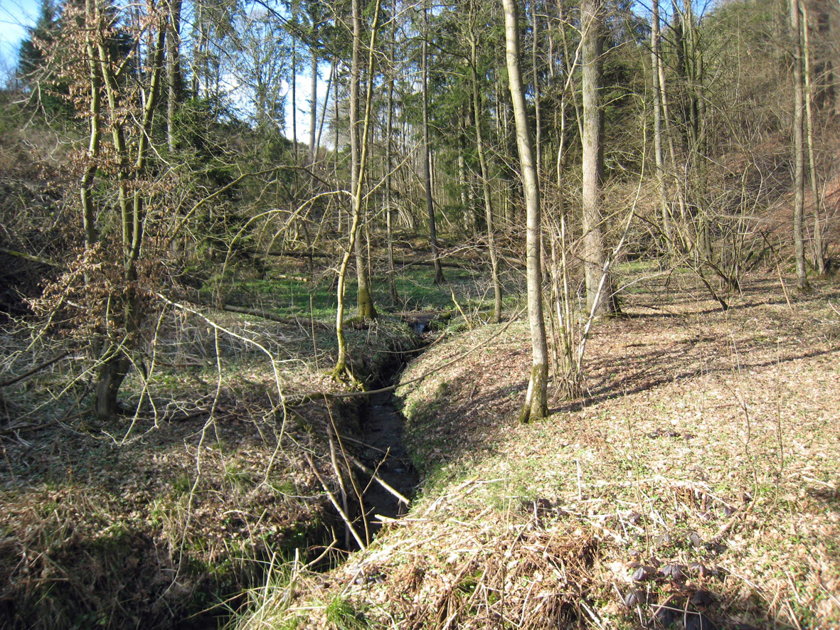
A small, narrow creek winds through a deciduous forest with bare ground and scattered leaves under a canopy of trees in early spring.
The Oelsiefen creek flowing through a deciduous forest in the Ölsiefental nature reserve.

Naturschutzgebiet Ölsiefental history and protected-area timeline

The Naturschutzgebiet Ölsiefental was established in 1990 under the landscape plan covering the municipality of Kürten. Its designation came as part of a broader effort in the Rheinisch-Bergischer Kreis to formally protect small stream valleys, spring areas, and their associated deciduous woodlands as dedicated nature reserves, recognizing their ecological value in a predominantly agricultural and forested rural landscape.

The selection of the Ölsiefen valley reflected long-standing concerns about the conservation of near-natural stream courses and their surrounding forests in the area. By setting aside both the valley floor habitats and the slope forests, the designation aimed to preserve an interconnected system rather than isolated fragments. Management responsibility was given to the Untere Landschaftsbehörde of the Rheinisch-Bergischer Kreis, which continues to oversee the reserve within the framework of the community-level landscape plan for Kürten, with the reserve area documented under the official code GL-021.

Naturschutzgebiet Ölsiefental landscape and geographic character

The landscape of the Naturschutzgebiet Ölsiefental is shaped by a narrow, wooded stream valley typical of the western Bergisches Land. The protected area follows the Ölsiefen from its northern spring hollow down to its mouth at the Sülz river, producing a continuous topographical corridor of valley floor and slope. The valley is incised into gentle relief, with the stream threading between steep, sometimes shaded side slopes that carry the bulk of the woodland cover.

Where the Ölsiefen meets the Sülz, the valley opens slightly into a broader confluence area where the two watercourses interact. Upstream, the landscape narrows and becomes more enclosed, with the watercourse lined by wet woodland and flanked by cliffs of slope forest. The reserve's upper end, near the northern spring basin, contains mires and moist meadow fragments that reflect the way water emerges at the head of small valleys in this region. Throughout the protected stretch, the terrain alternates between moist valley bottoms, terraced slopes, and small foothill rises, giving the reserve a layered and varied relief within a very compact footprint.

Naturschutzgebiet Ölsiefental ecosystems, habitats, and plant life

Ecologically, the reserve is dominated by the interaction between flowing water, springs and deciduous forest. The stream corridor supports near-natural stretches of running water as well as spring-fed seepage zones, creating the moist conditions that allow brook, swamp and floodplain forest to develop along the valley floor. These wet forest types form the core of the area's habitat value, supplemented by small patches of sedge- and rush-rich wet grassland that indicate formerly open or extensively used valley bottomlands.

On the slopes, the woodland is a mixed deciduous forest in which different broadleaf species compete for light and moisture. Hornbeam, a tree traditionally associated with managed coppice woodland, is a notable element; in places the canopy includes older, overgrown coppice stands that give the forest a complex, multi-layered structure. This combination of springs, stream-side wet forest, wet grassland and structurally diverse slope woodland creates a habitat mosaic of high ecological interest, even though the overall area is small. The vegetation pattern is characteristic of the smaller stream valleys in the Bergisches Land, where moisture-loving woodland types persist in sheltered valleys while drier upland forests predominate elsewhere.

Naturschutzgebiet Ölsiefental wildlife and species highlights

Information about specific species in the reserve is limited in the source material, but the habitat mosaic strongly shapes what the area supports. The combination of wet woodland, springs, stream edge vegetation and structurally rich deciduous slope forest provides conditions for moisture-loving invertebrates, amphibians associated with clean, near-natural stream systems, and breeding or foraging habitat for woodland and waterside birds typical of the Bergisches Land.

The near-natural Ölsiefen stream itself, together with its spring areas, contributes to regional aquatic biodiversity by maintaining flowing water conditions and natural banks where fish, amphibian and invertebrate species associated with small forest streams can persist. The sedge- and rush-rich wet grassland patches and the open spring hollows add additional habitat types that can support specialized wetland flora and fauna. Although the reserve does not focus on charismatic large species, its ecological value lies precisely in supporting the less conspicuous but ecologically important communities that depend on intact stream valleys.

Naturschutzgebiet Ölsiefental conservation status and protection priorities

The reserve is classified as an IUCN Category IV Habitat/Species Management Area, reflecting that its primary function is not only to protect existing habitats but also to actively manage and develop them. The official protection goals focus on the conservation and safeguarding of several legally protected biotopes: brook, swamp and floodplain forests; sedge- and rush-rich wet meadows; spring areas; and natural or near-natural sections of standing and flowing inland waters.

A second explicit goal is the conservation and development of the species-rich, structurally diverse near-natural slope deciduous mixed forest, including older coppice-derived stands rich in hornbeam. These goals go beyond static preservation, acknowledging that former land uses such as grazing, coppicing and mowing have shaped woodland structure and that targeted development is needed to maintain or restore habitat quality. Within the regional framework of the Rheinisch-Bergischer Kreis, the Ölsiefental contributes to the broader network of small valley and forest reserves that maintain ecological connectivity across the rural landscape of the Bergisches Land.

Naturschutzgebiet Ölsiefental cultural meaning and human context

The reserve sits within a rural landscape that has long been shaped by small-scale forestry, grazing and stream-valley agriculture. The presence of overgrown coppice woodland rich in hornbeam reflects the historical practice of managing slopes as Niederwald, or coppice forest, in which trees were periodically cut back to produce small wood. The wet grassland fragments and the impoundment-like character of parts of the valley also echo former pastoral and meadow use of valley floors.

Local villages such as Engeldorf and Offermannsheide, mentioned in the geographical description of the reserve, are part of the dispersed settlement pattern of the Bergisches Land, where small hamlets historically clustered along stream valleys. The reserve thus represents not only a natural area but also a piece of a working cultural landscape in which the boundaries between managed woodland, traditional meadowland and natural stream courses remain legible in the vegetation pattern.

Top sights and standout views in Naturschutzgebiet Ölsiefental

Among the reserve's strongest features is the complete small catchment it preserves: a stream that begins in named spring hollows, flows through near-natural wet forest, and meets the larger Sülz river at a clearly defined confluence. The protected area is essentially a self-contained ecological system within a few hectares.

Its mixed deciduous slope forest with older, hornbeam-rich coppice stands, its legally protected wet biotopes including brook, swamp and floodplain forest, and its surviving sedge- and rush-rich wet grassland give the site a habitat diversity that is unusual for a reserve of its size. The combination of spring, stream, wet woodland and dry slope forest within a single continuous valley is the reserve's defining conservation asset.

Best time to visit Naturschutzgebiet Ölsiefental

Spring and early summer are generally the most rewarding periods to experience a reserve of this type, when the deciduous canopy is still opening and the understory, wet meadow plants and stream-side vegetation are most visible. Warmer and drier months draw attention to the woodland structure, the contrast between wet valley floor and drier slope, and the cool, shaded character of the brook forest along the Ölsiefen.

Late autumn reveals the broader topography of the valley more clearly, after foliage has thinned, and is well suited to appreciating the relationship between the protected stream course and the surrounding agricultural and forest landscape of Kürten. Quiet, low-light periods also tend to be best for observing woodland and waterside wildlife typical of small Bergisches Land valleys.

Monthly climate preview

Long-term representative point measurements of monthly temperature and precipitation patterns

Naturschutzgebiet Ölsiefental Climate Normals and Annual Temperature Rhythm

Representative point measurements for Naturschutzgebiet Ölsiefental outline a measured annual temperature range from near freezing winter minimums to warm summer maximums alongside steady daily precipitation rates. Examining the full twelve-month profile provides deeper context for monthly climate variations across the protected terrain.
Annual mean9 °C
0 °C18 °C
Jan
Feb
Mar
Apr
May13°
Jun16°
Jul18°
Aug18°
Sep14°
Oct
Nov
Dec
Warmest month
July

18.3 °C

Coolest month
January

0.3 °C

Wettest month
December

3 mm/day

Driest month
April

1.8 mm/day

Park location guide

Geography guide, regional context, and park location map for Naturschutzgebiet Ölsiefental

Naturschutzgebiet Ölsiefental park geography, regions, and map view in Germany

Understand where Naturschutzgebiet Ölsiefental sits in Germany through a broader geographic reading of the surrounding landscape, nearby location context, and its mapped position within the national park landscape.

How Naturschutzgebiet Ölsiefental fits into Germany

Germany is a federal republic in Western and Central Europe with a population of over 83 million across sixteen constituent states. It is Europe's largest economy by nominal GDP and a major global exporter and importer. The capital is Berlin, and the country borders Denmark, Poland, Czech Republic, Austria, Switzerland, France, Luxembourg, Belgium, and the Netherlands.

Wider geography shaping Naturschutzgebiet Ölsiefental in Germany

Germany is located in Western and Central Europe, spanning 357,022 km². It borders Denmark to the north, Poland and the Czech Republic to the east, Austria and Switzerland to the south, and France, Luxembourg, Belgium, and the Netherlands to the west. The country has coastlines on the Baltic Sea and North Sea to the north, with the Alps located in the southern region.

Map view of Naturschutzgebiet Ölsiefental

Use this park location map to pinpoint Naturschutzgebiet Ölsiefental in Germany, understand its exact geographic position, and read its mapped placement within the surrounding landscape more clearly.

Pigeon | © OpenStreetMap contributors

Location context for Naturschutzgebiet Ölsiefental

North Rhine-Westphalia

Explore visual records of the stream, wet woodland habitats, and protected topography.

Naturschutzgebiet Ölsiefental Photos, Landscape Scenery, and Protected Valley Views

Visual documentation captures the natural topography of Naturschutzgebiet Ölsiefental, including the wooded stream valley, spring headwaters, and wet grassland habitats. Photographic collections illustrate the protected landscape character of the Bergisches Land stream reserve.

A small, narrow creek winds through a deciduous forest with bare ground and scattered leaves under a canopy of trees in early spring.

Park atlas

Compare adjacent valley ecosystems and regional nature reserves across the Bergisches Land

Explore Other Parks and Protected Areas Near Naturschutzgebiet Ölsiefental

Visitors can browse nearby protected landscapes and stream valley reserves that share similar woodland and wetland habitats. Expanding the search helps reveal the broader network of conserved natural areas throughout the surrounding region.
A horizontal watercolor painting depicting a soft landscape with distant rolling hills, mid-ground green forests, and a foreground area of wetland and water.
Nature reserveNordrhein-Westfalen
About 1 km away#1 closest

West

Naturschutzgebiet Alemigsiefental: Nature Reserve Geography and Protected Valley Landscapes

Protected riparian habitat in the Bergisches Land of Germany

Examine the mapped boundaries and natural terrain of Naturschutzgebiet Alemigsiefental. This nature reserve in Nordrhein-Westfalen protects an essential stream corridor, wet meadows, and floodplain forests, serving as a critical habitat within the regional network of protected watercourses.

Area
0.101 km²
Established
1990
IUCN
IV
Relief
Upland
Nature reserveRheinisch-Bergischer Kreis
About 3.9 km away#2 closest

Northeast

Naturschutzgebiet Olpebachtal: Nature Reserve and Protected Stream Valley Geography

A protected landscape mosaic in Rheinisch-Bergischer Kreis

Naturschutzgebiet Olpebachtal protects a unique, near-natural section of the Olpebach stream valley. Characterized by wide floodplains, wet meadows, and narrow tributary ravines, the reserve functions as a critical habitat linkage within the rolling terrain of the Bergische Hochflächen. Its geography provides a clear window into the stream-floodplain systems that define the natural character of the broader region.

Area
0.251 km²
Established
1990
IUCN
IV
Nature reserveNordrhein-Westfalen
About 6.1 km away#3 closest

Northwest

Naturschutzgebiet Scherfbachtal: Protected Stream Valley and Spring Landscape Analysis

Regional protected geography in Nordrhein-Westfalen

Delve into the protected terrain of Naturschutzgebiet Scherfbachtal, which preserves a rare network of spring basins, wet meadows, and floodplain forests. This site exemplifies the ecological value of small, interconnected valley habitats within the wider Bergisches Land region of North Rhine-Westphalia, providing essential sanctuary for local stream-dependent ecosystems.

Established
2012
IUCN
IV
A soft watercolor painting of a pastoral landscape featuring a stream flowing through green meadows and gentle hills under a pale sky.
Nature reserveRheinisch-Bergischer Kreis
About 8 km away#4 closest

Northwest

Naturschutzgebiet Scherfbachtal (Odenthal) Protected Area and Stream Valley Map

A preserved riparian landscape in Rheinisch-Bergischer Kreis.

Naturschutzgebiet Scherfbachtal (Odenthal) represents a well-preserved nature reserve spanning five sections of the Scherfbach stream corridor. The area encompasses diverse ecosystems including near-natural meandering brooks, floodplain forests, and steep Siefen side valleys. This protected landscape is defined by its high habitat connectivity, providing a vital network of springs, marshy meadows, and mature woodlands within the Bergisches Land geography.

Area
1.053 km²
Established
1994
IUCN
IV
A soft watercolor illustration of a landscape with green forest tree lines in the foreground, wetland grasses, and pale rolling hills in the background against a white sky.
Nature reserveNordrhein-Westfalen
About 8.6 km away#5 closest

Southeast

Naturschutzgebiet Schlingenbachtal: Protected Stream Valley and Floodplain Geography

A vital riparian habitat reserve in Nordrhein-Westfalen, Germany

Naturschutzgebiet Schlingenbachtal protects a nearly complete stream-valley ecosystem, featuring an intricate network of wet meadows, alder carr, and forested slopes. By preserving the natural course of the Schlingenbach, the reserve functions as an essential node within regional habitat networks, offering a distinct study in riparian geography and forest land management.

Area
0.689 km²
Established
1988
IUCN
IV
A horizontal watercolor painting showing a peaceful river valley with green meadows, trees on both sides, and soft rolling hills in the background under a warm sky.
Nature reserveRheinisch-Bergischer Kreis
About 10 km away#6 closest

Northwest

Naturschutzgebiet Pfengstbach: Protected Brook Valley and Meadow Landscape Analysis

Regional geography and natural valley terrain of Rheinisch-Bergischer Kreis

Analyze the structural integrity of the Naturschutzgebiet Pfengstbach brook valley, featuring a detailed look at its riparian woodland, seepage springs, and wet meadow distribution. This protected area offers a precise example of Bergisches Land valley morphology, where meadow floors and mixed deciduous slopes intersect within a significant Natura 2000-linked conservation corridor.

Area
18.6 km²
Established
1994
IUCN
IV
Relief
Upland
A horizontal watercolor illustration depicting rolling hills, forest patches, and a soft, hazy valley against a white background.
Nature reserveNorth Rhine-Westphalia
About 11 km away#7 closest

North

Mausbachtal Nature Reserve in North Rhine-Westphalia: Protected Stream Valley and Forest Landscapes

Regional stream valley network and deciduous forest landscape

This protected area in the Oberbergischer Kreis offers a window into the Bergische Hochflächen topography. The reserve highlights a mosaic of near-natural beech forest, wet meadows, and floodplain woodland, forming an integral link in the regional stream network connected to the Große Dhünn.

Area
0.237 km²
Established
2013
IUCN
IV
Watercolor painting of a rolling landscape with soft green hills, forest patches, and a winding stream.
Nature reserveGermany
About 11 km away#8 closest

Northeast

Schwarzenbachtal Nature Reserve: Regional Protected Landscape and Stream Valley Atlas

A mapped overview of protected habitats in North Rhine-Westphalia

Schwarzenbachtal serves as a vital protected area in Germany, defined by its elongated brook valley and intricate transitions between wet meadows and dry grassland mosaics. As part of the Bergisches Land stream network, this nature reserve illustrates the ecological significance of small-scale valley landscapes and their role in regional conservation geography.

Area
0.082 km²
Established
2013
Relief
Upland
Climate
Temperate

Common questions about visiting, size, designation, and location context for Naturschutzgebiet Ölsiefental

Naturschutzgebiet Ölsiefental FAQs for park facts, access, geography, and protected area context

Find quick answers about Naturschutzgebiet Ölsiefental, including protected-area facts, park geography, trail and visitor context, and how the park fits into its surrounding country and regional landscape.
MoriAtlas Explorer

Continue Your Protected Areas Search Across the Global Atlas

Deepen your exploration by continuing the structured search for national parks and protected areas worldwide. Utilize the comprehensive filtering capabilities to compare different conservation landscapes and refine your understanding of global park geography. Discover more about the distribution and characteristics of protected natural areas.

Global natural geography