
Mori Atlas logo
Nature reserveNaturschutzgebiet Plästerlegge – Auf’m Kipp

Discover the unique geography of this waterfall-fed ravine forest and mountain peatland mosaic

Naturschutzgebiet Plästerlegge – Auf’m Kipp: A Protected Gorge and Moorland Landscape in Hochsauerlandkreis

(Naturschutzgebiet Plästerlegge – Auf'm Kipp)

The Naturschutzgebiet Plästerlegge – Auf’m Kipp nature reserve features a dramatic 20-metre waterfall carving through Middle Devonian slate. This protected area in the Hochsauerlandkreis region of western Germany hosts a rare ecosystem transition from deep, humid ravine forests to upland saddle moors. Mapped boundaries showcase a distinctive landscape mosaic of ancient broadleaf woods, rocky cliffs, and bog birch habitats.

ravine forestgorgewaterfallslate cliffshigh moorraised bog
An artistic vector illustration showing a waterfall flowing down a rocky canyon wall into a stream, surrounded by coniferous and deciduous trees under a sunny sky.

Naturschutzgebiet Plästerlegge – Auf’m Kipp

Nature reserve

Park overview

Structured park overview, official facts, and landscape profile for Plästerlegge, Auf'm Kipp Nature Reserve

Plästerlegge, Auf'm Kipp Nature Reserve park facts, protected area profile, and essential visitor context

Review the core facts for Plästerlegge, Auf'm Kipp Nature Reserve, including designation, size, terrain, visitor scale, habitats, and operating context in one park-focused overview.

About Plästerlegge, Auf'm Kipp Nature Reserve

Plästerlegge – Auf'm Kipp is a compact but ecologically rich nature reserve that captures two very different landscapes in a single protected area. The lower, central piece of the reserve follows a steep, rocky gorge cut by the Plästerlegge stream into Middle Devonian slate rock. A waterfall approximately 20 metres high marks the dramatic core of the site, while above the cascade the valley walls rise sharply, forming shaded, moisture-laden air pockets that remain cool even in summer.

The upper, eastern part of the reserve climbs toward the summit ridge of the Auf'm Kipp hill, where a different ecology takes over. Outside the reserve but closely linked to it is a high rock band, while within the protected boundary sits a small, basin-shaped high moor. The moor holds a mosaic of rushes, purple moor grass, birch bog woodland, and spruce moor woodland, with cotton grasses, crowberry, and other bog specialists occurring in the wetter sections.

Forested slopes make up most of the area, and the woodland here is unusually old and structurally diverse. Many trees exceed 165 years of age, and the canopy is dominated by European beech with a substantial share of valuable hardwoods such as sycamore maple and wych elm, plus pedunculate oak and hornbeam. The gorge specifically qualifies as a classic 'silverleaf ravine forest' (Schluchtwald), thanks to extensive populations of Lunaria rediviva, a species otherwise rare in North Rhine-Westphalia.

The reserve lies east of the small village of Wasserfall (part of Bestwig) and is crossed by long-distance footpaths, including the Sauerland hiking routes X10 and X16, the Bestwig panorama trail, and the Bergmannsweg mining-themed route. Management measures focus on rewilding upper slopes, replacing water-demanding spruce with beech and other broadleaves, and reducing agricultural pressure in spring catchment areas to improve both water quantity and quality feeding the waterfall.

Quick facts and research context for Plästerlegge, Auf'm Kipp Nature Reserve

Plästerlegge – Auf'm Kipp is a protected nature reserve of about 28.5 hectares, split between the municipality of Bestwig (around 13.8 ha) and the town of Olsberg (14.7 ha) in the Hochsauerland district. It combines a steep slate gorge and waterfall with a small high moor on the slope of the Auf'm Kipp hill. The reserve forms part of the larger FFH (Flora-Fauna-Habitat) area 'Schluchtwälder bei Elpe', covering priority habitat types of ravine mixed forest and restorable raised bog. Protection history dates back to a first designation in 1952, with the current combined designation established through landscape plans adopted by the Hochsauerlandkreis in 2004 and 2007.

Protection and recognition

Documented terrestrial protection scope and historical designation records

Protection Status and Designation History for Naturschutzgebiet Plästerlegge – Auf’m Kipp

Naturschutzgebiet Plästerlegge – Auf’m Kipp holds a documented terrestrial protection status established in two thousand and four. Official designation history and management scope details provide structured context for this protected natural area.

Protection details

Protection scope
Terrestrial
Designated year
2004
Transboundary protection
No
Park context

Deeper park guide and search-rich context for Plästerlegge, Auf'm Kipp Nature Reserve

Plästerlegge, Auf'm Kipp Nature Reserve history, landscape, wildlife, and travel context

Explore Plästerlegge, Auf'm Kipp Nature Reserve through its history, landscape character, ecosystems, wildlife, conservation priorities, cultural context, and seasonal travel timing in a structured park guide built for atlas discovery and search intent.

Why Plästerlegge, Auf'm Kipp Nature Reserve stands out

Plästerlegge, Auf'm Kipp is best known for the Plästerlegge waterfall, a roughly twenty-metre cascade set in a cool, humid slate gorge that supports one of North Rhine-Westphalia's most distinctive ravine forests. A large population of the large-flowered silverleaf (Lunaria rediviva) grows in the gorge, which is uncommon at this scale in the region and gives the forest its rare 'silverleaf ravine forest' character. The reserve is also recognised for its contrasting ecology: above the gorge, a small saddle high moor adds a peatland dimension that is unusual within an otherwise rocky, forested valley system. The combination of slate cliffs, damp spray zones, ancient beech-ash-elm forest, and intact bog fragments makes the area a key reference site for protected gorge-and-bog mosaics in the Sauerland.
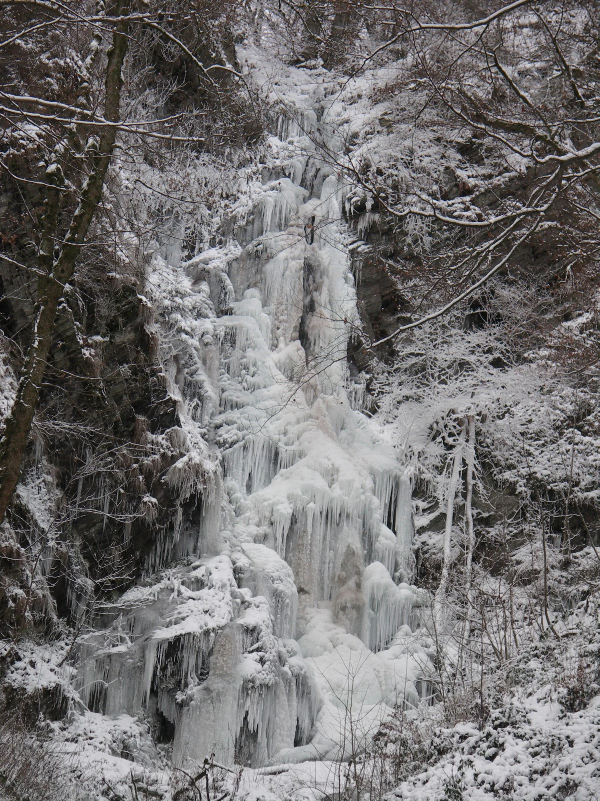
A vertical view of the Plästerlegge waterfall frozen into large ice formations, surrounded by a snow-covered ravine forest.
The Plästerlegge waterfall completely frozen during winter.

Plästerlegge, Auf'm Kipp Nature Reserve history and protected-area timeline

The protection history of Plästerlegge extends back to the early post-war period. The Wasserfall area was first designated as a nature reserve by the Arnsberg district government on 29 July 1952, covering about 11.7 hectares in the then-municipality of Ramsbeck. The original ordinance was renewed on 23 January 1968, again by the district government of Arnsberg.

In 1975, the municipal restructuring in North Rhine-Westphalia transferred the reserve, now catalogued as NSG HSK-452, to the enlarged municipality of Bestwig. The Plästerlegge reserve continued in its original form until the early 2000s, when the Hochsauerlandkreis began reviewing its landscape plans.

On 16 December 2004, the district council of the Hochsauerlandkreis adopted the new landscape plan for Olsberg, formally designating a new 'Plästerlegge – Auf'm Kipp' nature reserve (NSG HSK-260) of about 14.7 hectares on Olsberg municipal territory. This linked the waterfall and gorge to the moor and slopes of the Auf'm Kipp hill, and integrated the reserve into the larger FFH site 'Schluchtwälder bei Elpe' under the EU Habitats Directive.

A second extension followed on 14 December 2007, when the district council adopted the Bestwig landscape plan and added a further 13.78 hectares on Bestwig territory to the same combined reserve. At this stage the original Plästerlegge reserve was enlarged from 11.7 to 13.78 hectares. The two new sub-areas together give the present-day reserve its hybrid character: a small, mosaic nature reserve spanning two municipalities but unified by stream, slope, and rock.

Plästerlegge, Auf'm Kipp Nature Reserve landscape and geographic character

The landscape of Plästerlegge – Auf'm Kipp is dominated by a narrow, steep-sided gorge that drops sharply from the slopes of the Auf'm Kipp ridge down to the valley floor near the village of Wasserfall. The stream leaps roughly 20 metres in a single cascade through the gorge, creating a turbulent spray zone at the foot of the fall.

The gorge walls are formed of Middle Devonian slate, which has weathered into jagged rock bands and a high cliff face along the Auf'm Kipp ridge (outside the protected boundary itself). Deep, narrow side valleys known locally as 'Siepen' cut back into the slopes, adding further relief and shelter to the terrain.

Above the gorge, the land opens into a rougher upland slope with a small basin-shaped high moor near the watershed. The moor lies in a relatively gentle saddle position between higher ground, with boggy outflow channels descending back into the forested slopes. The combination of sharp gorge, broadleaf forest, rocky cliff faces, and an elevated peat basin gives the reserve a strongly three-dimensional character over a small area.
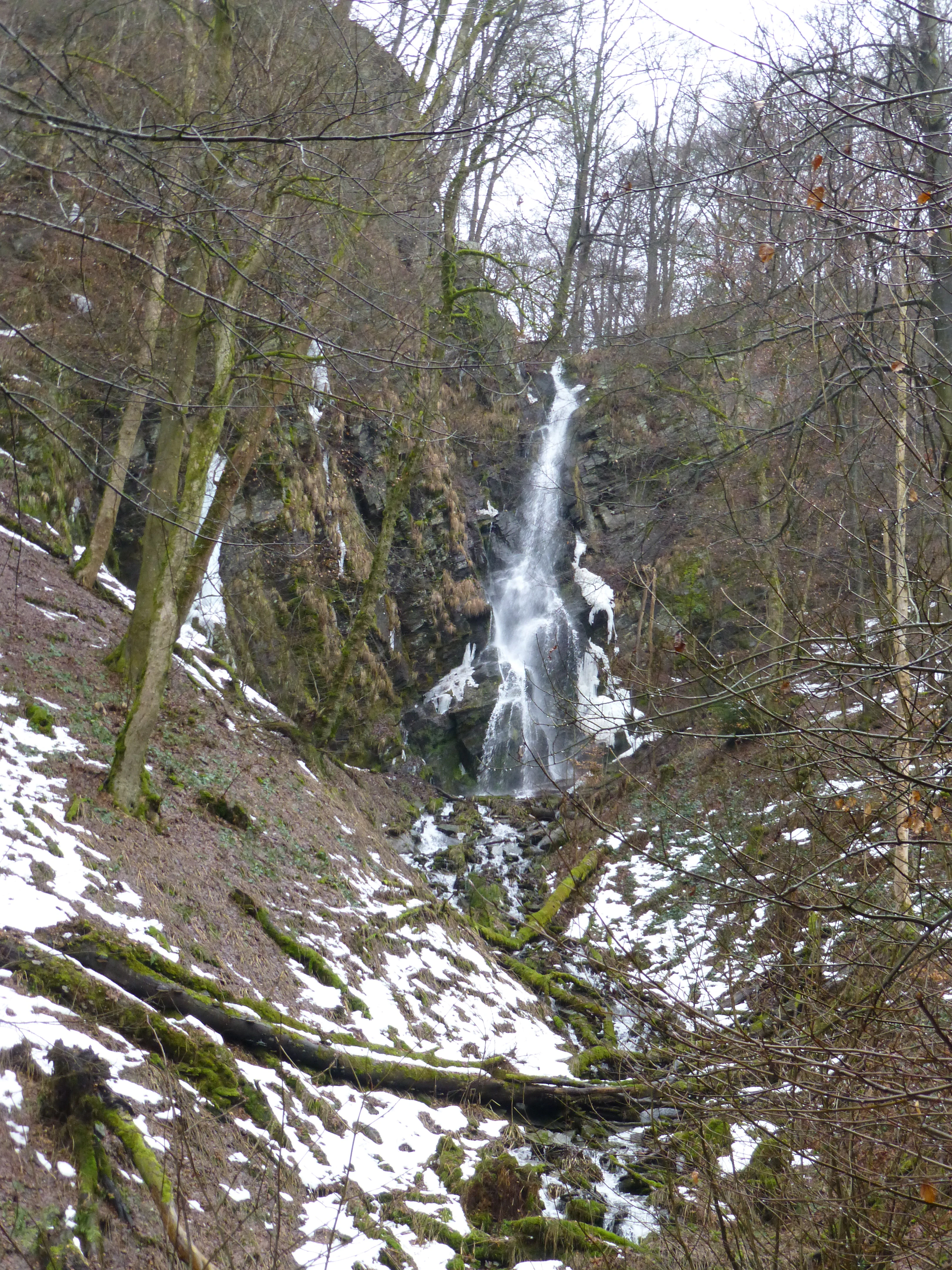
A narrow, cascading waterfall flowing down a rocky, forested ravine, with patches of snow on the ground and leafless trees.
The Plästerlegge waterfall flowing during winter conditions.

Plästerlegge, Auf'm Kipp Nature Reserve ecosystems, habitats, and plant life

Ecologically, Plästerlegge – Auf'm Kipp is essentially a protected mosaic of two priority habitats: ravine and slope mixed forest (FFH habitat type 9180) and degraded, but still restorable, raised bog (habitat type 7120). Both are listed as priority habitats under the European Habitats Directive.

The ravine forest is the most prominent feature and is unusually well developed. The canopy is a patchwork of European beech, sycamore maple, wych elm, pedunculate oak, and hornbeam, with many individual trees older than 165 years. The floor and lower slopes of the gorge are dominated by Lunaria rediviva (large-flowered silverleaf), giving the site its special 'silverleaf ravine forest' status. Splashes, seepage, and cool humid air along the waterfall create conditions in which rare ferns, mosses, and lichens typical of the Mauerraute fern association survive.

The high moor component is smaller, but ecologically significant. The raised bog contains a classic mosaic of rushes and purple moor grass, with bog birch woodland and spruce moor woodland developing along the wetter outflow edges. Rewetting is a key management goal, alongside converting surrounding spruce plantations to broadleaf forest, particularly beech, to improve water retention feeding the waterfall.
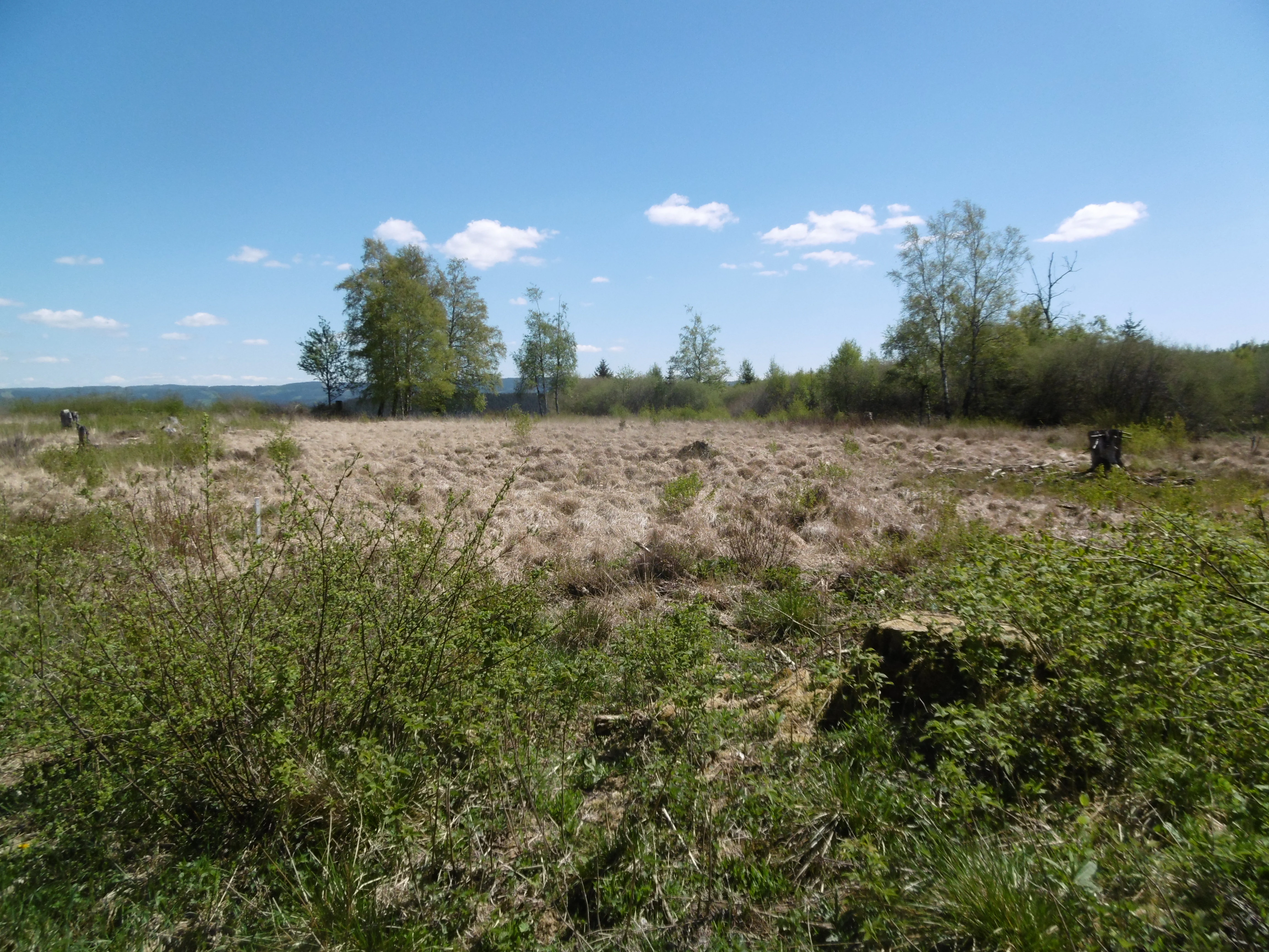
A wide, open moorland area with tan-colored grasses, surrounded by scattered deciduous trees under a clear blue sky.
The moorland landscape within the Naturschutzgebiet Plästerlegge, Auf’m Kipp nature reserve.

Plästerlegge, Auf'm Kipp Nature Reserve wildlife and species highlights

The reserve is most strongly characterized by its plant communities rather than its large mammals, but it supports notable bird life typical of mature, mixed upland forests. Confirmed breeding species in and around the reserve include the wood warbler, the grey wagtail (especially along the waterfall and stream), the blackcap, and the common whitethroat in warmer scrubby edges near the village.

The combination of mature broadleaf trees, deep gorge microclimate, and bog margins provides nesting and feeding habitat for several woodland and edge species typical of the Sauerland. While the published record focuses on breeding birds, the continuity of older forest, deadwood-rich slopes, and connected FFH woodland also supports typical woodland invertebrates, small mammals, and bats associated with the broader Schluchtwälder bei Elpe site.

Plästerlegge, Auf'm Kipp Nature Reserve conservation status and protection priorities

Plästerlegge – Auf'm Kipp holds conservation significance at three nested levels: as a small-scale nature reserve under North Rhine-Westphalian law, as a part of the regional protected-area network in the Hochsauerlandkreis, and as a contributor to the EU Natura 2000 network through the FFH site 'Schluchtwälder bei Elpe'.

Its particular importance lies in representing habitat type 9180 (ravine and slope mixed forests) and habitat type 7120 (degraded still-restorable raised bogs), both of which are priority habitats under the Habitats Directive. The gorge forest is notable for its silverleaf populations, its old-growth tree age structure, and its relict glacial flora surviving in the spray-zone cliff microhabitats, giving the site strong botanical value beyond the regional scale.

Active management targets include restoring natural hydrology in both the bog and the waterfall's catchment, replacing spruce with broadleaf forest to reduce water loss through transpiration, reducing agricultural intensity around springs, and preventing illegal ice climbing in winter that disturbs frozen waterfall habitat. Together with neighbouring reserves on the Auf'm Riese and Steinmarkskopf-Hardenberg, Plästerlegge forms a network of protected gorge and slope forest along the upper Sauerland valleys.

Plästerlegge, Auf'm Kipp Nature Reserve cultural meaning and human context

Plästerlegge – Auf'm Kipp sits within a region shaped by centuries of small-scale farming, slate mining, and forestry. The nearby village of Wasserfall itself takes its name from the cascade, reflecting how the waterfall has long been a local landmark. The wider Bestwig and Olsberg area belong to the historic Sauerland, whose economy and identity have long been tied to waterpower, slate quarrying, smelting, and walkable mountain scenery.

The hiking routes crossing the reserve, including the Sauerland long-distance trails (X10 and X16), the Bestwig panorama trail, and the Bergmannsweg mining route, link the gorge to a broader regional tradition of cultural and industrial hiking tourism. The reserve is also a focus for environmental education in the Hochsauerlandkreis, illustrating how steep gorge forests, peat bogs, and old mining landscapes coexist in a single small valley system.

Top sights and standout views in Plästerlegge, Auf'm Kipp Nature Reserve

The most striking highlight of Plästerlegge – Auf'm Kipp is the 20-metre waterfall in a narrow slate gorge, framed by ancient beech-maple-elm forest and dense silverleaf undergrowth. Equally distinctive is the unusual pairing of this cool ravine ecosystem with a small high moor on the slopes of the Auf'm Kipp hill, complete with bog birch woodland and a cotton-grass-rich peatland mosaic.

The reserve also stands out for its relict glacial flora on the waterfalls's rocky cliffs, its age-structured mixed broadleaf forest, and its role in the EU Habitats Directive site 'Schluchtwälder bei Elpe', one of the few Sauerland FFH sites explicitly anchored to a single, iconic waterfall. Active rewilding, hydrological restoration, and former spruce conversion to beech give the reserve a strong restoration dimension alongside its protected natural features.
Monthly climate preview

Long-term representative point measurements for temperature and precipitation rhythm

Naturschutzgebiet Plästerlegge – Auf’m Kipp Climate Normals and Annual Weather Patterns

Representative coordinates record an annual thermal progression spanning subzero winter minimums and warm summer maximums alongside steady daily precipitation rates. Analyzing these recorded long-term averages helps trace environmental baseline conditions across the protected landscape.
Annual mean9 °C
0 °C18 °C
Jan
Feb
Mar
Apr
May12°
Jun16°
Jul18°
Aug18°
Sep14°
Oct
Nov
Dec
Warmest month
July

18.2 °C

Coolest month
January

0.3 °C

Wettest month
December

2.7 mm/day

Driest month
April

1.7 mm/day

Park location guide

Geography guide, regional context, and park location map for Plästerlegge, Auf'm Kipp Nature Reserve

Plästerlegge, Auf'm Kipp Nature Reserve park geography, regions, and map view in Germany

Understand where Plästerlegge, Auf'm Kipp Nature Reserve sits in Germany through a broader geographic reading of the surrounding landscape, nearby location context, and its mapped position within the national park landscape.

How Plästerlegge, Auf'm Kipp Nature Reserve fits into Germany

Germany is a federal republic in Western and Central Europe with a population of over 83 million across sixteen constituent states. It is Europe's largest economy by nominal GDP and a major global exporter and importer. The capital is Berlin, and the country borders Denmark, Poland, Czech Republic, Austria, Switzerland, France, Luxembourg, Belgium, and the Netherlands.

Wider geography shaping Plästerlegge, Auf'm Kipp Nature Reserve in Germany

Germany is located in Western and Central Europe, spanning 357,022 km². It borders Denmark to the north, Poland and the Czech Republic to the east, Austria and Switzerland to the south, and France, Luxembourg, Belgium, and the Netherlands to the west. The country has coastlines on the Baltic Sea and North Sea to the north, with the Alps located in the southern region.

Map view of Plästerlegge, Auf'm Kipp Nature Reserve

Use this park location map to pinpoint Plästerlegge, Auf'm Kipp Nature Reserve in Germany, understand its exact geographic position, and read its mapped placement within the surrounding landscape more clearly.

Pigeon | © OpenStreetMap contributors

Location context for Plästerlegge, Auf'm Kipp Nature Reserve

Hochsauerlandkreis

Visual reference for slate gorges, waterfalls, and protected habitats in Sauerland

Naturschutzgebiet Plästerlegge – Auf’m Kipp Photos and Landscape Scenery

Visual documentation captures the steep slate gorge, ancient ravine forests, and elevated high moor shaping the protected landscape of Naturschutzgebiet Plästerlegge – Auf’m Kipp. Field photography reveals the terrain, microclimates, and distinctive vegetation zones defining this Sauerland nature reserve.

A vertical view of the Plästerlegge waterfall frozen into large ice formations, surrounded by a snow-covered ravine forest.

A forest scene looking up a mossy, steep hillside with tall trees, with a narrow waterfall visible in the distance through the trunks.

A narrow, cascading waterfall flowing down a rocky, forested ravine, with patches of snow on the ground and leafless trees.

A wide, open moorland area with tan-colored grasses, surrounded by scattered deciduous trees under a clear blue sky.

Park atlas

Compare nearby regional valley reserves, gorge forests, and upland protected landscapes.

Parks Near Naturschutzgebiet Plästerlegge – Auf’m Kipp and Surrounding Protected Areas

Browsing other parks near Naturschutzgebiet Plästerlegge – Auf’m Kipp reveals wider regional patterns across nearby slate valleys and upland conservation networks. Comparing adjacent protected landscapes provides deeper context on local ravine forests, stream gorges, and high moor habitats.
A watercolor illustration depicting a serene river valley landscape with soft rolling hills and clusters of trees in the distance.
Nature reserveNordrhein-Westfalen
About 3.8 km away#1 closest

South

Naturschutzgebiet Oberes Elpetal: Protected Stream Valley and Floodplain Geography

A representative Sauerland nature reserve in Nordrhein-Westfalen.

This nature reserve protects a vital section of the upper Elpe stream, characterized by intact meanders, small-scale fish ponds, and moisture-loving vegetation. The valley floor creates a sheltered micro-habitat of riparian strips and traditional grazing lands, essential for the regional integrity of upland stream systems in the Hochsauerland district.

Area
0.112 km²
Established
2004
IUCN
IV
A watercolor painting of a serene landscape featuring rolling green hills in the distance, a line of trees in the middle ground, and a small winding stream in the foreground.
Protected landscapeHochsauerlandkreis
About 3.9 km away#2 closest

Northwest

Landschaftsschutzgebiet Bestwig: Mapped Protected Landscape in the Hochsauerland District

Geography, forest ridges, and historic mining terrain

Landschaftsschutzgebiet Bestwig covers significant portions of the central Sauerland, integrating forest crests and river valley slopes into a single protected area. The geography reveals a complex interaction between agricultural plantation land, unpopulated northern forest ridges, and historic mining remnants that define this distinct German landscape.

Area
49.12 km²
Established
2008
Relief
Mountain
Water
Minor water
Nature reserveNorth Rhine-Westphalia
About 5.6 km away#3 closest

East

Naturschutzgebiet Olsberger Ruhrtal oberhalb Assinghausen: Protected River Corridor and Valley Geography

Nature reserve featuring floodplain habitats in the Sauerland region

This nature reserve protects the natural flow and riparian ecosystem of the upper Ruhr river. Comprising three distinct sections, it serves as an important ecological link within the Sauerland landscape, preserving floodplain meadows and the river channel corridor. The area represents a focused approach to river-centered conservation in North Rhine-Westphalia, providing a clear example of protected habitat integration within the German landscape.

Area
0.155 km²
Established
2004
Relief
Lowland
Scope
Terrestrial
Nature reserveNordrhein-Westfalen
About 5.8 km away#4 closest

Southwest

Naturschutzgebiet Oegmannsholz: Protected Forest and Geological Landscapes in Nordrhein-Westfalen

A dense nature reserve featuring beech woodland, rock formations, and valley springs.

Naturschutzgebiet Oegmannsholz represents a concentrated protected area within the Sauerland region of Germany. This reserve safeguards diverse forest microhabitats, including mature beech stands and steep drainage lines known as Kerbtalsiepen. Its structural variety, from rocky outcrops to flowing springs, creates a distinct natural terrain within the broader North Rhine-Westphalia conservation network.

Area
0.113 km²
Established
2008
IUCN
IV
Nature reserveHochsauerlandkreis
About 5.8 km away#5 closest

Northwest

Naturschutzgebiet Ostenberg: Protected Nature Reserve and Cave System Geography

Upland forest terrain and karst geology in Hochsauerlandkreis

Naturschutzgebiet Ostenberg is a significant 21-hectare nature reserve that safeguards a complex of steep-slope forests and a multi-level limestone cave system. The site offers a detailed view into the karst processes and mature woodland ecology characteristic of the Sauerland region, providing a protected habitat for forest flora and wintering bat colonies.

Area
0.211 km²
Established
2008
Relief
Upland
Climate
Temperate
Nature reserveNordrhein-Westfalen
About 6.1 km away#6 closest

Southwest

Naturschutzgebiet Palmetal Protected Area Map and Sauerland Highland Landscape Context

Stream corridors and floodplain meadows in Nordrhein-Westfalen

Located in the foothills of the Rothaargebirge, Naturschutzgebiet Palmetal preserves a cohesive upland stream ecosystem. The reserve centers on the Palme and Brabecke brooks, protecting 11.7 hectares of wet meadow and gallery forest habitats. This site provides a representative look at the small-scale valley landscapes found within the Hochsauerlandkreis region, emphasizing the interplay between waterway, floodplain, and local terrain.

Area
0.117 km²
Established
2008
IUCN
IV
Relief
Upland
A watercolor illustration of a soft, rolling landscape with green hills, patches of trees, and grasses, set against a light background.
Nature reserveNorth Rhine-Westphalia
About 6.9 km away#7 closest

Northwest

Naturschutzgebiet Alert: Protected Juniper Heath and Rocky Landscapes of North Rhine-Westphalia

A rare cultural relic within the High Sauerland

Naturschutzgebiet Alert is a compact nature reserve protecting a surviving juniper heath and rocky ridge landscape near Meschede. The site offers a clear look at traditional grazing-dependent ecosystems, combining open grassland with scattered shrubs and woodland edges on a foundation of Devonian slate bedrock. It stands as a significant geographic remnant of the historical land-use patterns that once defined the wider High Sauerland region.

Area
0.021 km²
Established
1994
Relief
Upland
Scope
Terrestrial
Nature reserveNordrhein-Westfalen
About 7.7 km away#8 closest

North

Naturschutzgebiet Ochsenberg: Landscape and Geographic Profile of a German Nature Reserve

Examining forest reclamation on historic slate mine terrain

Located in the Hochsauerlandkreis, Naturschutzgebiet Ochsenberg serves as a case study in ecological succession. The reserve features an intricate mosaic of oak and beech woodland established over old spoil tips, while its abandoned mine tunnels remain essential for regional biodiversity as wintering habitats for protected bat species.

Area
0.124 km²
Established
2004
Relief
Upland
Scope
Terrestrial

Common questions about visiting, size, designation, and location context for Plästerlegge, Auf'm Kipp Nature Reserve

Plästerlegge, Auf'm Kipp Nature Reserve FAQs for park facts, access, geography, and protected area context

Find quick answers about Plästerlegge, Auf'm Kipp Nature Reserve, including protected-area facts, park geography, trail and visitor context, and how the park fits into its surrounding country and regional landscape.
MoriAtlas Explorer

Continue Your Protected Areas Search Across the Global Atlas

Deepen your exploration by continuing the structured search for national parks and protected areas worldwide. Utilize the comprehensive filtering capabilities to compare different conservation landscapes and refine your understanding of global park geography. Discover more about the distribution and characteristics of protected natural areas.

Global natural geography