
Mori Atlas logo
Nature reserveNaturschutzgebiet Schnettenberg

Examining the unique juniper heath ridge and forest transition zone in North Rhine-Westphalia

Naturschutzgebiet Schnettenberg Protected Nature Reserve: Geographic Map and Landscape Analysis

(Naturschutzgebiet Schnettenberg (HSK-009))

Naturschutzgebiet Schnettenberg preserves a rare, elongated juniper heath habitat situated on a southwest-facing ridge near the Kohlweder Bach valley in North Rhine-Westphalia. This nature reserve serves as a critical example of nutrient-poor grassland and dwarf-shrub vegetation, demonstrating the transition between open cultural landscapes and mature forest slopes. The site remains a significant historical relic of traditional land use patterns in the Sauerland region.

juniper heathWacholderheidedry grasslandMagergrünlanddwarf-shrub vegetationcultural landscape relic
A flat vector illustration of a valley between rocky mountains with a winding river in the center, framed by trees and yellow shrubs.

Naturschutzgebiet Schnettenberg

Nature reserve

Park overview

Structured park overview, official facts, and landscape profile for Naturschutzgebiet Schnettenberg

Naturschutzgebiet Schnettenberg park facts, protected area profile, and essential visitor context

Review the core facts for Naturschutzgebiet Schnettenberg, including designation, size, terrain, visitor scale, habitats, and operating context in one park-focused overview.

About Naturschutzgebiet Schnettenberg

Naturschutzgebiet Schnettenberg occupies a narrow, southwest-facing ridge in the Sauerland hill country, on the western edge of the historic hilltop town of Eversberg. Although the protected area is small, roughly 4.54 hectares and split into three sub-parcels, it represents a habitat type that has become vanishingly rare across western Germany. Its core feature is an old juniper heath (Wacholderheide), where dense, dark-green juniper bushes grow among nutrient-poor grassland and dwarf-shrub vegetation on shallow, often skeletal soils.

The reserve sits at a clear ecological interface. The gradually sloping ridge forms the transition between the sun-exposed open fields to the south and the steeper, forested valley flank of the Kohlweder Bach system to the north. This combination of dry, sunlit slopes and an adjacent wooded valley gives the site a striking gradient between open and closed habitats, which is one of the reasons it is considered regionally significant. The juniper shrubs themselves vary in density across the ridge: their number and size decrease from the southwest toward the northeast, where encroaching woody growth becomes more prominent.

Management is essential to the site's survival. One sub-area is already well advanced into woodland, while another is maintained as open ground through grazing, and a third through mowing. Sheep and goats are used together to keep the rough grassland open and to suppress the advance of shrubs and trees into the juniper heath. Without such intervention, succession would rapidly convert the ridge back into forest, eliminating exactly the dry, light-rich conditions that juniper bushes require.

Beyond its ecological value, the reserve preserves a tangible relic of historical land use in the Sauerland. The juniper heath is the product of long-standing traditional grazing practices combined with nutrient-poor soils on a ridge crest that was never suitable for ploughing. The site is more than 1,000 metres long, and its visibility from the surrounding landscape adds to its regional character. A section of an old track known as the 'ehemaliger Kriegerweg', much of it sunken like a hollow way, runs through the protected area and continues west toward the Warsteiner Kopf and across the district boundary into Kreis Soest, giving the reserve an additional layer of cultural landscape interest.

Quick facts and research context for Naturschutzgebiet Schnettenberg

Naturschutzgebiet Schnettenberg is located in the municipal area of Meschede, just west of the town of Eversberg, in the Hochsauerlandkreis district of North Rhine-Westphalia. The reserve was first designated in 1938, making it one of the oldest nature reserves in the Hochsauerlandkreis, and was redesignated and enlarged under the 2020 revision of the Meschede landscape plan.

The site covers roughly 4.54 hectares and is classified as an IUCN Category IV Habitat/Species Management Area. Its WDPA ID is 82543. The protected landscape consists of three sub-areas featuring juniper heath, nutrient-poor grassland, dwarf-shrub vegetation, and encroaching woodland, shaped by ongoing grazing and mowing management.

Protection and recognition

Explore documented protection status and official recognition records

Naturschutzgebiet Schnettenberg Protection Status and Protected Area Designation

Naturschutzgebiet Schnettenberg features verified protection status details and official registry records gathered from global conservation databases. Official management data and designation history provide clear context for evaluating regional conservation commitments.

Protection details

WDPA ID
82543
Park context

Deeper park guide and search-rich context for Naturschutzgebiet Schnettenberg

Naturschutzgebiet Schnettenberg history, landscape, wildlife, and travel context

Explore Naturschutzgebiet Schnettenberg through its history, landscape character, ecosystems, wildlife, conservation priorities, cultural context, and seasonal travel timing in a structured park guide built for atlas discovery and search intent.

Why Naturschutzgebiet Schnettenberg stands out

Naturschutzgebiet Schnettenberg is best known for preserving one of the very few surviving examples of a juniper heath (Wacholderheide) in the Sauerland region. The reserve maintains a cultural landscape relic in which old juniper bushes, nutrient-poor grassland, and dwarf-shrub vegetation coexist along a sloping ridge. It is also valued as a transitional habitat where open farmland meets a wooded valley slope. The reserve illustrates the broader conservation challenge of maintaining light-dependent juniper and dry grassland communities in a landscape where natural forest succession is steadily reclaiming open ground. Continuous grazing with sheep and goats is central to keeping this unusual habitat intact.
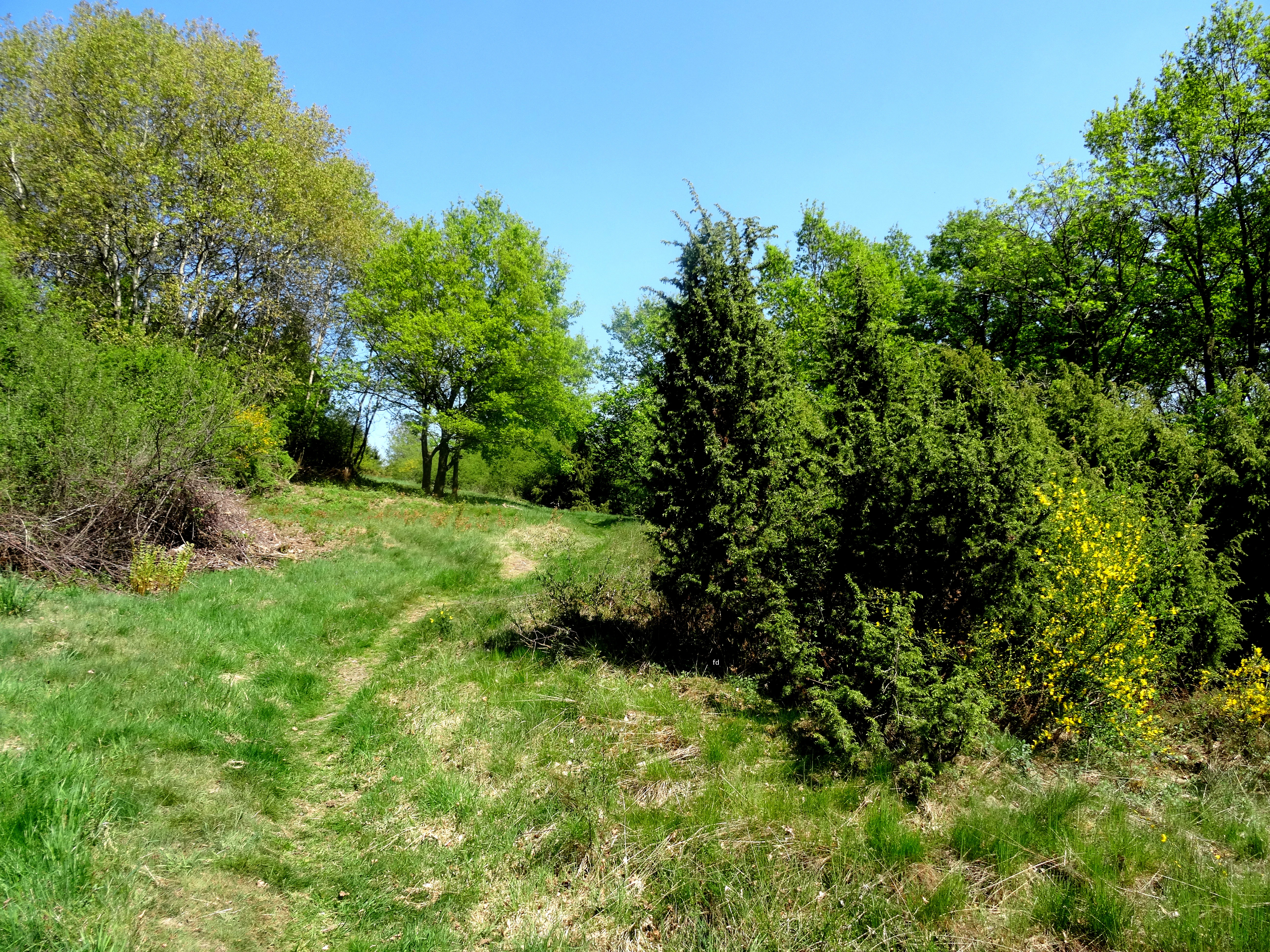
A sunny outdoor scene featuring green grass, small juniper trees, and taller deciduous trees under a clear blue sky in a nature reserve.
A view of the landscape at Naturschutzgebiet Schnettenberg, showcasing juniper shrubs and surrounding deciduous trees.

Naturschutzgebiet Schnettenberg history and protected-area timeline

Naturschutzgebiet Schnettenberg has a notably long protection history for a site of its size. It was first designated as a nature reserve in 1938, placing it among the very earliest nature reserves established in the Hochsauerlandkreis. The original designation covered a smaller area than today's reserve and reflected early twentieth-century recognition of the juniper heath as a habitat worthy of formal protection.

In 1994, the reserve was redesignated through the first Meschede landscape plan (Landschaftsplan Meschede), adopted by the district council (Kreistag) of the Hochsauerlandkreis, with an area of around three hectares. The landscape plan set out explicit conservation goals, focusing on the protection of the juniper heath and the suppression of woody succession, and laid the foundation for ongoing management through grazing and mowing.

When the Meschede landscape plan was later revised and reissued in 2020, the Schnettenberg reserve was redesignated once more and enlarged relative to its 1994 extent. The current protected area therefore combines decades of conservation attention with updated management prescriptions, including more intensive combined sheep and goat grazing and the planned relocation of an internal track to make continuous grazing enclosure easier.

Naturschutzgebiet Schnettenberg landscape and geographic character

The Schnettenberg reserve lies on a gradually descending southwest-facing ridge, or Grat, that drops from a higher hilltop area near Eversberg down toward the Kohlweder Bach valley. The topography creates a clear zonation: the more level, sun-exposed farmland on the upper slopes transitions into the steeper, wooded valley flank below. The reserve is stretched along this gradient rather than occupying a flat basin, which gives it an unusually elongated form of more than 1,000 metres in length.

Soils across the ridge are shallow and nutrient-poor, a key reason the juniper heath has survived here at all. These skeletal soils, combined with southern exposure, support a classic dry-grassland environment dotted with old juniper bushes and patches of dwarf-shrub vegetation, including heather-type species typical of low-nutrient ground. The character of the terrain shifts gradually along the ridge: open juniper-dominated heath in the southwest, increasingly shrubby and partially wooded conditions in the northeast.

The wooded Kohlweder Bach valley forms a dramatic backdrop, with denser tree cover, steeper slopes, and a noticeably cooler, more humid microclimate. The boundary between open ridge and forest is one of the most distinctive visual and ecological features of the site, and the reserve has been specifically valued for maintaining this contact zone between forest and open land.

Naturschutzgebiet Schnettenberg ecosystems, habitats, and plant life

Ecologically, Naturschutzgebiet Schnettenberg centers on the conservation of a juniper heath (Wacholderheide), a habitat type that today survives in only a handful of locations across the wider Sauerland and much of western Germany. Juniper heaths are relicts of centuries of traditional grazing on land that was never ploughed, and they depend on continuous management to prevent reversion to forest.

The vegetation of the reserve is a mosaic of several intergrading components. The most visible is the population of old common juniper bushes, which vary in size across the ridge and decline in abundance toward the northeast. Between and around the junipers grow mat-grass dominated nutrient-poor grassland (Magergrünland), interspersed with dwarf-shrub communities typical of acidic, low-nutrient soils. Some areas show significant colonization by tree saplings and shrubs, indicating active forest succession, particularly in the eastern parcel.

Management actions described in the local landscape plan aim to maintain the juniper heath in the long term by suppressing woody succession through targeted cutting and by ensuring sufficiently strong combined grazing pressure from sheep and goats. The plan explicitly recognises that restoring the Wacholderheide to its former condition requires significant intervention in already overgrown areas. The site is also valued as a transitional habitat where woodland and open countryside meet.

Naturschutzgebiet Schnettenberg wildlife and species highlights

The protected area is primarily valued for its habitat type rather than for individual charismatic species. The reserve supports the fauna typical of juniper heath and dry nutrient-poor grassland in central German uplands, with grazing pressure from sheep and goats helping to maintain open ground that benefits insects, ground-nesting birds, and other species associated with this kind of cultural landscape.

The grazing animals themselves are an important part of the site's ecological management. Sheep and goats used together produce a varied grazing pattern that suppresses competing woody plants more effectively than grazing by sheep alone. The mosaic of open heath, scattered shrubs, and adjacent forest edge also creates favourable conditions for a range of typical upland invertebrates and bird species that use both open and wooded habitats in close proximity.

Because the reserve is small and embedded within a broader agricultural and forested landscape, its wildlife value is closely tied to the continued openness of the heath and to the surrounding landscape mosaic rather than to any single flagship species.

Naturschutzgebiet Schnettenberg conservation status and protection priorities

Naturschutzgebiet Schnettenberg is protected primarily for its exceptional rarity value within the modern landscape. Juniper heaths of this kind constitute an extremely endangered habitat type, and the Schnettenberg heath is regarded as a highly worthy relic of historical land use that is regionally significant both for its length and for its function as a contact zone between forest and open land.

Conservation goals documented in the relevant landscape plan focus on three practical aims: protecting the existing juniper heath, optimising the current situation by reducing and controlling woody growth, and securing the site as a visible cultural landscape feature. Achieving these goals requires heavy intervention: substantial removal of successional woody growth in already overgrown parts of the reserve, and sufficiently intensive grazing across the whole area to keep the light-dependent junipers and associated dry-grassland and dwarf-shrub vegetation in good condition.

The reserve is also integrated into the broader network of protected areas in the Meschede area of the Hochsauerlandkreis, where numerous small nature reserves preserve fragments of heath, meadow, forest, and valley habitats. Within this network, Schnettenberg stands out as one of the earliest formally protected sites and as a key reference point for juniper-heath conservation in the district.

Naturschutzgebiet Schnettenberg cultural meaning and human context

The Schnettenberg reserve is fundamentally a cultural landscape relic. Its juniper heath is not a natural wilderness but the long-standing outcome of traditional grazing and low-intensity land use on ridge land that was unsuitable for cultivation. The presence of old, multi-stemmed juniper bushes testifies to centuries of continuous management that has now become rare.

An old track known as the 'ehemaliger Kriegerweg' crosses the reserve. Much of this route is hollow-way in character, worn deeply into the ground by historical traffic, and it continues west from the ridge past the Warsteiner Kopf into Kreis Soest. This historic route gives the reserve an additional cultural dimension, linking the ecological relic to older patterns of movement through the Sauerland uplands.

Top sights and standout views in Naturschutzgebiet Schnettenberg

Naturschutzgebiet Schnettenberg offers a rare chance to see an old juniper heath, mat-grass poor grassland, and dwarf-shrub vegetation preserved side by side along a length of more than 1,000 metres. The ridge setting gives an unusually clear view of how this habitat transitions into the forested Kohlweder Bach valley, and the reserve stands as one of the oldest formally protected nature reserves in the Hochsauerlandkreis.

Best time to visit Naturschutzgebiet Schnettenberg

As a juniper heath and dry grassland habitat, Schnettenberg is at its most visually distinctive in late spring and summer, when mat grasses and dwarf shrubs are in growth and grazing animals are active on the open parcels. Late spring also tends to offer the clearest contrast between the open, sunlit heath and the wooded valley flank. Because the reserve is small and managed primarily for ecological rather than visitor purposes, visits are best approached as quiet, low-impact walks along the surrounding rural landscape rather than as concentrated sightseeing trips.

Monthly climate preview

Long term temperature and precipitation records measured at representative park coordinates

Naturschutzgebiet Schnettenberg Climate Normals and Monthly Weather Statistics

Representative coordinates record measured monthly temperature and precipitation normals spanning from subzero winter minimums to warm summer maximums. Examining the complete twelve month climate profile reveals detailed seasonal variations across this protected area.
Annual mean9 °C
0 °C18 °C
Jan
Feb
Mar
Apr
May12°
Jun16°
Jul18°
Aug18°
Sep14°
Oct
Nov
Dec
Warmest month
July

18.2 °C

Coolest month
January

0.3 °C

Wettest month
December

2.7 mm/day

Driest month
April

1.7 mm/day

Park location guide

Geography guide, regional context, and park location map for Naturschutzgebiet Schnettenberg

Naturschutzgebiet Schnettenberg park geography, regions, and map view in Germany

Understand where Naturschutzgebiet Schnettenberg sits in Germany through a broader geographic reading of the surrounding landscape, nearby location context, and its mapped position within the national park landscape.

How Naturschutzgebiet Schnettenberg fits into Germany

Germany is a federal republic in Western and Central Europe with a population of over 83 million across sixteen constituent states. It is Europe's largest economy by nominal GDP and a major global exporter and importer. The capital is Berlin, and the country borders Denmark, Poland, Czech Republic, Austria, Switzerland, France, Luxembourg, Belgium, and the Netherlands.

Wider geography shaping Naturschutzgebiet Schnettenberg in Germany

Germany is located in Western and Central Europe, spanning 357,022 km². It borders Denmark to the north, Poland and the Czech Republic to the east, Austria and Switzerland to the south, and France, Luxembourg, Belgium, and the Netherlands to the west. The country has coastlines on the Baltic Sea and North Sea to the north, with the Alps located in the southern region.

Map view of Naturschutzgebiet Schnettenberg

Use this park location map to pinpoint Naturschutzgebiet Schnettenberg in Germany, understand its exact geographic position, and read its mapped placement within the surrounding landscape more clearly.

Pigeon | © OpenStreetMap contributors

Location context for Naturschutzgebiet Schnettenberg

North Rhine-Westphalia

Visual reference for rare juniper heath and sloping ridge terrain in the Sauerland region

Naturschutzgebiet Schnettenberg Photos and Landscape Scenery

Visual documentation captures the rare juniper heath and sloping dry grassland environments preserved along the Schnettenberg ridge. Protected area photography reveals the stark ecological transition where open ridge habitats meet the forested Kohlweder Bach valley below.

A sunny outdoor scene featuring green grass, small juniper trees, and taller deciduous trees under a clear blue sky in a nature reserve.

Park atlas

Compare adjacent ridge habitats and protected landscapes across the surrounding region

Parks Near Naturschutzgebiet Schnettenberg And Surrounding Regional Protected Areas

Browse other parks near Naturschutzgebiet Schnettenberg to examine similar dry grassland remnants, juniper heaths, and valley forest transitions. Regional protected areas offer valuable context for understanding local topography and habitat conservation across the Sauerland landscape.
Nature reserveNorth Rhine-Westphalia
About 4.4 km away#1 closest

Northeast

Naturschutzgebiet Oberes Lörmecketal: Protected Valley Landscapes in North Rhine-Westphalia

Swamp woodland and brook headwater geography

Delve into the landscape composition of Naturschutzgebiet Oberes Lörmecketal, a small yet ecologically significant nature reserve in the Sauerland. This record details the spring-fed valley terrain, alder-dominated wetlands, and the protected brook corridor that serves as a vital connecting point within the regional Natura 2000 network.

Area
0.03 km²
Established
1994
Relief
Upland
Climate
Temperate
A watercolor illustration of a soft, rolling landscape with green hills, patches of trees, and grasses, set against a light background.
Nature reserveNorth Rhine-Westphalia
About 4.9 km away#2 closest

Southeast

Naturschutzgebiet Alert: Protected Juniper Heath and Rocky Landscapes of North Rhine-Westphalia

A rare cultural relic within the High Sauerland

Naturschutzgebiet Alert is a compact nature reserve protecting a surviving juniper heath and rocky ridge landscape near Meschede. The site offers a clear look at traditional grazing-dependent ecosystems, combining open grassland with scattered shrubs and woodland edges on a foundation of Devonian slate bedrock. It stands as a significant geographic remnant of the historical land-use patterns that once defined the wider High Sauerland region.

Area
0.021 km²
Established
1994
Relief
Upland
Scope
Terrestrial
Nature reserveHochsauerlandkreis
About 6.1 km away#3 closest

East

Naturschutzgebiet Ostenberg: Protected Nature Reserve and Cave System Geography

Upland forest terrain and karst geology in Hochsauerlandkreis

Naturschutzgebiet Ostenberg is a significant 21-hectare nature reserve that safeguards a complex of steep-slope forests and a multi-level limestone cave system. The site offers a detailed view into the karst processes and mature woodland ecology characteristic of the Sauerland region, providing a protected habitat for forest flora and wintering bat colonies.

Area
0.211 km²
Established
2008
Relief
Upland
Climate
Temperate
Nature reserveHochsauerlandkreis
About 7.5 km away#4 closest

Southwest

Schürenbachtal Nature Reserve: Geographic Landscape and Protected Area Mapping

A meadow valley and stream corridor in the Hochsauerland district

Discover the geographic structure of the Schürenbachtal nature reserve, a 41-hectare protected area in the Hochsauerland district. This detailed overview highlights the stream's natural meanders, alder-lined banks, and the surrounding patchwork of meadows and copses that define this Sauerland highland ecosystem.

Area
0.414 km²
Established
2020
Water
Major water bodies
A watercolor painting of a serene landscape featuring rolling green hills in the distance, a line of trees in the middle ground, and a small winding stream in the foreground.
Protected landscapeHochsauerlandkreis
About 7.6 km away#5 closest

Southeast

Landschaftsschutzgebiet Bestwig: Mapped Protected Landscape in the Hochsauerland District

Geography, forest ridges, and historic mining terrain

Landschaftsschutzgebiet Bestwig covers significant portions of the central Sauerland, integrating forest crests and river valley slopes into a single protected area. The geography reveals a complex interaction between agricultural plantation land, unpopulated northern forest ridges, and historic mining remnants that define this distinct German landscape.

Area
49.12 km²
Established
2008
Relief
Mountain
Water
Minor water
Watercolor painting of soft rolling hills, grassy meadows, and distant mountain ridges in muted green and pink tones.
Nature reserveNorth Rhine-Westphalia
About 8.4 km away#6 closest

North

Naturschutzgebiet Piusberg: Protected Limestone and Calcareous Grassland Landscape in North Rhine-Westphalia

Mapping cliff habitats and dry grassland ecosystems in Warstein

Naturschutzgebiet Piusberg preserves a dense concentration of limestone geology and thermoophilic habitats across 8.3 hectares. This protected area in North Rhine-Westphalia showcases an instructive terrain gradient, ranging from steep northern rock faces to southern semi-dry meadows, serving as a vital ecological anchor for local biodiversity.

Area
0.083 km²
Established
2000
Relief
Upland
Scope
Terrestrial
Nature reserveNordrhein-Westfalen
About 9.2 km away#7 closest

East

Naturschutzgebiet Ochsenberg: Landscape and Geographic Profile of a German Nature Reserve

Examining forest reclamation on historic slate mine terrain

Located in the Hochsauerlandkreis, Naturschutzgebiet Ochsenberg serves as a case study in ecological succession. The reserve features an intricate mosaic of oak and beech woodland established over old spoil tips, while its abandoned mine tunnels remain essential for regional biodiversity as wintering habitats for protected bat species.

Area
0.124 km²
Established
2004
Relief
Upland
Scope
Terrestrial
Nature reserveHochsauerlandkreis
About 9.6 km away#8 closest

South

Naturschutzgebiet Piepenbruchsiepen: Protected Landscape and Mountain Brook Geography

Mapping nature reserves in the Hochsauerlandkreis region

This nature reserve covers a steep, forested valley in the Hochsauerlandkreis, showcasing a classic Sauerland Siepen. The terrain is defined by a rocky mountain brook, seeping springs, and structurally rich beech forests that preserve native biodiversity within a heavily managed timber landscape.

Area
0.077 km²
Established
2020
Relief
Mountain
Scope
Terrestrial

Common questions about visiting, size, designation, and location context for Naturschutzgebiet Schnettenberg

Naturschutzgebiet Schnettenberg FAQs for park facts, access, geography, and protected area context

Find quick answers about Naturschutzgebiet Schnettenberg, including protected-area facts, park geography, trail and visitor context, and how the park fits into its surrounding country and regional landscape.
MoriAtlas Explorer

Continue Your Protected Areas Search Across the Global Atlas

Deepen your exploration by continuing the structured search for national parks and protected areas worldwide. Utilize the comprehensive filtering capabilities to compare different conservation landscapes and refine your understanding of global park geography. Discover more about the distribution and characteristics of protected natural areas.

Global natural geography