
Mori Atlas logo
Protected landscapeNeckartal I-Kleiner Odenwald

Explore the distinct sandstone ridges, incised river meanders, and complex forest mosaics within this regional protected area.

Neckartal I-Kleiner Odenwald: A Protected Landscape Mapping of the Little Odenwald and Neckar Valley

(Landschaftsschutzgebiet „Neckartal I-Kleiner Odenwald“)

Neckartal I-Kleiner Odenwald represents a critical protected landscape situated in the Rhein-Neckar-Kreis district of southwestern Germany. This atlas page traces the unique intersection of the deeply incised Neckar river valley and the forested uplands of the Little Odenwald. Users can examine the geography of abandoned meander loops, steep ravine systems, and the traditional agricultural mosaic of orchards and stone-walled meadows that define this sandstone-dominated terrain.

protected landscapeNeckar valleyLittle Odenwaldsandstone landscapelow mountainsmixed forests
A stylized digital illustration of a wide river flowing past a green, forested hill with exposed light-colored rock cliffs.

Neckartal I-Kleiner Odenwald

Protected landscape

Park overview

Structured park overview, official facts, and landscape profile for Neckartal I-Kleiner Odenwald

Neckartal I-Kleiner Odenwald park facts, protected area profile, and essential visitor context

Review the core facts for Neckartal I-Kleiner Odenwald, including designation, size, terrain, visitor scale, habitats, and operating context in one park-focused overview.

About Neckartal I-Kleiner Odenwald

Neckartal I-Kleiner Odenwald is a sizeable protected landscape in the northern part of the Odenwald range, where the Neckar River carves a winding valley before flowing on toward Heidelberg and the Rhine. The protected area occupies roughly 6,315 hectares across several municipalities on the western side of the Neckar, including Bammental, Epfenbach, Neckargemünd, Reichartshausen, Schönbrunn, Wiesenbach, and Lobbach. Its name captures the two complementary halves of the landscape: the Neckar river valley (Neckartal) and the lower mountain country of the Little Odenwald (Kleiner Odenwald) that rises south of it.

The area lies within the Buntsandstein-Odenwald natural region, a zone defined by red sandstone bedrock that erodes into valleys with steep slopes, loose block fields, and a patchwork of forest, meadow, and farmland. The Neckar's course through this region is characterized by tight meanders, abandoned channel loops, and short, steep side valleys. Over geological time, these meander cut-offs separated prominent hilltops from the main ridges, producing the well-known landmarks of Hollmut, Dilsberg, and Kirchberg, which rise like islands above the surrounding valley floor.

Above the floodplain, the Little Odenwald forms a varied highland of domes, ridges, hollows, and narrow stream-cut ravines. Much of this upland is forested, with closed woodlands of near-natural deciduous species extending across the slopes and high plateaus. Where agriculture opens the landscape, fields, meadows, orchards, hedgerows, and solitary trees create a structured mosaic of open land, while traditional landscape elements such as dry stone walls, earth banks, sunken lanes, and old quarries add finer habitat detail.

The protected landscape designation recognizes the area's combined value as a cultural landscape shaped by long-term human use and as an ecologically rich transitional zone between river, slope, and upland environments. The current regulation, issued in 2002 by the Landratsamt Rhein-Neckar-Kreis, replaced several earlier landscape protection orders from the 1950s and unified protection across the relevant portions of Neckargemünd and surrounding communities.

Quick facts and research context for Neckartal I-Kleiner Odenwald

Neckartal I-Kleiner Odenwald is a Landschaftsschutzgebiet (protected landscape) located in the Rhein-Neckar-Kreis district of Baden-Württemberg, Germany. It spans the municipalities of Bammental, Epfenbach, Neckargemünd, Reichartshausen, Schönbrunn, Wiesenbach, and Lobbach. The protected area is part of the Buntsandstein-Odenwald natural region, belonging to the major natural unit of Odenwald, Spessart and Südrhön. Its purpose centers on preserving the scenic and ecological character of both the Neckar river landscape and the adjoining Little Odenwald uplands, including their forests, meander relics, side valleys, and traditional field-meadow mosaic.

Protection and recognition

Examine documented terrestrial boundaries, management scope, and international database records.

Neckartal I-Kleiner Odenwald Protection Status and Official Designation Data

Neckartal I-Kleiner Odenwald maintains a documented terrestrial protection status within global conservation databases. Verified administrative records outline the official designation framework and management scope for this protected area.

Protection details

Protection scope
Terrestrial
Transboundary protection
No
WDPA ID
323144
Park context

Deeper park guide and search-rich context for Neckartal I-Kleiner Odenwald

Neckartal I-Kleiner Odenwald history, landscape, wildlife, and travel context

Explore Neckartal I-Kleiner Odenwald through its history, landscape character, ecosystems, wildlife, conservation priorities, cultural context, and seasonal travel timing in a structured park guide built for atlas discovery and search intent.

Why Neckartal I-Kleiner Odenwald stands out

The protected landscape is especially known for the dramatic transitional landscape between the deeply cut Neckar valley and the rolling, forested ridges of the Little Odenwald. Abandoned Neckar meander loops (such as the Mauererschlinge, Blumenstrichschlinge, and Mückenlocherschlinge) frame isolated hills like the Hollmut, Dilsberg, and Kirchberg, giving the area a distinctive silhouette. Complementing the river landscape are block-strewn slopes, narrow ravines (Klingen), near-natural deciduous forests, and traditional field clearings shaped by meadows, orchards, hedges, and stone walls.
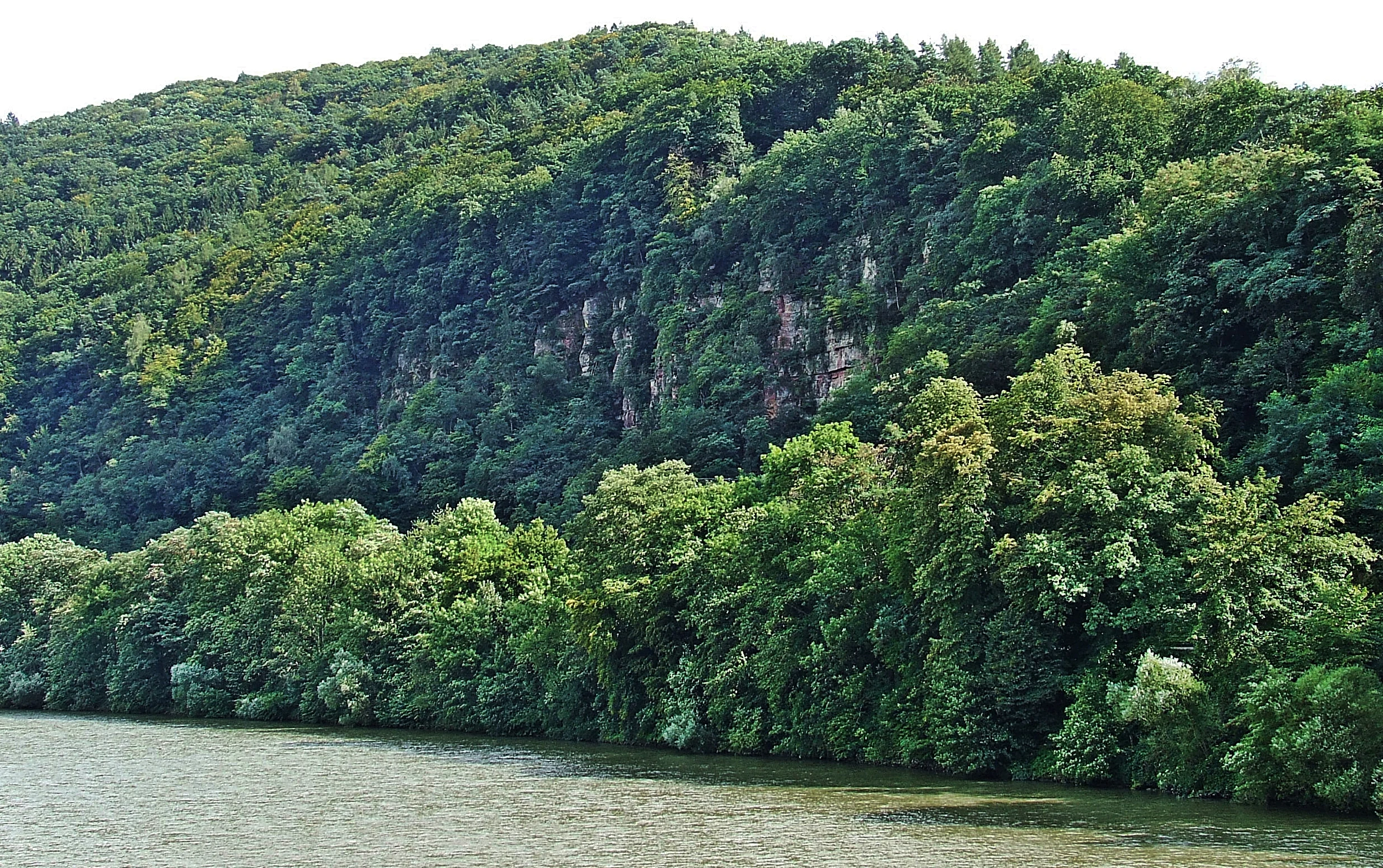
A wide view of a river flowing beneath a steep, forested hillside with visible rock outcrops.
A scenic view of the Neckar River flanked by the forested slopes of the Odenwald.

Neckartal I-Kleiner Odenwald history and protected-area timeline

Landscape protection in the Neckar valley between Neckargemünd and the Little Odenwald has a layered administrative history. Three earlier protection orders from the 1950s, issued by regional authorities in Nordbaden and the former Landesbezirk Baden, had separately protected parts of the Mannbach valley, landscape elements around Heidelberg and Mannheim, and broader tracts in the former Heidelberg and Mosbach districts.

These scattered orders were consolidated by a new regulation of the Landratsamt Rhein-Neckar-Kreis dated 12 July 2002, which established the unified Landschaftsschutzgebiet „Neckartal I-Kleiner Odenwald“. With the new designation, the older 1951, 1953, and 1957 regulations ceased to apply in the affected municipal areas, bringing the protection of the Neckar valley and adjacent Little Odenwald highlands under one coherent framework. The area is administered by the Landratsamt Rhein-Neckar-Kreis, and is catalogued in the World Database on Protected Areas under WDPA ID 323144 and in Baden-Württemberg's official protected-area registry (Kennung 2.26.045).

Neckartal I-Kleiner Odenwald landscape and geographic character

The physical landscape of Neckartal I-Kleiner Odenwald is defined by the interplay between an incised sandstone river valley and a wooded low-mountain upland. The Neckar crosses the area in a series of pronounced bends, leaving behind abandoned meander loops where the river once ran. These old channel arcs, including the Mauererschlinge, the Blumenstrichschlinge, and the Mückenlocherschlinge, now form the curved valley rims around isolated hills such as the Hollmut, the Dilsberg, and the Kirchberg.

The valley flanks themselves alternate between steep undercut slopes (Prallhänge) on the outer curves of the meanders and gentler slip-off slopes (Gleithänge) on the inner sides. Slopes are incised by short tributary valleys and narrow, sharply cut ravines known locally as Klingen, which channel small streams down to the Neckar. Loose sandstone blocks accumulate on some of these slopes as block fields (Blockhalden), supporting specialized rock-field vegetation.

South of the valley, the Little Odenwald rises into a surface of rounded summits, ridges, and shallow depressions, dissected by further stream-cut hollows. Across both the valley and the upland, the combination of forested slopes, open meadows on flatter ground, orchards, and small enclosed field plots produces a densely textured, visually varied landscape with frequent shifts between wood, field, meadow, and rock.

Neckartal I-Kleiner Odenwald ecosystems, habitats, and plant life

Ecologically, Neckartal I-Kleiner Odenwald is characterized by the close proximity of river, slope, and upland habitats, all set on nutrient-poor, acidic Buntsandstein (red sandstone) bedrock. The forests of the valley slopes and high plateaus are dominated by near-natural deciduous woodland, including structural features valued for nature conservation such as old-growth stands, structural transitions at forest edges, and ravine and block forests.

Along the Neckar and its small tributaries, narrow floodplain meadows, reed beds, tall herb communities, and gallery strips of riparian shrubs and trees form a thin but ecologically rich wetland belt. These flowing waters remain largely unaltered, providing habitat for aquatic and streamside species. On steeper slopes and in old quarries, rocky and mineral-rich microhabitats support specialized plant communities, including the distinctive vegetation of the sandstone block fields.

Above the river, the cultural landscape adds further habitat diversity: meadows, fields, orchards (Streuobstbestände), hedgerows, field copses, solitary trees, dry stone walls, earth banks, sunken lanes, ditches, and small rock faces all contribute to a fine-grained mosaic of semi-open habitats. Stau-moist depressions and steep meadows on north-facing slopes retain additional patches of species-rich grassland, reinforcing the area's ecological value as a transition zone between valley and low-mountain environments.

Neckartal I-Kleiner Odenwald wildlife and species highlights

The wildlife profile of Neckartal I-Kleiner Odenwald mirrors the diversity of its habitats: river and streamside zones, deciduous and ravine forests, block-field slopes, old quarries, and a cultural mosaic of meadows, orchards, hedges, and field margins. Native animal and plant species find refuge in old woodlands with mature and decaying trees, in structurally rich forest edges, and in the small landscape elements such as stone walls, hedgerows, and orchard stands that punctuate the open land.

Aquatic and wetland habitats along the Neckar and its small tributaries support communities associated with near-natural flowing water, including reed beds and tall-herb vegetation along the banks. Rocky slopes, block fields, and disused quarries provide microhabitats for rock- and warm-ground specialists, while the meadows, hedges, and orchards of the upland contribute additional niches for pollinators, small mammals, and birdlife typical of mixed low-mountain cultural landscapes in the Odenwald region.

Neckartal I-Kleiner Odenwald conservation status and protection priorities

The regulatory purpose of Neckartal I-Kleiner Odenwald goes well beyond basic landscape protection. The designation is intended to preserve and develop both the Neckar river landscape, with its floodplain, meander relics, undercut slopes, and steep side valleys, and the adjoining Little Odenwald, a varied low-mountain terrain of summits, ridges, hollows, and stream-cut ravines. Particular emphasis is placed on preserving the area's visual beauty, ecological diversity, and distinctive character.

Conservation objectives include maintaining near-natural deciduous forests and structurally rich forest edges, protecting block-field vegetation, safeguarding unaltered watercourses with their gallery forests and floodplain meadows, and preserving the cultural landscape mosaic of meadows, fields, orchards, hedges, field copses, and solitary trees. The regulation also requires protecting habitats of native animal and plant species in hedgerow-rich field systems, mature forests, ravine and block forests, old quarries, and wetland areas.

In addition, the protected landscape framework recognizes the area's high value for public recreation and aims to keep the landscape freely accessible, while securing the long-term functioning of the natural system. This includes protecting soil fertility against erosion, maintaining the balance between forest and open land, and preserving the area's positive influence on local climate and hydrology. The 2002 unified regulation replaced several earlier 1950s protections and brought these aims under a single coherent management framework administered by the Landratsamt Rhein-Neckar-Kreis.

Neckartal I-Kleiner Odenwald cultural meaning and human context

Neckartal I-Kleiner Odenwald reflects a long history of human shaping of the Odenwald landscape. The traditional land use mosaic of meadows, fields, orchards, hedgerows, and small woodland patches has evolved over centuries, producing the fine-grained cultural landscape that the protected status now seeks to maintain. Small structural elements typical of historical rural land use, including dry stone walls, earth banks, sunken lanes, and old field terraces, give the area a distinct local character.

The river landscape itself carries traces of this long interaction with the land: old quarries in the sandstone, abandoned meander loops that once framed riverside settlements, and the network of small tributary valleys that historically supported mills and small-scale agriculture. The Neckartal I-Kleiner Odenwald designation thus protects not only ecological values but also a regionally characteristic cultural landscape along the Neckar and in the Little Odenwald.

Top sights and standout views in Neckartal I-Kleiner Odenwald

The protected area's strongest features are the abrupt transition from the deeply incised Neckar valley to the forested ridges of the Little Odenwald, the encircling abandoned meander loops around landmark hills such as the Hollmut, Dilsberg, and Kirchberg, and the surviving near-natural deciduous forests that clothe many of the slopes. Together with the structured mosaic of meadows, orchards, hedges, and traditional dry-stone field boundaries, these elements define the area's distinctive landscape identity.

Best time to visit Neckartal I-Kleiner Odenwald

As a low-mountain, valley, and woodland landscape in southwestern Germany, Neckartal I-Kleiner Odenwald is appealing in all seasons, though each brings a different character. Spring and early summer highlight fresh deciduous foliage, flowering orchard trees, and streamside vegetation, while late summer and early autumn show the mature greens of the forests and harvested field edges. Winter reveals the structural relief of the sandstone valley most clearly, with bare slopes and block fields standing out against the muted upland forests.

Monthly climate preview

Long-term representative coordinate data detailing monthly temperature and precipitation variation

Neckartal I-Kleiner Odenwald Climate Normals and Average Temperature Rhythms

Representative coordinate records show measured monthly temperature averages ranging from near freezing to warm summer peaks alongside consistent year-round precipitation. Reviewing this detailed annual rhythm helps clarify multi-month meteorological trends across the protected landscape.
Annual mean10 °C
0 °C20 °C
Jan
Feb
Mar
Apr
May14°
Jun18°
Jul20°
Aug20°
Sep15°
Oct10°
Nov
Dec
Warmest month
July

20.3 °C

Coolest month
January

0.1 °C

Wettest month
July

2.4 mm/day

Driest month
April

1.5 mm/day

Park location guide

Geography guide, regional context, and park location map for Neckartal I-Kleiner Odenwald

Neckartal I-Kleiner Odenwald park geography, regions, and map view in Germany

Understand where Neckartal I-Kleiner Odenwald sits in Germany through a broader geographic reading of the surrounding landscape, nearby location context, and its mapped position within the national park landscape.

How Neckartal I-Kleiner Odenwald fits into Germany

Germany is a federal republic in Western and Central Europe with a population of over 83 million across sixteen constituent states. It is Europe's largest economy by nominal GDP and a major global exporter and importer. The capital is Berlin, and the country borders Denmark, Poland, Czech Republic, Austria, Switzerland, France, Luxembourg, Belgium, and the Netherlands.

Wider geography shaping Neckartal I-Kleiner Odenwald in Germany

Germany is located in Western and Central Europe, spanning 357,022 km². It borders Denmark to the north, Poland and the Czech Republic to the east, Austria and Switzerland to the south, and France, Luxembourg, Belgium, and the Netherlands to the west. The country has coastlines on the Baltic Sea and North Sea to the north, with the Alps located in the southern region.

Map view of Neckartal I-Kleiner Odenwald

Use this park location map to pinpoint Neckartal I-Kleiner Odenwald in Germany, understand its exact geographic position, and read its mapped placement within the surrounding landscape more clearly.

Pigeon | © OpenStreetMap contributors

Location context for Neckartal I-Kleiner Odenwald

Baden-WürttembergRhein-Neckar-Kreis

Visualizing the sandstone valleys, river meanders, and forested low mountains of southwestern Germany

Neckartal I-Kleiner Odenwald Photos and Landscape Scenery

Protected area imagery reveals the dramatic transition between deep river valleys and wooded upland ridges across the region. Visual documentation highlights geological formations, deciduous forests, and traditional mosaic habitats characteristic of the protected landscape.

A wide view of a river flowing beneath a steep, forested hillside with visible rock outcrops.

Park atlas

Compare surrounding low-mountain terrain and river valley protected landscapes

Explore Protected Areas and Parks Near Neckartal I-Kleiner Odenwald

Browse other protected areas and regional parks located close to Neckartal I-Kleiner Odenwald in southwestern Germany. Continuing into adjacent natural landscapes provides a broader geographic comparison of sandstone river valleys and forested upland terrain.
A soft watercolor illustration depicting a marshy wetland with rolling hills, trees, and tall grasses in a muted, pastel color palette.
Nature reserveHessen
About 7.4 km away#1 closest

North

Neuzenlache von Viernheim Nature Reserve: Geographic Overview and Protected Landscape Mapping

A rare remnant of an ancient Neckar river arm in Hessen

Neuzenlache von Viernheim offers a focused look at small-scale conservation within the Upper Rhine Plain. This nature reserve provides valuable insight into the transformation of historical river landscapes, featuring a complex of reedbeds and exotic bald cypress trees that mark its unique cultural and natural heritage.

Area
0.091 km²
Established
1990
IUCN
IV
Relief
Lowland
A watercolor-style illustration of a soft, grassy landscape featuring sparse coniferous trees and a gently rolling, light-colored horizon.
Nature reserveHessen
About 7.9 km away#2 closest

North

Glockenbuckel von Viernheim: Mapping the Protected Dunes of Hessen

Nature reserve featuring dry grassland and inland sand biotopes

Located in the Bergstrasse district, Glockenbuckel von Viernheim is a protected area preserving rare inland sand dune landscapes. The site features nutrient-poor sandy soils and open grassland patches maintained for specialized species, reflecting an unusual conservation history born from former military training grounds within the Upper Rhine plain.

Area
0.411 km²
Established
1998
IUCN
IV
A soft watercolor painting depicting a winding river landscape with lush green vegetation, grassy banks, and a treeline in the distance, set against a plain white background.
Nature reserveRheinland-Pfalz
About 8 km away#3 closest

Southwest

Horreninsel Nature Reserve: Detailed Rhine Floodplain Geography and Protected Land Map

A preserved riparian zone in Rheinland-Pfalz, Germany.

Horreninsel represents a significant protected floodplain along the Upper Rhine, featuring a narrow, elongated strip of habitat between the river and its western dike. This reserve hosts diverse terrain, from old river channels and lush Auwald forests to unique Stromtalhalbtrockenrasen dry grasslands, offering a deep look into regional fluvial ecosystems.

Area
0.55 km²
Established
1978
Relief
Lowland
Climate
Temperate
Protected landscapeBaden-Württemberg
About 9.1 km away#4 closest

West

Waldpark Mannheim: Protected Floodplain Landscape and Riparian Geography

Natural fluvial terrain along the Rhine in Baden-Württemberg

Waldpark Mannheim encompasses 150 hectares of protected floodplain forest, meadows, and old Rhine river channels. This landscape serves as a crucial ecological zone, defined by shifting water levels and a lack of artificial flood defenses, illustrating the natural rhythm of riparian habitats in southwestern Germany.

Area
1.496 km²
Established
1975
IUCN
V
Relief
Lowland
A horizontal watercolor painting showing a calm lake or pond surrounded by green trees and shrubs against a soft, light background.
Nature reserveHesse
About 9.6 km away#5 closest

North

Oberlücke von Viernheim Nature Reserve: Mapped Wetland Landscapes in Hesse, Germany

A protected quarry lake refuge for waterbirds and amphibians

The Oberlücke von Viernheim nature reserve represents a significant successional habitat within the Hessian Ried. Formed from an abandoned sand and gravel quarry, its five-hectare water body and surrounding riparian margins serve as a critical wetland sanctuary. This protected area highlights the intersection of industrial legacy and ecological recovery, functioning as a key node for local wildlife in the dense landscape of western Germany.

Area
0.129 km²
Established
1985
IUCN
IV
Relief
Lowland
A pale, soft watercolor painting showing a flat, grassy landscape with distant rolling hills and patches of trees.
Nature reserveRhineland-Palatinate
About 11 km away#6 closest

West

Pfälzische Rheinauen Nature Reserve: Protected Alluvial Landscapes in Rhineland-Palatinate

Regional floodplain geography and protected area map context

The Pfälzische Rheinauen is a major landscape protection area encompassing a mosaic of habitats along the Upper Rhine. From the Haardt mountains eastward, this region features rare alluvial forests, reclaimed gravel pit lakes, and complex river systems. It remains a focal point for understanding the integration of floodplain biodiversity with long-standing human activity in Western Germany.

Area
208.33 km²
Established
1971
Relief
Lowland
Climate
Temperate
A soft watercolor illustration of a wetland scene with a small pool of water in the foreground, a line of deciduous trees in the midground, and rolling hills in the background.
Nature reserveRheinland-Pfalz
About 14 km away#7 closest

Southwest

Neuhofener Woog Nature Reserve: Exploring Rhine Floodplain Geography in Rheinland-Pfalz

Mapping protected swamp forests and ancient river meander ecosystems

Neuhofener Woog serves as a vital protected area in the Rhein-Pfalz-Kreis district. This former Rhine meander preserves a natural transition between water-dominated basins, ash-alder swamp woodlands, and reed beds. It stands as a defined natural landscape within the heavily modified Upper Rhine Plain, offering a clear view of floodplain hydrological patterns.

Area
1 km²
Established
1999
Watercolor painting showing a calm river shoreline with soft green trees and light pinkish ground accents.
Protected areaRhineland-Palatinate
About 15 km away#8 closest

Southwest

Angelhofer Altrhein: Protected Riparian Environment in Rhineland-Palatinate

Historic river oxbow, floodplain forests, and Natura 2000 habitats

Located in the heart of the Upper Rhine plain, the Angelhofer Altrhein constitutes an essential protected area known for its distinct floodplain meadow and forest ecosystems. This backwater environment, once a main channel of the Rhine, provides critical habitat for diverse species and serves as a natural contrast to the surrounding industrial and recreational landscapes of the region.

Relief
Lowland
Climate
Temperate
Access
Easy access
Scope
Terrestrial

Common questions about visiting, size, designation, and location context for Neckartal I-Kleiner Odenwald

Neckartal I-Kleiner Odenwald FAQs for park facts, access, geography, and protected area context

Find quick answers about Neckartal I-Kleiner Odenwald, including protected-area facts, park geography, trail and visitor context, and how the park fits into its surrounding country and regional landscape.
MoriAtlas Explorer

Continue Your Protected Areas Search Across the Global Atlas

Deepen your exploration by continuing the structured search for national parks and protected areas worldwide. Utilize the comprehensive filtering capabilities to compare different conservation landscapes and refine your understanding of global park geography. Discover more about the distribution and characteristics of protected natural areas.

Global natural geography