Why Nissum Bredning stands out
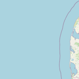
Nissum Bredning is best known for being the broad, shallow western gateway of the Limfjorden where the waterway meets the North Sea via the Thyborøn Channel. The bay is characterized by large sand banks and sub-tidal flats such as Fjordgrund and Gåseholm, formed from sand washed in through the channel, rather than by deep fjord scenery. The area is also notable for its mix of glacial and coastal landforms along the eastern shore, including the steep Toftum Bjerge cliff with tilted strata from three different ice ages, the narrow low-tide sand spit known as Draget, and lagoon-like coastal lakes such as Hygum Nor and Gjeller Sø. Together, these features make Nissum Bredning a textbook example of a low-lying, sand-dominated western Limfjorden basin shaped by both glacial history and ongoing coastal dynamics.
Nissum Bredning landscape and geographic character
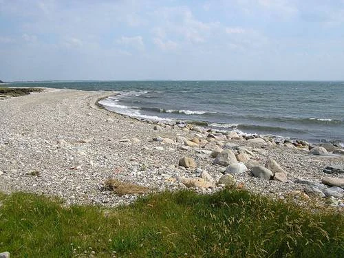
Nissum Bredning sits in a low, flat corner of the Limfjorden landscape, with most of the shoreline barely above sea level. The dominant physical feature is the vast sand-flats system of Fjordgrund and Gåseholm in the western part of the bay, created by sand carried in through the Thyborøn Channel and reshaped by currents and wind. These shallow banks rise only a meter or two above the seabed and give the western bay its quiet, open character.
Along the southern edge, the landscape softens further into the long, narrow Harboøre Tange and the curving mainland coast near Harboøre, where streams and lagoon-like basins such as Hygum Nor and Gjeller Sø interrupt the otherwise smooth shoreline. The southern coastal belt is shaped as much by freshwater drainage from inland lakes as by direct sea influence, creating a patchwork of fjord water, brackish lagoons, and wet meadows.
The eastern side of the bay contrasts sharply with the rest. Here, the Toftum Bjerge cliff rises several tens of meters above the water, exposing tilted layers that record three separate glaciations. This cliff anchors the eastern edge visually and acts as a hinge between the broad bay and the narrower stretch of Limfjorden that continues toward Oddesund. North of Toftum, the landscape returns to a low form, with the thin sand spits of Grisetåodde and Draget wrapping around the southern tip of Thyholm and defining the narrow boundary between Nissum Bredning, Skibsted Fjord, and the Kattegat-facing coast.
Nissum Bredning ecosystems, habitats, and plant life
Ecologically, Nissum Bredning is defined by its shallow, sunlit waters and the long, flat sand banks that occupy much of the western basin. These conditions support rich benthic communities and attract large numbers of waterbirds that depend on the interface between open water, tidal flats, and adjacent meadows. Salt-influenced meadows, reed-fringed lagoon edges, and freshwater inputs from inland streams create a mosaic of slightly different habitat conditions within a relatively small area.
The meadows and lagoon systems around Harboøre Tange, Sønderholme Enge, Plet Enge, and Gjeller Sø supply a particularly important set of wetland habitats along the southern shore. The eastern edge near Toftum Bjerge adds a different element, with exposed clay and till slopes that support specialized plant communities along with panoramic views over the broader Limfjorden landscape. Together, these zones mean that although Nissum Bredning is shallow and flat, it hosts a layered ecological structure that shifts quickly from open water to vegetated shore to steep glacial cliff.
Nissum Bredning conservation status and protection priorities
Nissum Bredning lies within Natura 2000 area number 28, which groups it together with Agger Tange, Skibsted Fjord, and Agerø as a single coordinated protection complex. Within this framework, the bay has been designated as a bird protection area, a habitat area, and a Ramsar wetland of international importance, reflecting both its ecological character and its value for migratory and breeding waterbirds.
Practical protection on the ground has come in several stages. In 1984, the Harboøre and Agger tangen were placed under nature protection, covering roughly 2,400 hectares in total. In the same year, a 200-hectore area east of Harboøre, made up of Sønderholme Enge and Plet Enge, was protected specifically to conserve a range of plant species. A further 90 hectares near Gjeller Sø lagoon were protected around Gjeller Odde, and on the eastern side of the bay, around 49 hectares were protected at Åmølle and Gejlgård Bakke near Toftum Bjerge, where the protected land also provides viewpoints over the surrounding Limfjorden landscape.
Top sights and standout views in Nissum Bredning
Nissum Bredning stands out for its wide expanse of shallow sand flats in the western Limfjorden and for the striking Toftum Bjerge cliff on the eastern shore, where tilted glacial layers from three ice ages are exposed in a single section of coast. The bay is also a key migratory and coastal-bird area, recognized under Natura 2000 and the Ramsar Convention, with multiple nature reserves along its shores including Harboøre Tange, Sønderholme Enge, Plet Enge, and Gjeller Odde. The presence of offshore wind turbines on the sand banks and the long Oddesund Bridge at its eastern entrance give the bay a distinctive blend of active human use and large-scale nature protection.
Best time to visit Nissum Bredning
The character of Nissum Bredning shifts with the seasons in ways typical of shallow Danish coastal bays. Spring and early summer tend to bring active birdlife around the meadows and sand flats, especially in the protected areas around Harboøre Tange and Gjeller Sø, while summer daylight is long and the Toftum Bjerge cliff and the surrounding countryside are most easily appreciated from viewpoints such as Gejlgård Bakke. Late summer and autumn often bring migratory birds passing through the bay and shifting water levels over the shallow sand banks, and winter can offer the most atmospheric, quiet views across the broad, flat water and along the low tangen. Because conditions are dominated by weather and visibility rather than by dramatic seasonal access changes, the bay is broadly accessible year-round, though calm, clear days tend to give the best sense of its open landscape.