

Mori Atlas logo
National parkNosy Mangabe

Examining the ecological boundaries and maritime landscape of this unique island sanctuary.

Nosy Mangabe National Park: An Atlas of Protected Rainforests and Island Geography in Ambatosoa

(Nosy Mangabe National Park)

Nosy Mangabe represents a critical protected landscape situated within the sheltered waters of Antongil Bay off the northeast coast of Madagascar. This small forested island serves as a vital refuge for endangered lemur populations and preserves a distinct lowland rainforest ecosystem. Map-based analysis of the terrain reveals a compact, steep-sided environment that integrates primary forest cover with deep historical layers of maritime activity. Its protected status provides a controlled setting for primate research and conservation across the broader Ambatosoa region.

rainforestisland reservelemursaye-ayeprimate conservationtropical forest

Nosy Mangabe

National park

Park overview

Structured park overview, official facts, and landscape profile for Nosy Mangabe

Nosy Mangabe park facts, protected area profile, and essential visitor context

Review the core facts for Nosy Mangabe, including designation, size, terrain, visitor scale, habitats, and operating context in one park-focused overview.

About Nosy Mangabe

Nosy Mangabe is a rainforest island national park in Antongil Bay, northeastern Madagascar, forming a small but ecologically important component of the greater Masoala National Park complex. Though modest in size compared with the surrounding mainland reserves, the island functions as a refuge for threatened lemurs, a site of ongoing primatological research, and a key destination for eco-tourists exploring the bay. Its protected status and strong institutional partnerships with both national and international conservation bodies help safeguard one of the region’s most fragile rainforest ecosystems.

The island’s environment is shaped by the climate of eastern Madagascar’s humid coast. Dense canopy, undergrowth thick with ferns and climbing plants, and very high annual rainfall support a forest type that is increasingly rare elsewhere in the country. Because Nosy Mangabe has never supported permanent human settlement, its habitat remains largely intact, providing an unusually pristine environment for arboreal species such as lemurs. This combination of small size and high ecological integrity gives the reserve an outsized importance within Madagascar’s network of protected areas.

Nosy Mangabe also plays a role in the cultural and scientific identity of Antongil Bay. Its past as a stopover for traders and pirates, its rock carvings left by European seafarers, and its association with conservationists and naturalists all contribute to a layered human history that complements its natural significance. Visitors typically arrive by boat from Maroantsetra, using the island as a base for day hikes, night walks to observe nocturnal lemurs, and exploration of the broader Masoala coastline.

Quick facts and research context for Nosy Mangabe

Nosy Mangabe lies within Antongil Bay, close to the town of Maroantsetra in northeastern Madagascar. The island is administered as part of Masoala National Park, one of the most significant rainforest protected areas in the country. Its status as a national park places it within IUCN Category II, indicating a strictly protected natural area managed for ecosystem conservation.

The reserve covers an area of approximately 90 square kilometers within the broader Masoala complex, while the island itself spans roughly 520 hectares of dense humid forest. Nosy Mangabe receives very high annual rainfall, supporting the lush vegetation characteristic of eastern Madagascar’s lowland rainforests. It is governed through a partnership between the Madagascar National Parks Association and the Wildlife Conservation Society, reflecting both national management and international conservation collaboration.

Protection and recognition

Documented terrestrial protection scope and official designation records for Nosy Mangabe

Nosy Mangabe Protection Status and Conservation Recognition Data

Terrestrial protection parameters and administrative scope define the official conservation framework governing Nosy Mangabe. Documented designation metrics provide structured reference values for examining international recognition and territorial management parameters.

Protection details

Protection scope
Terrestrial
Park context

Deeper park guide and search-rich context for Nosy Mangabe

Nosy Mangabe history, landscape, wildlife, and travel context

Explore Nosy Mangabe through its history, landscape character, ecosystems, wildlife, conservation priorities, cultural context, and seasonal travel timing in a structured park guide built for atlas discovery and search intent.

Why Nosy Mangabe stands out

Nosy Mangabe is best known for its role as a refuge for the aye-aye, one of the most unusual and threatened lemurs in Madagascar. Aye-ayes were translocated to the island in the 1960s after centuries of persecution on the mainland, where local cultural beliefs associating the animal with bad omens had driven populations to the brink of extinction. The island’s isolation and intact forest cover provided a sanctuary where the species could recover under protection. Beyond the aye-aye, the reserve is recognized for its exceptionally humid lowland rainforest. Dense vegetation, high rainfall, and a varied primate community that includes four additional lemur species distinguish Nosy Mangabe within the wider Masoala landscape. The combination of primate conservation, primary rainforest, and proximity to a major national park gives the island an outsized profile in Madagascar’s protected-area system.
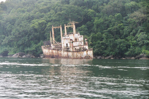
A rusted, derelict ship remains beached or anchored near a dense, green tropical forest coastline along calm water.
The wreck of a ship resting against the forested coastline of Nosy Mangabe.

Nosy Mangabe history and protected-area timeline

Nosy Mangabe carries a long human history layered onto its natural landscape. The island lies close to traditional maritime routes through Antongil Bay and was used by traders and pirates in earlier centuries. On the western side of the island, rock carvings left by Dutch sailors in the 16th century stand as enduring evidence of European contact with Madagascar’s northeast coast. In the 17th century, French arrivals established a trading post in the area, embedding the island in the early commercial history of the region.

The modern conservation history of the island began in the 20th century. Nosy Mangabe was formally established as a reserve in 1965, adding it to Madagascar’s growing system of protected natural areas. A defining moment came in the 1960s, when aye-ayes were translocated to the island from declining mainland populations, an effort aimed at protecting the species from local persecution. The reserve has since been managed under IUCN Category II, with stewardship shared between national park authorities and conservation partners.

In the late 20th century, Nosy Mangabe gained wider cultural recognition through British writer Douglas Adams, who visited the island while researching aye-ayes for the radio series and book Last Chance to See. His writings introduced many international readers to the island’s lemurs, the challenges facing Madagascar’s forests, and the quiet drama of species recovery through translocation.

Nosy Mangabe landscape and geographic character

Nosy Mangabe rises from the sheltered waters of Antongil Bay as a small, steep-sided island blanketed in rainforest. The terrain is characterized by compact topography rather than dramatic elevation, with the whole island covered by dense vegetation that descends toward the shoreline. From the bay, the island reads as a wall of green, broken occasionally by rocky points, small beaches, and areas where historic shipwrecks lie half-submerged along the west coast.

Within the island, narrow footpaths wind through deep shade, roots, and ferns, giving the interior a close, enclosed feel. The forest canopy is broad and continuous, and the persistent humidity keeps the air heavy and the vegetation lush year-round. Although the island is small, the sense of depth and immersion created by the unbroken forest is striking, particularly as the terrain shifts between slopes, depressions, and small interior clearings.

The viewpoint from the island’s higher points offers a sweeping perspective over Antongil Bay and the forested coastline of the Masoala peninsula. Sea and rainforest together form the dominant visual character of the reserve, a juxtaposition of tropical marine scenery and one of the wettest forest environments in Madagascar.

Nosy Mangabe ecosystems, habitats, and plant life

The island’s dominant ecosystem is dense humid tropical rainforest, representative of the broader Masoala lowland forest system. Annual rainfall on Nosy Mangabe is exceptionally high, sustaining a perpetually moist, shaded environment. The forest structure includes a tall, closed canopy, an understory rich in ferns, lianas, and broad-leafed plants, and a deep litter layer that supports an active community of invertebrates. The combination of isolation and absence of permanent human settlement has helped the island retain a largely intact forest cover.

Within this habitat, plants such as Baron’s climbing rosewood, a vulnerable tree species also known as Dalbergia baronii, contribute to a flora shaped by long rainforest continuity. The lack of disturbance on the island has created favorable conditions for species that depend on mature canopy and large tree cavities. Together, these qualities give the island an ecological character that mirrors Madagascar’s eastern rainforest zone at a small, protected scale.

Nosy Mangabe wildlife and species highlights

Nosy Mangabe is internationally recognized for its population of aye-aye, an endangered nocturnal lemur that was introduced to the island as a refuge from mainland persecution. The aye-aye’s unusual foraging behavior, including its use of elongated fingers to extract insects from wood, has made it both a subject of scientific research and one of Madagascar’s most iconic conservation symbols. Local cultural traditions once linked the aye-aye to misfortune, contributing to its precarious status across its wider range.

In addition to the aye-aye, four other lemur species inhabit the island: the eastern woolly lemur, the white-fronted lemur, the black-and-white ruffed lemur, and the gray mouse lemur. Together with the aye-aye, these primates give Nosy Mangabe one of the densest lemur communities of any small protected area in Madagascar. Each species occupies a slightly different role in the forest, from nocturnal foragers to diurnal canopy dwellers.

While the lemurs are the primary wildlife attraction, the island’s unbroken forest also supports a wider community of forest birds, reptiles, amphibians, and invertebrates typical of the Masoala region. The dense vegetation and humid conditions provide habitat for species throughout the food web, making the island a rich site for naturalists and researchers interested in the full array of lowland rainforest biodiversity.

Nosy Mangabe conservation status and protection priorities

Nosy Mangabe plays a significant role in Madagascar’s broader conservation strategy, particularly for lemurs and lowland rainforest ecosystems. Designated as a national park under IUCN Category II, it is part of the Masoala National Park complex, one of the largest rainforest protected areas in the country. Its inclusion within this complex extends the benefits of protection to a continuous landscape of forest and bay that would otherwise face fragmentation pressures.

The island’s importance is amplified by its role as a refuge for the aye-aye. Classified as endangered by the International Union for Conservation of Nature, the aye-aye has historically suffered from habitat loss and cultural persecution. Translocation to Nosy Mangabe in the 1960s provided an isolated, undisturbed environment where the species could stabilize. Continued protection on the island remains a critical insurance population within the overall conservation plan for the species.

Governance is shared between the Madagascar National Parks Association and the Wildlife Conservation Society, a partnership model that combines national authority with international scientific capacity. This collaboration supports not only day-to-day protection but also research efforts that inform broader conservation decisions across the Masoala region.

Nosy Mangabe cultural meaning and human context

Nosy Mangabe’s cultural connections stretch from pre-colonial local tradition to European maritime exploration. Long before it became a scientific reserve, the island featured in the maritime history of Antongil Bay, a region associated with seasonal traders, sailors, and pirates moving along Madagascar’s northeastern coast. Rock carvings on the western side, attributed to Dutch visitors in the 16th century, mark one of the earliest documented European encounters with the island, while later French activity in the 17th century further embedded the bay in early colonial trade networks.

The reserve also carries significant cultural weight in the context of aye-aye conservation. Across parts of mainland Madagascar, the aye-aye has long been viewed with fear and superstition, traditionally considered an ill omen. This cultural context shaped the species’ decline and shaped the logic of translocating individuals to Nosy Mangabe, where they would be safe from these pressures. The island thus sits at an intersection of cultural belief, environmental change, and species protection.

In the modern era, Nosy Mangabe has appeared in popular culture through the work of British writer Douglas Adams, whose travels to the island helped introduce wider audiences to Madagascar’s primates and rainforest conservation. The island continues to feature in environmental writing, ecotourism narratives, and the working life of researchers who use its base camp as a home for fieldwork across the Masoala peninsula.

Top sights and standout views in Nosy Mangabe

Nosy Mangabe’s standout qualities begin with its extraordinary primate community in a remarkably compact forest setting. The presence of five lemur species, anchored by the endangered aye-aye, gives the island an animal profile that punches well above its size. For visitors and researchers alike, the chance to observe rare primates in an intact rainforest environment is the island’s defining experience.

Equally striking is the island’s layers of history and landscape heritage. Dutch rock carvings, French colonial trade networks, and the remains of shipwrecks along the coast connect the reserve to broader Atlantic and Indian Ocean maritime history. Together with the surrounding waters of Antongil Bay and the forested slopes of the Masoala peninsula, the island offers a blend of natural and cultural features rare within any single protected area.

Best time to visit Nosy Mangabe

Nosy Mangabe can be visited year-round, but the character of the island shifts with the seasons. The northeast coast of Madagascar generally experiences a warmer, wetter period that intensifies the forest’s humidity and brings heavy rains, while a drier period offers cooler temperatures and reduced precipitation. Travelers interested in clearer views across Antongil Bay and more comfortable hiking conditions often prefer the drier stretch of the year, when the forest trails are easier to navigate and the coastline is calmer for boat travel.

For those focused on wildlife, particularly nocturnal lemurs like the aye-aye, overnight stays are recommended regardless of season. Cooler nights, reduced insect activity, and less chance of rain often make the darker months more pleasant for guided night walks. The lush conditions of the wetter season, however, showcase the rainforest at its most vibrant, with saturated foliage and full canopy cover.
Monthly climate preview

Long-term representative temperature and precipitation averages for Ambatosoa

Nosy Mangabe Climate Normals and Measured Annual Weather by Month

Representative coordinate records show mean temperatures ranging from 19.11 degrees Celsius to 24.26 degrees Celsius alongside varied daily precipitation rates across the annual cycle. Reviewing the complete monthly climate normals for Nosy Mangabe provides granular insight into historical temperature swings and precipitation patterns.
Annual mean22 °C
19 °C24 °C
Jan24°
Feb24°
Mar24°
Apr23°
May22°
Jun20°
Jul19°
Aug19°
Sep20°
Oct21°
Nov23°
Dec24°
Warmest month
February

24.3 °C

Coolest month
August

19.1 °C

Wettest month
March

11.9 mm/day

Driest month
October

2.7 mm/day

Park location guide

Geography guide, regional context, and park location map for Nosy Mangabe

Nosy Mangabe park geography, regions, and map view in Madagascar

Understand where Nosy Mangabe sits in Madagascar through a broader geographic reading of the surrounding landscape, nearby location context, and its mapped position within the national park landscape.

How Nosy Mangabe fits into Madagascar

Madagascar is an island nation in the Indian Ocean, positioned off the southeastern coast of Africa. As the world's fourth-largest island and second-largest island country, it stands out for its exceptional biodiversity, over 90% of its wildlife is endemic, making it one of 17 megadiverse countries. The population is approximately 32 million, with Antananarivo as both the capital and largest city.

Wider geography shaping Nosy Mangabe in Madagascar

Madagascar lies in the Indian Ocean off the southeastern coast of Africa, separated from the mainland by the Mozambique Channel. The island is situated approximately 400 km from the African continent. As the world's fourth-largest island, it also includes numerous smaller peripheral islands.

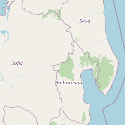
Map view of Nosy Mangabe

Use this park location map to pinpoint Nosy Mangabe in Madagascar, understand its exact geographic position, and read its mapped placement within the surrounding landscape more clearly.

Pigeon | © OpenStreetMap contributors

Location context for Nosy Mangabe

Ambatosoa

Visualizing the terrain, dense canopy, and tropical marine scenery of Madagascar's island sanctuary

Nosy Mangabe Photos and Protected Rainforest Landscape Imagery

Examine detailed photographs capturing the dense lowland rainforest terrain and protected island habitats of Nosy Mangabe. Visual archives illustrate the steep coastal slopes, continuous canopy, and unique environment supporting rare nocturnal primates.

A rusted, derelict ship remains beached or anchored near a dense, green tropical forest coastline along calm water.

Park atlas

Compare regional biodiversity and connected tropical forest habitats across Madagascar

Explore Parks Near Nosy Mangabe and Surrounding Protected Landscapes

Browse other parks near Nosy Mangabe to uncover related lowland rainforest reserves and wildlife habitats. Comparing protected areas across the surrounding region expands geographic context for Madagascar ecosystems.
National parkSava Region
About 15 km away#1 closest

East

Masoala National Park: Explore Madagascar's Largest Protected Landscape and Marine Ecosystems

Discover the unique geographic features and rich biodiversity of this Sava Region national park.

Masoala National Park represents a critical protected landscape in Madagascar's Sava Region, spanning the vast Masoala Peninsula. The park's protected territory covers a remarkable range of ecosystems, including lowland and montane rainforests, coastal habitats, and extensive marine areas with coral reefs. Understanding the geographic scope and ecological diversity of Masoala National Park provides essential context for appreciating Madagascar's unique natural heritage and the importance of its conservation efforts.

Area
2,400 km²
Established
1997
IUCN
II
Visitors
3K annual
National parkMadagascar
About 26 km away#2 closest

West

Makira Natural Park: Exploring the Geography and Forested Terrain of Northeastern Madagascar

A vital protected landscape in the humid northeastern forest belt.

Makira Natural Park serves as a benchmark for integrated tropical conservation in Madagascar. Its humid evergreen forests provide a critical habitat for high lemur diversity and specialized botanical associations linked to unique geological substrates. This protected area connects to a larger regional landscape of community-managed forests, acting as a crucial buffer for the biodiversity of the northeastern coastal regions.

Area
3,724.7 km²
Established
2012
IUCN
II
Relief
Mountain
National parkMadagascar
About 74 km away#3 closest

South

Mananara Nord National Park: National Park Geography and Protected Landscape Identity

Explore its mapped boundaries within Madagascar's diverse geography.

Mananara Nord National Park represents a vital protected landscape within Madagascar, offering users a direct entry point for exploring its specific geographic character. As a designated national park, it contributes significantly to the atlas of conservation lands on the island nation. This park provides a focused lens through which to examine regional geography and the mapped extent of protected natural areas, anchoring its identity within the broader context of Madagascar's unique ecological landscape.

Wildlife reserveAnalanjirofo
About 85 km away#4 closest

Southwest

Réserve spéciale d'Ambatovaky: Protected Forest Landscape and Wildlife Reserve in Analanjirofo

Mapping rugged terrain and endemic forest ecosystems in northeastern Madagascar.

Réserve spéciale d'Ambatovaky spans a challenging, topographically complex area of northeastern Madagascar. This wildlife reserve consists of an unbroken canopy of humid lowland and hill forests, providing a critical refuge for rare raptors and diverse primate communities within the Analanjirofo region's mountainous terrain.

Area
600.5 km²
Established
1958
IUCN
IV
Relief
Upland
Wildlife reserveSava
About 96 km away#5 closest

North

Réserve spéciale d'Anjanaharibe-Sud: Geography and Protected Area Landscape Overview

Deep forest terrain and mountain ridges in the Sava region

Situated in northeastern Madagascar, Réserve spéciale d'Anjanaharibe-Sud encompasses dense evergreen forests and steep mountain terrain. This protected area serves as a significant conservation landscape for rare endemic species, providing a high-elevation habitat that climbs dramatically from 500 meters to peaks above 2,000 meters across the Sava region.

Area
182.56 km²
Established
1958
IUCN
IV
Relief
Mountain
Watercolor painting of a mountainous landscape with green vegetation, a body of water, and distant peaks under a light sky
National parkMadagascar
About 116 km away#6 closest

North

Marojejy National Park: A Protected National Park within Madagascar's Unique Geography

Mapped landscape context and regional protected area significance.

Marojejy National Park is a distinct protected area offering rich insights into Madagascar's natural geography. As a national park, its mapped boundaries define a significant landscape that contributes to the island nation's reputation as a biodiversity hotspot. This entry provides essential context for understanding Marojejy National Park's role within the country's protected lands and its value for structured geographic atlas exploration.

Area
555 km²
Established
1998
IUCN
II
Relief
Mountain
Wildlife reserveSofia region
About 183 km away#7 closest

Southwest

Tampoketsa Analamaitso Reserve: Wildlife Reserve and Protected Forest Geography in Sofia Region

Ecological transition zone featuring humid and dry forest biomes

Tampoketsa Analamaitso Reserve provides a protected sanctuary for northern Madagascar's primate fauna, defined by its rare combination of humid mid-altitude and dense dry forest ecosystems. Managed for habitat conservation, the reserve remains a remote wilderness area with intact forest cover that stretches across the Sofia region. Its geographic importance lies in the ecological gradient that links distinct upland and lowland vegetation types, offering a comprehensive look at the island's diverse natural terrain.

Area
171.5 km²
Established
1958
IUCN
IV
Relief
Upland
Nature reserveDiana
About 197 km away#8 closest

Northwest

Réserve naturelle intégrale de Tsaratanana: Highland Massif and Protected Mountain Terrain

High-altitude geography in the Diana region of northern Madagascar

Spanning tens of thousands of hectares, the Réserve naturelle intégrale de Tsaratanana protects the highest mountain terrain in Madagascar. The landscape is defined by the crystalline Vohibory massif, creating a complex topography of deep valleys and dramatic elevation gradients that support endemic primate habitats and montane forest ecosystems.

Area
486.22 km²
Established
1927
IUCN
Ia

Common questions about visiting, size, designation, and location context for Nosy Mangabe

Nosy Mangabe FAQs for park facts, access, geography, and protected area context

Find quick answers about Nosy Mangabe, including protected-area facts, park geography, trail and visitor context, and how the park fits into its surrounding country and regional landscape.
MoriAtlas Explorer

Continue Your Protected Areas Search Across the Global Atlas

Deepen your exploration by continuing the structured search for national parks and protected areas worldwide. Utilize the comprehensive filtering capabilities to compare different conservation landscapes and refine your understanding of global park geography. Discover more about the distribution and characteristics of protected natural areas.

Global natural geography