Mori Atlas logo
Nature reserveNtsikeni Nature Reserve

Explore the geographic boundaries and unique plateau terrain of this remote South African protected area.

Ntsikeni Nature Reserve: Mapping the High-Altitude Wetlands and Drakensberg Foothill Landscapes

Ntsikeni Nature Reserve encompasses a vast, high-elevation wetland basin situated within the southern KwaZulu-Natal foothills of the Drakensberg escarpment. Perched at approximately 1,750 metres above sea level, the reserve functions as a critical headwater source for the Umzimkulu River system. This protected landscape preserves a rare combination of mist-shrouded montane grasslands, orchid-rich habitats, and seasonal snow-covered plateau environments that remain relatively undisturbed in their natural state.

wetlandRamsar siteDrakensberg foothillshigh-elevation plateaumontane grasslandbirdwatching

Ntsikeni Nature Reserve

Nature reserve

Park overview

Structured park overview, official facts, and landscape profile for Ntsikeni Nature Reserve

Ntsikeni Nature Reserve park facts, protected area profile, and essential visitor context

Review the core facts for Ntsikeni Nature Reserve, including designation, size, terrain, visitor scale, habitats, and operating context in one park-focused overview.

About Ntsikeni Nature Reserve

Ntsikeni Nature Reserve is one of the most distinctive wetland protected areas in South Africa, combining high-elevation wetland habitat with the broader ecological character of the southern Drakensberg foothills. Located in the Griqualand East region of southern KwaZulu-Natal, between the small towns of Creighton and Franklin, the reserve lies in a remote part of the country where the Drakensberg meets the interior plateau. The surrounding landscape is shaped by rolling foothills, montane grassland, and the rising edge of the Drakensberg escarpment, providing a setting that feels both expansive and secluded.

The centerpiece of the reserve is a large wetland perched on a very high plateau, reaching approximately 1,750 metres above sea level. Because of this elevation, the wetland is one of the highest in South Africa and is also the country's largest wetland in terms of extent. The climate at this altitude is cool, and the area is frequently blanketed in thick mist or rises through a mist layer into clear air above. Snowfall is an annual occurrence, giving the wetland and its surroundings a distinctly seasonal character that contrasts with most other South African wetland systems.

Beyond the wetland itself, the reserve extends across roughly 9,200 hectares of Drakensberg foothill terrain. This combination of wetland, grassland, and montane habitats supports a rich diversity of plant and animal life, including around 1,300 plant species and more than 120 bird species. The area is also recognised as a Ramsar Wetland of International Importance, reflecting both its biodiversity values and its function as part of the headwaters of the Umzimkulu River, which drains northward from the reserve and supports downstream communities and ecosystems.

Ntsikeni's protected status and its remoteness have helped shield it from many of the pressures affecting more accessible wetlands in the region. Poor road conditions and limited infrastructure inside the reserve contribute to this low-impact character, and the reserve is used primarily for quiet activities such as hiking, horse riding, mountain biking, and wildlife viewing rather than for mass tourism. This balance between ecological protection and limited, low-intensity visitor use is central to the reserve's identity.

Quick facts and research context for Ntsikeni Nature Reserve

Ntsikeni Nature Reserve is located in southern KwaZulu-Natal, South Africa, within the Griqualand East area, and lies in the foothills of the Drakensberg between Creighton and Franklin. The reserve covers roughly 9,200 hectares, of which about 1,070 hectares are wetland on a high plateau reaching approximately 1,750 metres above sea level. It is both the largest and one of the highest wetlands in South Africa.

The reserve is managed by Ezemvelo KZN Wildlife, was first declared a nature reserve in 1978, and was realigned into KwaZulu-Natal from the Eastern Cape in 2006 through a boundary adjustment. In 2010 it was designated as a Ramsar Wetland of International Importance, recognising its ecological significance and its role in feeding the headwaters of the Umzimkulu River.

Protection and recognition

Documented terrestrial designation history and Ramsar source records

Ntsikeni Nature Reserve Protection Status and International Recognition

Ntsikeni Nature Reserve holds a documented terrestrial protection status established in 2010 alongside official Ramsar wetland recognition records. Official management scope and historical designation data outline the framework governing this protected area.

International recognition

Protection details

Protection scope
Terrestrial
Designated year
2010
Transboundary protection
No
Park context

Deeper park guide and search-rich context for Ntsikeni Nature Reserve

Ntsikeni Nature Reserve history, landscape, wildlife, and travel context

Explore Ntsikeni Nature Reserve through its history, landscape character, ecosystems, wildlife, conservation priorities, cultural context, and seasonal travel timing in a structured park guide built for atlas discovery and search intent.

Why Ntsikeni Nature Reserve stands out

Ntsikeni is best known for hosting the largest and one of the highest-elevation wetlands in South Africa, sitting on a misty Drakensberg plateau at around 1,750 metres above sea level. The reserve is also recognized for its Ramsar designation, its exceptional plant diversity with dozens of orchid species, and its importance for waterbirds and grassland antelope that depend on the wetland and surrounding montane grasslands. The combination of a cold, frequently mist-shrouded wetland plateau with neighbouring foothills and Drakensberg scenery gives the reserve a distinctive feel within the South African protected-area network. It is also valued for its remote, relatively undisturbed character and for the role the wetland plays as a headwater source for the Umzimkulu River system.

Ntsikeni Nature Reserve history and protected-area timeline

The area that now forms Ntsikeni Nature Reserve was formally declared a nature reserve in 1978, establishing its protected status under the conservation framework of the time. For much of its early history it lay within a different provincial jurisdiction, and in 2006 a boundary adjustment moved it from the Eastern Cape into KwaZulu-Natal, reflecting changes in provincial administrative boundaries in post-apartheid South Africa.

The most significant milestone in the reserve's development came on 2 February 2010, when Ntsikeni was designated as a Ramsar Wetland of International Importance under the Ramsar Convention. This designation recognised the wetland's exceptional ecological value, its role as one of the largest and highest wetlands in the country, and its importance for water supply and biodiversity downstream. The reserve continues to be managed by Ezemvelo KZN Wildlife, the provincial conservation authority for KwaZulu-Natal.

Ntsikeni Nature Reserve landscape and geographic character

The landscape of Ntsikeni Nature Reserve is defined by the transition between the southern Drakensberg foothills and a high-elevation plateau that supports the country's largest wetland. The terrain rises into a misty high plateau around 1,750 metres above sea level, with the highest parts of the reserve often lost in cloud or rising into clear air above the mist line. This elevation gives the reserve a cool, often alpine-feeling atmosphere unusual for South African wetlands.

The wetland itself occupies a flat, high plateau basin surrounded by rolling foothills that gradually climb toward the Drakensberg escarpment. Snow is a regular seasonal feature of this upper landscape, transforming the wetland and surrounding grassland in winter. The roads within the reserve are in poor condition, which adds to the sense of remoteness and has helped preserve the relatively unmodified character of the terrain.

Water flows from the wetland northward, contributing to the headwaters of the Umzimkulu River. This hydrological setting is one of the defining features of the landscape: a high-altitude wetland functioning as a source-water area, embedded in a broader matrix of Drakensberg foothills and montane grassland that stretches toward towns such as Creighton, Franklin, Kokstad, Himeville, and Underberg.

Ntsikeni Nature Reserve ecosystems, habitats, and plant life

Ntsikeni supports a rich mix of wetland, grassland, and montane habitats compressed into a relatively confined area. The central wetland is the ecological anchor of the reserve, supporting both wetland-specific vegetation and the broader plant communities of a high-altitude plateau. Around 1,300 plant species have been recorded across the reserve, including roughly 65 species of orchids, reflecting the unusual overlap of wetland, grassland, and Drakensberg foothill flora.

The surrounding landscape is dominated by montane and submontane grassland that grades into the Drakensberg foothills. This combination of habitats creates ecological transitions over short distances, with wetland margins, open grassland, rocky slopes, and mist belt vegetation all contributing to the reserve's botanical richness. The remote and relatively undisturbed character of the area has helped preserve habitat patterns that have been altered in more accessible parts of the region.

Hydrologically, the reserve functions as an important headwaters system, with the wetland feeding northward into the Umzimkulu River. This makes Ntsikeni ecologically significant beyond its boundaries, with its water resources supporting both downstream ecosystems and rural communities that depend on the river system.

Ntsikeni Nature Reserve wildlife and species highlights

The wetland and grassland habitats of Ntsikeni support a diverse and ecologically meaningful wildlife community, particularly in terms of birdlife. More than 120 bird species have been recorded in the reserve, including several species of conservation concern that depend on the combination of high-elevation wetland and surrounding grassland. Among the notable species associated with the area are the Eurasian bittern, wattled crane, African rail, flufftail, African grass owl, Cape vulture, bearded vulture, yellow-breasted pipit, Southern bald ibis, black harrier, purple heron, Cape eagle-owl, African marsh harrier, and Denham's bustard, along with various songbirds in the Cisticolidae family.

The reserve also supports a range of mammals typical of Drakensberg foothill and wetland-edge environments. Species recorded include Southern reedbuck, African clawless otter, oribi, mountain reedbuck, grey rhebok, and common duiker. In 2008, black wildebeest and blesbok were transferred into the reserve, expanding the grazing antelope community present at Ntsikeni. The amphibian fauna includes the long-toed tree frog (Leptopelis xenodactylus), reflecting the wetland-dominated character of the site.

The wildlife profile of Ntsikeni reflects the broader pattern of the southern Drakensberg foothills, where grassland antelope, wetland birds, raptors, and small carnivores share a landscape shaped by elevation, mist, and seasonal snow. Birds of prey such as Cape vulture and bearded vulture use the surrounding airspace, while wetland-dependent species concentrate around the central plateau wetland and its margins.

Ntsikeni Nature Reserve conservation status and protection priorities

Ntsikeni Nature Reserve holds a strong conservation profile built on its combination of wetland protection, biodiversity value, and water-security function. Its 2010 designation as a Ramsar Wetland of International Importance places it within the global network of wetlands recognised for their ecological significance, and underscored both its size and its unusual high-elevation setting as the country's largest and one of its highest wetlands.

The reserve plays an important role in protecting headwater habitats of the Umzimkulu River, supporting water supply and conservation downstream. Its remote location has been a conservation asset, slowing ecological changes and leaving habitats and species communities in a relatively intact state. The reserve is managed by Ezemvelo KZN Wildlife, the provincial conservation authority responsible for protected areas in KwaZulu-Natal.

Conservation at Ntsikeni is closely tied to the maintenance of low-intensity land use. Limited road infrastructure, restricted visitor access, and the surrounding buffer of Drakensberg foothills all help reduce direct pressure on the wetland and its associated habitats. The reserve's Ramsar status provides an additional framework for monitoring and protecting the wetland's ecological character over the long term.

Ntsikeni Nature Reserve cultural meaning and human context

Ntsikeni lies within the Griqualand East region of southern KwaZulu-Natal, an area with a layered cultural and historical identity shaped by Griqua, colonial, and broader southern African influences. The reserve sits among rural communities between Creighton, Franklin, Kokstad, Himeville, and Underberg, towns whose histories reflect the agricultural and pastoral patterns of the southern Drakensberg foothills.

The wetland's role in feeding the Umzimkulu River system links the reserve closely to the livelihoods of people downstream. Local communities depend on clean, reliable water from these high-elevation sources, and this upstream-downstream relationship is a defining part of the reserve's broader human context. The protected status of Ntsikeni is therefore not only about biodiversity but also about safeguarding a critical water source for the region.

Top sights and standout views in Ntsikeni Nature Reserve

The defining highlight of Ntsikeni Nature Reserve is its status as the largest and one of the highest wetlands in South Africa, perched on a misty plateau at around 1,750 metres above sea level in the Drakensberg foothills. Its Ramsar designation and its role as a headwater source for the Umzimkulu River give it both international recognition and regional water-security importance. The reserve's orchid-rich flora, more than 120 recorded bird species, and mix of grassland antelope and raptors add to its ecological appeal. Combined with its remote, low-impact character, Ntsikeni offers a distinctive combination of high-elevation wetland, Drakensberg scenery, and protected biodiversity that is unusual within the South African protected-area network.

Best time to visit Ntsikeni Nature Reserve

The character of a visit to Ntsikeni shifts with the seasons in ways that reflect its high-elevation wetland setting. In winter, the high plateau and surrounding foothills can experience regular snowfall, and the wetland and surrounding grassland take on a cold, often misty atmosphere; visitors during this period should expect chilly conditions and potentially limited access on the poorly maintained reserve roads.

In summer, the wetland and surrounding grasslands are typically more accessible, and conditions are milder, though the higher elevations still bring cool temperatures and the area can still be shrouded in mist. Birding is a strong draw across seasons, with wetland-dependent species and raptors present year-round. Because road conditions within the reserve are rough, visitors tend to favour periods when ground conditions are most stable, and the surrounding Creighton-Franklin-Underberg region offers a range of nearby base options.

Monthly climate preview

Long-term temperature and precipitation averages recorded at reference coordinates

Ntsikeni Nature Reserve Climate Normals and Monthly Weather Patterns

Ntsikeni Nature Reserve exhibits a measured annual rhythm defined by warm summer months and cold winter minimums paired with distinct wet and dry precipitation cycles. Reviewing the complete monthly climate profile provides deeper context on long-term temperature ranges and precipitation variations across the protected landscape.
Annual mean14 °C
7 °C18 °C
Jan18°
Feb18°
Mar16°
Apr13°
May10°
Jun
Jul
Aug10°
Sep14°
Oct15°
Nov17°
Dec18°
Warmest month
January

18.3 °C

Coolest month
July

7.3 °C

Wettest month
January

6.5 mm/day

Driest month
June

0.5 mm/day

Park location guide

Geography guide, regional context, and park location map for Ntsikeni Nature Reserve

Ntsikeni Nature Reserve park geography, regions, and map view in South Africa

Understand where Ntsikeni Nature Reserve sits in South Africa through a broader geographic reading of the surrounding landscape, nearby location context, and its mapped position within the national park landscape.

How Ntsikeni Nature Reserve fits into South Africa

South Africa is the southernmost country in Africa, spanning 1.22 million km² with a population of over 63 million. The country operates with three capital cities, Pretoria (executive), Cape Town (legislative), and Bloemfontein (judicial), and is renowned for its biodiversity, national parks, and multicultural society.

Wider geography shaping Ntsikeni Nature Reserve in South Africa

South Africa occupies the southernmost region of Africa, with coastline along both the Atlantic Ocean to the west and the Indian Ocean to the east. The interior features elevated plateaus including the Highveld, with the Drakensberg escarpment marking the eastern highlands. The country shares borders with Namibia, Botswana, Zimbabwe, Mozambique, Eswatini, and Lesotho.

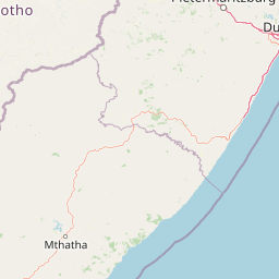
Map view of Ntsikeni Nature Reserve

Use this park location map to pinpoint Ntsikeni Nature Reserve in South Africa, understand its exact geographic position, and read its mapped placement within the surrounding landscape more clearly.

Pigeon | © OpenStreetMap contributors

Location context for Ntsikeni Nature Reserve

KwaZulu-Natal
Recorded earthquake history

Explore Historical Earthquake Records Near Ntsikeni Nature Reserve

Examine the catalogued history of seismic events identified within the vicinity of Ntsikeni Nature Reserve. This collection provides transparent access to recorded magnitudes and depth data, offering a grounded perspective on the seismic history of the surrounding Drakensberg foothills through the MoriAtlas geographical record.

Ntsikeni Nature Reserve Earthquake History

Catalogued events

2 events

Strongest magnitude

Magnitude 4.5

Most recent event

Nov 6, 2022

This history includes earthquakes recorded inside the park or within 50 km of its borders

Park atlas

Compare adjacent protected areas and regional wetland habitats across southern KwaZulu-Natal

Exploring Parks Near Ntsikeni Nature Reserve and Surrounding Drakensberg Landscapes

Compare Ntsikeni Nature Reserve with other protected areas and montane habitats across the surrounding Drakensberg foothills region. Evaluating these neighboring reserves provides deeper geographic context for regional highland ecosystems and wetland preservation.
Nature reserveKwaZulu-Natal
About 16 km away#1 closest

North

Coleford Nature Reserve: Protected Grasslands and Wetlands in KwaZulu-Natal

Tracing the landscape of a key Drakensberg foothill reserve

The Coleford Nature Reserve represents a critical protected area in the Southern Drakensberg, featuring threatened Drakensberg Foothill Moist Grassland. Its landscape is defined by the Ngwagwane River valley and diverse wetland systems, providing essential habitat for endangered bird species. This reserve functions as a gateway to the broader montane geography of the southwestern KwaZulu-Natal region.

Area
12.72 km²
Established
1948
IUCN
IV
Relief
Highland
Protected areaKwaZulu-Natal
25 km away#2 closest

North

uKhahlamba-Drakensberg Park: Protected Mountain Landscapes and Escarpment Geography in South Africa

Exploring the basalt cliffs and alpine plateau of KwaZulu-Natal.

uKhahlamba-Drakensberg Park encompasses an expansive protected region where the Drakensberg escarpment rises sharply from the foothills of KwaZulu-Natal. This atlas record details the park landscape, including its transition from sandstone terraces to high-altitude basalt, its extensive river gorges, and the concentration of archaeological cave sites. Use this resource to understand the geographic scale of this transboundary conservation area.

Area
2,429.13 km²
Relief
Mountain
Climate
Temperate
Access
Access unknown
A watercolor illustration featuring soft, green rolling hills in the foreground with pale, layered mountain peaks in the background, set against a plain white field.
Protected areaKwaZulu-Natal
25 km away#3 closest

Northwest

Maloti-Drakensberg Park Geography: Mountain Escarpments and Alpine Plateau Exploration

A transboundary protected landscape spanning South Africa and Lesotho

Spanning the core of the Drakensberg mountain system, Maloti-Drakensberg Park provides a unique window into high-altitude biodiversity and geological drama. The protected area features basalt cliffs, rolling valleys, and an extensive plateau, forming a critical ecological and cultural corridor. This atlas entry covers the topographic features and spatial distribution of one of southern Africa's most significant protected landscapes.

Area
2,493.13 km²
Established
2001
Relief
Mountain
Climate
Alpine
National parkQacha's Nek District
30 km away#4 closest

Northwest

Sehlabathebe National Park: Mapped Protected Landscape in Lesotho's Maloti Mountains

Explore high-altitude terrain, waterfalls, and ancient rock art sites.

Sehlabathebe National Park stands as a protected national park within the rugged Maloti Mountains of Lesotho's Qacha's Nek District. This destination is vital for understanding the geographic context of protected areas, featuring dramatic cliffs, iconic waterfalls like Tsoelikana, and numerous rock art sites that speak to its cultural and historical significance. Its high-altitude Afro-Alpine and sub-alpine ecosystems offer unique landscape characteristics and support notable biodiversity, making it a key point of interest for atlas-driven exploration of natural and protected terrains.

Area
69.5 km²
Established
1969
IUCN
IV
Relief
Mountain
Nature reserveKwaZulu-Natal
About 31 km away#5 closest

South

Mount Currie Nature Reserve: A Detailed Geographic Atlas of KwaZulu-Natal Mountains

High-altitude wetlands and protected Drakensberg foothills

Mount Currie Nature Reserve encompasses a rugged expanse of Drakensberg foothills characterized by sharp dolerite cliffs and expansive central wetland systems. This protected area acts as a crucial ecological intersection, bridging montane grassland and Afromontane forest patches while providing a sanctuary for diverse avian life and significant cultural heritage sites.

Area
17.77 km²
Established
1980
IUCN
IV
Relief
Mountain
Nature reserveKwaZulu-Natal
About 66 km away#6 closest

Northeast

Impendle Nature Reserve: Protecting Endangered Grasslands and Mistbelt Ecosystems

A highland conservation sanctuary in the KwaZulu-Natal region

Located in the mist-prone foothills of the Drakensberg, Impendle Nature Reserve stands as a critical block of surviving Midlands Mistbelt Grassland. The reserve terrain combines rugged dolerite ridges with moisture-rich seepage zones and wetlands, providing a specialized habitat for threatened bird species. This protected area remains a significant site for regional biodiversity, emphasizing scientific conservation over expansive development within the KwaZulu-Natal landscape.

Area
30.46 km²
Established
1983
IUCN
IV
Relief
Upland
National parkEastern Cape
101 km away#7 closest

Southwest

Grassland National Park National Park: Exploring Protected Landscapes and Regional Geography

Mapped boundaries and natural terrain context for an Eastern Cape protected area.

Grassland National Park represents a crucial protected area within South Africa's Eastern Cape province. As a national park, it offers significant insights into the region's natural landscapes and geographic character. This atlas perspective focuses on understanding the park's mapped scope, its terrain features, and its place within the broader provincial geography. Discover the unique protected landscape identity of Grassland National Park and how it contributes to the mapped natural heritage of the Eastern Cape.

Area
102.25 km²
Established
2025
IUCN
II
Relief
Mountain
Nature reserveKwaZulu-Natal
About 109 km away#8 closest

Southeast

Umtamvuna Nature Reserve: Geographic Atlas of the South African Coastal Sandstone Gorges

Protected riverine terrain in the KwaZulu-Natal province

Located along the Mtamvuna River in KwaZulu-Natal, this protected area features steep sandstone cliffs and extensive river frontage. The landscape provides a critical intersection between coastal scarp forest and plateau grasslands, offering a rich study in localized topography and endemic plant environments.

Area
32.57 km²
Established
1971
Relief
Upland
Climate
Subtropical

Common questions about visiting, size, designation, and location context for Ntsikeni Nature Reserve

Ntsikeni Nature Reserve FAQs for park facts, access, geography, and protected area context

Find quick answers about Ntsikeni Nature Reserve, including protected-area facts, park geography, trail and visitor context, and how the park fits into its surrounding country and regional landscape.
MoriAtlas Explorer

Continue Your Protected Areas Search Across the Global Atlas

Deepen your exploration by continuing the structured search for national parks and protected areas worldwide. Utilize the comprehensive filtering capabilities to compare different conservation landscapes and refine your understanding of global park geography. Discover more about the distribution and characteristics of protected natural areas.

Global natural geography