
Mori Atlas logo
Nature reserveNaturschutzgebiet Oberes Oelbachtal

Mapping the reedbeds, floodplains, and ecological connectivity of this urban nature reserve

Naturschutzgebiet Oberes Oelbachtal: A Protected Stream Valley Landscape in North Rhine-Westphalia

Naturschutzgebiet Oberes Oelbachtal preserves a critical stream valley ecosystem situated between Bochum and Dortmund in North Rhine-Westphalia. The area features extensive reedbeds, deciduous woodland, and riparian seepage streams along the Harpener Bach that provide a refuge for wetland species. By tracing the boundaries of this protected landscape, observers can understand its role in maintaining biodiversity within the densely developed Rhine-Ruhr metropolitan region.

urban nature reservestream valleyreedbedswetlandtall herb floodplaindeciduous woodland
A colorful digital illustration showing a river valley flanked by steep pink and purple cliffs, with dark green pine trees in the foreground and a waterfall in the distance.

Naturschutzgebiet Oberes Oelbachtal

Nature reserve

Park overview

Structured park overview, official facts, and landscape profile for Oberes Oelbachtal Nature Reserve

Oberes Oelbachtal Nature Reserve park facts, protected area profile, and essential visitor context

Review the core facts for Oberes Oelbachtal Nature Reserve, including designation, size, terrain, visitor scale, habitats, and operating context in one park-focused overview.

About Oberes Oelbachtal Nature Reserve

Oberes Oelbachtal is one of several small but ecologically focused nature reserves designated within the city of Bochum, in Germany's densely populated Ruhr region. Although it covers only about 37 hectares, the reserve plays an outsized role as a refuge for wetland habitats and breeding bird communities that have largely disappeared from the surrounding agricultural and urban matrix. It sits at the interface between Bochum and Dortmund, and functionally links with the larger Oelbachtal reserve across the city line, so the two areas together form a coherent stream-valley ecosystem rather than an isolated patch.

The protected landscape is shaped by the Harpener Bach (also known locally as the Bövinghauser Bach or Ölbach), which flows in a generally shallow valley with reed-dominated wetland flats and adjacent deciduous woodland. The reserve is encircled by landscape protection areas that remain in agricultural use, creating a sharp but ecologically important contrast between intensively farmed land and the protected wet valley core. This juxtaposition also makes the area a popular local recreation destination, with implications for visitor pressure and wildlife management that the reserve's protection status is designed to address.

Beyond conservation, Oberes Oelbachtal is a notable example of how small municipal nature reserves in North Rhine-Westphalia contribute to regional biodiversity strategies. Its formal designation within the broader system of Bochum nature reserves, and its connection to the Dortmund protected-area network, give it both local identity and a wider role within the Ruhr region's ecological infrastructure.

Quick facts and research context for Oberes Oelbachtal Nature Reserve

The reserve lies in the northeastern outskirts of Bochum and adjoins the Dortmund Oelbachtal reserve across the city border. Its protected area covers roughly 37 hectares and is organised around the Harpener Bach and its tributary seepage valleys.

Surrounding areas are designated as landscape protection zones that remain in agricultural use, putting noticeable recreational pressure on the small core reserve. A 2007 biodiversity survey of the entire Bövinghauser stream valley documented 787 plant, animal, and fungal species over a 24-hour period, including 33 species listed as threatened in North Rhine-Westphalia.

Protection and recognition

Review documented terrestrial protection metrics and official conservation designations

Naturschutzgebiet Oberes Oelbachtal Protection Status and Regional Conservation Scope

Terrestrial protection status and management scope for Naturschutzgebiet Oberes Oelbachtal outline official conservation boundaries. Documented records provide verified administrative details without external international recognition sources.

Protection details

Protection scope
Terrestrial
Transboundary protection
No
Park context

Deeper park guide and search-rich context for Oberes Oelbachtal Nature Reserve

Oberes Oelbachtal Nature Reserve history, landscape, wildlife, and travel context

Explore Oberes Oelbachtal Nature Reserve through its history, landscape character, ecosystems, wildlife, conservation priorities, cultural context, and seasonal travel timing in a structured park guide built for atlas discovery and search intent.

Why Oberes Oelbachtal Nature Reserve stands out

Oberes Oelbachtal is best known for its extensive reedbeds and tall-herb floodplain margins along a small urban stream, which together form a regionally significant breeding ground for wetland and ground-nesting birds. It also illustrates how a small, formally protected valley can maintain meaningful biodiversity within a heavily urbanised Ruhr-area setting.
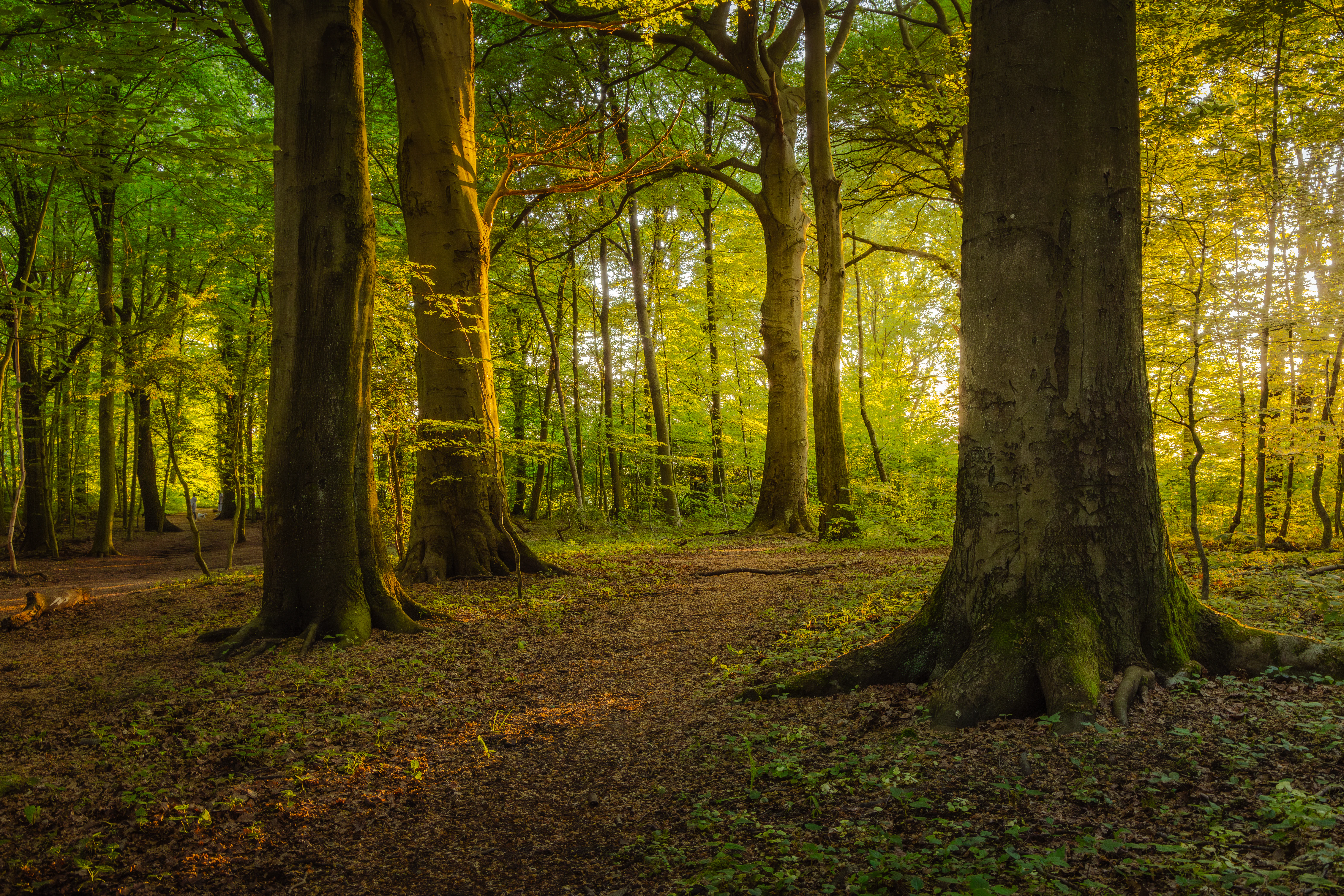
A forest interior scene showing large tree trunks in the foreground with sunlight shining through the green canopy in the background.
Sunlight filtering through large trees in the Oberes Oelbachtal nature reserve.

Oberes Oelbachtal Nature Reserve history and protected-area timeline

The reserve was formally designated as a Naturschutzgebiet (nature reserve) under the North Rhine-Westphalian system of protected areas. Its designation code, BO-004, places it among the established municipal nature reserves of Bochum. The scientific and planning groundwork for the area was laid through a series of university studies beginning in the early 1980s, including vegetational surveys of protected biotopes in the Bochum area and a specific landscape-management study of the upper Oelbachtal published in 1983.

In 1991, a care-and-development plan was prepared for the broader Oelbachtal area on the Dortmund side, reflecting the cross-boundary nature of the valley. By 2010, a comprehensive inventory of flora, vegetation, and breeding birds across the Bövinghauser stream valley, including the Bochum reserve, was published by the Bochum Botanical Society, providing a modern baseline for ongoing conservation management and visitor pressure mitigation. Renaturation plans for parts of the heavily channeled Harpener Bach have also been developed, signalling continued investment in restoring the valley's hydrological and ecological integrity.

Oberes Oelbachtal Nature Reserve landscape and geographic character

The reserve occupies a shallow, narrow stream valley in the gently undulating terrain north of central Bochum. The valley floor is dominated by the Harpener Bach, which has historically been constrained in concrete half-shells in sections, while its smaller tributary seepage streams (Siepen) enter the main course in varying conditions ranging from near-natural to straightened, piped, or otherwise modified.

In the south of the reserve, in an area known as the Berghofer Holz, lies a small permanent pond referred to locally as the Badeteich (swimming pond). Although the name reflects its earlier recreational use, the pond is now closed to bathing and is valued primarily as a standing-water habitat within the woodlands. The wider topography is modest in relief but ecologically expressive, with the valley's wet bottomlands sharply framed by surrounding agricultural slopes that sit within the broader landscape protection zone.

Oberes Oelbachtal Nature Reserve ecosystems, habitats, and plant life

Ecologically, Oberes Oelbachtal is defined by the contrast between wet valley habitats and the drier, farmed uplands around them. The core biotopes are extensive reedbeds (Schilfröhrichte) and tall-herb floodplain margins along the stream, backed by deciduous woodland on the valley slopes. Small, artificially created temporary still-water features supplement the natural hydrology, providing additional breeding and feeding conditions for moisture-dependent species.

The valley's combination of open water, reed marsh, tall herbs, and deciduous forest creates a layered habitat mosaic within a very small area. The 2007 cross-boundary biodiversity survey recorded 787 plant, animal, and fungal species in 24 hours, including 33 species on the North Rhine-Westphalian Red List, indicating that even at this small spatial scale the reserve retains a species-rich and ecologically valuable community.

Oberes Oelbachtal Nature Reserve wildlife and species highlights

The reserve's wildlife value is strongly oriented toward breeding birds, particularly ground-nesting species that depend on the open reed and tall-herb structures along the stream. The wetland margins are the most important zone, while the deciduous woodlands and the permanent Badeteich pond add habitat for amphibians, waterfowl, and woodland bird species. Free-roaming dogs from visitors are explicitly identified as a disturbance factor affecting ground-nesting birds in the valley, shaping how the reserve is managed.

Beyond birds, the 2007 survey documented a wide range of plant, animal, and fungal taxa across the broader Bövinghauser stream valley, illustrating that the reserve functions as a refugium for multiple groups of moisture- and woodland-dependent species. The presence of 33 Red List species across the survey window underscores that the area retains meaningful conservation relevance for rare and threatened taxa at the regional scale.

Oberes Oelbachtal Nature Reserve conservation status and protection priorities

As a formally designated Naturschutzgebiet within the North Rhine-Westphalian protected-area system, Oberes Oelbachtal is legally shielded against damaging interventions, and its designation as BO-004 anchors it within Bochum's municipal conservation network. Its conservation significance lies in preserving a working example of a wet stream-valley ecosystem in an otherwise intensively used Ruhr-area landscape, including connectivity with the adjacent Dortmund Oelbachtal reserve.

Active management is a central part of the reserve's role. Renaturation plans exist to replace sections of concrete channel along the Harpener Bach with more natural stream profiles, addressing decades of artificial channelisation. The reserve also experiences unusually high visitor pressure for its size, leading to concerted efforts to minimise disturbance to ground-nesting birds, including restrictions on bathing in the historical Badeteich pond. These measures reflect an ongoing balance between biodiversity protection and the reserve's role as a popular urban-adjacent recreation area.

Oberes Oelbachtal Nature Reserve cultural meaning and human context

The reserve carries a distinctly local identity shaped by its position between two large Ruhr-area cities. Names such as Bövinghauser Bachtal and Ölbach reflect long-standing regional usage and rural heritage that predates the dense urban development of surrounding districts like Gerthe and Kirchharpen. The historical name Badeteich for the woodland pond recalls an earlier era when such small water bodies were used informally for recreation, a use that has since been discontinued to protect waterbirds.

For Bochum and Dortmund residents, the valley functions as a familiar local landscape for walking and informal recreation, embedded in everyday urban life. While not a site of major built heritage or indigenous cultural significance, its value as a shared natural space in a heavily urbanised region gives it a quiet but meaningful cultural role within the surrounding communities.

Top sights and standout views in Oberes Oelbachtal Nature Reserve

The reserve's standout features are its extensive reedbeds and tall-herb floodplain along the Harpener Bach, its connectivity with the Dortmund Oelbachtal reserve across the city boundary, and the documented richness of 787 species (including 33 Red List species) recorded in a single 24-hour survey of the broader stream valley. The presence of woodland, temporary pools, and the permanent Badeteich pond adds further habitat diversity within a compact footprint.

Best time to visit Oberes Oelbachtal Nature Reserve

As a primarily wetland and woodland reserve with breeding bird interest, the most rewarding period tends to align with the spring and early summer season, when reedbeds and ground-nesting birds are most active and vegetation is at its fullest. Autumn can also be pleasant for general walking through the deciduous woodland parts of the valley, while winter generally offers a quieter experience with reduced bird activity.

Because the reserve experiences heavy visitor pressure from the surrounding Bochum and Dortmund neighbourhoods, visiting during quieter weekday hours or in cooler seasons can enhance both the visitor experience and reduce disturbance to ground-nesting birds in the sensitive valley core.

Monthly climate preview

Long-term representative monthly averages for temperature and precipitation distribution

Naturschutzgebiet Oberes Oelbachtal Climate Normals and Annual Temperature Rhythm

Representative coordinates record measured monthly temperature progression alongside steady precipitation rates across the landscape. Examining the full twelve-month profile reveals detailed baseline climate normals for Naturschutzgebiet Oberes Oelbachtal.
Annual mean9 °C
1 °C19 °C
Jan
Feb
Mar
Apr
May13°
Jun16°
Jul19°
Aug18°
Sep14°
Oct10°
Nov
Dec
Warmest month
July

18.5 °C

Coolest month
January

0.9 °C

Wettest month
December

3 mm/day

Driest month
April

1.7 mm/day

Park location guide

Geography guide, regional context, and park location map for Oberes Oelbachtal Nature Reserve

Oberes Oelbachtal Nature Reserve park geography, regions, and map view in Germany

Understand where Oberes Oelbachtal Nature Reserve sits in Germany through a broader geographic reading of the surrounding landscape, nearby location context, and its mapped position within the national park landscape.

How Oberes Oelbachtal Nature Reserve fits into Germany

Germany is a federal republic in Western and Central Europe with a population of over 83 million across sixteen constituent states. It is Europe's largest economy by nominal GDP and a major global exporter and importer. The capital is Berlin, and the country borders Denmark, Poland, Czech Republic, Austria, Switzerland, France, Luxembourg, Belgium, and the Netherlands.

Wider geography shaping Oberes Oelbachtal Nature Reserve in Germany

Germany is located in Western and Central Europe, spanning 357,022 km². It borders Denmark to the north, Poland and the Czech Republic to the east, Austria and Switzerland to the south, and France, Luxembourg, Belgium, and the Netherlands to the west. The country has coastlines on the Baltic Sea and North Sea to the north, with the Alps located in the southern region.

Map view of Oberes Oelbachtal Nature Reserve

Use this park location map to pinpoint Oberes Oelbachtal Nature Reserve in Germany, understand its exact geographic position, and read its mapped placement within the surrounding landscape more clearly.

Pigeon | © OpenStreetMap contributors

Location context for Oberes Oelbachtal Nature Reserve

North Rhine-Westphalia

Visualizing stream valley habitats, reedbeds, and protected terrain

Naturschutzgebiet Oberes Oelbachtal Photos and Landscape Scenery

Visual records reveal the diverse protected landscape features of Naturschutzgebiet Oberes Oelbachtal, from broad floodplain reedbeds to deciduous woodlands. Examining these field photographs helps researchers understand habitat structure and wetland ecology across the stream valley.

A forest interior scene showing large tree trunks in the foreground with sunlight shining through the green canopy in the background.

Park atlas

Discover connected stream valleys, urban nature reserves, and regional protected landscapes

Explore Parks Near Naturschutzgebiet Oberes Oelbachtal And Surrounding Protected Areas

Compare Naturschutzgebiet Oberes Oelbachtal with other protected areas across the surrounding regional terrain and stream-valley network. Examining adjacent nature reserves provides deeper geographic context into urban biodiversity and localized wetland conservation.
A watercolor-style illustration showing a purple stream winding through a forest floor with green vegetation, tree trunks and exposed roots on the left, and soft pink and yellow light in the background.
Nature reserveNordrhein-Westfalen
About 0.2 km away#1 closest

Northeast

Naturschutzgebiet Oelbachtal: Geography and Protected Area Context in North Rhine-Westphalia

A dense mosaic of stream-side wetlands and woodland habitats

Naturschutzgebiet Oelbachtal sits as a critical nature reserve along the border of Dortmund and Bochum. This 21.8-hectare protected area showcases a complex stream-valley topography, characterized by alternating wet meadows, hedgerows, and pond systems that support high habitat diversity in a compact, historically significant corridor.

Area
0.218 km²
Established
1986
IUCN
IV
A watercolor painting showing a soft landscape with a stream winding through green meadows toward distant hills, framed by trees on the left.
Nature reserveNordrhein-Westfalen
About 17 km away#2 closest

South

Naturschutzgebiet Oberes Sprockhöveler Bachtal: Protected Valley and Stream Geography

A nature reserve in the Ruhr foothills of Nordrhein-Westfalen

Examine the mapped boundaries and natural terrain of Naturschutzgebiet Oberes Sprockhöveler Bachtal, a compact reserve featuring a near-natural lowland brook. This habitat supports wet grassland, alder-willow galleries, and beech forest slopes that together form a protected ecological unit within the regional landscape of Nordrhein-Westfalen.

Area
0.158 km²
Established
1995
IUCN
IV
A watercolor painting of a rolling green countryside with gentle hills, clusters of trees, and a soft, hazy horizon under a pale, warm sky.
Protected landscapeNorth Rhine-Westphalia
About 23 km away#3 closest

Southeast

Landschaftsschutzgebiet Berchumer Heide, Reher Heide Protected Area and Landscape Profile

Regional landscape protection zone in North Rhine-Westphalia

Explore the structured geography of Landschaftsschutzgebiet Berchumer Heide, Reher Heide, a diverse protected area in Hagen. The landscape features a distinct contrast between dense forest ravines, small woodland pools, and open agricultural meadows, serving as a vital ecological corridor connected to adjacent nature reserves.

Area
6.227 km²
Established
1994
Relief
Upland
Water
Minor water
A horizontal watercolor illustration depicting rolling green hills, patches of forest, and distant purple-hued slopes under a pale sky.
Protected landscapeGermany
About 24 km away#4 closest

Southeast

Landschaftsschutzgebiet Eilper Berg/Langenberg: Mapped Protected Landscape in North Rhine-Westphalia

A vital green corridor of forest ridges and stream valleys

Landschaftsschutzgebiet Eilper Berg/Langenberg serves as a crucial ecological link near Hagen, Germany. This protected landscape features a rugged mosaic of ridge-and-valley terrain, supporting diverse bird species and historic cultural sites like the Wallburg Ambrock, while maintaining a green connection into the rural landscape.

Area
7.543 km²
Established
1994
Relief
Upland
Scope
Terrestrial
Protected landscapeNordrhein-Westfalen
About 25 km away#5 closest

Southeast

Landschaftsschutzgebiet Egge: Exploring the Karst Geography and Forested Hills of Hagen

A structured overview of protected terrain and regional landscape boundaries

Landschaftsschutzgebiet Egge encompasses an extensive system of wooded hills, including the Egge, Piepenbrink, and Franzosenschanze summits. This protected area offers a look at unusual geomorphological features, such as limestone-formed dry valleys and swallow holes, serving as a vital natural asset within the urban landscape of Nordrhein-Westfalen.

Area
5.397 km²
Established
1994
Relief
Upland
Climate
Temperate
A watercolor painting showing a wide, panoramic landscape of a gently curving path or stream, green forests, and soft rolling hills in the background, with wildflowers in the foreground.
Nature reserveNordrhein-Westfalen
About 25 km away#6 closest

West

Schönebecker Schlucht: Protected Stream Valleys and Geographic Map in Nordrhein-Westfalen

A rare urban nature reserve with diverse floodplain ecosystems.

Schönebecker Schlucht sits as a compact, protected landscape within the Ruhr region. The area features converging stream valleys and near-natural alder woodland that contrast with the surrounding urban geography. Examine the mapping of these steep-sided ravines, the riparian corridors, and the ecological significance of this protected habitat fragment in the state of Nordrhein-Westfalen.

Area
0.093 km²
Established
1989
IUCN
IV
Relief
Lowland
A soft, minimalist watercolor painting showing rolling green hills, a small grouping of trees, and muted yellow and pink ground tones against a white background.
Protected landscapeNordrhein-Westfalen
About 26 km away#7 closest

Southeast

Landschaftsschutzgebiet Asmecker Bachtal: A Protected Woodland Mosaic in North Rhine-Westphalia

Mapped stream valley, forest corridors, and heritage sites near Hagen

Landschaftsschutzgebiet Asmecker Bachtal protects a significant 569-hectare tract defined by its namesake stream valley and mature forest communities. This area acts as a vital landscape buffer between urban Hagen and regional transport infrastructure, preserving a mix of valley woodlands, historic agricultural sites, and a former quarry that anchors the local topography.

Area
5.693 km²
Established
1994
IUCN
V
A soft watercolor painting of a valley scene featuring green hills in the distance, marshy vegetation, and a winding stream, rendered in light pink and green tones on a white background.
Nature reserveNordrhein-Westfalen
About 27 km away#8 closest

West

Hexbachtal Nature Reserve: Geography and Protected Landscape Analysis in Nordrhein-Westfalen

Essential green corridor and floodplain forest network

Hexbachtal serves as a crucial protected area and green corridor within the highly urbanized Ruhr region of Germany. The site features a diverse range of habitats including wet meadows, ancient floodplain forests, and a meandering stream system. Beyond its ecological function, the valley is recognized as a landmark of regional planning and successful landscape conservation, illustrating the interaction between natural floodplains and metropolitan growth.

Area
0.042 km²
Established
2005
IUCN
IV
Relief
Upland

Common questions about visiting, size, designation, and location context for Oberes Oelbachtal Nature Reserve

Oberes Oelbachtal Nature Reserve FAQs for park facts, access, geography, and protected area context

Find quick answers about Oberes Oelbachtal Nature Reserve, including protected-area facts, park geography, trail and visitor context, and how the park fits into its surrounding country and regional landscape.
MoriAtlas Explorer

Continue Your Protected Areas Search Across the Global Atlas

Deepen your exploration by continuing the structured search for national parks and protected areas worldwide. Utilize the comprehensive filtering capabilities to compare different conservation landscapes and refine your understanding of global park geography. Discover more about the distribution and characteristics of protected natural areas.

Global natural geography