Mori Atlas logo
Nature reserveOberwiesen von Sprendlingen

Mapping the ecological mosaic of wet meadows, fen fragments, and woodland edges

Oberwiesen von Sprendlingen Nature Reserve: Protected Grassland Geography in Hessen

(Naturschutzgebiet Oberwiesen von Sprendlingen)

Oberwiesen von Sprendlingen serves as a vital nature reserve within the Hessen region, situated in the transitional zone between the Untermainebene and the Messeler Hügelland. This site features a dense mosaic of extensively managed wet meadows, calcareous fen patches, and orchard meadow margins. The area remains a key example of preserved cultural grassland heritage, providing critical habitat within the broader Rhine-Main landscape context.

wet meadowscalcareous fenseminatural grasslandnature reserveorchard meadowreed beds

Oberwiesen von Sprendlingen

Nature reserve

Park overview

Structured park overview, official facts, and landscape profile for Oberwiesen von Sprendlingen

Oberwiesen von Sprendlingen park facts, protected area profile, and essential visitor context

Review the core facts for Oberwiesen von Sprendlingen, including designation, size, terrain, visitor scale, habitats, and operating context in one park-focused overview.

About Oberwiesen von Sprendlingen

Oberwiesen von Sprendlingen is one of many small but carefully managed nature reserves that together form the backbone of ecological conservation in the densely populated Rhine-Main region of Germany. Located in the Hessian Landkreis Offenbach and administratively within the city of Dreieich, the reserve guards a fragment of the traditional meadow and fen landscape that once characterized the transition between the Lower Main plain and the rolling Messeler Hügelland. Though only about seventeen hectares in extent, it preserves a remarkably diverse set of habitat types.

The protected area comprises predominantly wet meadows maintained through extensive agricultural use, an unusual fragment of calcareous fen, drier grassland communities, and adjoining woodland areas. A marginal strip of traditional orchard meadow (Streuobstwiese) further enriches the structural diversity. Because of this combination, the reserve functions as a refuge for plant communities, insects, and bird species that depend on open, lightly disturbed cultural landscapes rather than on either intensively farmed land or dense forest.

The reserve was formally designated as a Naturschutzgebiet in 1996, drawing on a body of scientific work that had documented the area's floristic and ecological significance since the 1970s. Management is the responsibility of the local nature protection authority, and the site is explicitly intended to be connected ecologically with the neighboring Herrnröther- und Bornwaldswiesen von Sprendlingen, creating a larger functioning complex of protected meadow habitats in the Dreieich area.

Quick facts and research context for Oberwiesen von Sprendlingen

Oberwiesen von Sprendlingen is a nature reserve in the Landkreis Offenbach in southern Hesse, within the municipal area of Dreieich. The site covers approximately seventeen hectares and lies east of the Sprendlingen district.

It is classified by the World Database on Protected Areas as IUCN Category IV (Habitat/Species Management Area) under the identifier 164906, and carries the German NSG designation 1438026. The reserve was officially designated in 1996 and is administered by the lower nature protection authority (Untere Naturschutzbehörde) of Landkreis Offenbach.

Protection and recognition

Examine the verified conservation scope, management data, and formal recognition records.

Oberwiesen von Sprendlingen Protection Status and Designated Terrestrial Scope

Oberwiesen von Sprendlingen holds a documented terrestrial protection status within the global protected area network. Review the verified designation details, management context, and international recognition records compiled for this site.

Protection details

Protection scope
Terrestrial
Transboundary protection
No
WDPA ID
164906
Park context

Deeper park guide and search-rich context for Oberwiesen von Sprendlingen

Oberwiesen von Sprendlingen history, landscape, wildlife, and travel context

Explore Oberwiesen von Sprendlingen through its history, landscape character, ecosystems, wildlife, conservation priorities, cultural context, and seasonal travel timing in a structured park guide built for atlas discovery and search intent.

Why Oberwiesen von Sprendlingen stands out

Oberwiesen von Sprendlingen is best known for its concentration of rare seminatural meadow communities within a very small area, particularly wet meadows with marsh ragwort (Wassergreiskraut) and purple moor-grass (Pfeifengras) societies, together with fragments of calcareous fen and surrounding woodland edge habitats. These features, combined with the presence of characteristic meadow birds, make it a compact showcase of the cultural grassland heritage of the Untermainebene and the Messeler Hügelland. The reserve is also noted for the scientific attention it has received: its conservation value has been evaluated through geobotanical and ecological studies dating back to the 1970s, culminating in a detailed protection assessment commissioned by the regional nature authority in 1993. This long history of documentation gives the site an unusually well-documented ecological profile for an area of its size.
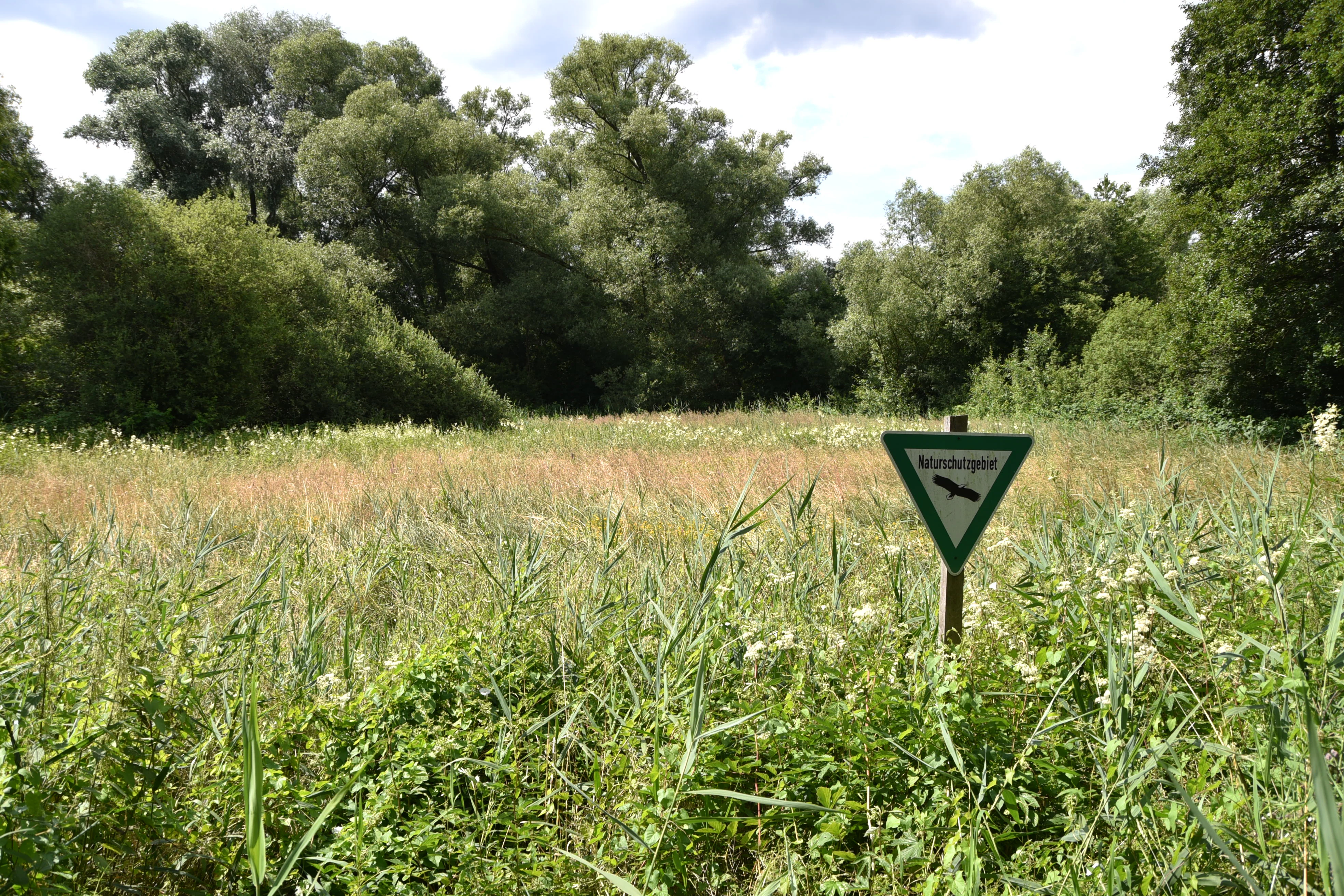
A triangular green and white nature reserve sign on a wooden post in front of a field of tall grass and trees.
A nature reserve sign marking the Oberwiesen von Sprendlingen area.

Oberwiesen von Sprendlingen history and protected-area timeline

The ecological importance of the meadows around Sprendlingen attracted scientific attention decades before the area received formal protection. Geobotanical and conservation assessments were carried out from the 1970s onward, including an unpublished statement from the Technical University of Darmstadt in 1985 regarding the planning of what was then anticipated as the protected area "Westliche Oberwiesen von Sprendlingen," and an earlier broader conservational review by Ernst covering the period 1975 to 1982.

In 1993, the higher nature protection authority (obere Naturschutzbehörde) commissioned a detailed assessment of the area's conservation value. This study highlighted the distinctive botanical and ecological character of the meadows and provided the scientific foundation for formal protection. As a result, Oberwiesen von Sprendlingen was officially designated as a Naturschutzgebiet in 1996, and has since been managed as part of the network of protected sites in Landkreis Offenbach, with the explicit aim of building ecological connections with the adjacent Herrnröther- and Bornwaldswiesen.

Oberwiesen von Sprendlingen landscape and geographic character

The reserve sits in a transitional landscape where the flat agricultural lowlands of the Untermainebene meet the gently undulating Messeler Hügelland. This setting produces subtle but important variations in soil moisture and chemistry within a very compact area. Small differences in elevation and water table support parallel sequences of wetter and drier habitats side by side.

Topographically, the area consists of open meadow ground rather than dramatic relief. Most of the visible landscape is given over to expansive grassland, with reed beds and patches of tall herbs in the lower-lying wetter sections, short sedge and fen vegetation in the calcareous fen fragments, and woodland edging the reserve at its margins. A traditional orchard meadow fringe adds height and structure to the overall mosaic. The result is a patchwork of open, semi-open, and lightly wooded terrain rather than a single dominant landform.

Oberwiesen von Sprendlingen ecosystems, habitats, and plant life

Ecologically, Oberwiesen von Sprendlingen is defined by its seminatural grassland vegetation. The central habitat type consists of wet meadows dominated by marsh ragwort and purple moor-grass societies, which are maintained through extensive mowing and grazing rather than through abandonment or intensification. These wet meadows are ecologically significant because they depend on low-intensity continued human management to retain their characteristic species composition.

Within this wet meadow matrix, the reserve also protects fragments of calcareous fen, a habitat type of considerable botanical value in central Europe and one that has become increasingly rare in the Rhine-Main area. Alongside the wet habitats, drier, species-rich grassland and tall herb communities occur, as do reed stands and patches of alder-willow scrub. Marginal orchard meadow, woodland edge, and shrub transitions create structural variety and support the more mobile elements of the local fauna.

Oberwiesen von Sprendlingen wildlife and species highlights

The reserve's fauna is closely tied to its open, mosaic character. Typical breeding birds of cultural meadows and drier edges documented in the area include red-backed shrike (Neuntöter), European stonechat (Schwarzkehlchen), common nightingale (Nachtigall), and common redstart (Gartenrotschwanz); these species favor the combination of scrub, hedges, and open ground that the reserve provides.

Historically, the site also supported lapwing (Kiebitz) and common snipe (Bekassine), which were characteristic of wet meadow habitats but whose local presence has been lost over time. Conservation planners have explored the possibility of re-establishing these species in the reserve, although these efforts had not, at the time of the source, succeeded in restoring breeding populations. The wider invertebrate fauna, though not detailed in the available material, would be expected to be rich given the diversity of flowering plants, the presence of traditional orchard trees, and the long continuity of low-intensity grassland management.

Oberwiesen von Sprendlingen conservation status and protection priorities

The conservation purpose of Oberwiesen von Sprendlingen is to preserve and develop a complex of closely interdependent seminatural habitats: wet meadows, dry grassland, fen fragments, sedge swards, tall herb stands, reed beds, and alder-willow scrub. Together, these communities support numerous threatened plant and animal associations, and the protected status is intended to buffer them from the pressures of urbanization, agricultural intensification, and abandonment that affect the surrounding Rhine-Main lowlands.

A key aim of the designation is ecological connectivity: the reserve is meant to be linked with the ecologically similar, nearby Herrnröther- und Bornwaldswiesen von Sprendlingen in order to form a larger functional network of meadow habitats. The site's conservation value is unusual in being supported by a long-standing scientific documentation effort, beginning with academic geobotanical assessments in the 1970s, followed by a formal statutory protection assessment in 1993 and final designation in 1996. This depth of underlying research gives the reserve a particularly solid scientific basis for management decisions.

Top sights and standout views in Oberwiesen von Sprendlingen

Among the reserve's standout qualities is the very high habitat diversity packed into a small footprint: wet meadows, fragments of calcareous fen, orchard meadow, woodland edges, and reed stands coexist within about seventeen hectares. This diversity is unusual even by the standards of the extensively studied Unter-main region.

Equally notable is the reserve's strong scientific documentation, stretching from 1970s geobotanical work through to its 1993 protection assessment, which makes it possible to track ecological change across decades. The reserve's role as an intended ecological bridge to the neighboring Herrnröther- und Bornwaldswiesen also gives it significance beyond its own boundaries, anchoring a larger network of protected meadow habitats within the Dreieich landscape.


Monthly climate preview

Long-term representative temperature and precipitation averages for Hessen

Oberwiesen von Sprendlingen Climate Normals and Monthly Temperature Patterns

Oberwiesen von Sprendlingen exhibits a measured annual temperature and precipitation rhythm recorded across representative park coordinates from 1991 to 2020. Reviewing the complete twelve-month climate profile reveals detailed monthly variations in baseline temperatures and precipitation rates.
Annual mean10 °C
0 °C21 °C
Jan
Feb
Mar
Apr10°
May14°
Jun18°
Jul21°
Aug20°
Sep15°
Oct10°
Nov
Dec
Warmest month
July

20.6 °C

Coolest month
January

0.2 °C

Wettest month
July

2.2 mm/day

Driest month
April

1.4 mm/day

Park location guide

Geography guide, regional context, and park location map for Oberwiesen von Sprendlingen

Oberwiesen von Sprendlingen park geography, regions, and map view in Germany

Understand where Oberwiesen von Sprendlingen sits in Germany through a broader geographic reading of the surrounding landscape, nearby location context, and its mapped position within the national park landscape.

How Oberwiesen von Sprendlingen fits into Germany

Germany is a federal republic in Western and Central Europe with a population of over 83 million across sixteen constituent states. It is Europe's largest economy by nominal GDP and a major global exporter and importer. The capital is Berlin, and the country borders Denmark, Poland, Czech Republic, Austria, Switzerland, France, Luxembourg, Belgium, and the Netherlands.

Wider geography shaping Oberwiesen von Sprendlingen in Germany

Germany is located in Western and Central Europe, spanning 357,022 km². It borders Denmark to the north, Poland and the Czech Republic to the east, Austria and Switzerland to the south, and France, Luxembourg, Belgium, and the Netherlands to the west. The country has coastlines on the Baltic Sea and North Sea to the north, with the Alps located in the southern region.

Map view of Oberwiesen von Sprendlingen

Use this park location map to pinpoint Oberwiesen von Sprendlingen in Germany, understand its exact geographic position, and read its mapped placement within the surrounding landscape more clearly.

Pigeon | © OpenStreetMap contributors

Location context for Oberwiesen von Sprendlingen

Hessen

Visualizing wet meadows, protected habitats, and regional terrain characteristics

Oberwiesen von Sprendlingen Photos and Landscape Scenery Exploration

Visual documentation reveals the intricate mosaic of wet meadows, fen fragments, and woodland edges defining the protected reserve. Photographic records provide clear insight into the botanical richness and transitional terrain characterizing the protected area.

A triangular green and white nature reserve sign on a wooden post in front of a field of tall grass and trees.

Park atlas

Compare regional nature reserves and connected grassland habitats across the surrounding terrain.

Explore Parks Near Oberwiesen von Sprendlingen and Adjacent Protected Landscapes

Browse protected areas and natural reserves located near Oberwiesen von Sprendlingen in the regional landscape. Compare adjacent meadow ecosystems and regional conservation networks to understand the broader geography.
Nature reserveHessen
About 1.5 km away#1 closest

East

Luderbachaue von Dreieich: A Protected Floodplain Forest and Habitat in Hessen, Germany

Mapping the ecological geography of a significant lowland nature reserve

Spanning over 290 hectares, Luderbachaue von Dreieich serves as a major protected floodplain forest. The site preserves a diverse mosaic of oak, beech, and alder-ash woodlands that sustain rare fungal communities and old-growth timber, maintaining a vital green corridor in the urbanized Rhine-Main region.

Area
2.938 km²
Established
1996
IUCN
IV
Relief
Lowland
Nature reserveHessen
About 4.4 km away#2 closest

Northeast

Bruch von Gravenbruch Nature Reserve: Geographic Profile and Protected Wetland Mapping

Hessen lowland moor and wetland habitat analysis

Examine the detailed terrain of Bruch von Gravenbruch, a notable nature reserve in Hessen characterized by its high groundwater table and intricate moisture-dependent ecosystems. The area serves as a key reference for studying lowland moor development, bog woodland structure, and the spatial distribution of protected wetland meadows across the regional landscape.

Area
0.932 km²
Established
1984
IUCN
IV
A horizontal watercolor painting showing a quiet pond or lake surrounded by low, green vegetation and soft, pastel skies.
Nature reserveHesse
About 4.8 km away#3 closest

Northwest

Gehspitzweiher bei Neu-Isenburg: A Protected Nature Reserve in the Rhine-Main Region of Hesse

Mapping the ecological transition of an abandoned post-industrial extraction site

Gehspitzweiher bei Neu-Isenburg stands as an important nature reserve defined by its sunken basin and diverse habitat mosaic. Located within the Alten Heegwald forest near Frankfurt, this 25-hectare area showcases the natural recovery of former quarry lands into a hotspot for dragonfly, amphibian, and bird species within the Hesse landscape.

Area
0.25 km²
Established
1981
IUCN
IV
Nature reserveHessen
About 6.7 km away#4 closest

Southwest

Kammereckswiesen und Herchwiesen von Langen: Protected Nature Reserve in Hessen, Germany

Geographic analysis of meadowland, grassland, and wetland habitat mosaic.

Kammereckswiesen und Herchwiesen von Langen serves as a significant nature reserve within the Rhine-Main area of Hessen. The site is defined by its unusual botanical diversity, derived from a close proximity of dry sandy soil and moisture-retaining clay patches. This atlas entry details the internal terrain structure, highlighting how traditional meadow management sustains rare dragonflies, butterflies, and orchids in this protected lowland landscape.

Area
28.8 km²
Established
1982
IUCN
IV
A horizontal watercolor painting depicting a landscape with calm water, grassy marshlands, and distant rolling hills in soft pastel colors.
Nature reserveHessen
About 7 km away#5 closest

East

Nachtweide von Patershausen: Nature Reserve Geography and Mapped Protected Boundaries

Protected landscape and habitat atlas for the Hessen region

Nachtweide von Patershausen stands as a vital nature reserve in Hessen, characterized by a textured cultural landscape that includes rare nutrient-poor grassland and historical carp ponds. This protected site offers significant insight into the regional ecology of the Rhine-Main area, providing a dense mosaic of habitats that anchor the local natural environment near Heusenstamm.

Area
0.178 km²
Established
1987
IUCN
IV
Watercolor painting of a green wetland landscape with trees, grasses, and distant rolling hills on a white background.
Nature reserveHessen
About 8.8 km away#6 closest

Northeast

Erlensteg von Bieber Nature Reserve: Geographic Map and Protected Habitat Overview

Compact wetland and forest mosaic in the Hessen region

Erlensteg von Bieber preserves a rare concentration of habitat types within a small footprint. From its moist floodplain meadows and sedge wetlands to its drier forest glades and fallow fields, this reserve showcases vital conservation management in the Rhine-Main area of Germany.

Area
0.752 km²
Established
1996
IUCN
IV
Nature reserveHesse
About 8.8 km away#7 closest

Southwest

Faulbruch bei Erzhausen: Protected Wetland Landscapes and Regional Nature Reserve Atlas

Mapping rare fen woodlands and wet meadow habitats in southern Hesse

This nature reserve protects an ecologically distinct combination of black alder fen, mat grass pastures, and calcareous meadows near Erzhausen. Situated on silty, peaty soils within the southern Hessian lowlands, the site serves as a vital refuge for specialized biodiversity, maintained by its unique groundwater hydrology and surrounding anthropogenic borders.

Area
0.658 km²
Established
2001
Relief
Lowland
Climate
Temperate
A watercolor painting showing a soft, bright landscape with green rolling hills, distant trees, and scattered yellow wildflowers.
Nature reserveHessen
About 9.4 km away#8 closest

South

Im Mörsbacher Grund von Darmstadt-Arheilgen: Geography and Protected Wetland Atlas

Nature reserve landscape mapping in Hessen, Germany

Explore the structured landscape of Im Mörsbacher Grund von Darmstadt-Arheilgen. This nature reserve provides essential habitat connectivity through its wet meadows, orchids, and alluvial woodlands along the Hahnwiesenbach stream, representing an important segment of the regional conservation network.

Area
0.681 km²
Established
1987
IUCN
IV
Scope
Terrestrial

Common questions about visiting, size, designation, and location context for Oberwiesen von Sprendlingen

Oberwiesen von Sprendlingen FAQs for park facts, access, geography, and protected area context

Find quick answers about Oberwiesen von Sprendlingen, including protected-area facts, park geography, trail and visitor context, and how the park fits into its surrounding country and regional landscape.
MoriAtlas Explorer

Continue Your Protected Areas Search Across the Global Atlas

Deepen your exploration by continuing the structured search for national parks and protected areas worldwide. Utilize the comprehensive filtering capabilities to compare different conservation landscapes and refine your understanding of global park geography. Discover more about the distribution and characteristics of protected natural areas.

Global natural geography