

Mori Atlas logo
Marine protected areaOceanic Shoals Marine Park

A vast tropical marine protected area featuring unique carbonate banks, pinnacles, and diverse continental shelf ecosystems.

Oceanic Shoals Marine Park: Mapping the Protected Marine Landscapes of Northern Australia

Oceanic Shoals Marine Park represents a significant protected seascape within the North Marine Parks Network, spanning vast continental shelf waters off the coast of the Northern Territory. This underwater landscape encompasses complex bathymetric features including the Van Diemen Rise, structural pinnacles, and expansive carbonate bank systems. The region provides essential habitat for migratory sea turtles and pelagic marine life, serving as a critical geographic focal point for tropical marine conservation and biodiversity research in Australian waters.

marine parktropical marinecontinental shelfcarbonate bankspinnaclesseabed features

Oceanic Shoals Marine Park

Marine protected area

Park overview

Structured park overview, official facts, and landscape profile for Oceanic Shoals Marine Park

Oceanic Shoals Marine Park park facts, protected area profile, and essential visitor context

Review the core facts for Oceanic Shoals Marine Park, including designation, size, terrain, visitor scale, habitats, and operating context in one park-focused overview.

About Oceanic Shoals Marine Park

Oceanic Shoals Marine Park is a federal marine reserve in the waters of the northern Australian continental shelf, situated offshore of the Northern Territory and the Darwin region. Although far from the shoreline, the park is part of Australia's national network of marine parks and sits within one of the most biologically productive tropical marine regions in the country. Its remote offshore setting protects large, intact tracts of seafloor that are otherwise difficult to safeguard.

The park spans distinct marine bioregions of northern Australia. It straddles parts of the Northwest Shelf Transition Province, which encompasses the Bonaparte, Oceanic Shoals, and Tiwi meso-scale bioregions, as well as the adjacent Timor Transition Province. This overlap of bioregional provinces is one of the reasons Oceanic Shoals has such a varied ecological character, because each province brings its own oceanographic and biological patterns.

Under the surface, Oceanic Shoals is defined by a remarkable seafloor topography. The Van Diemen Rise is dominated by a carbonate bank and terrace system considered a unique seabed feature of the region. The Joseph Bonaparte Gulf contains carbonate banks known for enhanced productivity and high biodiversity. The pinnacles of the Bonaparte Basin add further structural complexity, and the shelf break and slope of the Arafura Shelf shape the boundary between shallow and deeper tropical waters. These features together support diverse benthic communities and create natural hotspots for fish, invertebrates, and larger predators.

Oceanic Shoals is the largest of the eight parks managed within the North Marine Parks Network, and it plays a major role in Australia's framework for protecting tropical marine biodiversity. It was proclaimed under the Environment Protection and Biodiversity Conservation Act, originally established as a Commonwealth marine reserve, and reconstituted and renamed as the Oceanic Shoals Marine Park in 2017 before becoming actively managed in 2018. Its designation reflects both the ecological significance of the area and Australia's commitment to conserving offshore waters as part of its national marine estate.

Quick facts and research context for Oceanic Shoals Marine Park

Oceanic Shoals Marine Park is an Australian marine park located off the Northern Territory, near Darwin. It is managed by Parks Australia as part of the North Marine Parks Network and is classified in the Australian system under sustainable-use protection with embedded fully protected zones. It is the largest of the eight parks in the North Marine Parks Network.

Established under Australian federal environment law and brought under active management on 1 July 2018, the park crosses major tropical marine bioregions of northern Australia. Its conservation importance is linked to flatback, olive ridley, and loggerhead turtles, as well as manta rays, sharks, and cetaceans that use waters overlying distinctive carbonate banks and shelf-break habitats.

Protection and recognition

Documented marine protection parameters and official recognition records

Oceanic Shoals Marine Park Protection Status and Management Scope

Marine conservation boundaries define the structural parameters and management scope established for Oceanic Shoals Marine Park. Recorded protection metrics outline the designated operational framework governing this protected marine area.

Protection details

Protection scope
Marine
Transboundary protection
No
Park context

Deeper park guide and search-rich context for Oceanic Shoals Marine Park

Oceanic Shoals Marine Park history, landscape, wildlife, and travel context

Explore Oceanic Shoals Marine Park through its history, landscape character, ecosystems, wildlife, conservation priorities, cultural context, and seasonal travel timing in a structured park guide built for atlas discovery and search intent.

Why Oceanic Shoals Marine Park stands out

Oceanic Shoals is best known for the carbonate bank and terrace system of the Van Diemen Rise, a unique seafloor feature of the continental shelf. The park's carbonate banks in the Joseph Bonaparte Gulf and the pinnacles of the Bonaparte Basin are recognized for enhanced productivity and high biodiversity, while the shelf break and slope of the Arafura Shelf add further ecological contrast. The park is also strongly associated with migratory marine megafauna. Its waters are important for flatback turtles resting between egg-laying events, olive ridley turtles and loggerhead turtles foraging, and a wide range of pelagic species including manta rays and killer whales.
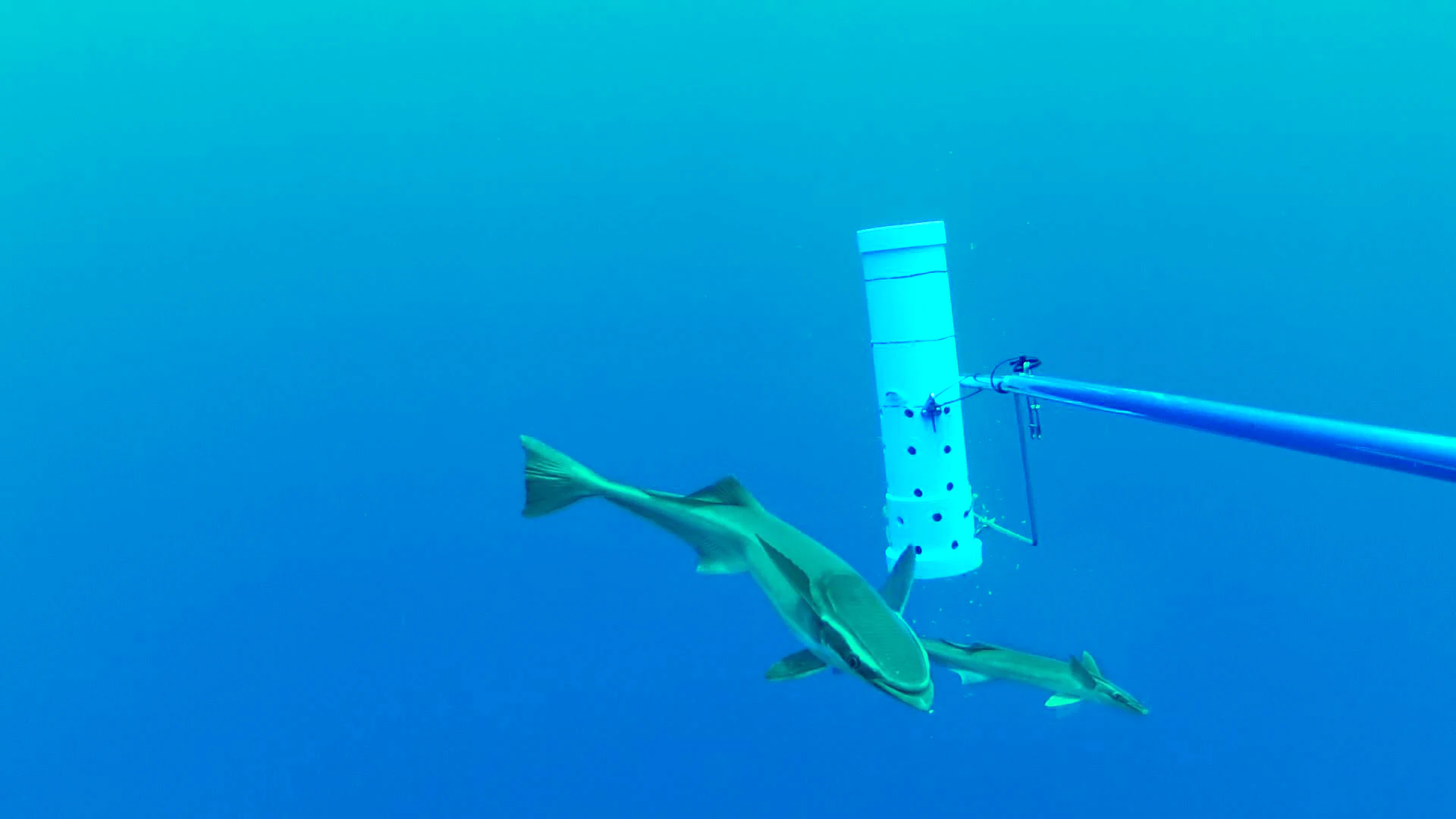
Two slender sharksuckers swimming underwater near a white cylindrical research device mounted on a pole.
Two slender sharksuckers swimming near a baited underwater camera rig in Oceanic Shoals Marine Park.

Oceanic Shoals Marine Park history and protected-area timeline

Oceanic Shoals was first proclaimed as a Commonwealth marine reserve under Australia's Environment Protection and Biodiversity Conservation Act on 14 December 2013. At that time it was known as the Oceanic Shoals Commonwealth Marine Reserve and was established as part of the broader Australian Marine Parks system designed to protect offshore biodiversity.

The reserve was reconstituted and renamed as the Oceanic Shoals Marine Park on 9 October 2017, reflecting a shift in the Australian management framework for marine parks and a reorganization of zoning and management arrangements. The park's management plan and its first set of active protection measures came into effect on 1 July 2018, when operations under the new designations began. Since then, Parks Australia has overseen ongoing management of the park as part of the North Marine Parks Network.

Oceanic Shoals Marine Park landscape and geographic character

Oceanic Shoals is essentially an underwater landscape on a vast scale. Its seafloor combines broad, relatively flat continental shelf areas with abrupt structural features that rise above the surrounding seabed. The Van Diemen Rise, in particular, is defined by a carbonte bank and terrace system that gives the area much of its character and makes it ecologically distinctive.

In the south and west of the park, the Joseph Bonaparte Gulf includes a series of carbonate banks known for their contribution to productivity and biodiversity. North of these, the pinnacles of the Bonaparte Basin add vertical structure above the surrounding seafloor, providing habitat that distinguishes this part of the shelf from more uniform sandy or muddy seabed further offshore. Together, these geological features create a varied bathymetric environment.

The eastern edge of the park is defined by the shelf break and slope of the Arafura Shelf, where the shallow tropical shelf drops into deeper waters. This transition zone is biologically important because it concentrates nutrients, supports pelagic species that move between shallow and deep water, and creates conditions for diverse assemblages of fish and invertebrates across a relatively short horizontal distance.
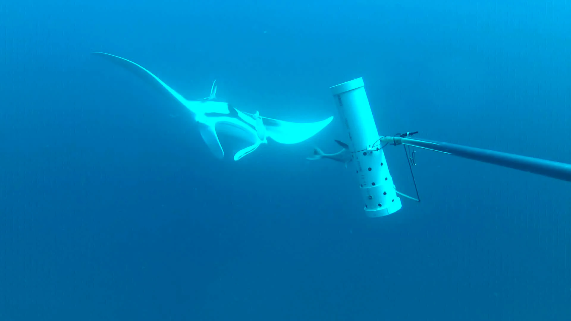
A giant manta ray swims in deep blue water near a white cylindrical research instrument attached to a pole.
A giant manta ray swims near a research monitoring device in the waters of Oceanic Shoals Marine Park.

Oceanic Shoals Marine Park ecosystems, habitats, and plant life

Oceanic Shoals crosses two major provincial bioregions, which together provide a strong basis for its ecological richness. The Northwest Shelf Transition Province includes the Bonaparte, Oceanic Shoals, and Tiwi meso-scale bioregions, each representing distinct combinations of water depth, seabed type, and oceanographic influence. The Timor Transition Province contributes additional tropical and Indo-Pacific influence, extending the park's ecological links beyond northern Australia.

The combination of carbonate banks, terraces, pinnacles, and shelf slope creates a varied habitat mosaic. Banks and pinnacles elevate benthic organisms above the surrounding sediment, increasing habitat complexity for sponges, corals, and other reef-associated species. These structured habitats in turn support fish communities, while the surrounding shallows and open shelf waters accommodate turtles, sharks, rays, and pelagic predators.

Because the area lies in tropical waters and covers such a wide breadth of shelf habitat, the park is ecologically productive throughout the year. The convergence of bathymetric structure with northern Australia's tropical oceanography makes the park a zone where enhanced biological productivity is consistently expressed, particularly in waters overlying banks, ridges, and pinnacles.

Oceanic Shoals Marine Park wildlife and species highlights

Oceanic Shoals supports a rich tropical marine fauna typical of northern Australia but enhanced by the variety of seafloor habitats it protects. The park's waters are especially important for sea turtles. Flatback turtles use the area as an internesting habitat, resting between egg-laying events, while olive ridley turtles also use the area for resting, and loggerhead turtles and olive ridley turtles use the area for foraging.

Larger pelagic species are also present in the park, with photographic observations documenting manta rays, killer whales, and slender sharksuckers that often accompany larger animals. These sightings indicate that Oceanic Shoals is part of the broader migratory routes of wide-ranging species that depend on productive tropical shelf waters.

The mix of carbonate banks, pinnacles, and shelf waters provides habitat for reef fishes and other tropical species associated with structured benthic seabed, as well as species that live over open shelf sediments. Together, the park's wildlife profile links familiar tropical reef and shelf species with migratory megafauna, giving it a distinctive combination of resident and transient fauna.

Oceanic Shoals Marine Park conservation status and protection priorities

Oceanic Shoals Marine Park has been identified as a nationally significant conservation area because of its role in protecting tropical marine biodiversity and unique seabed features on the northern Australian shelf. Its conservation value rests on the protection of carbonte bank and terrace systems, pinnacles, and shelf-break habitats that would otherwise be vulnerable to disturbance from industrial activity.

The park is assigned the IUCN sustainable-use protected-area category overall, but its internal zoning ranges from fully protected National Park zones, where fishing and extraction are excluded, through Habitat Protection zones that allow limited activity, to Multiple Use and Special Purpose zones that permit regulated commercial operations under approval. This zoning system allows for strong, no-take protection in critical habitat areas while still accommodating sustainable activity elsewhere.

Protection of the park contributes to broader conservation objectives for migratory marine species, including flatback, loggerhead, and olive ridley turtles, and supports maintenance of ecologically productive areas off the northern Australian coast. Its management under Parks Australia links it to coordinated monitoring and planning for the wider North Marine Parks Network.

Oceanic Shoals Marine Park cultural meaning and human context

The waters and seabed of the Oceanic Shoals Marine Park lie within a broader seascape historically used and traveled by coastal Aboriginal and Torres Strait Islander peoples of northern Australia. While the park itself is remote and offshore, it forms part of the seascape associated with Indigenous maritime traditions in the Northern Territory region.

In modern governance, the park is administered by the Australian Government through Parks Australia, and its management planning is integrated with broader Australian marine policy rather than with a single local community. The park's role as a national offshore conservation area is therefore primarily framed in ecological and scientific terms rather than as a place rooted in continuous everyday human settlement.

Top sights and standout views in Oceanic Shoals Marine Park

The Van Diemen Rise carbonate bank and terrace system is one of the most unusual seabed features in the region and a defining element of the park's identity. The Joseph Bonaparte Gulf carbonate banks and the pinnacles of the Bonaparte Basin add further structural richness, creating productive habitat hotspots across a vast shelf area.

The park's importance for migratory marine megafauna, especially flatback, loggerhead, and olive ridley turtles, gives it a clear ecological profile beyond its geological character. Its scale, its zoning system that includes fully protected zones, and its position within the North Marine Parks Network together make Oceanic Shoals one of the anchor protected areas of northern Australia's tropical marine estate.

Best time to visit Oceanic Shoals Marine Park

Oceanic Shoals is a remote offshore marine park in tropical waters, where conditions follow the seasonal climate patterns of northern Australia. The dry season, roughly from May to September, generally brings calmer seas, lower humidity, and reduced rainfall, which favor offshore marine fieldwork, research, and vessel-based visitation.

The wet season, from roughly November to March, brings higher rainfall, increased runoff, and stronger monsoon weather, often with rougher sea conditions. Although some species remain present year-round, sea conditions are typically more stable and predictable during the dry season, which is the most practical window for offshore activity in this part of northern Australia.

Monthly climate preview

Long-term monthly temperature cycles and precipitation patterns across the representative coordinate

Oceanic Shoals Marine Park Average Temperature and Precipitation Normals

Representative coordinate records show steady high thermal baselines alongside distinct monthly precipitation variations across the marine park area. Reviewing the complete twelve-month climatology dataset clarifies long-term regional weather patterns in greater detail.
Annual mean28 °C
26 °C29 °C
Jan29°
Feb28°
Mar28°
Apr29°
May28°
Jun27°
Jul26°
Aug26°
Sep26°
Oct28°
Nov29°
Dec29°
Warmest month
December

29 °C

Coolest month
August

25.8 °C

Wettest month
January

7.5 mm/day

Driest month
September

0.3 mm/day

Park location guide

Geography guide, regional context, and park location map for Oceanic Shoals Marine Park

Oceanic Shoals Marine Park park geography, regions, and map view in Australia

Understand where Oceanic Shoals Marine Park sits in Australia through a broader geographic reading of the surrounding landscape, nearby location context, and its mapped position within the national park landscape.

How Oceanic Shoals Marine Park fits into Australia

Australia is a constitutional monarchy and federal parliamentary democracy comprising six states and ten territories. With a population of nearly 28 million, it is one of the world's most urbanised countries, with most people concentrated on the eastern seaboard. The country has a high Human Development Index and is known for its cultural diversity, ancient Aboriginal heritage, and unique wildlife.

Wider geography shaping Oceanic Shoals Marine Park in Australia

Australia occupies the entire Australian continent, the island of Tasmania, and numerous smaller islands. It is the world's flattest and driest inhabited continent, featuring vast deserts in the interior (the Outback), tropical rainforests along the eastern coast, and a coastline bordering the Indian and Pacific Oceans.

Map view of Oceanic Shoals Marine Park

Use this park location map to pinpoint Oceanic Shoals Marine Park in Australia, understand its exact geographic position, and read its mapped placement within the surrounding landscape more clearly.

Pigeon | © OpenStreetMap contributors

Location context for Oceanic Shoals Marine Park

Northern Territory
Recorded earthquake history

Explore Historical Earthquake Records for Oceanic Shoals Marine Park

Review recorded seismic activity and historical event data associated with the waters of Oceanic Shoals Marine Park. This catalogue provides direct access to epicentre locations and magnitude metrics, facilitating a clearer understanding of seismic occurrences near this expansive Australian marine reserve through MoriAtlas data.

Oceanic Shoals Marine Park Earthquake History

Catalogued events

18 events

Strongest magnitude

Magnitude 4.8

Most recent event

Aug 18, 2025

This history includes earthquakes recorded inside the park or within 50 km of its borders

Visual exploration of remote tropical marine habitats and seafloor terrain

Oceanic Shoals Marine Park Photos and Protected Area Scenery

Visual documentation reveals the diverse submarine topography, carbonate banks, and expansive continental shelf waters that define the protected landscape. Examining protected area imagery provides clearer insight into the remote tropical habitats and geological features sustaining marine megafauna across northern Australian waters.

Two slender sharksuckers swimming underwater near a white cylindrical research device mounted on a pole.

An orca swims through deep blue water next to a submerged scientific sampling device on a pole.

A giant manta ray swims in deep blue water near a white cylindrical research instrument attached to a pole.

Park atlas

Compare regional marine reserves and protected shelf environments

Explore Other Parks Near Oceanic Shoals Marine Park and Surrounding Waters

Browse other protected areas and marine reserves situated near Oceanic Shoals Marine Park in northern Australian waters. Continuing into surrounding regional habitats reveals broader patterns across continental shelf ecosystems and tropical marine zones.
Marine protected areaWestern Australia
57 km away#1 closest

Southwest

Kimberley Marine Park: Atlas of Protected Marine Habitats and Submerged Coastal Geography

Western Australia Marine Protected Area and seafloor terrain

Spanning over 74,000 square kilometres of the Indian Ocean, Kimberley Marine Park encompasses an intricate underwater landscape. From shallow banks and pinnacles to deep oceanic trenches, the park serves as a vital refuge for migratory humpback whales, sea turtles, and dugongs within a complex Commonwealth marine reserve network.

Area
74,469 km²
Established
2018
IUCN
VI
Relief
Lowland
National parkKimberley
127 km away#2 closest

Southwest

Niiwalarra Islands National Park: Protected Area and Kimberley Geography Explorer

Mapped landscape context for this Australian national park.

Gain a comprehensive atlas-style understanding of Niiwalarra Islands National Park, a designated national park situated in Australia's Kimberley region. This dedicated page provides insight into its protected landscape, its precise geographic boundaries as mapped within the region, and its overall significance as a natural area. Explore the structured geographic data that defines this park's identity and its unique place in the Australian atlas.

Area
33.52 km²
Established
2019
IUCN
Ia
Scope
Mixed
Protected landscapeNorthern Territory
About 145 km away#3 closest

East

Vernon Islands Conservation Reserve: Northern Territory Coastal Protected Landscape and Island Geography

Tropical reef and island system in the Northern Territory

Vernon Islands Conservation Reserve stands as a protected landscape encompassing three distinct islands and the exposed Knight Reef. Located in the tropical waters near Darwin, this area defines a crucial marine and intertidal seascape within the Northern Territory, shaped by complex tidal dynamics and significant Aboriginal land tenure history.

Area
81.58 km²
Established
1974
IUCN
V
Relief
Lowland
National parkNorthern Territory
150 km away#4 closest

East

Garig Gunak Barlu National Park: Northern Territory's Remote Protected Coastal Wilderness & Map Atlas

Explore its unique marine protected area and mapped landscape context.

Garig Gunak Barlu National Park is a significant protected coastal wilderness, covering the entire Cobourg Peninsula in Australia's Northern Territory. This national park designation protects extensive terrestrial landscapes alongside vital adjacent marine waters. The park is renowned for its comprehensive safeguarding of marine turtle habitats and its designation as a Ramsar Wetland, emphasizing its ecological importance. Understanding Garig Gunak Barlu National Park involves exploring its mapped protected boundaries and its role as a crucial element of Northern Territory's protected landscapes, offering a unique atlas-style view of coastal conservation.

Area
2,260.06 km²
Established
2000
IUCN
II
Relief
Lowland
Marine protected areaNorthern Territory
152 km away#5 closest

East

Arafura Marine Park: Mapping Submarine Canyons and Protected Coral Environments

Offshore Northern Territory marine geography and conservation mapping

Covering over 22,000 square kilometres, Arafura Marine Park features a unique underwater landscape defined by its expansive continental shelf and deep offshore canyon systems. This reserve functions as a vital protected area in the Northern Territory, balancing conservation objectives with regulated use across its varied seafloor geomorphology, including the iconic Money Shoal.

Area
22,924.1 km²
Established
2018
IUCN
VI
Climate
Tropical
A watercolor painting of a serene coastal landscape with rolling green hills, trees, and soft pink clouds in the background.
Protected landscapeNorthern Territory
About 152 km away#6 closest

Southeast

Casuarina Coastal Reserve: Protected Landscapes and Coastal Geography in the Northern Territory

Mapped estuarine, forest, and shoreline habitats

Casuarina Coastal Reserve protects an essential strip of tropical coastline within the Northern Territory. From sandstone cliffs and Casuarina-fringed dunes to the sheltered mangrove estuaries of Buffalo Creek, the reserve provides a structured look at the complex interplay between terrestrial woodland and marine environments in an urban-edge setting.

Area
13.61 km²
Established
1978
IUCN
V
Visitors
1.1M annual
National parkNorthern Territory
156 km away#7 closest

Southeast

Charles Darwin National Park: Discover its Mapped Landscape, WWII Bunkers, and Larrakia Heritage

Northern Territory protected area with significant historical and geographic context.

Charles Darwin National Park represents a distinct protected landscape in Australia's Northern Territory, offering a rich tapestry of natural beauty and historical significance. This national park is renowned for its well-preserved World War II concrete bunker complex, serving as a direct link to Australia's wartime past. Beyond its military history, the park encompasses tropical savanna woodlands and coastal terrains that provide panoramic views of Darwin Harbour. Its indigenous heritage, including ancient shell middens, highlights thousands of years of Larrakia land use, making it a layered geographic and cultural discovery point.

Area
13.03 km²
Established
1998
IUCN
II
Climate
Tropical
Nature reserveNorthern Territory
About 160 km away#8 closest

Southeast

Holmes Jungle Nature Park: An Essential Protected Area in Australia's Northern Territory

Mapping the monsoon forest and tropical creek corridors near Darwin.

Holmes Jungle Nature Park is a significant nature reserve providing a rare, continuous green corridor within suburban Darwin. This protected landscape is defined by its thick monsoon forest, layered vegetation, and the Pine Creek waterway, serving as a vital link between inland tropical habitats and the tidal zones of the Shoal Bay catchment. Learn about its geographic role in preserving lowland biodiversity in the Top End.

Area
2.51 km²
Established
1976
IUCN
V
Relief
Lowland

Common questions about visiting, size, designation, and location context for Oceanic Shoals Marine Park

Oceanic Shoals Marine Park FAQs for park facts, access, geography, and protected area context

Find quick answers about Oceanic Shoals Marine Park, including protected-area facts, park geography, trail and visitor context, and how the park fits into its surrounding country and regional landscape.
MoriAtlas Explorer

Continue Your Protected Areas Search Across the Global Atlas

Deepen your exploration by continuing the structured search for national parks and protected areas worldwide. Utilize the comprehensive filtering capabilities to compare different conservation landscapes and refine your understanding of global park geography. Discover more about the distribution and characteristics of protected natural areas.

Global natural geography