

Mori Atlas logo
Nature reserveOstoja na Zatoce Pomorskiej

Explore the underwater geography and protected maritime habitat of the Pomeranian Bay

Ostoja na Zatoce Pomorskiej: Mapping the Marine Nature Reserve in the Baltic Sea

(Ostoja na Zatoce Pomorskiej (PLH990002))

Ostoja na Zatoce Pomorskiej represents a vast marine nature reserve stretching across the Polish maritime zone of the Baltic Sea. This protected area encompasses diverse seabed terrain, including the Odrzańska Ławica bank and significant submerged sandbank habitats that are essential for regional marine biodiversity. Researchers and geography enthusiasts can analyze the site boundaries that extend from the port of Swinoujście to the coastal region of Lake Resko Przymorskie.

marine protected areaNatura 2000Baltic SeaPomeranian Baysubmerged sandbankscoastal sanctuary
A stylized vector illustration showing a waterfall cascading into a river within a deep valley, surrounded by coniferous forests and distant mountain peaks in soft pastel colors.

Ostoja na Zatoce Pomorskiej

Nature reserve

Park overview

Structured park overview, official facts, and landscape profile for Ostoja na Zatoce Pomorskiej

Ostoja na Zatoce Pomorskiej park facts, protected area profile, and essential visitor context

Review the core facts for Ostoja na Zatoce Pomorskiej, including designation, size, terrain, visitor scale, habitats, and operating context in one park-focused overview.

About Ostoja na Zatoce Pomorskiej

Ostoja na Zatoce Pomorskiej is one of Poland's most expansive marine protected areas under the European Natura 2000 framework. Designated as a Site of Community Importance with the code PLH990002, it spans roughly 243,000 hectares of open sea along the northwestern Polish coastline. The name itself translates roughly as "Sanctuary in the Pomeranian Bay," reflecting both its location and its ecological role.

The site encompasses essentially the entirety of the Polish section of the Pomeranian Bay, extending from the eastern breakwater of the port of Świnoujście in the west to the spit of Lake Resko Przymorskie, approximately half a kilometer before the outlet at Dźwirzyno, in the east. While its width varies along the coast, the sanctuary remains a continuous and compact marine area. A narrow coastal strip of about 1.8 kilometers from Międzyzdroje to the area before Międzywodzie is excluded from this site and instead belongs to a separate Natura 2000 area focused on the Wolin and Usedom islands.

The site was originally established in 2009 by the European Commission, whose decisions continue to govern its boundaries. Minor revisions followed in 2010 (when the area was adjusted to 243,132.7 hectares) and again in 2014 (settling at the current 243,058.55 hectares). Supervision of the site is the responsibility of the Director of the Maritime Office in Szczecin, which administers Polish maritime waters on the western coast.

Ecologically, the Pomeranian Bay within the site displays notable habitat diversity on its seabed, ranging from extensive sandy banks to wide gravel plains and boulder fields. The central feature is the Odrzańska Ławica, a large shallow bank that dominates the central part of the bay and represents one of the key features the site was created to protect. This combination of depth variation and seabed diversity supports a rich marine ecosystem and gives the site considerable ecological weight in the Baltic region.

Quick facts and research context for Ostoja na Zatoce Pomorskiej

Ostoja na Zatoce Pomorskiej (Natura 2000 code PLH990002) is a marine Site of Community Importance located in the Polish part of the Pomeranian Bay, part of the southern Baltic Sea. It was initially designated in 2009 and has undergone minor boundary adjustments in 2010 and 2014, reaching its current area of roughly 243,058 hectares.

The site is governed by the Director of the Maritime Office in Szczecin and overlaps almost completely with the Zatoka Pomorska Special Protection Area for birds. It protects shallow sandy banks, gravelly seabed, and boulder habitats covering much of the bay and is notable as a refuge for protected animal species including the harbor porpoise, grey seal, sea lamprey, and twaite shad, along with several seabird species of European conservation concern.

Protection and recognition

Marine protected area designation and official international recognition records

Ostoja na Zatoce Pomorskiej Protection Status and Natura 2000 Recognition

Marine protected area records for Ostoja na Zatoce Pomorskiej outline the documented protection status and designated management scope. Official recognition sources include Natura 2000 listings detailing the environmental framework governing the marine landscape.

International recognition

Protection details

Protection scope
Marine
Transboundary protection
No
Park context

Deeper park guide and search-rich context for Ostoja na Zatoce Pomorskiej

Ostoja na Zatoce Pomorskiej history, landscape, wildlife, and travel context

Explore Ostoja na Zatoce Pomorskiej through its history, landscape character, ecosystems, wildlife, conservation priorities, cultural context, and seasonal travel timing in a structured park guide built for atlas discovery and search intent.

Why Ostoja na Zatoce Pomorskiej stands out

The site is best known as a marine Natura 2000 area centered on the Odrzańska Ławica, a large shallow bank in the central Pomeranian Bay. The underwater sandy banks permanently covered by shallow water constitute the formally protected habitat type and cover about a quarter of the sanctuary's total area. It is also recognized as a critical zone for the Baltic population of the harbor porpoise (Phocoena phocoena) and twaite shad (Alosa fallax), both of which are Annex II species of the EU Habitats Directive. Its waters regularly host seabirds such as red-throated and black-throated divers, horned grebe, and the smew, and serve as wintering grounds for numerous migratory waterbird species.

A wide angle view of a sandy beach meeting the Baltic Sea at sunset, with waves washing over stones in the foreground.
Sunset at Pustkowo Beach within the Ostoja na Zatoce Pomorskiej protected area.

Ostoja na Zatoce Pomorskiej history and protected-area timeline

The history of Ostoja na Zatoce Pomorskiej is closely tied to the development of the European Union's Natura 2000 ecological network, the largest coordinated system of protected areas in Europe. The site itself was initially created in 2009, when the European Commission formally designated it as a Site of Community Importance under the EU Habitats Directive.

The initial area was approximately 242,553 hectares, but the boundaries and extent were refined through subsequent decisions. In 2010, the European Commission adjusted the protected area to 243,132.7 hectares, and a further adjustment in 2014 brought it to its current size of about 243,058.55 hectares. These revisions reflect the ongoing process of refining Natura 2000 boundaries to reflect updated scientific understanding and ecological conditions.

Because the site is a marine area, governance was assigned to the Maritime Office in Szczecin, the Polish institution responsible for the administration of Poland's maritime waters. Today, the site also overlaps almost entirely with the Zatoka Pomorska Special Protection Area for birds, an associated Natura 2000 designation under the EU Birds Directive, reinforcing its role as a cornerstone of marine conservation in the western Polish Baltic Sea.

Ostoja na Zatoce Pomorskiej landscape and geographic character

The landscape of Ostoja na Zatoce Pomorskiej is defined entirely by the marine environment of the southern Baltic Sea. Although the site is a sea territory, it displays substantial physical variability across its seabed, ranging from broad sandy banks and shallow sandy shoals to wide gravel plains and scattered boulder fields.

The most prominent underwater feature is the Odrzańska Ławica, a large shallow bank occupying the central portion of the Pomeranian Bay. This shallow area is one of the defining seabed structures of the region and is core to the site's protected habitat of submerged sandbanks permanently covered by shallow seawater, which covers roughly a quarter of the entire site area.

While the boundaries of the sanctuary are defined in the open sea, its westernmost extent is anchored at the eastern breakwater of the port of Świnoujście, and its eastern boundary reaches the spit of Lake Resko Przymorskie near Dźwirzyno. The farthest point of the site lies approximately 49 kilometers (around 26.5 nautical miles) from the Polish coast, illustrating the depth of open sea encompassed within the protected area.

Ostoja na Zatoce Pomorskiej ecosystems, habitats, and plant life

The natural environment of the sanctuary is shaped by the specific conditions of the Pomeranian Bay, a relatively shallow, brackish arm of the southern Baltic Sea. The bay's seabed transitions through a wide range of substrate types, from fine sandy banks dominating the shallower central portions to gravel plains and boulder-rich areas elsewhere.

The site's protected natural habitat type is submerged sandbanks permanently covered by shallow seawater, which accounts for approximately 25 percent of the area and is explicitly listed under Annex I of the EU Habitats Directive as requiring conservation. Beyond this formally protected habitat, the surrounding waters host additional substrate communities that contribute to the area's ecological value.

The combination of shallow sandy banks and varied seabed morphologies creates habitat conditions that support a diverse range of marine fauna and serve as ecologically important zones for migratory and resident species in the southern Baltic.

Ostoja na Zatoce Pomorskiej wildlife and species highlights

The wildlife of the sanctuary reflects its identity as a marine Natura 2000 area. Rather than terrestrial species, it focuses on the protection of marine animals and seabirds whose populations are rare, threatened, or of European conservation concern.

Among the most significant species are the harbor porpoise (Phocoena phocoena) and the twaite shad (Alosa fallax), both of which are listed on Annex II of the EU Habitats Directive and regularly occur within the site's waters. The sanctuary is considered a critical zone for protecting the Baltic population of twaite shad and is a regular area of occurrence for the harbor porpoise. Other protected species associated with the site include the grey seal (Halichoerus grypus) and the sea lamprey (Petromyzon marinus).

The site also supports notable seabird and waterbird populations. Four bird species listed on Annex I of the EU Birds Directive have been recorded, including the red-throated diver (Gavia stellata), the black-throated diver (Gavia arctica), the horned grebe (Podiceps auritus), and the smew (Mergus albellus). Additional migratory waterbirds regularly observed include the great crested grebe, the red-necked grebe, the long-tailed duck, the common scoter, the velvet scoter, the red-breasted merganser, and the black guillemot.

Ostoja na Zatoce Pomorskiej conservation status and protection priorities

Ostoja na Zatoce Pomorskiej carries considerable conservation significance as one of the key marine areas in the southern Baltic Sea included in the European Natura 2000 network. Its designation as a Site of Community Importance places it within the European Union's largest coordinated ecological network, designed to ensure the long-term survival of Europe's most valuable and threatened species and habitats.

The core conservation aim is the long-term safeguarding of natural habitats and populations of rare animal species, with the explicit exclusion of birds under the Habitats Directive designation. Habitats protected within the area include submerged sandbanks permanently covered by shallow seawater, a habitat type listed under Annex I of the Habitats Directive.

The site's overlapping relationship with the Zatoka Pomorska Special Protection Area, designated under the Birds Directive, further reinforces its conservation value by providing protection for both the marine habitats and the seabird populations that depend on them. Conservation oversight is exercised by the Director of the Maritime Office in Szczecin.

Top sights and standout views in Ostoja na Zatoce Pomorskiej

The site's standout features include the Odrzańska Ławica, the large central shallow bank that defines much of the Pomeranian Bay's marine character. Approximately one-quarter of the site consists of protected submerged sandbanks that are permanently covered by shallow seawater, making it one of the more significant such habitats in the Polish maritime zone.

It is the only major Natura 2000 marine area along this stretch of the Polish coast whose identity is essentially synonymous with the Polish section of the Pomeranian Bay itself. Its importance for protected species such as the harbor porpoise and the twaite shad, combined with the presence of multiple Annex I bird species, distinguishes it as a concentrated zone of marine biodiversity in the southern Baltic.

Monthly climate preview

Long-term monthly temperature averages and precipitation statistics for Ostoja na Zatoce Pomorskiej

Ostoja na Zatoce Pomorskiej Climate Normals and Annual Weather Patterns

Representative coordinate records show measured monthly temperature ranges and precipitation rates spanning a multi-year climatology period for Ostoja na Zatoce Pomorskiej. Reviewing the complete twelve-month profile provides detailed meteorological context regarding long-term seasonal norms at this location.
Annual mean9 °C
2 °C18 °C
Jan
Feb
Mar
Apr
May10°
Jun14°
Jul18°
Aug18°
Sep15°
Oct11°
Nov
Dec
Warmest month
August

18.3 °C

Coolest month
February

1.8 °C

Wettest month
July

2.4 mm/day

Driest month
April

1.3 mm/day

Park location guide

Geography guide, regional context, and park location map for Ostoja na Zatoce Pomorskiej

Ostoja na Zatoce Pomorskiej park geography, regions, and map view in Poland

Understand where Ostoja na Zatoce Pomorskiej sits in Poland through a broader geographic reading of the surrounding landscape, nearby location context, and its mapped position within the national park landscape.

How Ostoja na Zatoce Pomorskiej fits into Poland

Poland, officially the Republic of Poland, is a Central European country spanning from the Baltic Sea in the north to the Carpathian Mountains in the south. It borders Germany, Czech Republic, Slovakia, Ukraine, Belarus, Lithuania, and Kaliningrad Oblast. The country has a temperate climate, diverse landscapes, and is known for its rich history, cultural heritage, and strong economic position within the EU.

Wider geography shaping Ostoja na Zatoce Pomorskiej in Poland

Poland occupies 312,696 km2 in Central Europe, extending from the Baltic Sea coast in the north to the Sudetes and Carpathian Mountains in the south. It borders Germany to the west, Czech Republic and Slovakia to the south, Ukraine and Belarus to the east, and Lithuania and Kaliningrad Oblast to the northeast. The landscape includes lowland plains, uplands, and mountain ranges.

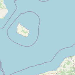
Map view of Ostoja na Zatoce Pomorskiej

Use this park location map to pinpoint Ostoja na Zatoce Pomorskiej in Poland, understand its exact geographic position, and read its mapped placement within the surrounding landscape more clearly.

Pigeon | © OpenStreetMap contributors

Visual reference guide to protected underwater habitats and coastal waters

Ostoja na Zatoce Pomorskiej Photos and Marine Landscape Scenery

Visual documentation reveals the distinct marine environment and submerged sandy shoals defining Ostoja na Zatoce Pomorskiej across the southern Baltic Sea. Examining these protected habitats helps observers understand the ecological character and open waters of the Pomeranian Bay.

A wide angle view of a sandy beach meeting the Baltic Sea at sunset, with waves washing over stones in the foreground.

Park atlas

Compare surrounding marine sanctuaries and coastal habitats across the Baltic region

Other Parks and Protected Areas Near Ostoja na Zatoce Pomorskiej

Continue geographic discovery by browsing other protected areas and marine reserves situated near Ostoja na Zatoce Pomorskiej. Comparing adjacent coastal sanctuaries helps contextualize regional biodiversity patterns and broader habitat networks.
Nature reserveZachodniopomorskie
Park boundaries overlap#1 closest

Southeast

Trzebiatowsko-Kołobrzeski Pas Nadmorski: Protected Coastal Habitat and Regional Geography

Nature reserve covering Baltic dunes, wetlands, and estuaries.

Spanning across the Szczecin Coastal Plain, this extensive nature reserve protects vital coastal habitats, including rare dune sequences, brackish lagoons, and bog forests. The area serves as a critical geographic corridor for migratory bird species and diverse sand-loving plant communities in the Zachodniopomorskie region of Poland.

Area
174.69 km²
Established
2008
Relief
Lowland
Climate
Temperate
Protected areaZachodniopomorskie
Park boundaries overlap#2 closest

South

Ujście Odry i Zalew Szczeciński: Protected Area Geography and Estuarine Landscape Mapping

Coastal lagoons, riverine deltas, and island habitats in Zachodniopomorskie.

This extensive protected area offers a comprehensive view of the Oder estuary as it meets the Baltic Sea. The landscape comprises broad lagoons, branching river channels, and coastal islands that provide crucial habitat for migratory waterbirds and sustain a rare brackish water ecosystem. Use this geographic entry to analyze the boundaries, terrain, and interconnected waterways of this major Polish nature site.

Area
526.12 km²
Established
2008
Relief
Lowland
Scope
Mixed
Watercolor painting depicting mountains, rivers, and green terrain
National parkWest Pomeranian Voivodeship
Park boundaries overlap#3 closest

Southwest

Wolin National Park: Coastal Protected Landscape and Glacial Terrain in West Pomeranian Voivodeship

Explore Poland's first marine national park and its dynamic geography.

Wolin National Park offers a profound look into Poland's protected coastal geography. This national park in the West Pomeranian Voivodeship is distinguished by its high sea cliffs, inclusion of Baltic Sea and Szczecin Lagoon waters as Poland's first marine protected area, and a landscape sculpted by glacial moraines. Discover the park's complex delta systems, ancient forests, and the mapped terrain that supports significant bird migration, providing a rich focus for atlas exploration.

Area
109.37 km²
Established
1960
IUCN
II
Visitors
1.5M annual
National parkZachodniopomorskie Voivodeship
Park boundaries overlap#4 closest

Southwest

Woliński Park Narodowy: Atlas Overview of Protected Coastal and Marine Environments

Examining moraine landscapes and marine park boundaries.

Woliński Park Narodowy stands as a critical protected area in the Zachodniopomorskie Voivodeship, blending terrestrial moraine ridges with marine ecosystems. This atlas entry provides geographic context for its coastal cliffs, inland lake district, and the expansive river delta that supports rare avian species.

Area
109.37 km²
Established
1960
Visitors
1.5M annual
Relief
Upland
Protected areaWest Pomeranian Voivodeship
Park boundaries overlap#5 closest

Southeast

Wybrzeże Trzebiatowskie Protected Area: Coastal Wetlands and Baltic Shoreline Map

A diverse wetland corridor in the West Pomeranian Voivodeship.

Wybrzeże Trzebiatowskie represents a significant stretch of the Baltic coastline, characterized by a narrow and elongated geographic profile. The protected landscape highlights a complex interplay of lagoon lakes, river floodplains, and classic dune systems, providing critical habitat within the broader West Pomeranian regional geography.

Area
317.576 km²
Established
2007
Relief
Lowland
Scope
Mixed
Nature reserveWest Pomeranian Voivodeship
About 14 km away#6 closest

Southeast

Mszar koło Siemidarżna Nature Reserve: Geography and Protected Wetland Landscapes

Mapping the peatland ecosystems of West Pomeranian Voivodeship

Examine the ecological and geographical profile of Mszar koło Siemidarżna. This nature reserve provides essential insight into the preservation of raised bogs and transitional mires in the lowlands of northwestern Poland. The site highlights the importance of buffer zones in maintaining hydrological integrity for protected pine woodland and rare bog plant species.

Area
0.209 km²
Established
2011
Relief
Lowland
Climate
Temperate
Watercolor painting of a coastal landscape with green grass in the foreground, a line of trees in the midground, and a soft pink horizon in the distance.
Protected landscapeMecklenburg-Vorpommern
About 16 km away#7 closest

Southwest

Naturpark Insel Usedom: Geography and Protected Landscape Atlas

Coastal cliffs, lagoon systems, and diverse forest terrain in Mecklenburg-Vorpommern

Naturpark Insel Usedom encompasses the German side of Usedom Island, offering a condensed landscape that bridges the Baltic Sea with inland brackish lagoons. This protected area integrates sandy shorelines, steep moraine cliffs, and varied wetland habitats, making it an essential subject for understanding the ecological and geographic character of northeastern Germany.

Area
632 km²
Established
1999
Relief
Lowland
Climate
Temperate
A horizontal watercolor painting showing rolling green hills and a dense forest line against a pale, light-colored sky background.
Protected landscapeWest Pomeranian Voivodeship
17 km away#8 closest

South

Puszcza Goleniowska Protected Landscape: Geographic Profile and Mapped Boundaries

A large-scale lowland forest complex in West Pomeranian Voivodeship.

Puszcza Goleniowska represents a critical protected woodland in Poland, spanning 630 square kilometers of post-glacial plains. This forest complex is characterized by its pine-dominated canopy, widespread bog and marshland habitats, and a series of rivers and lakes that form the backbone of its regional drainage. The area encompasses numerous nature reserves and Natura 2000 sites, offering a comprehensive look at the lowland ecological structure of the West Pomeranian Voivodeship.

Area
630 km²
Established
1349
Relief
Lowland
Climate
Temperate

Common questions about visiting, size, designation, and location context for Ostoja na Zatoce Pomorskiej

Ostoja na Zatoce Pomorskiej FAQs for park facts, access, geography, and protected area context

Find quick answers about Ostoja na Zatoce Pomorskiej, including protected-area facts, park geography, trail and visitor context, and how the park fits into its surrounding country and regional landscape.
MoriAtlas Explorer

Continue Your Protected Areas Search Across the Global Atlas

Deepen your exploration by continuing the structured search for national parks and protected areas worldwide. Utilize the comprehensive filtering capabilities to compare different conservation landscapes and refine your understanding of global park geography. Discover more about the distribution and characteristics of protected natural areas.

Global natural geography