

Mori Atlas logo
Protected areaPagaibamba Protection Forest

Discover the watershed protection and highland ecosystem characteristics of this northern Peruvian reserve

Pagaibamba Protection Forest: Mapped Boundaries and Andean Mountain Landscape Geography

(Bosque de Protección Pagaibamba)

Pagaibamba Protection Forest occupies a critical stretch of the northern Peruvian Andes, spanning elevations from 2,300 to 2,800 meters within the Cajamarca region. This protected area functions as a vital watershed for surrounding communities, combining rugged cloud forest terrain with steep ridges and small creeks. The landscape features a distinct mosaic of native tree cover, bamboo grasses, and high-altitude vegetation, playing a functional role in preventing soil erosion and maintaining infrastructure stability in the mountain environment.

cloud forestAndesCajamarcamountain forestwatershed protectionprotected forest

Pagaibamba Protection Forest

Protected area

Park overview

Structured park overview, official facts, and landscape profile for Pagaibamba Protection Forest

Pagaibamba Protection Forest park facts, protected area profile, and essential visitor context

Review the core facts for Pagaibamba Protection Forest, including designation, size, terrain, visitor scale, habitats, and operating context in one park-focused overview.

About Pagaibamba Protection Forest

Pagaibamba Protection Forest is a relatively compact but ecologically important protected area in the Cajamarca department of northern Peru. Tucked into the highlands of Querocoto District in Chota Province, the reserve sits at elevations between roughly 2,300 and 2,800 meters, occupying mountain terrain that has been shaped by steep slopes, narrow valleys, and a network of small creeks. Water is a defining feature of the landscape both ecologically and culturally; the forest was created in 1987 specifically to safeguard the water supply of surrounding communities and to stabilize the hydrological cycle that supports them.

The vegetation of Pagaibamba belongs to the wet tropical mountain forest category of the Holdridge system, a classification that reflects the combination of high elevation and considerable rainfall characteristic of many Andean cloud forests. The forest supports a mix of native tree species along with palm trees, tree ferns, and the bamboo-like Chusquea, interspersed with open patches of tall grasses. This vegetation pattern creates a mosaic of habitats across the reserve, ranging from denser forested slopes to more open highland cover.

Wildlife in the reserve reflects the broader biodiversity of the northern Peruvian Andes. The forest provides habitat for mammals such as the spectacled bear, the puma, the white-tailed deer, the Andean fox, and smaller species including the montane guinea pig and the mountain tapir. Birdlife includes striking highland species such as the Andean condor, the razor-billed curassow, and the Andean guan. The reserve is also of scientific interest because of the presence of Thomasomys pagaibambensis, a rodent known exclusively from this forest, and Pristimantis chimu, a frog reported in the area.

Unlike a strictly preserved wilderness area, Pagaibamba is classified as an IUCN Category VI protected landscape, a designation that allows for sustainable use of natural resources alongside conservation. Management responsibility lies with SERNANP, Peru's national service for protected natural areas. Activities in and around the forest are generally limited to nature watching, trekking, and scientific research, keeping the focus on quiet enjoyment and study rather than mass tourism.

Quick facts and research context for Pagaibamba Protection Forest

Pagaibamba Protection Forest covers approximately 2,078 hectares of mountainous terrain in Querocoto District, Chota Province, northern Peru. It was formally established on June 19, 1987, and is governed by Peru's national protected areas service, SERNANP, with an IUCN protected-area category of VI, indicating a sustainable-use designation.

The reserve lies in the Cajamarca region and spans elevations between roughly 2,300 and 2,800 meters above sea level. Its climate is cool and moist, with mean annual temperatures usually between about 7 and 11 degrees Celsius and precipitation ranging from around 830 to 1,720 millimeters per year, depending on local conditions.

Protection and recognition

Explore documented conservation scope and formal recognition metrics for Pagaibamba Protection Forest

Pagaibamba Protection Forest Protection Status and Terrestrial Designation Facts

Terrestrial protection status and administrative parameters define the conservation scope of Pagaibamba Protection Forest within the global park registry. Detailed designation records outline international recognition data and official management parameters for conservation analysis.

Protection details

Protection scope
Terrestrial
Transboundary protection
No
Park context

Deeper park guide and search-rich context for Pagaibamba Protection Forest

Pagaibamba Protection Forest history, landscape, wildlife, and travel context

Explore Pagaibamba Protection Forest through its history, landscape character, ecosystems, wildlife, conservation priorities, cultural context, and seasonal travel timing in a structured park guide built for atlas discovery and search intent.

Why Pagaibamba Protection Forest stands out

Pagaibamba is best known for the way it blends watershed protection with cloud forest conservation. Its declaration as a protection forest was specifically tied to securing water resources for nearby towns, regulating the local water cycle, and reducing soil erosion on steep Andean slopes. The forest is also recognized for its humid mountain vegetation, which includes native conifers such as Podocarpus, highland trees like Polylepis (queñual) and Alnus acuminata (aliso), palm trees, tree ferns, and dense stands of Chusquea bamboo and tall grasses. Among its wildlife, the reserve is notable for hosting a rodent species, Thomasomys pagaibambensis, which is known only from this area.
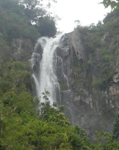
A tall waterfall cascades over a steep, dark, rocky cliff surrounded by dense green forest foliage.
The El Chorro Blanco waterfall flows down a rocky cliff within the Pagaibamba Protection Forest.

Pagaibamba Protection Forest history and protected-area timeline

Pagaibamba Protection Forest was formally established on June 19, 1987, under Peru's national protected areas framework. Its creation was not oriented primarily around scenic preservation but around the practical protection of water and soil resources in a heavily used agricultural region of northern Peru.

By designating the area as a protection forest, authorities sought to ensure a stable water supply for nearby communities, regulate the local water cycle, protect road infrastructure that crosses the steep Andean terrain, and reduce erosion on vulnerable mountain slopes. This watershed-protection rationale has continued to shape the management of the reserve and set it apart from many other Peruvian protected areas whose founding stories emphasize wilderness or scenic values.

Since its establishment, the forest has also faced ongoing environmental challenges. In late 2016, Pagaibamba was affected along with other protected areas in northern Peru by human-caused forest fires linked to slash-and-burn agriculture escaping control during drought conditions. These events highlighted the continuing tension between agricultural land use and forest conservation that has shaped the reserve's modern history.

Pagaibamba Protection Forest landscape and geographic character

The physical setting of Pagaibamba Protection Forest is defined by the rugged character of the northern Peruvian Andes. The reserve sits at elevations between roughly 2,300 and 2,800 meters, occupying mountainous terrain that has been carved over time by water and gravity into steep slopes, narrow valleys, and dissected ridges.

Small creeks weave through the landscape, draining the forested slopes and feeding into larger watersheds that supply surrounding communities. Waterfalls are a notable scenic feature within the reserve, and the combination of moisture, elevation, and forest cover creates the cool, humid conditions typical of Andean cloud forest environments. Roads running through or near the area make the protected forest's role in protecting infrastructure especially important, since hillside erosion and landslides pose risks to these routes.

The terrain alternates between densely forested areas and more open stretches covered in tall grasses, with the underlying topography remaining steep and uneven throughout. This mosaic of closed forest and open highland ground shapes both how water moves through the landscape and how visitors experience the reserve.

Pagaibamba Protection Forest ecosystems, habitats, and plant life

Ecologically, Pagaibamba falls within the wet tropical mountain forest zone of the Holdridge life zones system, a category that captures the cool temperatures and substantial moisture typical of middle-elevation Andes habitats. This places the reserve firmly within the broader Andean cloud forest biome, where persistent humidity supports dense vegetation and high biodiversity.

The vegetation reflects this ecological setting. Native conifers in the genus Podocarpus grow alongside highland broadleaf trees such as species of Ocotea and Myrcianthes, the characteristic Polylepis trees known locally as queñual, and Alnus acuminata, known as aliso. Palm trees and tree ferns add a distinctive Andean cloud-forest character, while extensive stands of Chusquea, a bamboo-like genus, and tall grasses fill more open spaces and forest edges.

This mix of forest types creates habitat heterogeneity across the reserve. Steeper, more sheltered slopes tend to support denser tree cover, while ridges and disturbed areas carry more grass and shrub cover. The resulting mosaic supports a wide range of wildlife niches and contributes to the resilience of the watershed functions that the forest was established to protect.

Pagaibamba Protection Forest wildlife and species highlights

The fauna of Pagaibamba is characteristic of northern Andean cloud forests and includes several mammals of regional conservation importance. Larger mammals such as the spectacled bear, the puma, and the white-tailed deer inhabit or move through the reserve, while smaller mammals include the Andean fox, the montane guinea pig, the mountain tapir, the tapeti (a forest-dwelling rabbit), and the pacarana, a large South American rodent.

Birds are similarly diverse and include some of the most striking species of the northern Andes. The Andean condor, an emblem of mountain landscapes across South America, has been recorded in the area, alongside cracid species such as the razor-billed curassow and the Andean guan, both of which are large forest birds sensitive to habitat disturbance.

Pagaibamba also holds particular scientific value because of endemic and restricted-range species. The rodent Thomasomys pagaibambensis is known only from this forest, making the reserve critical for the survival of that species, and the frog Pristimantis chimu has been reported in the area as well. These narrow-range species underscore the importance of Pagaibamba for Andean biodiversity beyond its role as a watershed protector.

Pagaibamba Protection Forest conservation status and protection priorities

The fundamental conservation purpose of Pagaibamba Protection Forest is watershed and soil protection. By maintaining continuous forest cover at middle elevations, the reserve helps regulate the flow of water from the surrounding mountains into the streams that supply local communities, while also reducing erosion on steep slopes that would otherwise degrade water quality and threaten road infrastructure.

Beyond these hydrological functions, the reserve contributes to broader biodiversity conservation in the Cajamarca region. The presence of endemic species such as Thomasomys pagaibambensis and the range of mammals and birds recorded here give the forest genuine biological significance within Peru's network of protected areas, even at a relatively modest size.

The IUCN Category VI designation reflects the idea that conservation and sustainable human use can coexist at Pagaibamba. Management, led by SERNANP, is oriented toward maintaining forest cover and ecosystem function rather than excluding all human activity, although the reserve has nonetheless faced serious external pressures. Deforestation remains a concern in and around the area, and the forest fires that affected Pagaibamba and other northern Peruvian protected areas in late 2016, driven by slash-and-burn agriculture and drought, illustrate the ongoing conservation challenges facing middle-elevation Andean forests.

Pagaibamba Protection Forest cultural meaning and human context

Pagaibamba lies in a part of Cajamarca where rural agriculture and highland landscape are deeply intertwined, and the reserve's existence reflects local recognition of forests as essential water and soil infrastructure. The protection forest was established not in a distant wilderness but immediately adjacent to populated valleys and agricultural land, making the cultural relationship with the landscape unusually direct.

Slash-and-burn agriculture has historically shaped land use in parts of the surrounding region, and the conflicts that have produced fires in protected forests such as Pagaibamba in 2016 highlight the cultural and economic weight of traditional farming practices even as they create conservation risks. Local naming and use of plant species in Spanish, including saucecillo for Podocarpus, roble amarillo for Ocotea, lanche for Myrcianthes, suro for Chusquea, queñual for Polylepis, and aliso for Alnus acuminata, point to a long-standing tradition of intimate knowledge of the highland forest.

Top sights and standout views in Pagaibamba Protection Forest

Pagaibamba Protection Forest stands out as a rare case where a small Andean reserve is formally recognized for protecting water, soil, and infrastructure rather than for scenery alone. Its location in the Cajamarca highlands, its designation as an IUCN Category VI protection forest, and its direct link to the water supply of surrounding communities give it a distinctive practical identity.

At the same time, the reserve is genuinely wild in character, with cloud-forest vegetation, waterfalls, steep mountain creeks, and wildlife including spectacled bears, mountain tapirs, and Andean condors. The presence of Thomasomys pagaibambensis, a rodent known only from Pagaibamba, and the frog Pristimantis chimu further underscores the scientific importance of this compact but ecologically significant reserve.

Best time to visit Pagaibamba Protection Forest

Because Pagaibamba sits between roughly 2,300 and 2,800 meters in the Cajamarca highlands, the climate is cool throughout the year, with annual mean temperatures typically in the range of about 7 to 11 degrees Celsius and substantial rainfall, particularly during wetter months, that can affect trail conditions.

Visitors interested in trekking and nature watching will generally find more stable conditions during drier phases of the year, when the forest trails, creeks, and waterfalls are easier to access. The wetter season brings heavier precipitation and the higher risk of weather-related disruptions, but it is also when cloud forest conditions are most pronounced and when water-dependent features of the landscape, including waterfalls and streams, are at their most dramatic.

Monthly climate preview

Long-term temperature and precipitation records measured across representative coordinates

Pagaibamba Protection Forest Climate Normals and Annual Weather Rhythm

Pagaibamba Protection Forest maintains a consistent baseline of monthly temperature measurements alongside distinct seasonal precipitation shifts recorded at a representative coordinate. Examining the complete twelve-month climatology profile reveals comprehensive variations in average maximums and daily minimums across the protected terrain.
Annual mean21 °C
20 °C22 °C
Jan21°
Feb22°
Mar22°
Apr22°
May22°
Jun21°
Jul21°
Aug21°
Sep21°
Oct21°
Nov20°
Dec21°
Warmest month
March

22 °C

Coolest month
November

20.2 °C

Wettest month
February

1.4 mm/day

Driest month
August

0.1 mm/day

Park location guide

Geography guide, regional context, and park location map for Pagaibamba Protection Forest

Pagaibamba Protection Forest park geography, regions, and map view in Peru

Understand where Pagaibamba Protection Forest sits in Peru through a broader geographic reading of the surrounding landscape, nearby location context, and its mapped position within the national park landscape.

How Pagaibamba Protection Forest fits into Peru

Peru is a megadiverse country in western South America with a population of over 34 million. It spans three distinct geographic regions: the Pacific coastal desert in the west, the Andes mountains running north to south, and the Amazon rainforest in the east. The country has one of the longest histories of civilization in the world, tracing back to the Caral-Supe civilization of the 10th millennium BCE, and was home to the Inca Empire before Spanish colonization in the 16th century.

Wider geography shaping Pagaibamba Protection Forest in Peru

Peru is located in western South America along the Pacific coast. The country encompasses three major geographic regions: the coastal desert plains along the Pacific, the Andes mountain range extending from north to southeast, and the Amazon basin rainforest in the eastern interior. It shares borders with Ecuador and Colombia to the north, Brazil to the east, Bolivia to the southeast, and Chile to the south.

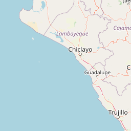
Map view of Pagaibamba Protection Forest

Use this park location map to pinpoint Pagaibamba Protection Forest in Peru, understand its exact geographic position, and read its mapped placement within the surrounding landscape more clearly.

Pigeon | © OpenStreetMap contributors

Location context for Pagaibamba Protection Forest

Cajamarca Region
Recorded earthquake history

Review the Historical Earthquake Catalogue for Pagaibamba Protection Forest

Explore a structured record of historical earthquakes associated with the mountainous terrain of Pagaibamba Protection Forest. MoriAtlas provides this archived data to assist with geographic study and spatial analysis of seismic patterns in the Cajamarca region.

Pagaibamba Protection Forest Earthquake History

Catalogued events

5 events

Strongest magnitude

Magnitude 4.9

Most recent event

Jun 22, 2023

This history includes earthquakes recorded inside the park or within 50 km of its borders

Visualizing Andean cloud forest terrain, steep river valleys, and protected watershed habitats in northern Peru

Pagaibamba Protection Forest Photos and Mountain Landscape Scenery

Examine high-resolution imagery showcasing the rugged topography, humid cloud forest vegetation, and steep Andean terrain of Pagaibamba Protection Forest. Visual documentation reveals the distinct ecological character of these protected mountain habitats, offering clear insight into regional watershed geography.

A tall waterfall cascades over a steep, dark, rocky cliff surrounded by dense green forest foliage.

Park atlas

Compare adjacent protected areas, regional geography, and connected mountain terrain.

Explore Other Parks Near Pagaibamba Protection Forest and Surrounding Andean Landscapes

Browse other parks and protected areas located near Pagaibamba Protection Forest across the northern Peruvian Andes. Comparing these regional reserves provides deeper geographic context into highland cloud forests, watershed ecosystems, and rugged mountain terrain.
Wildlife reserveCajamarca
23 km away#1 closest

South

Bosques Nublados de Udima Wildlife Refuge: Protected Andean Cloud Forest and River Basin

A critical mountain reserve in the Cajamarca region of northern Peru.

Situated on the dramatic western slopes of the Andes, Bosques Nublados de Udima Wildlife Refuge protects 12,183 hectares of cloud forest ecosystem. The reserve is characterized by a sharp vertical gradient dropping over 1,000 metres toward the Zaña River basin, preserving both rare Amazonian-linked plant species and significant pre-Columbian archaeological irrigation structures.

Area
121.83 km²
Established
2011
IUCN
IV
Relief
Mountain
National parkCajamarca Region
27 km away#2 closest

Northeast

Cutervo National Park: Peru's Oldest National Park Atlas and Protected Landscape

Andean Montane Forests and Mapped Geography of a Pioneering Protected Area

As Peru's oldest national park, established in 1961, Cutervo National Park offers a unique glimpse into the protected geography of the northern Peruvian Andes. Located in the Cajamarca Region, it preserves diverse Andean montane forests and páramo grasslands across a significant elevation gradient from 1,550 to 3,500 meters. This page details the park's landscape, including its role as a headwater conservation area and its position within a critical South American ecoregion, providing rich context for geographic and protected-area exploration.

Area
82.14 km²
Established
1961
IUCN
II
Relief
Mountain
Wildlife reserveLambayeque Region
39 km away#3 closest

West

Laquipampa Wildlife Refuge: Geography and Protected Area Map of Northern Peru

Tracing the tropical dry forest boundaries of the Lambayeque Region

Laquipampa Wildlife Refuge stands as a critical protected landscape within the Lambayeque Region, preserving rare tropical dry forest ecosystems along the western Andean foothills. The refuge features a unique vertical gradient, ranging from exposed dry-forest slopes to moist highland ravines. Use this atlas resource to understand the park's mapped boundaries, diverse terrain, and central role in regional conservation.

Area
113.47 km²
Established
2006
IUCN
IV
Visitors
2K annual
Wildlife reserveCajamarca Region
112 km away#4 closest

Southeast

Sunchubamba Game Reserve: Geographic Overview of Protected Andean Landscapes in Northern Peru

Examining dry forest ecosystems and managed habitat in the Cajamarca Region

Explore the unique environmental footprint of Sunchubamba Game Reserve, a protected area in northern Peru characterized by its blend of native dry forests and non-native tree plantations. This record details the reserve as a historical hacienda site that now serves as an important study in land-use, wildlife management, and the evolution of Andean highland conservation practices.

Area
597.35 km²
Established
1977
IUCN
VI
Relief
Mountain
Wildlife reserveAmazonas Region
125 km away#5 closest

Northeast

Chayu Nain Communal Reserve: Mapped Protected Landscapes and Regional Geography in Peru

Andes to Amazon ecological transition zone in the Amazonas region

Chayu Nain Communal Reserve functions as a critical stronghold for endemic wildlife and represents a major achievement in communal conservation. Its sandstone geology and elevational gradients create a distinct terrain that sustains rare primate populations, lowland tapirs, and complex forest mosaic habitats in northern Peru.

Area
235.98 km²
Established
2009
IUCN
VI
Relief
Upland
A watercolor illustration of layered green hills and distant mountain ridgelines, depicted in soft pastel tones against a white background.
Nature reserveSan Martin
155 km away#6 closest

Northeast

Alto Mayo Protection Forest: Geographic Boundaries and Andean Slope Landscape Mapping

Protected watershed and cloud forest in San Martin, Peru

Spanning the eastern Andes, Alto Mayo Protection Forest functions as a foundational watershed for the Mayo River basin. This reserve preserves significant cloud forest habitats and high-gradient terrain, serving as an important link between Andean highlands and the Amazonian lowlands. Study the topographic features, hydrological network, and protected boundaries that define this crucial Peruvian wilderness.

Area
1,820 km²
Established
1987
IUCN
VI
Relief
Mountain
National parkZamora Chinchipe
174 km away#7 closest

North

Yacurí National Park: Protected Andean Lakes and Volcanic Landscape in Zamora Chinchipe

Discover highland geography and the ancient Inca Trail.

Yacurí National Park is a key protected landscape in Ecuador's southern Andes, celebrated for its remarkable collection of over 46 high-altitude lakes set within dramatic volcanic terrain. Situated in Zamora Chinchipe province, the park preserves a vital stretch of the Inca Trail, complete with archaeological sites. This national park offers a rich exploration of Andean geography, páramo ecosystems, and significant cultural heritage, making it a cornerstone of the region's protected areas.

Area
431 km²
Established
2009
IUCN
II
Relief
Mountain
Nature reserveZamora Chinchipe
187 km away#8 closest

North

Reserva Biológica Cerro Plateado: Andean and Amazonian Landscape and Protected Area Context

Vertical gradient and mountain forest geography in Zamora Chinchipe

Spanning elevations from 840 to 3,120 meters, Reserva Biológica Cerro Plateado represents a significant conservation effort within the Zamora Chinchipe province. The reserve preserves intact montane cloud forests and paramo, serving as a vital link between the eastern Andean slopes and the Nangaritza watershed in southeastern Ecuador.

Area
307.607 km²
Established
2010
IUCN
Ia
Relief
Mountain

Common questions about visiting, size, designation, and location context for Pagaibamba Protection Forest

Pagaibamba Protection Forest FAQs for park facts, access, geography, and protected area context

Find quick answers about Pagaibamba Protection Forest, including protected-area facts, park geography, trail and visitor context, and how the park fits into its surrounding country and regional landscape.
MoriAtlas Explorer

Continue Your Protected Areas Search Across the Global Atlas

Deepen your exploration by continuing the structured search for national parks and protected areas worldwide. Utilize the comprehensive filtering capabilities to compare different conservation landscapes and refine your understanding of global park geography. Discover more about the distribution and characteristics of protected natural areas.

Global natural geography
