
Mori Atlas logo
Marine protected areaParc maritime départemental Estérel-Théoule

Tracing the coastal corridor from the Estérel massif into the diverse Mediterranean seafloor

Parc maritime départemental Estérel-Théoule: A Mediterranean Marine Protected Area Map and Geography

Parc maritime départemental Estérel-Théoule represents a vital marine conservation link along the French Riviera, extending the protection of the Estérel coastline into the Mediterranean Sea. Spanning the waters off Théoule-sur-Mer, this protected area features a complex mosaic of Posidonia seagrass meadows, coralligenous algae formations, and varied rocky substrates. It functions as a critical natural transition between the rugged red porphyry ridges of the inland landscape and the coastal environments of Provence-Alpes-Côte d'Azur.

marine parkcoastal protected areaMediterraneanunderwater trailseagrass meadowscoralligenous algae
A graphic illustration of a mountainous valley scene, featuring jagged cliffs, a tiered waterfall, a winding stream, and coniferous trees in a flat, pastel-colored art style.

Parc maritime départemental Estérel-Théoule

Marine protected area

Park overview

Structured park overview, official facts, and landscape profile for Parc maritime départemental Estérel-Théoule

Parc maritime départemental Estérel-Théoule park facts, protected area profile, and essential visitor context

Review the core facts for Parc maritime départemental Estérel-Théoule, including designation, size, terrain, visitor scale, habitats, and operating context in one park-focused overview.

About Parc maritime départemental Estérel-Théoule

The Parc maritime départemental Estérel-Théoule is a comparatively small but ecologically important marine protected area on the Côte d'Azur. It lies offshore from Théoule-sur-Mer, the easternmost commune of the Alpes-Maritimes along the Cannes bay coastline, and sits at the foot of the Estérel massif, whose red porphyry ridges are among the most distinctive geological features of the French Mediterranean coast.

Although the park itself covers only around 3.5 square kilometres, its significance comes from its position within a wider network of natural spaces. To the east it borders the Pointe de l'Aiguille departmental park, while the much larger Estérel departmental natural park extends inland across roughly 959 hectares shared with Mandelieu-La Napoule. Together, these protected areas create a continuous natural corridor from the red-rock hills of the Estérel down into the Mediterranean Sea.

The marine park is managed by the Conservatoire du littoral, the French coastal protection agency, and is treated as a protected natural area (parc naturel). Its core value lies in the diversity of shallow-water habitats concentrated along a short stretch of coast. Within a relatively limited area, visitors and researchers can find rocky bottoms, pebble fields, sandy banks, Posidonia meadows, and coralligenous algae communities, each of which supports a different assemblage of Mediterranean marine life.

These habitats also make the park one of the most accessible underwater discovery sites on this part of the coast. The underwater trail at Pointe de l'Aiguille, operational since 2006 and open from mid-June to mid-September, lets visitors explore the marine life of the shallow zones near the surface, supported by educational interpretation materials available at the local tourist office.

Quick facts and research context for Parc maritime départemental Estérel-Théoule

The Parc maritime départemental Estérel-Théoule is a departmental marine protected area in the Alpes-Maritimes, on the Mediterranean coast of southeastern France. It covers approximately 3.5 square kilometres of coastal waters just east of the Estérel massif, off the commune of Théoule-sur-Mer, and is managed by the Conservatoire du littoral.

The park functions as the maritime extension of two nearby departmental protected areas: the Parc départemental de la Pointe de l'Aiguille to the west and the larger Estérel departmental natural park, which extends across Mandelieu-La Napoule and Théoule-sur-Mer. It protects a mosaic of Mediterranean shallow-water habitats and includes an underwater interpretation trail created in 2006.

Park context

Deeper park guide and search-rich context for Parc maritime départemental Estérel-Théoule

Parc maritime départemental Estérel-Théoule history, landscape, wildlife, and travel context

Explore Parc maritime départemental Estérel-Théoule through its history, landscape character, ecosystems, wildlife, conservation priorities, cultural context, and seasonal travel timing in a structured park guide built for atlas discovery and search intent.

Why Parc maritime départemental Estérel-Théoule stands out

The park is best known for its mosaic of Mediterranean shallow-water habitats. Along its shoreline, rocky and pebble bottoms alternate with sandy patches, meadows of Neptune grass (Posidonia oceanica), and coralligenous algae formations that together shelter unusually varied marine biodiversity for a coastal site of its size. It is also recognized for the underwater discovery trail at Pointe de l'Aiguille, opened in 2006, which allows visitors to observe the underwater life of these shallow habitats using educational plaques. The park is equally defined by its role in connecting coastal and inland protected spaces along the Estérel coast.
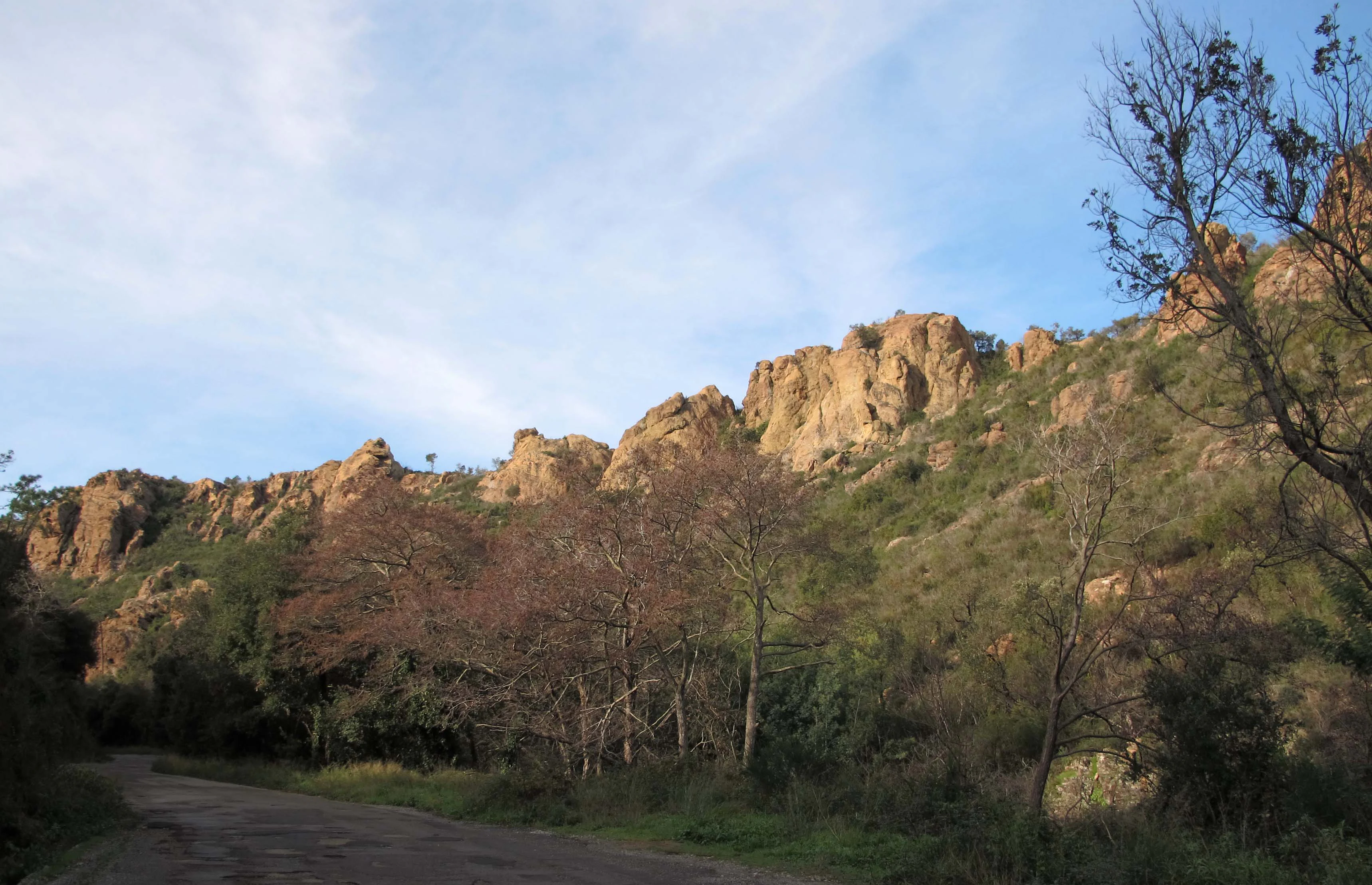
A wide angle view of reddish rocky ridgelines rising above a treed valley with a dirt path in the foreground.
The craggy rock formations of the Vallon de la Rague bordering the park area.

Parc maritime départemental Estérel-Théoule history and protected-area timeline

The Parc maritime départemental Estérel-Théoule was established as part of the Alpes-Maritimes department's effort to extend its network of departmental natural areas seaward. It was placed under the management of the Conservatoire du littoral, the national agency responsible for protecting fragile stretches of the French coast, integrating it into a broader system of protected coastlines along the Mediterranean.

A key milestone in the park's development was the creation of the underwater discovery trail (sentier sous-marin) at Pointe de l'Aiguille in 2006. This trail opened the marine area's habitats to public interpretation during the summer months, marking a turning point in making the park not only a conservation site but also an educational destination.

More recently, the Alpes-Maritimes department has reinforced the park's role within its sports and leisure framework. Through the Plan Départemental des Espaces, Sites et Itinéraires (PDESI), the department has installed two ecological mooring areas specifically reserved for diving clubs, designed to limit damage caused by repeated anchoring on the sensitive seafloor habitats.

Parc maritime départemental Estérel-Théoule landscape and geographic character

The park's setting is defined by the dramatic transition from the Estérel massif to the Mediterranean Sea. The red porphyry ridges of the Estérel, a defining landmark of the Côte d'Azur, fall steeply toward the coast around Théoule-sur-Mer, where the rocky mainland shoreline meets the sea.

Beneath the surface, the underwater landscape is unusually varied for a coastal site. The shoreline gives way to a patchwork of shallow rocky bottoms, pebble beds, and sandy patches within a short distance of the coast. Among the most distinctive features are the meadows of Posidonia oceanica, a protected Mediterranean seagrass that forms dense underwater prairies, and the coralligenous algae formations that colonize the rocky substrates at greater depths.

This compact concentration of contrasting substrates, from hard rock to soft sand and living seagrass, creates a richly textured Mediterranean seafloor in which small-scale changes in depth and bottom type lead to clearly different underwater environments.

Parc maritime départemental Estérel-Théoule ecosystems, habitats, and plant life

Ecologically, the park spans the interface between the terrestrial Estérel massif and the marine environment of the Gulf of Napoule. Its protected status focuses specifically on the shallow-water marine habitats, which together form one of the Mediterranean's classic habitat mosaics: rocky and pebble substrates colonized by algae and encrusting organisms, sandy patches used by burrowing species, Posidonia seagrass meadows that act as nurseries for many species, and coralligenous formations that support some of the richest biodiversity per square metre in the Mediterranean.

Posidonia meadows in particular play a central ecological role, stabilizing the seafloor, oxygenating the water, and providing shelter and food for a wide range of fish and invertebrates. The coralligenous algae communities add a second layer of structural complexity on harder substrates. Together, these habitats give the park an ecological density that is not obvious from its modest surface area alone.

The park's ecological value is further reinforced by its function as the submerged continuation of the protected Estérel coast, linking the inland red-rock hills and coastal cliffs to offshore shallow-water communities.

Parc maritime départemental Estérel-Théoule wildlife and species highlights

The mosaic of habitats found in the park supports a wide variety of Mediterranean marine life. Posidonia meadows, in particular, function as nursery areas for many fish species, while the coralligenous algae provide shelter for slow-growing invertebrates, including sponges, gorgonians, and other filter-feeding organisms typical of the Mediterranean.

The rocky and pebble bottoms attract species adapted to hard substrates, and the sandy patches add yet another faunal layer, with burrowing invertebrates and flatter fish communities. The combination of so many habitats within a limited coastal sector is what gives the park its particular interest for underwater wildlife observation, especially along the underwater trail at Pointe de l'Aiguille, where visitors can see this biological diversity up close.

Parc maritime départemental Estérel-Théoule conservation status and protection priorities

As a departmental marine protected area managed by the Conservatoire du littoral, the park is explicitly designed to protect a stretch of Mediterranean coastline facing pressure from coastal development, boating, and recreational anchoring. Its conservation value lies less in its size than in the diversity of sensitive habitats it concentrates within a small area, including Posidonia meadows and coralligenous formations, both of which are considered priorities for Mediterranean marine conservation.

The park is also integrated into a wider conservation network. It continues the protection of the Pointe de l'Aiguille departmental coastal park to the east and links with the larger Estérel departmental natural park inland, helping to maintain ecological continuity from the mountains to the sea.

In practical terms, protection is reinforced by management measures aimed at the main threats to the seafloor. The installation of two ecological mooring areas for diving clubs, implemented through the Plan Départemental des Espaces, Sites et Itinéraires, is specifically intended to reduce anchor damage on the sensitive shallow habitats and so preserve the integrity of the underwater environments that justify the park's protected status.

Parc maritime départemental Estérel-Théoule cultural meaning and human context

The park is embedded in the landscape and identity of the Côte d'Azur, where the red rocks of the Estérel have long been a recognizable natural landmark separating the more urbanized Bay of Cannes from the Calanques further west. The marine park's location off Théoule-sur-Mer places it at the boundary between the developed Riviera coastline and the wilder Estérel coast, a transition that has historically shaped local perceptions of nature and tourism in the area.

The underwater discovery trail at Pointe de l'Aiguille also reflects a regional tradition of making Mediterranean marine environments accessible for education and public appreciation, fitting within a broader culture of coastal recreation along the Alpes-Maritimes coast.

Top sights and standout views in Parc maritime départemental Estérel-Théoule

The park's standout features include the exceptional habitat diversity found in a small coastal area, ranging from Posidonia seagrass meadows and coralligenous formations to rocky, sandy, and pebble substrates. Equally distinctive is the underwater discovery trail at Pointe de l'Aiguille, operational since 2006 and open from mid-June to mid-September, which offers guided interpretation of the marine life using educational plaques available from the local tourist office.

Another defining point is its role as the maritime extension of a larger departmental conservation network, linking the Pointe de l'Aiguille coastal park and the inland Estérel natural park into a single continuous natural corridor from the mountains to the sea.

Best time to visit Parc maritime départemental Estérel-Théoule

Given the park's underwater focus, the most relevant period for visiting is summer, when the underwater discovery trail at Pointe de l'Aiguille is accessible, from mid-June to mid-September. During these months, calmer Mediterranean conditions and warmer sea temperatures make shallow-water observation most pleasant.

Outside of this window, the park's interest shifts to its broader landscape setting, where the combination of the Estérel massif and Mediterranean shoreline can be appreciated from the coast, particularly in spring when coastal vegetation is most active and in early autumn when marine conditions remain generally mild.

Monthly climate preview

Long-term representative point measurements of temperature and monthly precipitation

Parc maritime départemental Estérel-Théoule Climate Normals and Annual Weather Patterns

Long-term data records trace the measured annual rhythm of average temperatures and monthly precipitation recorded at a representative coordinate within Parc maritime départemental Estérel-Théoule. Detailed month-by-month climate profiles expand this baseline overview with complete tabular datasets.
Annual mean15 °C
8 °C25 °C
Jan
Feb
Mar10°
Apr13°
May17°
Jun21°
Jul24°
Aug25°
Sep20°
Oct16°
Nov12°
Dec
Warmest month
August

24.6 °C

Coolest month
January

7.9 °C

Wettest month
November

3.8 mm/day

Driest month
July

0.5 mm/day

Park location guide

Geography guide, regional context, and park location map for Parc maritime départemental Estérel-Théoule

Parc maritime départemental Estérel-Théoule park geography, regions, and map view in France

Understand where Parc maritime départemental Estérel-Théoule sits in France through a broader geographic reading of the surrounding landscape, nearby location context, and its mapped position within the national park landscape.

How Parc maritime départemental Estérel-Théoule fits into France

France is a unitary semi-presidential republic and one of the world's largest economies. It borders Belgium, Luxembourg, Germany, Switzerland, Italy, Monaco, Andorra, and Spain, with a maritime border to the United Kingdom. The country is known for its cultural influence, art, cuisine, and political history spanning centuries.

Wider geography shaping Parc maritime départemental Estérel-Théoule in France

France is located in Western Europe. Metropolitan France extends from the Rhine to the Atlantic Ocean and from the Mediterranean Sea to the English Channel and North Sea. The country borders Belgium, Luxembourg, Germany, Switzerland, Italy, Monaco, Andorra, Spain, and has a maritime border with the United Kingdom.

Map view of Parc maritime départemental Estérel-Théoule

Use this park location map to pinpoint Parc maritime départemental Estérel-Théoule in France, understand its exact geographic position, and read its mapped placement within the surrounding landscape more clearly.

Pigeon | © OpenStreetMap contributors

Location context for Parc maritime départemental Estérel-Théoule

Provence-Alpes-Côte d'Azur

Visualizing Mediterranean marine habitats, coastal terrain, and protected waters

Parc maritime départemental Estérel-Théoule Photos and Landscapes

Visual documentation reveals the dramatic transition from the red porphyry ridges of the Estérel massif into the rich underwater habitats of the Mediterranean Sea. Detailed photography illustrates shallow rocky bottoms, seagrass meadows, and coralligenous formations that define the character of this protected coastal strip.

A wide angle view of reddish rocky ridgelines rising above a treed valley with a dirt path in the foreground.

Park atlas

Compare surrounding Mediterranean marine reserves, coastal parks, and inland conservation corridors.

Parks Near Parc maritime départemental Estérel-Théoule and Adjacent Protected Landscapes

Browsing other protected areas near Parc maritime départemental Estérel-Théoule reveals connected coastal and inland natural spaces across the French Riviera. Comparing adjacent marine reserves and mountain parks provides broader geographic context for regional conservation corridors.
Marine protected areaFrance
Mapped location lies within the park boundary#1 closest

East

Sanctuaire Pelagos Marine Protected Area: Mediterranean Geography and Seascape

A transboundary conservation zone spanning 87,500 square kilometers.

Sanctuaire Pelagos represents a unique collaborative effort in marine conservation across the Mediterranean. Spanning the waters between France, Italy, and Monaco, this protected maritime area is defined by its deep-sea canyons and nutrient-rich currents that sustain diverse cetacean populations. Its immense scale and international governance make it a focal point for understanding Mediterranean marine biodiversity and environmental policy.

Area
87,500 km²
Established
1999
IUCN
IV
Relief
Lowland
Watercolor painting of a park landscape with a foreground pond, grassy areas, and rolling hills in the background.
State or regional parkProvence-Alpes-Côte d'Azur
About 19 km away#2 closest

Northeast

Parc de Vaugrenier: Regional Protected Area and Archaeological Landscape in France

Wetland habitats and historic trails in Alpes-Maritimes

Parc de Vaugrenier protects a diverse hundred-hectare expanse between Antibes and Villeneuve-Loubet. Its terrain bridges Mediterranean woodland and lush freshwater meadows, distinguished by a rare collection of exotic trees and remnants of the ancient Via Julia Augusta. This park provides a quiet geographic contrast to the surrounding coastal urbanization of the French Riviera.

Area
1 km²
Established
1995
Visitors
500K annual
Relief
Lowland
A soft watercolor illustration depicting a panoramic view of rolling green hills under a pale, warm sky with distant mountains.
State or regional parkProvence-Alpes-Côte d'Azur
About 30 km away#3 closest

North

Parc naturel départemental du Plan des Noves: Protected Landscapes and Regional Geography

Upland limestone plateau in the French Baous massif

Covering 904 hectares above the town of Vence, this park features a unique combination of Mediterranean woodlands, open pastoral mosaics, and historic agricultural terraces. The terrain serves as a vital ecological corridor, recognized for its birdlife and reptiles, while its elevation offers expansive vistas across the surrounding regional geography from the coast to the high mountain summits.

Area
9.04 km²
Established
1987
Relief
Upland
Scope
Terrestrial
Watercolor painting of distant purple hills and foreground pine trees in soft washes of green, yellow, and red on a white background.
State or regional parkProvence-Alpes-Côte d'Azur
About 37 km away#4 closest

Northeast

Parc naturel départemental du Vinaigrier: Protected Limestone Landscapes near Nice

Regional state park with diverse Mediterranean woodland ecosystems

Parc naturel départemental du Vinaigrier offers a dense, 25 hectare mosaic of limestone plateaus and slopes near the Mediterranean coast. Its landscape is defined by traditional dry stone terraces and a rare flowering ash forest, creating a significant ecological bridge between the urban expansion of Nice and the hilly interior of the Alpes-Maritimes.

Area
0.25 km²
Established
1980
IUCN
IV
A wide watercolor painting showing a landscape with green trees and bushes in the midground, purple hills in the background, and a pinkish foreground.
Nature reserveProvence-Alpes-Côte d'Azur
About 40 km away#5 closest

West

Réserve naturelle nationale de la plaine des Maures: Protected Areas and Regional Landscape

Mediterranean habitats, cork oak forests, and temporary pool networks.

This nature reserve in the Var department protects a rare confluence of Mediterranean maquis, stone pines, and sandstone-based vernal pools. As a primary mainland habitat for the Hermann's tortoise, the area offers a significant study of lowland ecology and traditional Provençal land use within the broader Massif des Maures context.

Area
52.76 km²
Established
2009
IUCN
IV
Relief
Mixed relief
State or regional parkAlpes-Maritimes
About 40 km away#6 closest

North

Parc naturel départemental de l'Estéron: Riverside Geography in Alpes-Maritimes

A departmental park focusing on the wild Estéron River corridor

Located in the hinterland of the Côte d'Azur, Parc naturel départemental de l'Estéron provides a protected environment focused on the Estéron river valley. Its geography encompasses sun-exposed Mediterranean hillsides and riparian zones, reflecting the intersection of mountain terrain and historic cross-border heritage in the Alpes-Maritimes department.

Area
0.2 km²
Established
2011
Scope
Terrestrial
Water
Major water bodies
A digital illustration of a valley featuring jagged mountain peaks, a waterfall, a winding river, and pine forests in the foreground.
Marine protected areaMonaco
About 47 km away#7 closest

Northeast

Larvotto and Portier Coastal Reserve: Marine Protected Area and Coastal Habitat Atlas

Mapped marine refuge along the dense Monaco shoreline.

The Larvotto and Portier Coastal Reserve represents a distinct marine protected area in Monaco, featuring significant seagrass meadows and transplanted rocky habitats. This coastal zone acts as an essential refuge for Mediterranean biodiversity, providing a rare example of structured marine conservation embedded within a highly developed urban landscape.

Area
0.23 km²
Watercolor illustration of a mountainous landscape featuring a river, rolling hills, and green vegetation
National parkFrance
About 58 km away#8 closest

North

Mercantour National Park: Mapped Alpine Protected Landscape and Regional Geography

Explore France's dramatic Alps, park boundaries, and unique ecotones.

Mercantour National Park stands as a premier protected area within the French Alps, distinguished by its remarkable geographic diversity and ecological significance. This national park encompasses mountainous terrain featuring dramatic peaks, deep glacial valleys, and a unique ecotone where Mediterranean and Alpine ecosystems converge. MoriAtlas facilitates a detailed atlas-style exploration of Mercantour National Park, highlighting its mapped protected boundaries, varied natural landscapes, and its pivotal role in regional geography and conservation efforts.

Area
679 km²
Established
1979
IUCN
II
Visitors
800K annual

Common questions about visiting, size, designation, and location context for Parc maritime départemental Estérel-Théoule

Parc maritime départemental Estérel-Théoule FAQs for park facts, access, geography, and protected area context

Find quick answers about Parc maritime départemental Estérel-Théoule, including protected-area facts, park geography, trail and visitor context, and how the park fits into its surrounding country and regional landscape.
MoriAtlas Explorer

Continue Your Protected Areas Search Across the Global Atlas

Deepen your exploration by continuing the structured search for national parks and protected areas worldwide. Utilize the comprehensive filtering capabilities to compare different conservation landscapes and refine your understanding of global park geography. Discover more about the distribution and characteristics of protected natural areas.

Global natural geography