Mori Atlas logo
Protected landscapePark Krajobrazowy Ujście Warty

Understanding the hydrological terrain, meadow landscapes, and riverine ecological boundaries in western Poland

Park Krajobrazowy Ujście Warty: Protected Landscape Geography and Warta River Floodplain Maps

(Park Krajobrazowy „Ujście Warty”)

Park Krajobrazowy Ujście Warty encompasses a vast, lowland river valley ecosystem situated along the lower Warta and Oder channels in western Poland. This protected landscape is defined by wide floodplain meadows, riparian oak forest patches, and seasonally inundated wetlands that serve as essential waterbird habitats. The mapped geography reveals a complex mosaic of oxbow channels and agricultural floodplains that highlight the natural hydrological processes of the region.

river valleyfloodplain meadowswetlandswaterbirdsriparian oak forestWarta river

Park Krajobrazowy Ujście Warty

Protected landscape

Park overview

Structured park overview, official facts, and landscape profile for Park Krajobrazowy Ujście Warty

Park Krajobrazowy Ujście Warty park facts, protected area profile, and essential visitor context

Review the core facts for Park Krajobrazowy Ujście Warty, including designation, size, terrain, visitor scale, habitats, and operating context in one park-focused overview.

About Park Krajobrazowy Ujście Warty

Park Krajobrazowy Ujście Warty is one of the most important river-valley landscape parks in western Poland, protecting a large tract of the lower Warta floodplain and a small section of the adjacent lower Oder valley. Its territory stretches across a flat, lowland corridor where the Warta approaches its confluence with the Oder near Kostrzyn, creating conditions that have shaped centuries of dynamic riverine processes.

The park's character is overwhelmingly open and wetland-oriented. Vast meadows and waterlogged pastures cover most of the area, reflecting the natural flooding dynamics of the lower Warta. The plant communities here are typical of river-valley ecosystems, with bog and marsh vegetation, sedges, and specialized floodplain plant assemblages dominating the flora. Scattered across this open landscape are small but ecologically valuable fragments of oak forest on floodplain soils, representing a type of woodland that has largely disappeared from intensively farmed lowlands elsewhere in Poland.

The park's identity is closely tied to its function as a refuge for wildlife in a heavily altered agricultural region. The combination of open wetlands, river waters, remnant forests, and quiet pastures creates habitat for breeding, feeding, and resting populations of many rare and threatened species. This ecological role led directly to the 2001 creation of the adjacent Ujście Warty National Park on a portion of the same landscape, elevating the international recognition of the Warta floodplain as a conservation area.

Quick facts and research context for Park Krajobrazowy Ujście Warty

Park Krajobrazowy Ujście Warty is a Polish protected landscape area (park krajobrazowy) covering approximately 19,500 hectares, located in the lower Warta river valley in western Poland. It was established in 1996 and is split administratively between the Lubuskie and Zachodniopomorskie voivodeships. The park contains three nature reserves within its boundaries. A portion of its area was later designated as the separate Ujście Warty National Park in 2001.

Protection and recognition

Structured territorial designation details and verified management context

Park Krajobrazowy Ujście Warty Protection Status and Documented Conservation Scope

Documented protection records outline the terrestrial conservation scope established for Park Krajobrazowy Ujście Warty. Verified designation data provides a clear baseline for understanding the protected area framework.

Protection details

Protection scope
Terrestrial
Transboundary protection
No
Buffer area
0 km²
Park context

Deeper park guide and search-rich context for Park Krajobrazowy Ujście Warty

Park Krajobrazowy Ujście Warty history, landscape, wildlife, and travel context

Explore Park Krajobrazowy Ujście Warty through its history, landscape character, ecosystems, wildlife, conservation priorities, cultural context, and seasonal travel timing in a structured park guide built for atlas discovery and search intent.

Why Park Krajobrazowy Ujście Warty stands out

The park is known for its extensive floodplain meadows, marshlands, and riparian wetland habitats along the lower Warta river, as well as for hosting important populations of waterbirds, wetland birds, and large mammals such as the European beaver.
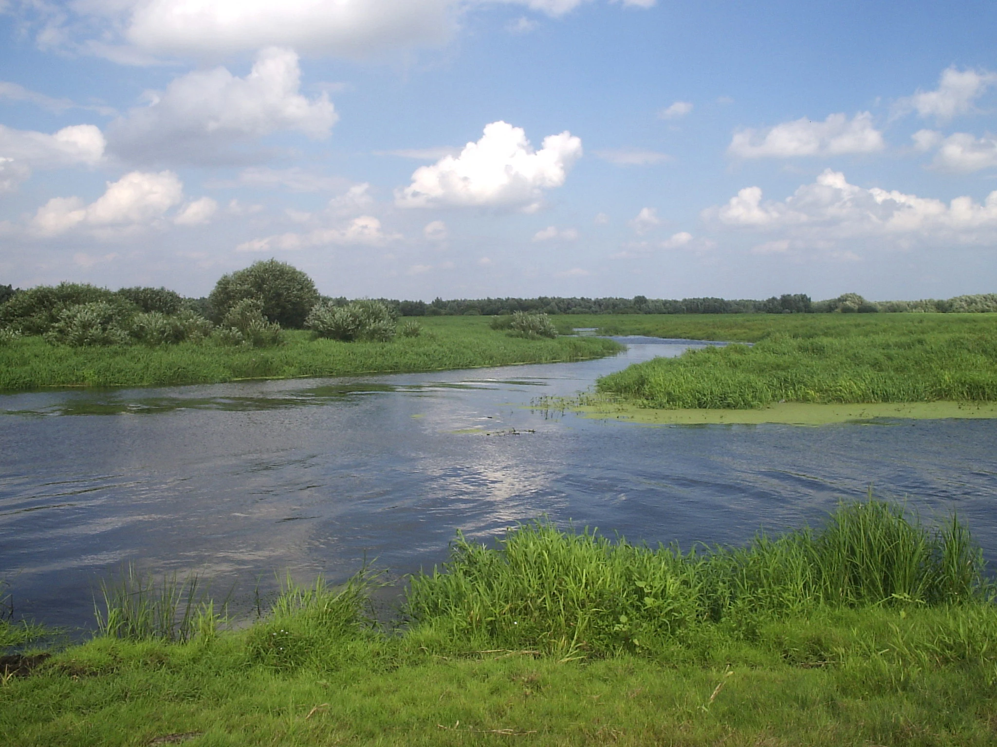
A wide river winding through lush green wetlands and grassy banks under a blue sky with white clouds.
A wide river flowing through green wetlands under a blue sky with scattered clouds in Park Krajobrazowy Ujście Warty.

Park Krajobrazowy Ujście Warty history and protected-area timeline

The Park Krajobrazowy Ujście Warty was established on 18 December 1996 through a regulation of the voivode of the former Gorzów voivodeship. At the time of its creation, it was administered as a single entity within that province. The territory carved out for protection consisted largely of the lower Warta river valley, recognized for its exceptional wetland, meadow, and floodplain habitat values.

Following the 1999 administrative reform of Poland, the voivode-level division into which the park had been placed was reorganized into two new voivodeships, Lubuskie and Zachodniopomorskie. As a result, the park's territory was split between the two new provinces, although the park itself was preserved as a single contiguous protected area. Today, because of this dual administrative location, the park is managed in two parts by the respective nature protection services of each voivodeship.

A major subsequent milestone came in 2001, when a section of approximately 8,000 hectares was separated from the landscape park to form the Ujście Warty National Park. This change reflected the growing recognition of the area's outstanding value for waterbirds and wetland biodiversity, and it elevated the federal-level conservation status of the Warta floodplain. The landscape park itself was then remeasured along corrected boundaries, resulting in its current extent of roughly 19,496 hectares, the great majority of which lies within Lubuskie.

Park Krajobrazowy Ujście Warty landscape and geographic character

The landscape of Park Krajobrazowy Ujście Warty is defined by a wide, flat river-valley setting. The park lies chiefly within the lower Warta valley, with a smaller northern extension along the lower Oder near the villages of Kaleńsko and Porzecze. This is a lowland terrain shaped by millennia of river activity, where floodplain processes continue to influence soils, vegetation, and water levels.

The visual impression is dominated by openness rather than forest. Vast meadows, pastures, and wet grasslands extend across most of the park, often broken only by slow-moving oxbow channels, ditches, and backwaters of the Warta. In the central portion of the park, a fragment of the Kostrzyn Retention Reservoir occupies part of the valley floor, creating large open water surfaces that further diversify the landscape.

Beyond these wet and open zones, forests are a minor but significant component. Only a few percent of the park's total area is forested, but the patches that do exist include ecologically valuable oak stands on floodplain habitat (łęg), a woodland type that thrives on periodically inundated alluvial soils. The overall landscape gives the impression of a working, lightly used agricultural-floodplain ecosystem that has retained its wetland character.

Park Krajobrazowy Ujście Warty ecosystems, habitats, and plant life

Ecologically, Park Krajobrazowy Ujście Warty represents a large complex of lower-river-valley habitats that have become rare in intensively cultivated Central European lowlands. The most characteristic ecosystems are extensive wet meadows and pastures maintained in a semi-natural state, plus an important network of marshes and sedge-dominated wetlands. The vegetation of these marshy areas is largely composed of various sedge communities, reflecting persistent soil saturation and regular flooding influences.

In addition to open wetlands, the park preserves fragments of natural floodplain oak forest (łęg), a habitat type that depends on periodic flooding and that has historically been cleared across much of Poland. These oak stands represent an anchor for forest-dependent species and a genetic reservoir of floodplain woodland.

The mosaic of meadows, marshes, river waters, retention reservoir, and scattered forests creates a habitat complex of high ecological value. It supports both resident wildlife and seasonal visitors, including large numbers of waterbirds and birds of prey that use the open terrain as feeding grounds. The ecological coherence of the Warta valley, of which this park forms a major portion, is what underpins its broader conservation importance.

Park Krajobrazowy Ujście Warty wildlife and species highlights

The park's combination of wetlands, open water, meadows, and floodplain forest supports a rich community of animals, particularly waterbirds and other wetland-dependent species. The openness of the terrain offers important resting and feeding grounds for many migratory and resident birds.

Documented species of note include the European beaver (Castor fiber), a large mammal that depends directly on the river and wetland habitats of the park. Among waterbirds, the area supports breeding or visiting populations of the common merganser (Mergus merganser) and the common goldeneye (Bucephala clangula). White-tailed eagles (Haliaeetus albicilla) and grey herons (Ardea cinerea) occur over the wetlands and open waters, while white storks (Ciconia ciconia) are characteristic of the meadow and pasture landscape. Pine martens (Martes martes) inhabit the forested patches. The wider bird fauna includes many additional waterfowl and wetland species, with the open floodplain also serving as hunting habitat for birds of prey.

Park Krajobrazowy Ujście Warty conservation status and protection priorities

Park Krajobrazowy Ujście Warty plays a major role in conserving a representative segment of Poland's lower-river-valley ecosystems, which are otherwise heavily modified by drainage and agriculture. By protecting extensive meadows, marshes, and fragments of floodplain oak forest, the park helps preserve habitats that have become scarce across the Central European lowlands.

The conservation importance of the area was formally recognized when, in 2001, a portion of the landscape park was elevated to national-park status as Park Narodowy Ujście Warty. This dual-tier protection, landscape park plus national park on closely related land, reflects the high ecological value of the Warta floodplain and its importance for waterbird populations and wetland biodiversity.

Within its boundaries, the park also contains three nature reserves, which strengthen protection for particularly valuable habitats: the Lemierzyce forest reserve, the Dolina Postomii forest reserve, and the Pamięcin steppe reserve. Although the landscape park itself does not have a designated buffer zone (otulina), the combination of landscape-level protection, national-park status on adjacent land, and internal reserves provides a meaningful layered conservation framework for the Warta valley.

Top sights and standout views in Park Krajobrazowy Ujście Warty

The standout features of Park Krajobrazowy Ujście Warty are its enormous open meadows and wetlands, its value as a waterbird refuge, and its place at the heart of one of Poland's most important river-valley conservation complexes. The park complements, and geographically surrounds, the separately designated Ujście Warty National Park, giving the area both strict and landscape-level protection.

The park is also notable for the rarity of its habitat types within the wider Polish landscape. Although forests cover only a small fraction of the area, the riverine oak stands (łęg) found here are a particularly valuable ecological asset, as are the sedge-rich marshes that reflect the natural hydrology of the lower Warta.

Best time to visit Park Krajobrazowy Ujście Warty

The character of Park Krajobrazowy Ujście Warty varies with the seasons in ways typical of large river-valley wetlands. Spring and early summer tend to be the most wildlife-rich periods, when high water levels and active plant growth combine with the breeding season for waterbirds and the peak activity of meadow and marsh fauna. This is also when the open floodplain is at its greenest.

Late summer and early autumn bring lower water levels and active haymaking on the meadows, with large flocks of migratory waterbirds using the pastures, remaining pools, and the Kostrzyn Retention Reservoir as feeding and staging habitat. Winter can also be rewarding for visitors interested in large concentrations of waterfowl, especially when birds gather on the open water surfaces of the reservoir and along unfrozen sections of the Warta.

Monthly climate preview

Long-term temperature and monthly precipitation averages for Park Krajobrazowy Ujscie Warty

Park Krajobrazowy Ujscie Warty Climate Normals and Annual Temperature Rhythm

Historical climate records from 1991 to 2020 document the measured monthly temperature range and precipitation averages at a representative coordinate within Park Krajobrazowy Ujscie Warty. Reviewing the complete twelve-month dataset clarifies long-term meteorological patterns across the protected landscape.
Annual mean9 °C
-1 °C20 °C
Jan-1°
Feb
Mar
Apr
May14°
Jun18°
Jul20°
Aug20°
Sep15°
Oct
Nov
Dec
Warmest month
July

20.3 °C

Coolest month
January

-1.1 °C

Wettest month
July

2.5 mm/day

Driest month
April

1.1 mm/day

Park location guide

Geography guide, regional context, and park location map for Park Krajobrazowy Ujście Warty

Park Krajobrazowy Ujście Warty park geography, regions, and map view in Poland

Understand where Park Krajobrazowy Ujście Warty sits in Poland through a broader geographic reading of the surrounding landscape, nearby location context, and its mapped position within the national park landscape.

How Park Krajobrazowy Ujście Warty fits into Poland

Poland, officially the Republic of Poland, is a Central European country spanning from the Baltic Sea in the north to the Carpathian Mountains in the south. It borders Germany, Czech Republic, Slovakia, Ukraine, Belarus, Lithuania, and Kaliningrad Oblast. The country has a temperate climate, diverse landscapes, and is known for its rich history, cultural heritage, and strong economic position within the EU.

Wider geography shaping Park Krajobrazowy Ujście Warty in Poland

Poland occupies 312,696 km2 in Central Europe, extending from the Baltic Sea coast in the north to the Sudetes and Carpathian Mountains in the south. It borders Germany to the west, Czech Republic and Slovakia to the south, Ukraine and Belarus to the east, and Lithuania and Kaliningrad Oblast to the northeast. The landscape includes lowland plains, uplands, and mountain ranges.

Map view of Park Krajobrazowy Ujście Warty

Use this park location map to pinpoint Park Krajobrazowy Ujście Warty in Poland, understand its exact geographic position, and read its mapped placement within the surrounding landscape more clearly.

Pigeon | © OpenStreetMap contributors
Natural feature types

Browse the Full Collection of Natural Features in Park Krajobrazowy Ujście Warty

Connect with the physical geography of this protected landscape by browsing all documented natural features within the Warta river valley system. Use these mapped data sets to understand the terrain, water bodies, and forest patches that constitute the diverse natural environment of Park Krajobrazowy Ujście Warty.

Visual reference collection highlighting floodplain meadows, riparian oak forests, and wetland habitats.

Park Krajobrazowy Ujście Warty Photos: Landscapes, Scenery, and Wetlands

Visual records capture the wide lowland river valleys, vast seasonal floodplains, and open marshlands defining Park Krajobrazowy Ujście Warty. Photographic documentation provides a detailed look at the protected terrain, waterbird habitats, and alluvial ecosystem character.

A wide river winding through lush green wetlands and grassy banks under a blue sky with white clouds.

Park atlas

Compare adjacent lowland river valleys, wetland reserves, and protected regional landscapes

Explore Parks Near Park Krajobrazowy Ujście Warty and Surrounding Protected Areas

Visitors exploring Park Krajobrazowy Ujście Warty can continue browsing adjacent lowland nature reserves and connected wetland sanctuaries across the river basin. Comparing these nearby protected areas reveals broader regional ecosystems and diverse river valley habitats.
Nature reserveLubusz Voivodeship
Mapped location lies within the park boundary#1 closest

East

Dolina Postomii Nature Reserve: Geography, Protected Forests, and River Valley Mapping

Mapping the protected landscapes of Lubusz Voivodeship

Dolina Postomii Nature Reserve is a significant protected area situated within the river-focused geography of western Poland. The reserve preserves a distinct mosaic of oak-hornbeam forests, acidophilous woodlands, and rich floodplain meadows. This compact landscape offers a window into the natural ecological transition between higher forested terraces and the wetland floor, providing essential habitats for breeding birds and rare beetles within the regional Warta basin.

Area
0.687 km²
Established
2005
Relief
Lowland
Scope
Terrestrial
National parkLubusz Voivodeship
Park boundaries overlap#2 closest

Southeast

Park Narodowy „Ujście Warty” National Park: Regional Geography and Wetland Landscapes

A major protected riparian and floodplain zone in western Poland

Located in the Lubusz Voivodeship, Park Narodowy „Ujście Warty” features an extensive network of wetlands, marshes, and meadows at the Warta and Oder confluence. This atlas entry provides essential geographic context for the park's lowland terrain and riverine ecosystems, which are defined by constant shifts in water levels and seasonal flooding patterns that sustain dense bird populations.

Area
80.74 km²
Established
2001
Visitors
52K annual
Relief
Lowland
Watercolor illustration showing a river winding through rolling green hills with sparse vegetation
National parkLubusz Voivodeship
Park boundaries overlap#3 closest

Southeast

Warta Mouth National Park: A National Park Protecting Vital European Wetlands

Explore mapped protected areas and bird habitats in Lubusz Voivodeship.

Warta Mouth National Park, located in Poland's Lubusz Voivodeship, is a significant protected landscape safeguarding the ecologically rich confluence of the Warta and Oder rivers. As the nation's most recently established national park, it provides critical habitat for a vast array of migratory and breeding bird species within its extensive marshlands and floodplains. This park offers a unique opportunity for atlas-driven exploration of Central European wetland geography and the mapped boundaries of a vital conservation area.

Area
80.38 km²
Established
2001
IUCN
II
Visitors
52K annual
Protected areaLubusz Voivodeship
About 0.2 km away#4 closest

Southeast

Ujście Warty Protected Area: Geography and Landscape Atlas of the Warta River Valley

Natura 2000 wetland and floodplain mapping in Lubusz Voivodeship

Examine the physical geography of Ujście Warty, a major lowland protected area in western Poland. This landscape features a unique layering of river arms, alluvial forests, and dry grasslands, serving as a vital ecological corridor within the broader Oder basin. Use this mapped overview to study the terrain features and structural connectivity of these significant floodplain habitats.

Area
332.15 km²
Water
Water-dominated
Watercolor illustration showing a winding river through a soft, green wetland landscape with distant rolling hills and scattered trees.
Protected areaLubusz Voivodeship
1.4 km away#5 closest

Northeast

Ostoja Witnicko-Dębniańska: Mapped Protected Area and Regional Geography

An extensive mosaic of lowland forest and wetland habitats in Poland

The Ostoja Witnicko-Dębniańska sanctuary serves as a critical protected landscape, defined by its blend of managed forest stands, transitional peatlands, and dystrophic lakes. Positioned along the Warta river valley, this area provides a rich geographic context for understanding the wetland ecosystems of the Lubusz Voivodeship and the surrounding western Polish lowlands.

Area
469.93 km²
Established
2007
Scope
Terrestrial
Water
Major water bodies
Protected landscapeWest Pomeranian Voivodeship
4.5 km away#6 closest

Northwest

Cedynia Landscape Park: Mapped Protected Landscapes and Regional Geography in Poland

Protected mosaic of sandy forests and river valleys

Spanning 308 square kilometers, Cedynia Landscape Park protects a complex transition zone in Poland. The area features the expansive Puszcza Piaskowa pine forests, the hilly moraine relief of the Cedynia Carpathians, and the biodiverse wetlands of the lower Oder River. This protected landscape represents an essential study in lowland ecological gradients and postglacial terrain development within the West Pomeranian Voivodeship.

Area
308.5 km²
Established
1993
Relief
Upland
Climate
Temperate
Nature reserveLubusz Voivodeship
About 6.2 km away#7 closest

East

Rezerwat przyrody Dębowa Góra: Protected Oak and Beech Woodland Geography in Lubusz Voivodeship

Analysis of a near-natural deciduous forest reserve in western Poland.

Rezerwat przyrody Dębowa Góra is a protected fragment of mature deciduous woodland located in Gorzów County. Its landscape preserves essential oak-lime-hornbeam forest stands, providing a glimpse into the natural lowland ecology of the Lubusz Voivodeship through structured active conservation and forest management.

Area
0.113 km²
Established
1995
Relief
Lowland
Climate
Temperate
Watercolor painting showing a winding river through a wetland with trees and hills in the background.
Nature reserveLubusz Voivodeship
About 8.3 km away#8 closest

Southeast

Mokradła Sułowskie Nature Reserve: Mapping Wetland Protected Areas in Lubusz Voivodeship

A comprehensive geographic atlas of Polish peatland and forest marsh habitats

The Mokradła Sułowskie nature reserve protects a vital cluster of eutrophic lakes and waterlogged mires in western Poland. This atlas entry provides a detailed look at its unique landscape, where divided northern and southern sections showcase diverse stages of marshland succession and regional biodiversity within the broader Lubusz Voivodeship.

Area
0.451 km²
Established
1990
Water
Water-dominated

Common questions about visiting, size, designation, and location context for Park Krajobrazowy Ujście Warty

Park Krajobrazowy Ujście Warty FAQs for park facts, access, geography, and protected area context

Find quick answers about Park Krajobrazowy Ujście Warty, including protected-area facts, park geography, trail and visitor context, and how the park fits into its surrounding country and regional landscape.
MoriAtlas Explorer

Continue Your Protected Areas Search Across the Global Atlas

Deepen your exploration by continuing the structured search for national parks and protected areas worldwide. Utilize the comprehensive filtering capabilities to compare different conservation landscapes and refine your understanding of global park geography. Discover more about the distribution and characteristics of protected natural areas.

Global natural geography