Mori Atlas logo
Protected areaPodziemia Tarnogórsko-Bytomskie

Mapping the historic silver and lead mining network beneath the Upper Silesian terrain

Podziemia Tarnogórsko-Bytomskie: A Protected Industrial Heritage and Subterranean Landscape

(Tarnowskie Góry – podziemia zabytkowej Kopalni Rud Srebronośnych oraz Sztolni Czarnego Pstręga)

Podziemia Tarnogórsko-Bytomskie represents a unique convergence of industrial heritage and ecological conservation within Poland. This extensive system of medieval and early modern tunnels, adits, and shafts spans over 300 kilometers beneath the Garb Tarnogórski ridge. Recognized as both a historic monument and a critical Natura 2000 bat hibernation site, the area offers a deep perspective on the intersection of human mining labor and specialized subterranean ecosystems.

UNESCO World Heritage Siteindustrial heritagehistoric silver mineunderground workingslead and zinc miningUpper Silesia

Podziemia Tarnogórsko-Bytomskie

Protected area

Park overview

Structured park overview, official facts, and landscape profile for Podziemia Tarnogórsko-Bytomskie

Podziemia Tarnogórsko-Bytomskie park facts, protected area profile, and essential visitor context

Review the core facts for Podziemia Tarnogórsko-Bytomskie, including designation, size, terrain, visitor scale, habitats, and operating context in one park-focused overview.

About Podziemia Tarnogórsko-Bytomskie

Podziemia Tarnogórsko-Bytomskie is a vast and historically layered underground landscape that records more than seven centuries of metal mining in the Garb Tarnogórski region of Upper Silesia. Located beneath Tarnowskie Góry and nearby communities in the Silesian Voivodeship of southern Poland, the surviving workings form one of the largest connected mine systems in Europe, stretching across hundreds of kilometers of adits, shafts, galleries, and chambers. They are the physical residue of an industry that, at its peak, made Tarnowskie Góry one of the most productive silver and lead mining centers on the continent.

The mining heritage visible in the underground network reflects the broader evolution of European ore extraction. Early workings followed shallow silver-bearing lead ores, with miners driving small square or round shafts rarely more than a meter in diameter. As the easily reached deposits were exhausted and then rediscovered in the mid-sixteenth century, deeper extraction pushed the industry into a new era, requiring sophisticated systems of adits and pumping works to control inflowing groundwater. The preserved equipment and engineered structures that remain in the workings document both this medieval beginning and the later technological response to flooding and ventilation, illustrating how the survival of a mine was as much a feat of water engineering as of ore extraction.

Beyond its role as an industrial monument, the system has acquired a powerful second identity as a wildlife refuge. The cool, stable, and largely undisturbed underground passages have become Upper Silesia's most important hibernation site for bats, including rare species protected under European Union nature law. This dual significance has shaped the site's modern institutional profile: it was entered into the Polish register of historical monuments in 1955 and again in 1966, designated a Polish Monument of History in 2004, recognized as a Natura 2000 area because of its bat populations, and ultimately inscribed on the UNESCO World Heritage List in 2017. The result is a place where centuries of human industrial activity and the ecological heritage of the underground environment are managed together as a single cultural and natural resource.

Quick facts and research context for Podziemia Tarnogórsko-Bytomskie

Podziemia Tarnogórsko-Bytomskie is a connected system of medieval and early modern silver, lead, and zinc mine workings located beneath Tarnowskie Góry and adjacent areas in the Silesian Voivodeship of southern Poland. The underground network exceeds 300 kilometers in cumulative length across adits, shafts, galleries, and chambers, making it one of the most extensive preserved mining complexes of its kind in Europe. It was inscribed on the UNESCO World Heritage List in 2017 under criteria I, II, and IV, and previously designated a Polish Monument of History in 2004.

The same underground environment has acquired a parallel ecological importance: the site is protected as the Natura 2000 refuge Podziemia Tarnogórsko-Bytomskie, covering roughly 3,490 hectares, primarily because the workings host hibernating bat populations, including species listed under Annex II of the EU Habitats Directive. The combination of industrial archaeological significance and bat conservation gives the place a distinctive dual identity among European heritage sites.

Protection and recognition

Documented terrestrial protection scope, designation history, and Natura 2000 records

Podziemia Tarnogórsko-Bytomskie Protection Status and Recognition Data

Podziemia Tarnogórsko-Bytomskie holds a documented terrestrial protection status established in 2017 with official Natura 2000 recognition sources. Conservation researchers consult these designated boundaries to track administrative history and international protection frameworks.
Park context

Deeper park guide and search-rich context for Podziemia Tarnogórsko-Bytomskie

Podziemia Tarnogórsko-Bytomskie history, landscape, wildlife, and travel context

Explore Podziemia Tarnogórsko-Bytomskie through its history, landscape character, ecosystems, wildlife, conservation priorities, cultural context, and seasonal travel timing in a structured park guide built for atlas discovery and search intent.

Why Podziemia Tarnogórsko-Bytomskie stands out

The site is best known for the sheer scale and continuity of its preserved underground workings, which document silver and lead ore mining from the twelfth century onward. Its tunnels, adits, shafts, and chambers, more than 300 kilometers in total length, illustrate both medieval extraction techniques and later innovations in water management that allowed deep workings to remain operational. Equally important to its identity is the way the abandoned mine has become one of Upper Silesia's most significant bat hibernation sites. The combination of UNESCO-listed industrial heritage and a Natura 2000 bat refuge makes Podziemia Tarnogórsko-Bytomskie a notable example of how a historic mining landscape can simultaneously serve cultural heritage and ecological protection functions.
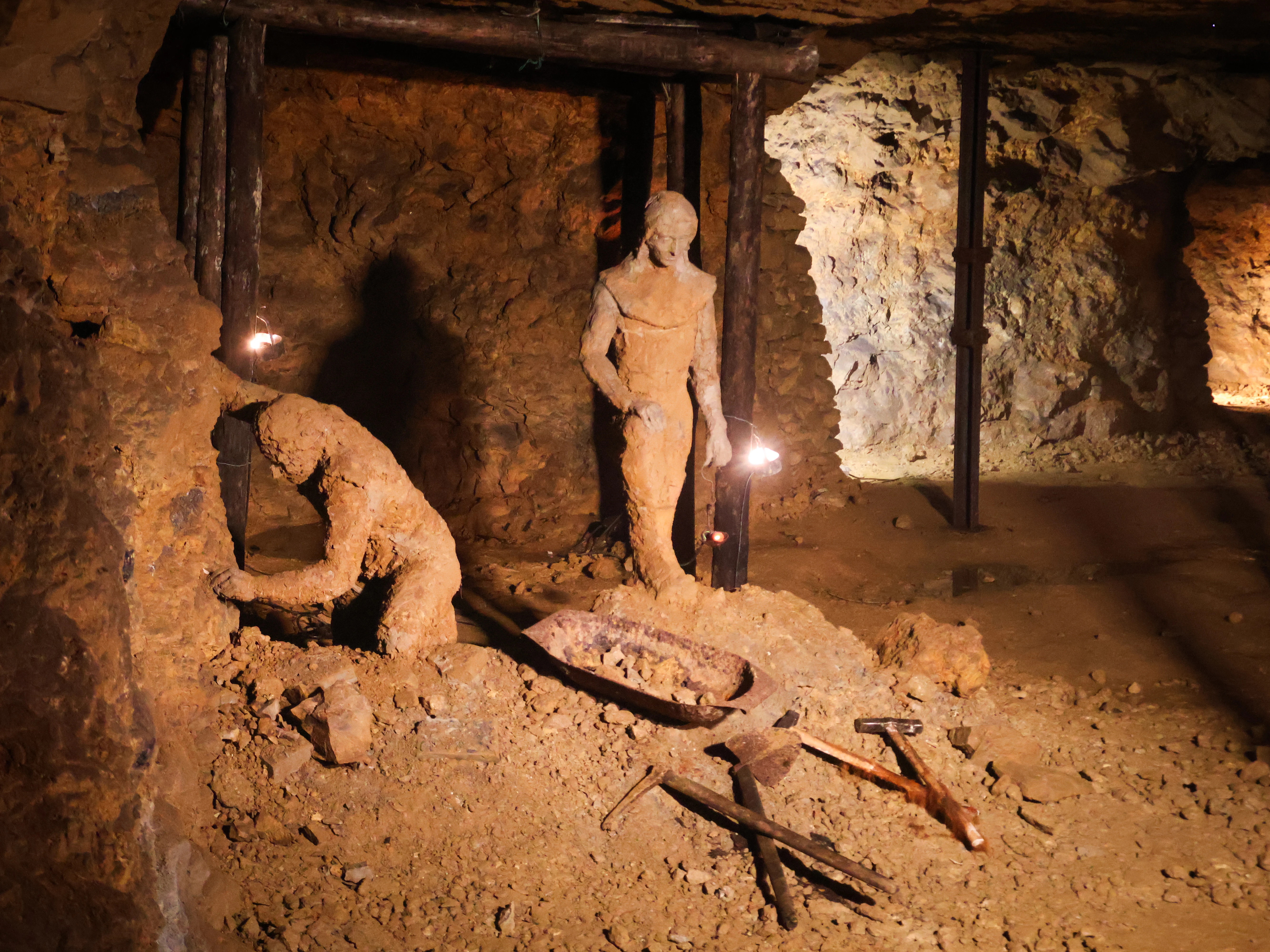
A dimly lit underground mine tunnel featuring two life-sized clay-colored figures depicting miners at work; one figure is bent over working the rock wall, while the other stands nearby, with period tools and a cart in the foreground.
Historical exhibit featuring figures representing mining work inside the tunnels of Podziemia Tarnogórsko-Bytomskie.

Podziemia Tarnogórsko-Bytomskie history and protected-area timeline

The documented history of Podziemia Tarnogórsko-Bytomskie reaches back to the twelfth century, when the first references to ore extraction in the Tarnowskie Góry area appear in a papal bull issued by Innocent II in 1136. By 1247, written records describe active mining of galena, or lead ore, near the village of Repty, placing the Tarnowskie Góry region among the oldest mining centers in Europe. In these early centuries, excavation was carried out through small shafts, generally square or round in cross-section, with diameters rarely exceeding one meter. Because the workings were prone to flooding, activity concentrated on higher ground, and traces of medieval mining can still be found on local elevations such as Sucha Góra and Srebrna Góra.

Around the turn of the fifteenth and sixteenth centuries, the industry experienced a temporary decline, likely tied to the exhaustion of shallow ore deposits. A new phase began in the mid-sixteenth century with the accidental discovery of a galena outcrop, ushering in the most prosperous period of Tarnowskie Góry mining and the rapid growth of the town itself. Between 1556 and 1559, mining activity is estimated to have produced as many as 2,500 new shafts in a single year. Average annual lead output from local ores reached roughly 600 to 800 tons, and at the height of production may have climbed to about 3,000 tons. The ore was unusually rich in silver, with reported silver contents ranging from a small fraction of a percent up to roughly three percent, and occasional finds of native silver are recorded.

The mining tradition continued in evolving forms into the twentieth century, leaving behind the multi-layered network of workings recognized today. The site was entered into the Polish register of historical monuments in 1955 and re-registered in 1966. In 2004, a Presidential regulation formally recognized Tarnowskie Góry; the underground of the Historic Silver Ore Mine and the Black Trout Adit as a Monument of History. The international recognition that would define its modern profile came on July 9, 2017, when, during the forty-first session of the World Heritage Committee held in Kraków, Podziemia Tarnogórsko-Bytomskie was inscribed on the UNESCO World Heritage List under criteria I, II, and IV.

Podziemia Tarnogórsko-Bytomskie landscape and geographic character

The protected entity is not a surface landscape in the conventional sense but a vast underground terrain shaped by human labor. The subterranean environment beneath the Garb Tarnogórski ridge consists of an interconnected web of horizontal adits, inclined and vertical shafts, narrow mining galleries called chodniki, larger excavated chambers, and irregular stopes known as wyrobiska and wybierki. The cumulative length of this network exceeds 300 kilometers, creating an extraordinarily extensive and labyrinthine substrate beneath the Silesian countryside.

At the surface, the mining heritage is closely tied to the gently rolling topography of the Garb Tarnogórski, a low ridge in Upper Silesia whose modest elevations, including Sucha Góra and Srebrna Góra, still preserve traces of medieval shaft workings on their slopes. The contrast between the subdued surface relief and the sheer density of passages below gives the site a layered geographic character, where the everyday landscape of fields, forests, and small towns sits directly atop one of Europe's densest networks of preserved mine workings. Drainage and ventilation features at the connection points between the surface and the underground, including the openings in the southern part of the former Blachówka workings used by bats to move between the tunnels and the outside world, link the surface and subterranean realms into a single integrated system.

Podziemia Tarnogórsko-Bytomskie ecosystems, habitats, and plant life

Ecologically, the underground workings function as a unique, human-made habitat system at the boundary between industrial space and natural refuge. The constant temperature, humidity, and darkness of the deeper galleries and adits reproduce conditions otherwise rare in the Upper Silesian landscape, creating environments that support highly specialized communities. The extensive network provides undisturbed roosting and hibernation space on a scale unmatched elsewhere in the region, allowing the workings to function as a true ecological island beneath an otherwise densely populated and industrialized terrain.

The site's ecological profile is integrated into the broader Natura 2000 network through the refuge Podziemia Tarnogórsko-Bytomskie, which covers roughly 3,490 hectares. The protected natural values of the area are fundamentally linked to the integrity of the underground environment itself, including the preservation of suitable microclimatic conditions and the maintenance of safe access routes and ventilation openings that connect the deeper workings to the surface.

Podziemia Tarnogórsko-Bytomskie wildlife and species highlights

Podziemia Tarnogórsko-Bytomskie is most notable for the richness of its bat fauna, which uses the abandoned mine workings as one of the largest hibernation sites in Upper Silesia. Researchers and conservationists working in the underground system have documented ten species of bats, including the greater mouse-eared bat (Myotis myotis) and Bechstein's bat (Myotis bechsteinii), both of which are among the species listed under Annex II of the European Union Habitats Directive.

The bat populations rely heavily on the structural features of the mine. In the southern part of the former Blachówka workings, openings in the exploitation wall serve simultaneously as movement routes for bats moving between the underground environment and the surface and as ventilation pathways for the larger corridor system. This functional overlap illustrates how a feature designed historically for industrial water and air management has become an ecological asset of regional significance.

Podziemia Tarnogórsko-Bytomskie conservation status and protection priorities

Podziemia Tarnogórsko-Bytomskie is protected under multiple overlapping layers of cultural and natural heritage law. On the cultural side, the underground works were entered into the Polish register of historical monuments in 1955 and re-registered in 1966, and in 2004 the site was designated a Monument of History. The most prominent international recognition came in 2017, when the site was inscribed on the UNESCO World Heritage List under criteria I, II, and IV, acknowledging its outstanding universal value as a historic mining landscape and as a testimony to technological and social developments connected with ore extraction and underground water management.

Parallel to this cultural protection, the site is also a designated European ecological refuge. It was designated as the Natura 2000 site Podziemia Tarnogórsko-Bytomskie, with the code PLH240003, because of the presence of bat species listed under Annex II of the EU Habitats Directive. This convergence of industrial heritage protection and species-based natural conservation gives the place a distinctive significance: ensuring the long-term survival of a working medieval and early modern mine system is inseparable from maintaining the conditions that allow rare hibernating bats to continue using the tunnels.

Podziemia Tarnogórsko-Bytomskie cultural meaning and human context

The site forms a core element of the cultural identity of Tarnowskie Góry and the surrounding Upper Silesian communities whose history has been shaped almost continuously by mining. From the medieval period onward, the rhythms of work, settlement, and civic life in the region were organized around the extraction of silver-bearing lead ores, and the prosperity of Tarnowskie Góry itself was built on this industry during the great expansion of the sixteenth century. The preserved workings are therefore not only a technical record of mining but also a tangible expression of the regional heritage of the Garb Tarnogórski.

The modern recognition of the site has been driven in significant part by local civic initiatives, including efforts by the Stowarzyszenie Miłośników Ziemi Tarnogórskiej, the Tarnowskie Góry Land Lovers' Association, whose request to Poland's Ministry of Culture and National Heritage ultimately led to the nomination and successful UNESCO inscription. This grassroots involvement illustrates how the underground landscape continues to shape the cultural self-understanding of a community that defines itself, in part, through the long memory of its mining past.

Top sights and standout views in Podziemia Tarnogórsko-Bytomskie

The defining strengths of Podziemia Tarnogórsko-Bytomskie lie in the combination of its extraordinary underground extent, the depth of its historical record, and the dual cultural and natural importance of its protected status. With more than 300 kilometers of surviving adits, shafts, galleries, and chambers, the site ranks among the largest preserved medieval and early modern mine networks in Europe and offers an unusually complete picture of how ore extraction evolved from rudimentary shafts to engineered systems with elaborate water management.

Equally distinctive is the way the site unites two normally separate protection logics. The same tunnels that document eight centuries of silver and lead mining are also recognized as Upper Silesia's most important bat hibernation area, with ten recorded bat species including Annex II taxa. This overlap of UNESCO World Heritage, Polish Monument of History, and Natura 2000 status makes the place a particularly notable example of integrated heritage management in industrial landscapes.

Best time to visit Podziemia Tarnogórsko-Bytomskie

As an underground site, Podziemia Tarnogórsko-Bytomskie is largely insulated from seasonal surface weather, and access to show workings such as the Historic Silver Mine and the Black Trout Adit is maintained in conditions designed for visitor comfort year-round. The most pleasant periods for combining an underground visit with exploration of the surrounding Above-Ground Silesian landscape are late spring through early autumn, when the rolling terrain of the Garb Tarnogórski and nearby nature areas are at their most accessible and visually expressive.

Winter visits are also characteristic of the site's identity, because this is the season when the underground workings serve their ecological function as a major bat hibernation refuge. Visitors interested in this dimension of the site may find the colder months particularly meaningful, while still experiencing the stable interior climate of the tunnels themselves. Choosing a visit window is therefore less about avoiding difficult seasons and more about whether the traveler wishes to emphasize the historical, scenic, or ecological character of the place.


Monthly climate preview

Long-term temperature ranges and monthly precipitation averages for the park coordinate

Podziemia Tarnogórsko-Bytomskie Climate Normals and Annual Weather Patterns

Representative measurements from 1991 to 2020 record average monthly temperatures ranging from negative values in winter months to nearly twenty degrees Celsius in midyear, alongside recorded daily precipitation rates. Examining the full twelve-month profile provides complete context on historical climate normals and monthly variations at this protected location.
Annual mean8 °C
-3 °C20 °C
Jan-3°
Feb-2°
Mar
Apr
May14°
Jun18°
Jul20°
Aug20°
Sep14°
Oct
Nov
Dec-2°
Warmest month
July

20 °C

Coolest month
January

-3.3 °C

Wettest month
July

2.9 mm/day

Driest month
January

1.5 mm/day

Park location guide

Geography guide, regional context, and park location map for Podziemia Tarnogórsko-Bytomskie

Podziemia Tarnogórsko-Bytomskie park geography, regions, and map view in Poland

Understand where Podziemia Tarnogórsko-Bytomskie sits in Poland through a broader geographic reading of the surrounding landscape, nearby location context, and its mapped position within the national park landscape.

How Podziemia Tarnogórsko-Bytomskie fits into Poland

Poland, officially the Republic of Poland, is a Central European country spanning from the Baltic Sea in the north to the Carpathian Mountains in the south. It borders Germany, Czech Republic, Slovakia, Ukraine, Belarus, Lithuania, and Kaliningrad Oblast. The country has a temperate climate, diverse landscapes, and is known for its rich history, cultural heritage, and strong economic position within the EU.

Wider geography shaping Podziemia Tarnogórsko-Bytomskie in Poland

Poland occupies 312,696 km2 in Central Europe, extending from the Baltic Sea coast in the north to the Sudetes and Carpathian Mountains in the south. It borders Germany to the west, Czech Republic and Slovakia to the south, Ukraine and Belarus to the east, and Lithuania and Kaliningrad Oblast to the northeast. The landscape includes lowland plains, uplands, and mountain ranges.

Map view of Podziemia Tarnogórsko-Bytomskie

Use this park location map to pinpoint Podziemia Tarnogórsko-Bytomskie in Poland, understand its exact geographic position, and read its mapped placement within the surrounding landscape more clearly.

Pigeon | © OpenStreetMap contributors
Recorded earthquake history

View the Historical Earthquake and Seismic Activity Catalogue

Explore the structured database of seismic events documented in the region surrounding Podziemia Tarnogórsko-Bytomskie. MoriAtlas provides this catalogue to support geographic understanding of regional seismic patterns and historical activity recorded near these extensive underground workings.

Podziemia Tarnogórsko-Bytomskie Earthquake History

Catalogued events

382 events

Strongest magnitude

Magnitude 5.1

Most recent event

Jan 27, 2025

This history includes earthquakes recorded inside the park or within 50 km of its borders

Visual exploration of subterranean mining tunnels, stone chambers, and protected habitats

Podziemia Tarnogórsko-Bytomskie Photos and Underground Landscape Scenery

Visual documentation reveals the extensive underground terrain, historic adits, and complex stone chambers that define Podziemia Tarnogórsko-Bytomskie. Examining these protected spaces provides clear insight into the subterranean architecture and ecological habitats preserved across the region.

A dimly lit underground mine tunnel featuring two life-sized clay-colored figures depicting miners at work; one figure is bent over working the rock wall, while the other stands nearby, with period tools and a cart in the foreground.

Park atlas

Compare regional park geography and connected conservation landscapes across Upper Silesia

Explore Parks Near Podziemia Tarnogórsko-Bytomskie and Surrounding Protected Areas

Browsing other protected areas near Podziemia Tarnogórsko-Bytomskie reveals the broader environmental and industrial heritage contexts of the surrounding region. Comparing adjacent terrain helps trace the wider geographic distribution of historic reserves and regional park networks.
A soft, light-toned watercolor painting of a meandering river through a gentle, rolling landscape with trees and soft hills in the distance.
Protected landscapeSilesian Voivodeship
About 1.9 km away#1 closest

South

Miechowicka Ostoja Leśna Protected Landscape and Silesian Upland Forest Geography

An industrial-era woodland refuge and arboretum.

Located in the Silesian Voivodeship, this protected landscape preserves a rare blend of native broadleaf forest and exotic arboretum plantings. The area stands as a testament to regional forest recovery, where historic mining heaps and sunken shafts have been integrated into a mosaic of ponds, clearings, and dendrological trails.

Area
3.056 km²
Established
2012
Relief
Lowland
Scope
Terrestrial
Watercolor painting of a lush green landscape with trees, rolling hills, and a water feature in a soft pastel palette.
Protected landscapeSilesian Voivodeship
23 km away#2 closest

Southwest

Park Krajobrazowy Cysterskie Kompozycje Krajobrazowe Rud Wielkich: A Silesian Protected Area

Riverine landscapes, forest corridors, and historic Cistercian pond networks

Situated in the Silesian Voivodeship, this protected landscape encompasses a significant portion of the Upper Oder basin. Its geography is characterized by a balance of managed forest, agricultural fields, and an intricate lattice of fishponds. These features provide critical refuge for waterbirds and preserve riparian woodland patterns that reflect centuries of deliberate landscape transformation by the Cistercian order.

Area
493.87 km²
Established
1993
Relief
Lowland
Climate
Temperate
Protected areaSilesian Voivodeship
32 km away#3 closest

East

Łąki w Sławkowie Protected Area: Silesian Voivodeship Landscape and Map Analysis

Mapping rare fen and meadow habitats in southern Poland

Łąki w Sławkowie is a crucial protected habitat area situated west of Sławków. Its landscape consists of four connected enclaves characterized by wet meadow communities and calcareous fens. This data-driven overview highlights the site's hydrological and ecological significance within the broader Silesian Voivodeship and Poland's Natura 2000 network.

Area
0.51 km²
Relief
Lowland
Scope
Terrestrial
Water
Minor water
Nature reserveSilesian Voivodeship
38 km away#4 closest

East

Ostoja Środkowojurajska Nature Reserve: Protected Area Geography and Habitat Mapping

Regional karst terrain and protected beech forest mosaic

Analyze the geographic structure of Ostoja Środkowojurajska, a vital Natura 2000 site in the Silesian Voivodeship. This protected area features a unique concentration of inland dunes, rocky limestone outcrops, and multiple forest types. Explore the site to understand its role in regional conservation and its varied, karst-influenced physical geography.

Area
57.676 km²
Established
2009
Relief
Upland
Climate
Temperate
A soft watercolor painting of a rolling landscape featuring light-colored limestone cliffs, green hills, and a winding path, rendered in pale pastel tones.
Nature reserveSilesian Voivodeship
40 km away#5 closest

Northeast

Ostoja Olsztyńsko-Mirowska: A Detailed Map and Geographic Overview of the Protected Reserve

Karst limestone formations and diverse forest habitats in Silesian Voivodeship.

Ostoja Olsztyńsko-Mirowska stands as a centerpiece of the Częstochowa Upland, characterized by its dramatic mogotes, caves, and sheltered xerothermic grasslands. This atlas-focused entry details the area's topographic complexity, ranging from the wooded ridges of Sokole Góry to the historic limestone spurs housing medieval ruins. Uncover the ecological dynamics of this protected landscape where beech forest stands and rare cave systems form a critical regional biodiversity network.

Area
22.109 km²
Established
2008
Relief
Upland
Climate
Temperate
Watercolor painting depicting a soft-focus landscape with light sandy ground in the foreground, a line of green trees in the midground, and layered rolling hills in the background.
Protected areaMałopolskie
41 km away#6 closest

East

Pustynia Błędowska: Protected Inland Sand Dunes and Geographic Map Context in Poland

An expansive shifting sand landscape within the Małopolskie region

Pustynia Błędowska stands as a unique protected site in Poland, defined by its extensive quartz sand sheets and inland dune formations. This landscape offers a compelling look at the intersection of anthropogenic history and ecological restoration, supporting rare sand-dwelling flora and invertebrates within a specialized grassland habitat.

Area
33 km²
Established
2004
Relief
Upland
Climate
Temperate
A watercolor painting of a serene landscape showing a pond, green trees, and low hills in the background.
Nature reserveJaworzno
About 41 km away#7 closest

Southeast

Rezerwat przyrody Dolina Żabnika: Protected Stream Valley and Wetland Map in Jaworzno

A dense ecological sanctuary within the Silesian Highlands

Rezerwat przyrody Dolina Żabnika protects a rare concentration of aquatic and peat-forming habitats along the Żabnik stream. This nature reserve offers a distinct look at transitional bog ecosystems and pine forest integration in southern Poland, providing a mapped window into the complex drainage geography and preserved biodiversity of the Silesian Voivodeship.

Area
0.48 km²
Established
1996
Relief
Lowland
Climate
Temperate
Protected areaSilesian Voivodeship
42 km away#8 closest

Northeast

Ostoja Złotopotocka: Mapping the Protected Habitats and Limestone Geography of Silesian Voivodeship

Natura 2000 protected zone in southern Poland

Ostoja Złotopotocka encompasses a rich mosaic of natural habitats across the Częstochowa Upland. From the calcareous rock faces and deep karst caves to the expansive beechwood forests and inland sand dunes, this area serves as a primary site for ecological conservation. Use this resource to understand the complex terrain, boundary layout, and structural diversity that define this protected landscape within the Polish region.

Area
27.48 km²
Relief
Upland
Climate
Temperate
Access
Access unknown

Common questions about visiting, size, designation, and location context for Podziemia Tarnogórsko-Bytomskie

Podziemia Tarnogórsko-Bytomskie FAQs for park facts, access, geography, and protected area context

Find quick answers about Podziemia Tarnogórsko-Bytomskie, including protected-area facts, park geography, trail and visitor context, and how the park fits into its surrounding country and regional landscape.
MoriAtlas Explorer

Continue Your Protected Areas Search Across the Global Atlas

Deepen your exploration by continuing the structured search for national parks and protected areas worldwide. Utilize the comprehensive filtering capabilities to compare different conservation landscapes and refine your understanding of global park geography. Discover more about the distribution and characteristics of protected natural areas.

Global natural geography