
Mori Atlas logo
Nature reservePolanský les

Understanding the mapped landscape boundaries and ecological significance of this Moravian floodplain relic.

Polanský les Nature Reserve: A Detailed Geographic Atlas of the Oder River Floodplain Woodlands

(Přírodní rezervace Polanský les)

Polanský les serves as a significant nature reserve protecting a rare fragment of hard floodplain forest situated on the left bank of the Oder River. Located within the northern outskirts of Ostrava in the Moravskoslezský kraj, this site represents a critical botanical habitat known for its relic snowdrop populations and ancient broadleaf canopy. The terrain offers a unique intersection of alluvial geology, straddling the transition zone between the Bohemian Massif and the Outer Western Carpathians.

floodplain foresthardwood floodplainsnowdrop habitatbroadleaf forestprotected landscaperiver forest
An illustration in a flat design style showing a lush green forest foreground with a fallen log, looking out toward distant rocky mountain cliffs and a cascading waterfall under a bright sky.

Polanský les

Nature reserve

Park overview

Structured park overview, official facts, and landscape profile for Polanský les

Polanský les park facts, protected area profile, and essential visitor context

Review the core facts for Polanský les, including designation, size, terrain, visitor scale, habitats, and operating context in one park-focused overview.

About Polanský les

Polanský les is a compact nature reserve on the left bank of the Oder River within the city of Ostrava. Although it lies close to dense urban and industrial surroundings, it preserves one of the rare remaining fragments of traditional floodplain forest along the Oder, a landscape type that has been heavily reduced across the region.

The reserve belongs to the wider Poodří protected landscape area network, marking the northern terminus of this protected region. Its position on the geological boundary between the older Bohemian Massif and the younger Outer Western Carpathians adds a layer of geological interest to its primarily ecological significance. Administratively, it is managed under the Poodří Protected Landscape Area office of the Czech Agency for Nature Conservation and Landscape Protection.

Beyond its snowdrop population, Polanský les is valued for the structural diversity of its broadleaf forest, a result of long-standing non-intervention management. Old trees, fallen wood, and a humid understorey combine to create habitat conditions that support rare woodland bats, cavity-nesting birds, amphibians, and a rich spring flora. The reserve thus serves as both a botanical sanctuary and a small but important refuge for forest-dependent fauna within a heavily modified industrial region.

Quick facts and research context for Polanský les

Polanský les is a Czech nature reserve (přírodní rezervace) lying on the left bank of the Oder River in the Ostrava-město district of the Moravian-Silesian Region. The reserve has been protected since 17 December 1970, when it was declared by the former Ministry of Culture of the Czechoslovak Socialist Republic.

Protection and recognition

Documented terrestrial protection scope and conservation status details

Polanský les Protection Status and International Recognition Data

Polanský les maintains a documented terrestrial protection scope without imported international recognition sources. Conservation records track management frameworks and designated status for geographical analysis.

Protection details

Protection scope
Terrestrial
Transboundary protection
No
Park context

Deeper park guide and search-rich context for Polanský les

Polanský les history, landscape, wildlife, and travel context

Explore Polanský les through its history, landscape character, ecosystems, wildlife, conservation priorities, cultural context, and seasonal travel timing in a structured park guide built for atlas discovery and search intent.

Why Polanský les stands out

The reserve is best known for protecting one of the characteristic relic populations of snowdrops (Galanthus nivalis) in the Poodří floodplain landscape, together with an unusually well-preserved fragment of hard floodplain forest dominated by ash, oak, maple, and linden.
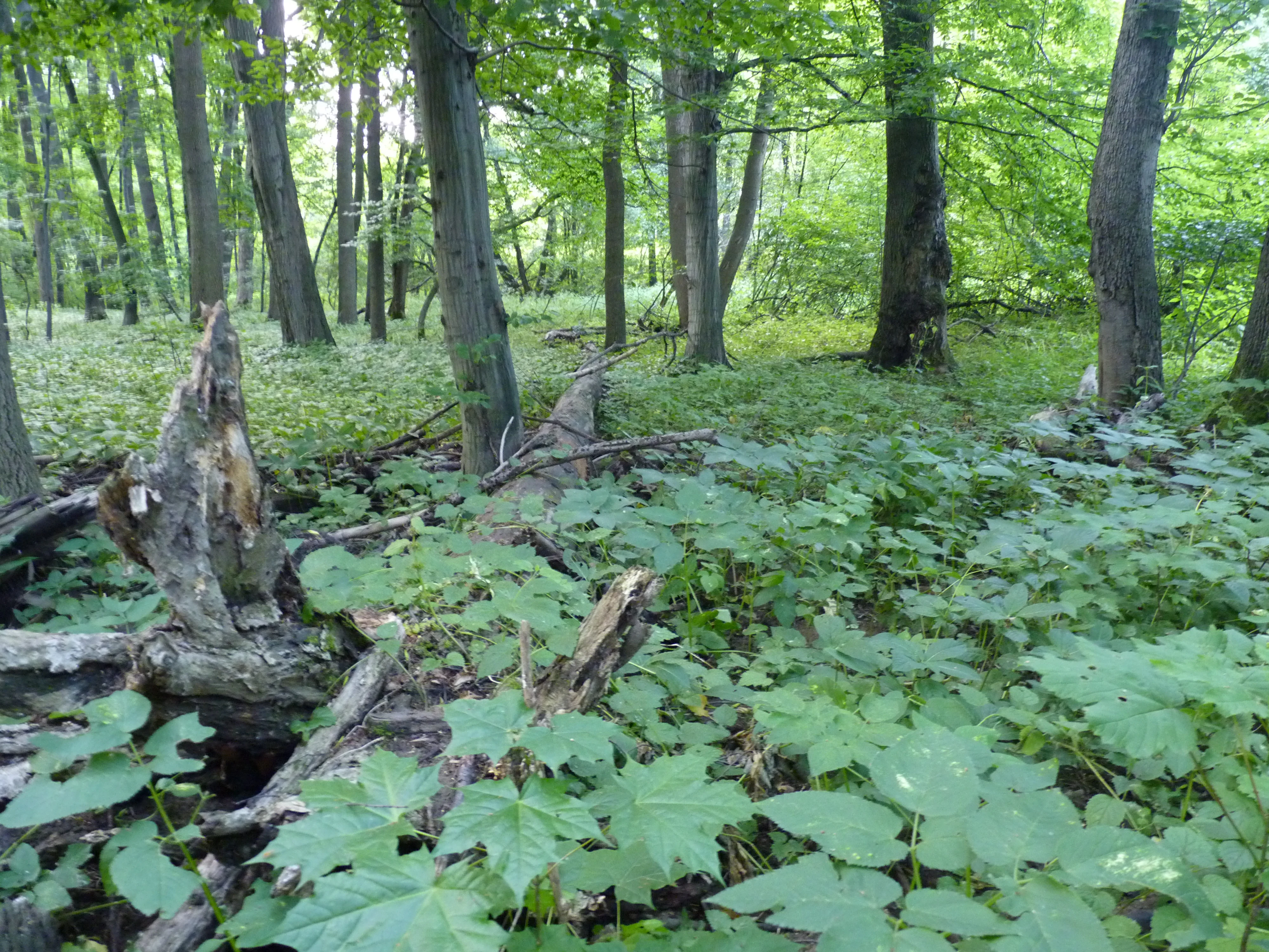
A view into a dense, green deciduous forest featuring mature tree trunks, low-lying ground vegetation, and fallen deadwood logs on the forest floor.
A lush, green interior of the Polanský les floodplain forest.

Polanský les history and protected-area timeline

Polanský les was officially declared a nature reserve on 17 December 1970 by the Ministry of Culture of the Czechoslovak Socialist Republic. Since then, it has been managed as a strictly protected natural area, with particular attention to the preservation of its floodplain forest character and its snowdrop population.

Its current management approach emphasizes non-intervention forestry, with fallen and dead wood deliberately retained on site to support saproxylic insects and fungi. Visitors are restricted to marked paths, and non-native tree species such as black locust (Robinia pseudacacia) are progressively removed to maintain the integrity of the native broadleaf community.

Polanský les landscape and geographic character

Polanský les occupies a low-elevation stretch of the Oder River floodplain, with the terrain lying only a few metres above the river. The site is essentially flat, shaped by the flood dynamics of the Oder, and forms a small wooded belt along the left bank of the river.

Geologically, the reserve sits at a notable boundary between the Bohemian Massif to the west and the Outer Western Carpathians to the east, making the underlying geology geologically transitional rather than uniform. The visible surface, however, is dominated by alluvial floodplain deposits and the closed canopy of the forest itself, with seasonal flooding shaping soil conditions and understorey composition.

Polanský les ecosystems, habitats, and plant life

The reserve's core ecosystem is a hard floodplain forest, a lužní les, composed mainly of mature mixed broadleaf stands. Common canopy trees include ash (Fraxinus excelsior) and pedunculate oak (Quercus robur), alongside sycamore maple, Norway maple, small-leaved and large-leaved linden, and hornbeam. Wych elm and European white elm occur more sparsely, while bird cherry forms the most abundant shrub layer.

The forest floor is particularly rich in spring, with extensive carpets of snowdrops (Galanthus nivalis) and wild garlic (Allium ursinum). Other notable woodland plants include Martagon lily (Lilium martagon) and the violet helleborine (Epipactis purpurata), both protected or threatened in the Czech context.

Polanský les wildlife and species highlights

Wildlife in Polanský les reflects the value of old, structurally diverse broadleaf forest. Bats are a particular focus of conservation interest, with nine bat species recorded, including Leisler's bat and Daubenton's bat. The reserve's mature trees and cavities provide important roosting and foraging habitat for these woodland specialists.

The site's birdlife includes typical floodplain and mature-forest species, such as collared flycatcher, goosander, and middle spotted woodpecker. The common kingfisher is also present along the Oder's waters. Among amphibians and reptiles, the reserve supports threatened species including smooth newt and European tree frog.

Polanský les conservation status and protection priorities

Polanský les is protected as a nature reserve (přírodní rezervace), a category corresponding broadly to IUCN Category IV, focused on the conservation of a particular species or habitat. Its designation in 1970 specifically targeted the protection of a floodplain forest fragment and its snowdrop population, treated as a relic within the Poodří floodplain landscape.

Ongoing management emphasizes letting the forest develop with minimal active forestry intervention. Dead and decaying wood is retained as habitat for xylophagous and saproxylic insects and for fungi, while invasive non-native trees such as black locust are gradually eliminated. The site thus functions as a small but actively conserved reference area for the wider Poodří protected landscape.

Top sights and standout views in Polanský les

Polanský les offers a rare chance to see a surviving hard floodplain forest on the Oder within the Ostrava urban area, complete with a celebrated spring display of snowdrops. Its combination of old broadleaf trees, deadwood habitats, and nine recorded bat species gives the reserve a notably high ecological density for its modest size.

Equally distinctive is the reserve's geological position at the edge of the Bohemian Massif and the Outer Western Carpathians, which makes even this small floodplain patch of broader regional significance.

Best time to visit Polanský les

The most distinctive time to experience Polanský les is early spring, when the forest floor is at its most striking, with snowdrops and wild garlic covering much of the ground beneath the still-bare broadleaf canopy. Late spring and early summer are also rewarding for observing the site's orchids and other woodland herbs, while the autumn months highlight the mixed broadleaf canopy and its bird and bat activity before winter.


Monthly climate preview

Track monthly precipitation averages and historical temperature ranges for Polanský Les

Polanský Les Climate Normals and Long Term Temperature Patterns

Historical records from a representative coordinate reveal measured monthly temperature shifts alongside consistent precipitation patterns across the year. Reviewing the complete twelve month climatology dataset provides deeper analytical context for long term regional conditions.
Annual mean8 °C
-3 °C20 °C
Jan-3°
Feb-2°
Mar
Apr
May14°
Jun17°
Jul20°
Aug19°
Sep14°
Oct
Nov
Dec-2°
Warmest month
July

19.7 °C

Coolest month
January

-3.3 °C

Wettest month
July

3.1 mm/day

Driest month
January

1.2 mm/day

Park location guide

Geography guide, regional context, and park location map for Polanský les

Polanský les park geography, regions, and map view in Czechia

Understand where Polanský les sits in Czechia through a broader geographic reading of the surrounding landscape, nearby location context, and its mapped position within the national park landscape.

How Polanský les fits into Czechia

Czech Republic is a landlocked Central European country with a population of approximately 10.9 million people. The nation was established as an independent state on January 1, 1993, following the dissolution of Czechoslovakia. Its capital and largest city is Prague, with other major urban centers including Brno, Ostrava, Plzeň, and Liberec.

Wider geography shaping Polanský les in Czechia

The Czech Republic is a landlocked country in Central Europe. It is bordered by Germany to the west, Austria to the south, Poland to the northeast, and Slovakia to the southeast. The landscape is predominantly hilly, with the territory covering 78,871 square kilometers.

Map view of Polanský les

Use this park location map to pinpoint Polanský les in Czechia, understand its exact geographic position, and read its mapped placement within the surrounding landscape more clearly.

Pigeon | © OpenStreetMap contributors

Location context for Polanský les

Moravskoslezský kraj

Explore detailed imagery of hardwood forest habitats, alluvial terrain, and protected woodlands.

Polanský les Photos and Landscape Scenery: Visualizing the Oder River Floodplain Reserve

Visual records capture the distinctive character of the hard floodplain forest and surviving relict spring flora along the Oder River. Detailed photography reveals canopy structures, seasonal understorey growth, and protected natural environments within the reserve.

A view into a dense, green deciduous forest featuring mature tree trunks, low-lying ground vegetation, and fallen deadwood logs on the forest floor.

Park atlas

Compare adjacent river forests and protected areas in the regional basin

Exploring Parks Near Polanský les and Surrounding Protected Landscapes

Browsing other protected areas near Polanský les reveals connected riverine ecosystems and floodplain woodland remnants across the broader Oder River basin. Expanding the geographic comparison offers valuable regional context for understanding local conservation zones and surrounding natural terrain.
Natural monumentMoravskoslezský kraj
About 12 km away#1 closest

East

Václavovice, pískovna Natural Monument: Mapped Geography and Protected Wetland Boundaries

Amphibian habitat and industrial site reclamation in Moravskoslezský kraj

Václavovice, pískovna represents a carefully managed natural monument where former quarrying activities have evolved into a rich mosaic of ponds, reeds, and damp woodland. Situated in the Moravian-Silesian Region, this compact site provides essential shelter for multiple amphibian species and underscores the importance of secondary natural habitats within broader regional geography.

Area
0.069 km²
Established
2013
IUCN
III
Relief
Lowland
Watercolor painting of a meandering river landscape with green grasses, shrubs, and soft pink hills in the background.
Natural monumentMoravskoslezský kraj
About 16 km away#2 closest

East

Meandry Lučiny Natural Monument: Protected Riverine Geography and Floodplain Habitat Maps

Natural river meanders in the Moravian-Silesian landscape

This protected natural monument preserves a vital lowland river corridor where the Lučina River flows in an unregulated course. Through its shifting meanders and diverse floodplain habitats, the area highlights the ecological importance of maintaining natural hydrological processes in a heavily urbanized region of the Czech Republic.

Area
0.406 km²
Established
1992
IUCN
III
Relief
Lowland
Natural monumentMoravskoslezský kraj
About 22 km away#3 closest

Northeast

Věřňovice Natural Monument: Mapping Protected Floodplain Woodlands in the Moravian-Silesian Region

Geographic overview of the Olše river terrace habitat.

Located near the Czech-Polish border, Věřňovice serves as a vital protected natural monument featuring well-preserved floodplain forest communities. This compact site offers deep insights into river terrace geomorphology and local woodland distribution, characterized by a diverse mosaic of elm and oak-hornbeam stands that support distinct ecological communities.

Area
0.046 km²
Established
1989
IUCN
III
Relief
Lowland
Natural monumentMoravskoslezský kraj
About 23 km away#4 closest

South

Váňův kámen: Natural Monument and Jurassic Limestone Landmark in the Moravian-Silesian Region

Geological outcrops and forest terrain in the Sub-Beskydy Hills

Váňův kámen presents a sharp, pyramid-shaped Jurassic limestone formation that breaks the rolling topography of the Sub-Beskydy Hills. This 0.78-hectare protected site preserves vital evidence of prehistoric coral reefs alongside significant archaeological layers and historical markers. Its unique position as a natural, historical, and geological feature makes it a focal point for understanding the diverse landscape composition of the Czech Moravian-Silesian Region.

Area
0.008 km²
Established
1993
IUCN
III
Relief
Upland
A horizontal watercolor illustration of a river landscape with lush green banks and rolling purple hills in the background against a white background.
Natural monumentMoravskoslezský kraj
About 28 km away#5 closest

Southwest

Meandry Staré Odry: Geography of a Protected Natural Monument in Moravian-Silesian Region

Historic river meanders and floodplain riparian ecosystems

Meandry Staré Odry represents a vital conservation fragment within the Czech Republic, preserving the original meandering path of the Odra River. This natural monument is defined by quiet oxbow pools, seasonally flooded meadows, and dense riparian forests. Its geographic profile highlights the contrast between historical water dynamics and the surrounding landscape of the Moravskoslezský kraj, providing a precise look at riparian terrain.

Area
0.278 km²
Established
1999
IUCN
IV
Relief
Lowland
Natural monumentMoravskoslezský kraj
About 29 km away#6 closest

Southeast

Vodopády Satiny Natural Monument: Mapped Geography and Protected Carpathian Landscapes

Regional geomorphology in the Moravskoslezský kraj

The Vodopády Satiny natural monument protects one of the most clearly exposed rock channels in the Czech Carpathians. Located in the Moravskoslezský kraj, the site demonstrates the impact of flysch geology on stream formation, where cascading waters have carved a distinct, long-exposure path through local mountain forests.

Area
0.09 km²
Established
2006
IUCN
III
Relief
Mountain
Natural monumentMoravskoslezský kraj
About 30 km away#7 closest

South

Velký kámen: A Geological Natural Monument in the Moravskoslezský kraj Landscape

Sandstone cliffs and slope deformation in the western Carpathians.

Velký kámen offers a precise window into the flysch geology of the western Carpathians. The site features a defined sandstone cliff and extensive boulder debris, integrated with a natural forest fragment that showcases the biodiversity and terrain evolution characteristic of the Radhošťská hornatina highlands.

Area
0.036 km²
Established
1999
IUCN
III
Relief
Mountain
Watercolor painting of a lush green landscape with trees, rolling hills, and a water feature in a soft pastel palette.
Protected landscapeSilesian Voivodeship
About 33 km away#8 closest

Northeast

Park Krajobrazowy Cysterskie Kompozycje Krajobrazowe Rud Wielkich: A Silesian Protected Area

Riverine landscapes, forest corridors, and historic Cistercian pond networks

Situated in the Silesian Voivodeship, this protected landscape encompasses a significant portion of the Upper Oder basin. Its geography is characterized by a balance of managed forest, agricultural fields, and an intricate lattice of fishponds. These features provide critical refuge for waterbirds and preserve riparian woodland patterns that reflect centuries of deliberate landscape transformation by the Cistercian order.

Area
493.87 km²
Established
1993
Relief
Lowland
Climate
Temperate

Common questions about visiting, size, designation, and location context for Polanský les

Polanský les FAQs for park facts, access, geography, and protected area context

Find quick answers about Polanský les, including protected-area facts, park geography, trail and visitor context, and how the park fits into its surrounding country and regional landscape.
MoriAtlas Explorer

Continue Your Protected Areas Search Across the Global Atlas

Deepen your exploration by continuing the structured search for national parks and protected areas worldwide. Utilize the comprehensive filtering capabilities to compare different conservation landscapes and refine your understanding of global park geography. Discover more about the distribution and characteristics of protected natural areas.

Global natural geography