Mori Atlas logo
Protected areaPolany Puszczy Bolimowskiej

A network of rare open meadow clearings and wetland enclaves within the Bolimów Forest region

Polany Puszczy Bolimowskiej: Mapped Protected Meadows in the Central Polish Forest Landscape

(Polany Puszczy Bolimowskiej (PLH100028))

Polany Puszczy Bolimowskiej represents a vital protected area in Lodzkie Voivodeship, Poland, consisting of linked meadow clearings that interrupt the surrounding forest canopy. This atlas entry details the site geography, which supports rare wet meadows and tall herb communities, providing a critical haven for specialized butterfly populations and sensitive wetland flora. Gain insight into the terrain characteristics and ecological boundaries that define this unique forest archipelago.

Natura 2000site of community importancewet meadowsMolinion meadowstall-herb communitieshay meadows

Polany Puszczy Bolimowskiej

Protected area

Park overview

Structured park overview, official facts, and landscape profile for Polany Puszczy Bolimowskiej

Polany Puszczy Bolimowskiej park facts, protected area profile, and essential visitor context

Review the core facts for Polany Puszczy Bolimowskiej, including designation, size, terrain, visitor scale, habitats, and operating context in one park-focused overview.

About Polany Puszczy Bolimowskiej

Polany Puszczy Bolimowskiej is one of the many small EU Natura 2000 designations making up the European ecological network, but it stands out because it focuses on a habitat type that is becoming increasingly scarce in the Polish lowlands: open meadows and tall-herb communities surrounded by forest. It is located in the Łódzkie Voivodeship, embedded in the broader Bolimów Forest, a large wooded area that historically lay between Łódź, Skierniewice, and Żyrardów.

The site comprises roughly 134 hectares spread across five connected enclaves that together form a continuous ecological network within the forest matrix. These enclaves preserve habitat types that would otherwise be lost when traditional, low-intensity meadow management is abandoned. By keeping these open spaces open, the site ensures the survival of humidity-dependent flora, pollinator-dependent invertebrates, and a suite of meadow-specialist species that cannot persist in closed forest.

The protected habitats fall into three main groups. The first consists of alternating-wet Molinion meadows, characterized by tufted hair-grass and moisture-loving herbs that thrive where groundwater levels fluctuate seasonally. The second includes tall-herb communities of both upland and streamside character, ranging from montane Adenostylion alliariae stands to riparian Convolvuletalia sepium zones. The third habitat type covers extensive lowland and upland hay meadows, traditionally used for low-intensity mowing and grazing, which support a high botanical diversity.

The site's small size is offset by the sensitivity of the species and habitat types it contains. Targeted continued management is essential to prevent succession toward scrub and forest, which would eliminate the very conditions required by the protected species.

Quick facts and research context for Polany Puszczy Bolimowskiej

Polany Puszczy Bolimowskiej is a Polish Natura 2000 special area of conservation (habitats directive) with the designation code PLH100028. It lies within the Łódzkie Voivodeship in central Poland and is set inside the larger Bolimów Forest.

The entire protected area covers roughly 134 hectares, distributed across five connected enclaves. Its focus is on open meadow habitat types, including alternating-wet Molinion meadows, tall-herb communities along watercourses, and extensive lowland hay meadows. Key protected species include Angelica palustris and the meadow butterflies Maculinea nausithous and Maculinea teleius.

Protection and recognition

Examining official conservation frameworks and documented protected area designations

Polany Puszczy Bolimowskiej Protection Status and Natura 2000 Recognition

Polany Puszczy Bolimowskiej holds formal conservation standing backed by documented Natura 2000 recognition records. Structured protection metrics outline the designated boundaries and administrative context for this natural area.
Park context

Deeper park guide and search-rich context for Polany Puszczy Bolimowskiej

Polany Puszczy Bolimowskiej history, landscape, wildlife, and travel context

Explore Polany Puszczy Bolimowskiej through its history, landscape character, ecosystems, wildlife, conservation priorities, cultural context, and seasonal travel timing in a structured park guide built for atlas discovery and search intent.

Why Polany Puszczy Bolimowskiej stands out

Polany Puszczy Bolimowskiej is best known for protecting a rare cluster of open meadow habitats and marginal wetland communities inside the otherwise forested Bolimów Forest. The combination of Molinion wet meadows, tall-herb floodplain vegetation, and extensively managed lowland hay meadows gives this site a distinct ecological profile within central Poland. The site is also notable for its role in maintaining populations of threatened meadow species, including the rare marsh angelica and the two Maculinea butterflies whose lifecycles depend on specific host plants and ant associations. This functional association between butterflies, plants, and ants within a confined set of clearings is one of the site's defining conservation features.
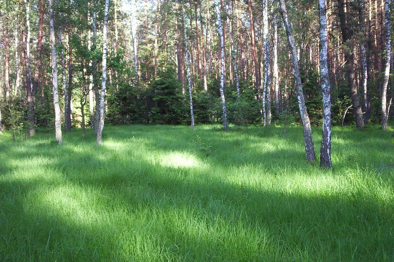
A bright, grassy meadow surrounded by a mix of tall birch and pine trees in a forest setting.
A sunlit forest clearing with lush green grass and tall birch and pine trees in Bolimowski Landscape Park.

Polany Puszczy Bolimowskiej landscape and geographic character

The landscape of Polany Puszczy Bolimowskiej is shaped by the contrast between forest and open ground. Within the wider Bolimów Forest, these protected clearings form a small archipelago of meadow land, strung together as five linked enclaves at roughly 52 degrees north latitude in central Poland.

The terrain itself is typical of central Polish lowlands, gently undulating and underlain by habitats where shallow water tables create periodic wetness. Because the forest dominates the surrounding matrix, the meadow clearings act as light wells that support humidity-loving vegetation and tall-herb communities along their edges, creating a soft transition between open meadow and woodland.

Streams and small depressions run through or border several of these enclaves, supporting the tall-herb floodplain vegetation that is one of the principal habitat types protected here.

Polany Puszczy Bolimowskiej ecosystems, habitats, and plant life

Ecologically, the site represents an unusually well-preserved example of open meadow and herbaceous habitats within a forest-dominated regional setting. The protected habitat types work together to produce a layered ecological structure: flowering meadows at the surface, tall-herb fringes along water and woodland edges, and wet depressions supporting moisture-loving plants.

The alternation of dry and moist conditions within the Molinion meadows is central to the site's ecological value, supporting a diverse flora adapted to fluctuating water levels. Combined with the extensive hay meadows, the result is a botanically rich mosaic that supports a corresponding suite of invertebrates.

Pollinators are a key ecological group here, because the butterfly species that the site is designated to protect are entirely dependent on specific meadow plants and the presence of particular ant colonies. The coexistence of these three elements: specific plants, butterflies, and ants, is what gives the site its particular conservation character.

Polany Puszczy Bolimowskiej wildlife and species highlights

Although the site is relatively small and not primarily framed as a wildlife reserve, it carries significant invertebrate and plant conservation value. The two butterfly species associated with the site, Maculinea (Phengaris) nausithous and Maculinea (Phengaris) teleius, are among the most threatened meadow butterflies in Europe and are tightly tied to wet meadow habitats and their host ant populations.

Marsh angelica, Angelica palustris, is the principal protected plant of the site, an increasingly rare wetland species that depends on the maintenance of open, periodically wet meadows. Together, these species illustrate the site's role as a refuge for meadow-dependent organisms whose traditional habitats have been lost across much of the surrounding agricultural landscape.

Larger mammals and forest birds typical of the surrounding Bolimów Forest may use the meadow clearings as foraging areas, but the defined conservation value of the site lies at the plant and invertebrate level rather than with charismatic megafauna.

Polany Puszczy Bolimowskiej conservation status and protection priorities

As a Natura 2000 site of community importance under the EU habitats directive, Polany Puszczy Bolimowskiej is legally designated for long-term protection. Its designation aims at the durable safeguarding of natural habitats and the populations of selected threatened plant and animal species.

The main conservation challenge is keeping the meadow clearings open. Without traditional mowing or grazing, these habitats would gradually succeed to shrubs and woodland, which would eliminate the open conditions required by the protected species. The site is therefore fundamentally a managed landscape conservation unit, in which low-intensity human activity is itself part of the protection regime.

By maintaining the combined presence of Molinion meadows, tall-herb fringes, and extensive hay meadows, the site preserves an ecological structure that is otherwise being lost across much of the Polish lowlands. The regulated protection of these five enclaves together, rather than as isolated fragments, helps ensure that the populations of its protected plants and butterflies remain viable.

Top sights and standout views in Polany Puszczy Bolimowskiej

The defining highlight of Polany Puszczy Bolimowskiej is its inclusion of species-rich meadow clearings within a forest-dominated region of central Poland. Across only about 134 hectares, the site combines Molinion wet meadows, tall-herb communities, and extensive hay meadows into a compact but ecologically dense network.

Its other major highlight is the concentration of rare meadow species, including the wetland-dependent starodub łąkowy (Angelica palustris) and two Maculinea butterflies. This combination of sensitive plants and invertebrate specialists within a series of small enclaves gives the site a disproportionately strong ecological profile relative to its modest area.

Best time to visit Polany Puszczy Bolimowskiej

Because the meadows are the heart of this site, late spring through summer is generally when the herbaceous vegetation and pollinators are most active. Damp meadows tend to show their richest botanical development in late spring and early summer, while hay meadows reach their flowering peak in mid-summer. Visiting during this period offers the clearest sense of why these open enclaves matter within the surrounding forest.

Outside the growing season, the meadows become quieter and visually less distinct from the surrounding woodland, though their ecological role as open habitat within the forest remains unchanged.

Monthly climate preview

Long-term representative temperature and precipitation patterns across the year

Polany Puszczy Bolimowskiej Climate Normals and Monthly Weather Records

Representative coordinates record measured monthly temperature swings from negative winter minimums to positive summer maximums alongside consistent daily precipitation. Examining the complete twelve-month climatology profile reveals deeper numerical context for temperature averages and rainfall distribution.
Annual mean8 °C
-3 °C20 °C
Jan-3°
Feb-2°
Mar
Apr
May14°
Jun18°
Jul20°
Aug20°
Sep14°
Oct
Nov
Dec-2°
Warmest month
July

20.3 °C

Coolest month
January

-3.3 °C

Wettest month
July

2.5 mm/day

Driest month
March

1.3 mm/day

Park location guide

Geography guide, regional context, and park location map for Polany Puszczy Bolimowskiej

Polany Puszczy Bolimowskiej park geography, regions, and map view in Poland

Understand where Polany Puszczy Bolimowskiej sits in Poland through a broader geographic reading of the surrounding landscape, nearby location context, and its mapped position within the national park landscape.

How Polany Puszczy Bolimowskiej fits into Poland

Poland, officially the Republic of Poland, is a Central European country spanning from the Baltic Sea in the north to the Carpathian Mountains in the south. It borders Germany, Czech Republic, Slovakia, Ukraine, Belarus, Lithuania, and Kaliningrad Oblast. The country has a temperate climate, diverse landscapes, and is known for its rich history, cultural heritage, and strong economic position within the EU.

Wider geography shaping Polany Puszczy Bolimowskiej in Poland

Poland occupies 312,696 km2 in Central Europe, extending from the Baltic Sea coast in the north to the Sudetes and Carpathian Mountains in the south. It borders Germany to the west, Czech Republic and Slovakia to the south, Ukraine and Belarus to the east, and Lithuania and Kaliningrad Oblast to the northeast. The landscape includes lowland plains, uplands, and mountain ranges.

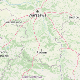
Map view of Polany Puszczy Bolimowskiej

Use this park location map to pinpoint Polany Puszczy Bolimowskiej in Poland, understand its exact geographic position, and read its mapped placement within the surrounding landscape more clearly.

Pigeon | © OpenStreetMap contributors

Location context for Polany Puszczy Bolimowskiej

Lodzkie Voivodeship
Recorded earthquake history

Review Recorded Seismic Events Near Polany Puszczy Bolimowskiej

Examine the historical record of earthquakes documented within the vicinity of Polany Puszczy Bolimowskiej. This catalogue integrates data points for each seismic event, allowing for a clearer understanding of local geophysics through MoriAtlas.

Polany Puszczy Bolimowskiej Earthquake History

Catalogued events

4 events

Strongest magnitude

Magnitude 3.7

Most recent event

Nov 6, 1988

This history includes earthquakes recorded inside the park or within 50 km of its borders

Visual exploration of forest clearings, wet meadows, and terrain character in central Poland

Polany Puszczy Bolimowskiej Photos and Protected Meadow Landscape Scenery

Photographic records capture the contrast between dense forest canopies and open meadow enclaves across the protected landscape. Visual documentation highlights the specialized wetland habitats and floodplain vegetation defining the regional ecosystem.

A bright, grassy meadow surrounded by a mix of tall birch and pine trees in a forest setting.

Park atlas

Compare nearby regional parks and connected protected landscapes across central Poland

Other Parks Near Polany Puszczy Bolimowskiej and Surrounding Protected Areas

Browse protected areas and regional reserves situated near Polany Puszczy Bolimowskiej to compare surrounding lowland ecosystems and forest habitats. Expanding the view beyond individual meadow clearings provides a deeper understanding of the broader geographical network.
Watercolor painting of a meandering river landscape with gentle hills, light green foliage in the foreground, and soft washes of color.
Protected landscapeLodz Voivodeship
Park boundaries overlap#1 closest

East

Bolimowski Park Krajobrazowy: Geography of a Central Polish Protected Landscape Area

Rawka River valley mapping and Puszcza Bolimowska forest terrain

Bolimowski Park Krajobrazowy encompasses a unique mosaic of postglacial plains and riverine ecosystems in central Poland. The area is defined by the Rawka River, which forms a network of meanders, oxbow lakes, and terraces, while surrounding forests retain historical links to the vast primeval woods of Puszcza Bolimowska. This protected territory offers a significant habitat for diverse wildlife, including moose and beaver, within a landscape characterized by its shifting transition between deep forest, wet meadows, and light oak groves.

Area
205.123 km²
Established
1986
Relief
Lowland
Climate
Temperate
Nature reserveLodzkie Voivodeship
About 25 km away#2 closest

Southwest

Doliska Nature Reserve: Protected Forest Boundaries and Geographic Landscape Context in Poland

A study in regional forest conservation and woodland ecology

Located in the Lodzkie Voivodeship, Doliska Nature Reserve is a designated phytocenotic forest area established to preserve specific woodland communities. Its primary geographic value lies in the protection of silver fir populations that exist outside their natural distribution range, making this a foundational site for regional conservation history and ecological study in the heart of lowland Poland.

Area
0.033 km²
Established
1954
Relief
Upland
Scope
Terrestrial
Nature reserveMasovian Voivodeship
About 27 km away#3 closest

East

Dąbrowa Radziejowska Nature Reserve: Protected Forest Geography in Masovian Voivodeship

An atlas entry for unique light oakwood forest landscapes and protected terrain.

Located in the Masovian Voivodeship, Dąbrowa Radziejowska Nature Reserve is a managed forest entity centered on the preservation of light-demanding oakwood habitats. This reserve provides important ecological insight into the forest composition and botanical diversity typical of the lowland plains in central Poland, offering a clear view of how small protected zones influence regional geography.

Area
0.517 km²
Established
1984
Relief
Lowland
Scope
Terrestrial
National parkMasovian Voivodeship
28 km away#4 closest

Northeast

Kampinos National Park: Geographic Profile and Protected Forest Landscape Map

Inland dune formations and wetland habitats in Masovian Voivodeship

The expansive woodland of Kampinos National Park represents a critical protected area in Poland, characterized by its parabolic sand dunes and low-lying marshes. Gain insights into the geomorphological features of this UNESCO biosphere reserve and trace the complex hydrological network that defines its unique forest environment.

Area
385.44 km²
Established
1959
IUCN
II
Relief
Lowland
A soft watercolor illustration of a marshy landscape with low rolling hills, scattered trees, and a winding stream, rendered in light green and yellow tones on a white background.
National parkMasovian Voivodeship
28 km away#5 closest

Northeast

Kampinoski Park Narodowy: Mapping the Inland Dune and Wetland Landscapes of Central Poland

A vital protected area in Masovian Voivodeship

The landscape of Kampinoski Park Narodowy is defined by the Grochalskie Piachy dune complex and diverse riparian habitats. This atlas entry covers the geological history and protected boundaries of this significant lowland forest, tracing the Vistula river valley's influence on the surrounding terrain and ecological character.

Area
385.443 km²
Established
1959
Visitors
1M annual
Relief
Lowland
A horizontal watercolor painting showing a soft, stylized landscape of rolling hills, grassy meadows, and clusters of trees under a bright, open sky.
Protected landscapeŁódź Voivodeship
About 39 km away#6 closest

Southwest

Park Krajobrazowy Wzniesień Łódzkich: Geographic Overview of Central Poland's Uplands

Mapped protected landscape featuring glacial relief and forest ecosystems

Gain insights into the physical character of Park Krajobrazowy Wzniesień Łódzkich, an area defined by its striking northern edge and deep river valleys. This protected landscape preserves significant glacial erratics, a central watershed, and diverse forest cover that contrasts with the surrounding Polish plains.

Area
115.8 km²
Established
1996
Relief
Upland
Climate
Temperate
Nature reserveMasovian Voivodeship
About 42 km away#7 closest

East

Młochowski Łęg Nature Reserve: Mapping Floodplain Forests in Masovian Voivodeship

A protected wetland woodland sanctuary along the Utrata River.

Located within the flat terrain of the Łowicz-Błonie Plain, this nature reserve conserves a representative ash-alder floodplain forest. The site serves as a vital wetland woodland refugium, featuring a complex mosaic of riparian vegetation that highlights the regional ecological character of central Poland's river valleys.

Area
0.12 km²
Established
1984
Relief
Lowland
Climate
Temperate
Nature reserveMasovian Voivodeship
About 42 km away#8 closest

East

Rezerwat przyrody Młochowski Grąd: Protected Forest Geography and Nature Reserve Map

Mapping lowland woodland communities in Masovian Voivodeship

Rezerwat przyrody Młochowski Grąd preserves a representative fragment of natural oak and pine forest within the flat plains of central Poland. Discover the ecological layout of this protected area, including its grąd deciduous communities and its role as a reference site for forest research in the Masovian Voivodeship landscape.

Area
0.27 km²
Established
1983
Relief
Lowland
Climate
Temperate

Common questions about visiting, size, designation, and location context for Polany Puszczy Bolimowskiej

Polany Puszczy Bolimowskiej FAQs for park facts, access, geography, and protected area context

Find quick answers about Polany Puszczy Bolimowskiej, including protected-area facts, park geography, trail and visitor context, and how the park fits into its surrounding country and regional landscape.
MoriAtlas Explorer

Continue Your Protected Areas Search Across the Global Atlas

Deepen your exploration by continuing the structured search for national parks and protected areas worldwide. Utilize the comprehensive filtering capabilities to compare different conservation landscapes and refine your understanding of global park geography. Discover more about the distribution and characteristics of protected natural areas.

Global natural geography