

Mori Atlas logo
Protected areaPopo Agie Wilderness

A vast protected wilderness area defined by high-elevation glacial cirques, mountain lakes, and granite peaks.

Popo Agie Wilderness: Mapping the Rugged Alpine Landscapes of the Southern Wind River Range

Popo Agie Wilderness preserves over 100,000 acres of high-alpine terrain along the continental divide in west-central Wyoming. This significant protected area within the Shoshone National Forest spans elevations exceeding 13,000 feet, showcasing a network of more than 300 glacial lakes and the iconic granite spires of the Cirque of the Towers. As part of the Greater Yellowstone Ecosystem, the wilderness provides a deep look at the rugged geological history and subalpine ecology of the Rocky Mountains.

alpine wildernessWind River Rangeglacial cirquesrock climbingalpine lakessubalpine forest

Popo Agie Wilderness

Protected area

Park overview

Structured park overview, official facts, and landscape profile for Popo Agie Wilderness

Popo Agie Wilderness park facts, protected area profile, and essential visitor context

Review the core facts for Popo Agie Wilderness, including designation, size, terrain, visitor scale, habitats, and operating context in one park-focused overview.

About Popo Agie Wilderness

Popo Agie Wilderness is a remote and largely undeveloped expanse of high country in west-central Wyoming, situated within Shoshone National Forest and forming a major portion of the southern Wind River Range. The wilderness occupies the eastern flank of the continental divide, with terrain that climbs from forested river valleys upward through twisting alpine basins, glaciated cirques, and serrated ridgelines studded with granite pinnacles.

The defining geographic feature of the wilderness is the Cirque of the Towers, a vast glacial amphitheater whose sheer walls and granite spires have earned international recognition among mountaineers. Towering above the floor of the cirque, peaks like Pingora frame the deep blue waters of Lonesome Lake, a scene that has come to symbolize the backcountry character of the Wind River Range. Twenty mountains within or near the wilderness top 12,000 feet, and the highest summit, Wind River Peak, rises to 13,192 feet, anchoring the alpine heart of the area.

Popo Agie is also a landscape of water. More than 300 lakes dot the wilderness, along with numerous tributaries that feed the Wind River. These waters shape the wilderness's natural rhythms, sustaining wetlands, wildflower meadows, and cold-water habitats that support some of the rarest native trout populations in the contiguous United States. The area's position within the Greater Yellowstone Ecosystem links Popo Agie to one of the most ecologically significant regions in North America, where habitats span from sagebrush lowlands to high-alpine tundra.

Under U.S. wilderness protections, the area is closed to motorized and mechanized travel, including bicycles, and is free from roads, logging, mining, and permanent structures. Visitors experience the wilderness on foot or on horseback, traveling through lodgepole pine and Douglas fir forests that give way to Engelmann spruce and subalpine fir as the elevation climbs toward the tree line. The result is an intact, motor-free mountain environment that preserves a deep sense of solitude and natural continuity across the southern Wind River Range.

Quick facts and research context for Popo Agie Wilderness

Popo Agie Wilderness lies within Shoshone National Forest in Fremont and Sublette counties, Wyoming, on the east side of the continental divide in the southern Wind River Range. It is classified as an IUCN Category Ib protected area, the category used for wilderness areas under U.S. federal designation, and is administered by the U.S. Forest Service.

The wilderness was originally set aside as a primitive area in 1932 and received its current wilderness designation in 1984 through the Wyoming Wilderness Act, securing a more permanent form of protection under the 1964 Wilderness Act framework. Covering more than 100,000 acres across a roughly 25-mile stretch of the southern Wind River Range, the area is part of the larger Greater Yellowstone Ecosystem.

Protection and recognition

Documented terrestrial protection scope, management framework, and conservation designations

Popo Agie Wilderness Protection Status and International Recognition Data

Popo Agie Wilderness maintains a documented terrestrial protection scope without transboundary overlap or external international recognition sources. Reviewing these verified administrative metrics provides clear insight into the official conservation framework governing the terrain.

Protection details

Protection scope
Terrestrial
Transboundary protection
No
Park context

Deeper park guide and search-rich context for Popo Agie Wilderness

Popo Agie Wilderness history, landscape, wildlife, and travel context

Explore Popo Agie Wilderness through its history, landscape character, ecosystems, wildlife, conservation priorities, cultural context, and seasonal travel timing in a structured park guide built for atlas discovery and search intent.

Why Popo Agie Wilderness stands out

Popo Agie Wilderness is best known for the Cirque of the Towers, a sweeping glacial cirque of towering granite walls, spires, and vertical cliffs that serves as one of the premier alpine climbing destinations in the Rocky Mountains. The area around Lonesome Lake, set deep within this cirque, has become an iconic backcountry landmark for climbers, hikers, and wilderness travelers. Equally central to the wilderness's identity is its high-alpine setting in the southern Wind River Range, where more than twenty peaks rise above 12,000 feet and Wind River Peak reaches above 13,000 feet. The combination of rugged stone architecture, hundreds of glacial lakes, motor-free valleys, and sweeping views of the continental divide gives the wilderness a distinctive identity within the broader Greater Yellowstone landscape.
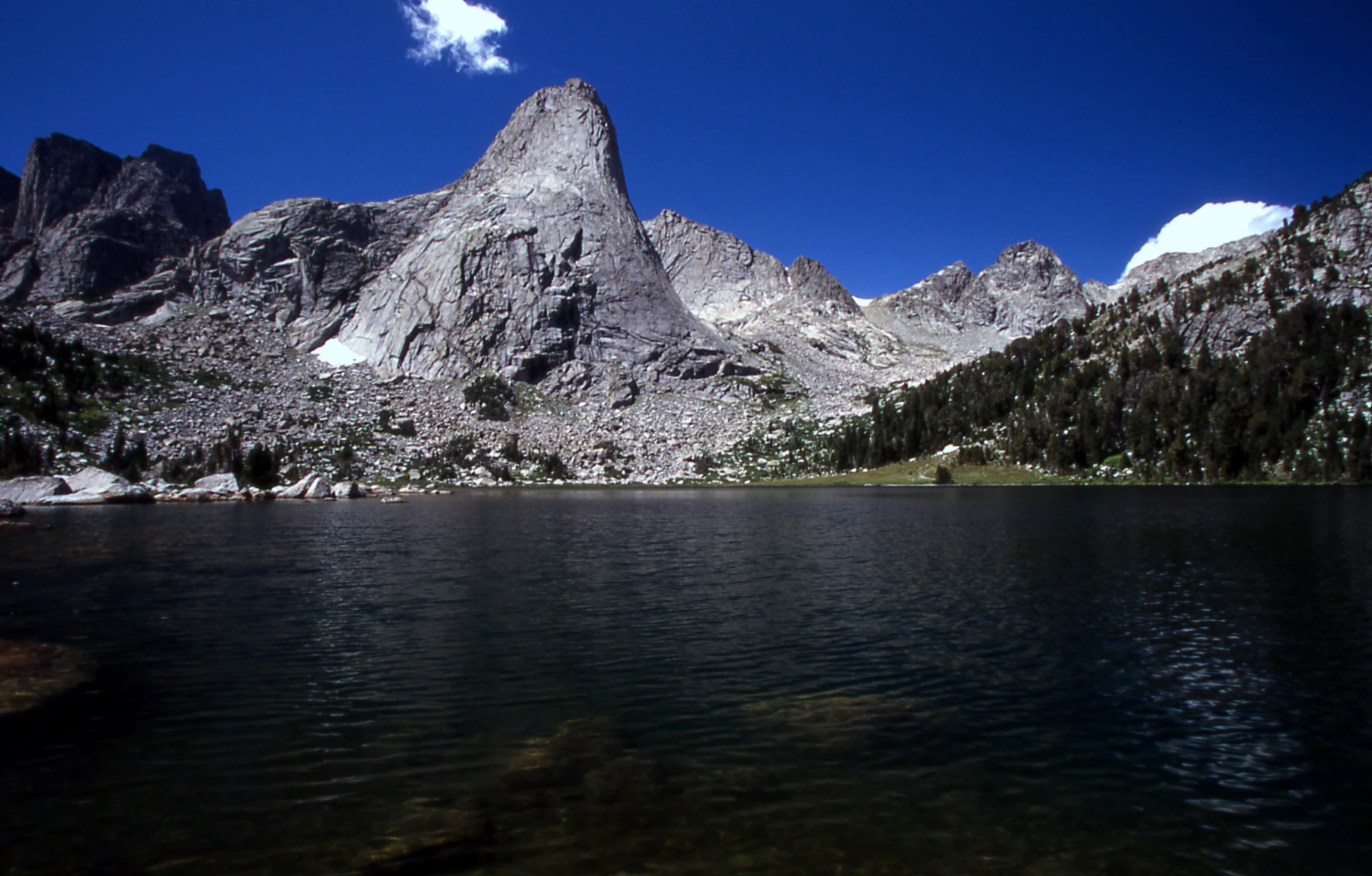
Pingora Peak and Lonesome Lake
Pingora Peak and Lonesome Lake located in the Cirque of the Towers within Shoshone National Forest and Popo Agie Wilderness

Popo Agie Wilderness history and protected-area timeline

The lands that now make up Popo Agie Wilderness were first formally recognized for their wild character in 1932, when a substantial portion of the southern Wind River Range was set aside as a primitive area under the early U.S. Forest Service framework for preserving undeveloped federal lands. The primitive area designation marked the federal government's intent to protect the area's roadless alpine terrain from logging, mining, and other forms of industrial development.

For more than five decades the primitive area remained in place, even as national wilderness policy evolved. The deeper transformation came with the 1964 Wilderness Act, which established the modern U.S. wilderness system and introduced stronger, more permanent protections for qualifying federal lands. However, it was not until 1984 that the Wyoming Wilderness Act was passed, formally elevating the Popo Agie primitive area to full wilderness status and placing it under the stricter protections of the Wilderness Act framework.

Since 1984, Popo Agie has been managed as a designated wilderness within Shoshone National Forest, administered by the U.S. Forest Service. Its management reflects the broader principles of U.S. wilderness policy: no roads, no permanent structures, no motorized or mechanized vehicles, and no logging or mining. The transition from primitive area to wilderness in 1984 marked the legal crystallization of protections that had been informally recognized for half a century, and it firmly tied the area's future to its wild, undeveloped character.

Popo Agie Wilderness landscape and geographic character

The landscape of Popo Agie Wilderness is shaped by the southern Wind River Range, where the continental divide marks the eastern boundary and the terrain rises sharply from forested valleys to some of the most dramatic alpine scenery in the American Rockies. Elevations span from roughly 8,400 feet at the lowest points to over 13,000 feet at the highest peaks, producing a vertical world where low-country forests, montane slopes, and high-alpine ridges coexist within a relatively compact geographic footprint.

Glaciation has left an especially strong imprint on the topography. The Cirque of the Towers is the most celebrated expression of this glacial legacy, a sweeping bowl carved into the range whose walls are studded with granite spires and vertical faces. Beyond the Cirque, the wilderness contains a series of glacial cirques, U-shaped valleys, moraines, and talus fields, evidence of the powerful erosional history that shaped the Wind River Range. Rock outcrops throughout the area are dominated by granitic formations, giving the high country its distinctive light-colored, rugged appearance.

Water is a constant presence on the Popo Agie landscape. More than 300 lakes lie scattered across the wilderness, ranging from small tarns tucked into glacial basins to large, clear alpine lakes such as Lonesome Lake, set deep within the Cirque of the Towers. Numerous tributaries of the Wind River originate within the area, and their courses have cut broad valleys and packed the lower elevations with riparian habitats. Together, these lakes, streams, and snowfields compose one of the densest alpine hydrological networks in the Greater Yellowstone region.

Popo Agie Wilderness ecosystems, habitats, and plant life

The ecology of Popo Agie Wilderness reflects the gradient between the dry, forested lowlands of the Wind River basin and the cold, wind-swept alpine zones near the continental divide. Forest cover is dominated by lodgepole pine and Douglas fir on middle-elevation slopes, with Engelmann spruce and subalpine fir taking over at higher elevations as conditions become harsher and the tree line thins. Above the tree line, vegetation transitions into alpine tundra, where hardy grasses, sedges, and wildflowers cling to thin soils among the rocks.

Wetlands and riparian zones associated with the network of streams and lakes add another layer of ecological complexity. Moist meadows, willow thickets, and sedge-filled margins support a dense community of plants and animals, while cold-water habitats running off snowfields and glaciers maintain stable temperatures that are critical for sensitive native aquatic species. Because the area sits within the Greater Yellowstone Ecosystem, its ecological processes are linked to one of the most intact temperate ecosystems in the lower 48 states, and changes in predator populations, fire regimes, or climate patterns in the broader ecosystem can echo through Popo Agie's habitats.

In keeping with its wilderness classification, the area is managed to preserve natural ecological processes rather than to actively shape them. Fire plays a role as a natural disturbance agent, and the wilderness's strict prohibition on logging, road-building, and motorized access helps maintain the ecological continuity that has defined the Wind River Range for centuries.

Popo Agie Wilderness wildlife and species highlights

Wildlife in Popo Agie Wilderness reflects the broader richness of the Greater Yellowstone Ecosystem, with species ranging across elevation zones and habitat types. Black bears are the most commonly observed large carnivores, while grizzly bears and wolves are present but more rarely encountered. Grizzly sightings are infrequent, and wolves, although documented in the wilderness, reflect the slow recolonization that began with recovery efforts in and around Yellowstone National Park to the north.

Moose, elk, and pronghorn are among the more visible megafauna, feeding in willowy riparian areas, montane meadows, and the high basins where forage is plentiful. These ungulate populations support the area's predator community and contribute to the wilderness's ecological character. Smaller mammals, including marmots, pikas, and a variety of squirrels, inhabit the rocky slopes and meadows and are often glimpsed by hikers and climbers moving through the higher terrain.

Birdlife is equally diverse. Trumpeter swans, bald eagles, hawks, and falcons are reported throughout the wilderness, particularly near the many lakes and tributary streams that thread through the valleys. These water-based habitats offer nesting, feeding, and stopover habitat for both resident and migratory species. Beneath the surface, the wilderness's cold, clean waters support a particularly notable native fish fauna: eight species and subspecies of trout, including forms found only in the Yellowstone region, persist in the lakes and streams, representing one of the most intact native trout complexes in the continental United States.

Popo Agie Wilderness conservation status and protection priorities

Conserved under the protections of the 1964 Wilderness Act and formally designated through the 1984 Wyoming Wilderness Act, Popo Agie Wilderness represents one of the more durable conservation commitments in the southern Wind River Range. Its wilderness status prohibits motorized and mechanized vehicle use, including bicycles, and bars logging, mining, road construction, and permanent structures within its boundaries. Camping and fishing are permitted with appropriate permits, and hunting in season is allowed in keeping with broader U.S. Forest Service wilderness policy.

Beyond its internal legal protections, the wilderness gains additional conservation significance from its location within the Greater Yellowstone Ecosystem, a connected landscape of national forests, wilderness areas, and national parklands that together support one of the largest intact temperate ecosystems in the contiguous United States. This broader ecosystem context means that Popo Agie's habitats, wildlife corridors, and watershed functions are linked to conservation outcomes far beyond its own boundaries.

The area's ecological value is heightened by the presence of rare native trout species and by the recolonization patterns of large carnivores like wolves and grizzly bears, whose recovery in the Yellowstone region has gradually extended into surrounding wilderness areas. Overuse in fragile zones, particularly around Lonesome Lake, has led to camping restrictions, illustrating the active management needed to balance recreation and preservation in a high-demand destination. These measures reflect a conservation ethos that prioritizes both ecological integrity and the long-term protection of the wilderness experience.

Popo Agie Wilderness cultural meaning and human context

Popo Agie Wilderness sits adjacent to the Wind River Indian Reservation, home to the Eastern Shoshone and Northern Arapaho tribes, whose historical and ongoing connections to the surrounding mountains and river valleys are central to the region's cultural landscape. Access into the wilderness from the north via the reservation requires obtaining a permit, a practical acknowledgment of tribal jurisdiction over lands adjoining the wilderness.

The name "Popo Agie" itself reflects this deeper heritage, deriving from the name the Shoshone people use for the river that originates within what is now the wilderness. The mountains, rivers, and lakes of the southern Wind River Range have long held meaning for Indigenous peoples of the region, both as sources of sustenance and as integral elements of identity and place. Recognizing this context is part of understanding the broader human story of the Wind River area, even as the wilderness itself is managed for its undeveloped, motor-free character.

Top sights and standout views in Popo Agie Wilderness

The standout features of Popo Agie Wilderness center on the Cirque of the Towers, whose granite spires and vertical walls have made it one of the most recognizable alpine climbing settings in the Rocky Mountains, with Pingora Peak rising dramatically above the deep waters of Lonesome Lake.

Equally defining are the wilderness's sheer scale and elevation. Twenty peaks exceed 12,000 feet, Wind River Peak reaches just above 13,000 feet, and more than 300 glacial lakes punctuate a 25-mile stretch of the southern Wind River Range. Within the Greater Yellowstone Ecosystem, the area anchors a connected network of protected wildlands, supporting rare native trout, recovering large carnivores, and dense stands of lodgepole pine, Douglas fir, Engelmann spruce, and subalpine fir from the valley floors to the tree line.

Best time to visit Popo Agie Wilderness

The character of a visit to Popo Agie Wilderness shifts sharply with the seasons, and mid to late summer is typically when most of the high country becomes accessible. By July and August, snow has generally melted from the major trails and passes, alpine wildflowers are in bloom across the meadows, and the lakes at the heart of the Cirque of the Towers are fully thawed and surrounded by active wildlife.

Late spring and early summer can bring lingering snow in the higher basins, particularly around the Cirque, while autumn cools quickly at elevation and can bring early snow to the highest peaks. Winter conditions are harsh, with deep snow and limited trail access making the upper wilderness largely the domain of experienced winter travelers. For most visitors, the summer window offers the broadest access to the wilderness's alpine terrain, lakes, and climbing routes.
Monthly climate preview

Long term temperature and precipitation patterns across twelve recorded months

Popo Agie Wilderness Climate Normals and Monthly Weather Records

Representative coordinates record annual temperature extremes spanning sub zero winter minimums to warm summer maximums alongside measured monthly precipitation rates. Detailed multi year records provide a complete month by month breakdown of historical climate normals for rigorous geographic analysis.
Annual mean1 °C
-10 °C16 °C
Jan-10°
Feb-9°
Mar-5°
Apr-1°
May
Jun11°
Jul16°
Aug15°
Sep
Oct
Nov-5°
Dec-10°
Warmest month
July

15.9 °C

Coolest month
December

-10.1 °C

Wettest month
May

2.3 mm/day

Driest month
July

0.9 mm/day

Park location guide

Geography guide, regional context, and park location map for Popo Agie Wilderness

Popo Agie Wilderness park geography, regions, and map view in United States of America

Understand where Popo Agie Wilderness sits in United States of America through a broader geographic reading of the surrounding landscape, nearby location context, and its mapped position within the national park landscape.

How Popo Agie Wilderness fits into United States of America

The United States of America is a federal presidential republic and one of the world's largest countries by area and population. It consists of 50 states across a vast territory spanning multiple time zones, with its capital in Washington, D.C. and largest city in New York City. The nation has a diverse economy, influential political system, and significant cultural and military presence globally.

Wider geography shaping Popo Agie Wilderness in United States of America

The United States occupies a vast territory in North America, bordered by Canada to the north and Mexico to the south. The 48 contiguous states stretch from the Atlantic to the Pacific Ocean, while Alaska occupies the northwestern region and Hawaii is an archipelago in the Pacific. The country encompasses diverse terrain including the Rocky Mountains, Appalachian Mountains, Great Plains, and extensive river systems.

Map view of Popo Agie Wilderness

Use this park location map to pinpoint Popo Agie Wilderness in United States of America, understand its exact geographic position, and read its mapped placement within the surrounding landscape more clearly.

Pigeon | © OpenStreetMap contributors

Location context for Popo Agie Wilderness

Wyoming
Natural feature types

Browse the Diverse Natural Landscapes and Features of the Popo Agie Wilderness

Continue geographic discovery by exploring the named landforms and alpine features throughout the Popo Agie Wilderness. This MoriAtlas collection connects the rugged granite architecture, glacial basins, and hydrological networks that shape this remote backcountry area of the southern Wind River Range.
Recorded earthquake history

Review Recorded Earthquake History Associated with Popo Agie Wilderness

MoriAtlas maintains a catalogue of recorded seismic events that have occurred in the vicinity of this alpine region. Use these records to explore the historical earthquake data and epicentre proximity for the Popo Agie Wilderness area.

Popo Agie Wilderness Earthquake History

Catalogued events

13 events

Strongest magnitude

Magnitude 5

Most recent event

Dec 13, 2025

This history includes earthquakes recorded inside the park or within 50 km of its borders

Visualizing granite spires, alpine lakes, and protected high country in Wyoming

Popo Agie Wilderness Photos and Scenic Landscapes

Examine high-resolution photography documenting the rugged terrain, glacial cirques, and dense subalpine forests of Popo Agie Wilderness. Visual references illustrate the unique topography and protected habitat characteristics defining the southern Wind River Range.

Pingora Peak and Lonesome Lake

Popo Agie Wilderness in the Wind River Range

Park atlas

Compare adjacent alpine terrain and connected regional protected areas in the Wind River Range.

Exploring Parks Near Popo Agie Wilderness and Surrounding Protected Lands

Visitors exploring Popo Agie Wilderness can browse nearby national parks and connected protected landscapes to compare regional subalpine ecosystems. Extending the geographic review reveals broader conservation terrain and adjacent wilderness areas across the surrounding mountain geography.
Protected landscapeWyoming
Park boundaries overlap#1 closest

North

Shoshone National Forest: A Comprehensive Map and Geography of America's Oldest National Forest

Rugged wilderness and glacial peaks in Wyoming

Discover the immense geographic scale of Shoshone National Forest, which protects a diverse landscape ranging from sagebrush valleys to 13,000-foot granite summits. This atlas overview details its role within the Greater Yellowstone Ecosystem and its expansive, federally designated wilderness areas, offering a clear perspective on its volcanic and glacial terrain.

Area
9,992.69 km²
Established
1891
IUCN
VI
Visitors
500K annual
Protected landscapeWyoming
16 km away#2 closest

Northwest

Fitzpatrick Wilderness: Exploring the Rugged Protected Landscapes of Western Wyoming

A core alpine environment within the Wind River Range.

Fitzpatrick Wilderness represents one of the most uncompromisingly wild segments of the Wind River Range, featuring persistent glaciers, dramatic U-shaped valleys, and high granite spires. This protected landscape offers a deep look into the alpine geography of Wyoming, preserved under the Wilderness Act to maintain its rugged character, remote glacial cirques, and intricate mountain ecosystems.

Area
803.4 km²
Established
1976
IUCN
Ib
Relief
Mountain
Protected areaWyoming
129 km away#3 closest

South

Flaming Gorge National Recreation Area: Protected Reservoir and Canyon Landscape Atlas

High desert geography and canyon terrain on the Wyoming and Utah border.

Flaming Gorge National Recreation Area features a complex geography where the Green River carves through vivid red sandstone cliffs. This protected area integrates large-scale reservoir management with mountain forest slopes and diverse river corridors, creating a unique mapped landscape that reflects the geologic character of the intermountain West.

Area
839.17 km²
Established
1968
Relief
Upland
Climate
Arid
National parkUnited States of America
133 km away#4 closest

Northwest

Grand Teton National Park: Protected Landscape and Geographic Atlas Exploration

Explore the mapped terrain and regional park geography.

Grand Teton National Park is a protected landscape offering rich geographic discovery opportunities within the United States of America. This detailed entry facilitates an atlas-style exploration of its mapped boundaries, the surrounding regional geography, and its identity as a significant national park. Understand the specific landscape context and discover its placement within the broader natural terrain of North America.

Area
1,300 km²
Established
1929
IUCN
II
Visitors
2.8M annual
Wildlife reserveWyoming
150 km away#5 closest

Northwest

Jedediah Smith Wilderness: Protected Alpine Terrain and Teton Range Geography

Glacially sculpted high-country basins in western Wyoming

Spanning the western face of the Teton Range, the Jedediah Smith Wilderness serves as a federally protected buffer for iconic mountain landscapes. The region features dramatic cirques, hanging valleys, and dense subalpine forest habitats, forming an essential, roadless link within the broader Greater Yellowstone Ecosystem. Explore the terrain features and structural geography that define this remote high-country wilderness area.

Area
499.59 km²
Established
1984
IUCN
Ib
Relief
Mountain
National parkWyoming
151 km away#6 closest

Northwest

Yellowstone National Park: US National Park Protected Landscape & Geographic Atlas

Explore mapped boundaries and regional natural landscape context.

Yellowstone National Park represents a significant protected landscape within Wyoming, designated as a US national park. This entry offers detailed insight into its geographic scope, mapped boundaries, and the unique natural terrain that defines it. Understand its role in regional geography and discover its protected-area identity through a structured atlas exploration, providing context for its conservation landscape.

Area
8,983.18 km²
Established
1872
IUCN
II
Visitors
4.7M annual
Wildlife reserveUtah
215 km away#7 closest

Southwest

Mount Naomi Wilderness: Mapping High-Altitude Protected Landscapes in Northern Utah

Alpine summits, forested ridges, and subalpine lake basins

Situated in the Bear River Range of northern Utah, Mount Naomi Wilderness stands as a protected corridor of rugged mountain terrain. This wilderness area preserves a diverse high-elevation environment, spanning from the steep western canyons of the Logan River to the prominent summits of Naomi Peak. It serves as a vital point of geographic interest for understanding the subalpine ecosystems and wilderness boundaries within the Uinta-Wasatch-Cache National Forest.

Area
180.18 km²
Established
1984
IUCN
Ib
Relief
Mountain
Protected landscapeMontana
222 km away#8 closest

North

Bighorn Canyon National Recreation Area: Maps and Protected Landscape Geography

A reservoir-anchored protected area in the Montana high desert

Defined by its striking contrast between deep blue reservoir water and sheer canyon walls, Bighorn Canyon National Recreation Area protects an essential arid landscape in the Mountain West. This region encompasses portions of the Pryor Mountains and the historic Bad Pass Trail, offering a window into the intersection of vast high-desert plains and rugged mountain terrain.

Area
486.82 km²
Established
1966
Visitors
217.7K annual
Relief
Upland

Common questions about visiting, size, designation, and location context for Popo Agie Wilderness

Popo Agie Wilderness FAQs for park facts, access, geography, and protected area context

Find quick answers about Popo Agie Wilderness, including protected-area facts, park geography, trail and visitor context, and how the park fits into its surrounding country and regional landscape.
MoriAtlas Explorer

Continue Your Protected Areas Search Across the Global Atlas

Deepen your exploration by continuing the structured search for national parks and protected areas worldwide. Utilize the comprehensive filtering capabilities to compare different conservation landscapes and refine your understanding of global park geography. Discover more about the distribution and characteristics of protected natural areas.

Global natural geography