

Mori Atlas logo
Nature reservePostřekovské rybníky

A historic network of fishponds and meadows forming a significant sanctuary for migratory bird populations.

Postřekovské rybníky: Mapping the Protected Wetland Landscapes of the Plzeňský kraj Region

Postřekovské rybníky represents a protected natural reserve within the Domažlice District of Plzeňský kraj. This area spans roughly 96.5 hectares and preserves a centuries-old rural landscape where a dense mosaic of small fishponds intersects with wet grasslands and the floodplain of the Klenečský stream. Beyond its historical land use, the reserve serves as a critical wetland habitat for diverse waterbirds and is recognized for sustaining a unique ecological balance within the Bohemian interior.

wetlandsfishpondsbirdwatchingmigratory birdspond landscapenature reserve
A digital illustration showing a tranquil landscape with a grassy foreground, a calm river or pond, a line of pine trees, and jagged mountains with a waterfall under a pastel-colored sky.

Postřekovské rybníky

Nature reserve

Park overview

Structured park overview, official facts, and landscape profile for Postřekovské rybníky

Postřekovské rybníky park facts, protected area profile, and essential visitor context

Review the core facts for Postřekovské rybníky, including designation, size, terrain, visitor scale, habitats, and operating context in one park-focused overview.

About Postřekovské rybníky

Postřekovské rybníky is one of the more quietly distinctive nature reserves in the Czech Republic, even if it is not among the largest. Located in the rolling countryside of western Bohemia, between the villages of Postřekov and Klenčí pod Čerchovem, the reserve captures a piece of an older cultural landscape that has nearly disappeared elsewhere in the country. Rather than protecting a single dramatic ecosystem, it preserves a composite scene of small fishponds, wet meadows, reed beds, and the floodplain of the Klenečský stream.

The reserve covers roughly 96.5 hectares and was formally established in 1990. Its purpose is to protect a remnant of the traditional Bohemian landscape, in which a chain of more than twenty small ponds, surrounded by damp meadows, has been managed extensively for centuries. This long continuity of light, careful use is what made the site biologically rich in the first place. When the area received formal protection, the goal was not only to conserve individual species but also to maintain the relationship between water, meadow, and traditional land management that produces such diversity.

Today the reserve is best appreciated as a wetland of national importance and as a key bird area in the region. More than 300 species of vascular plants have been documented here, and the mosaic of water bodies, wet grass, and reed vegetation supports breeding birds, migratory waterfowl and waders, and a wide range of invertebrates adapted to pond landscapes. The site also includes rare beetles and leaf beetles of conservation interest, reinforcing its reputation as a small but unusually rich wetland complex.

For visitors interested in nature observation, the reserve offers a clear sense of how historical fish farming and wildlife conservation can coexist. The ponds remain in active use, the meadows continue to be mowed in traditional patterns, and the result is a living example of how old Central European rural landscapes can still function as habitat.

Quick facts and research context for Postřekovské rybníky

Postřekovské rybníky is a Czech nature reserve (přírodní rezervace) in the Domažlice District of the Plzeň Region, established in 1990 and administered by the Agency for Nature Conservation and Landscape Protection of the Czech Republic. It lies at elevations between roughly 416 and 434 metres above sea level and covers approximately 96.5 hectares near the western Bohemian border area.

The site is a traditional fishpond landscape made up of more than twenty small, extensively managed ponds surrounded by wet meadows and bordered by the Klenečský stream. Botanists have recorded more than 300 species of vascular plants, and the reserve is classified as a wetland of supralocal importance. Its principal conservation value lies in bird populations: it is an important breeding area, a migratory stopover for waterbirds, and a refuge where traditional land use still shapes a biologically rich cultural landscape.

Protection and recognition

Terrestrial conservation scope and documented protected area framework

Postřekovské rybníky Protection Status and Designated Area Records

Postřekovské rybníky maintains a registered terrestrial protection scope within the broader protected area framework. Official records compile designated status details and management parameters for geographic analysis.

Protection details

Protection scope
Terrestrial
Transboundary protection
No
Park context

Deeper park guide and search-rich context for Postřekovské rybníky

Postřekovské rybníky history, landscape, wildlife, and travel context

Explore Postřekovské rybníky through its history, landscape character, ecosystems, wildlife, conservation priorities, cultural context, and seasonal travel timing in a structured park guide built for atlas discovery and search intent.

Why Postřekovské rybníky stands out

Postřekovské rybníky is best known for its dense network of small, extensively managed fishponds set within wet meadows, forming one of the most important bird sites in the Domažlice region. The reserve is especially recognized as a breeding area for the white-spotted bluethroat, a Central European subspecies of the bluethroat, and as a migratory stopover where curlews, marsh harriers, hen harriers, and red-crested pochards pass through. Beyond its birdlife, the area is also valued as a surviving example of the traditional Bohemian fishpond landscape, in which human management of small water bodies sustains a remarkable diversity of wetland plants and invertebrates. The combination of historical land use and ecological richness makes the reserve a benchmark site for understanding how small-scale pond systems can remain biologically valuable in a modern agricultural region.
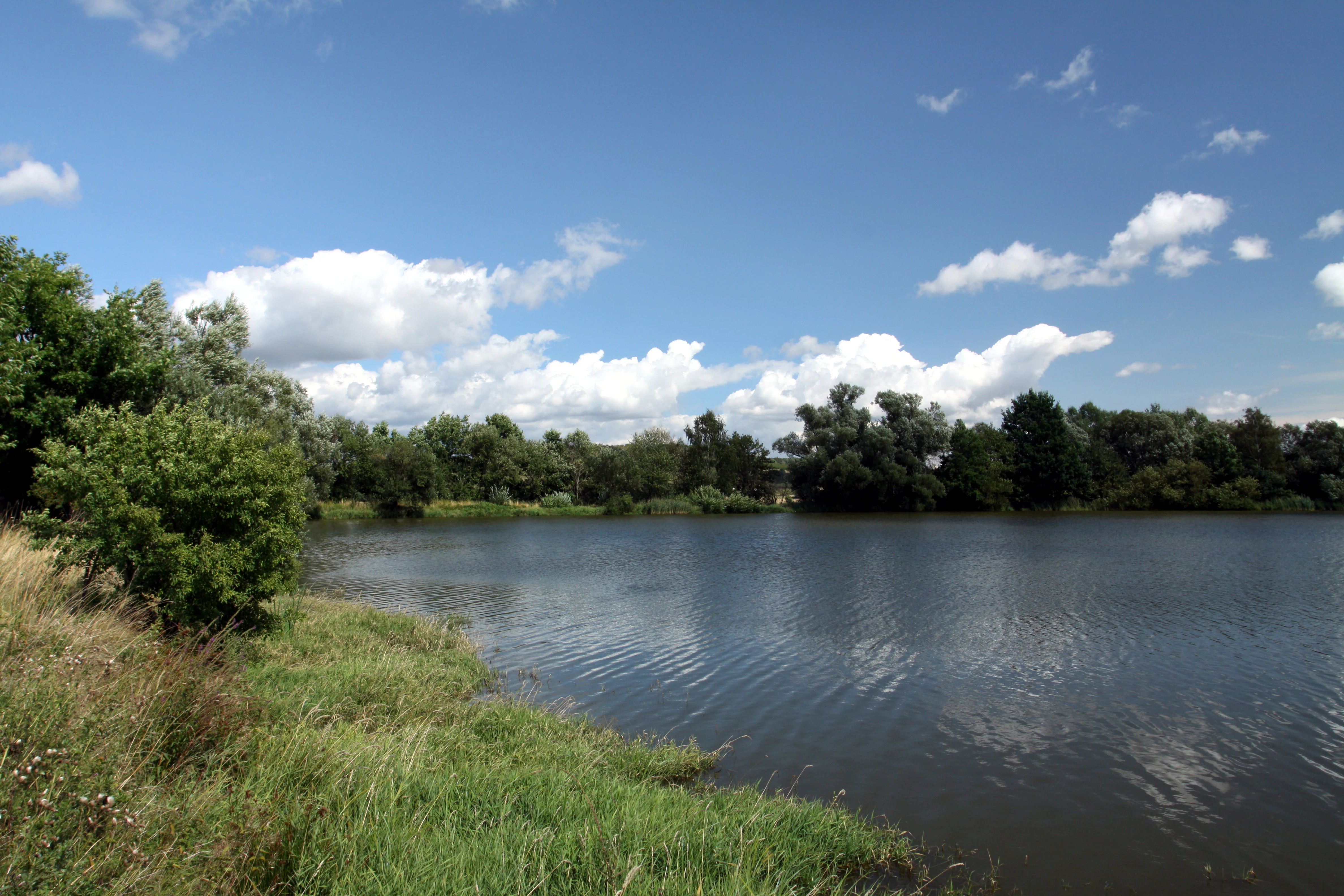
A wide view of a pond with grassy banks in the foreground and a dense line of trees across the far bank under a blue sky with scattered clouds.
A summer view of Obecni rybnik, one of the ponds located within the Postrekovske rybniky nature reserve.

Postřekovské rybníky history and protected-area timeline

The Postřekovské rybníky reserve was formally established in 1990, after a period in which many small pond systems in western Bohemia had been simplified, drained, or placed under more intensive use. The protected designation was intended to safeguard what remained of the traditional fishpond landscape between Postřekov and Klenčí pod Čerchovem, along with its associated wet meadows and biological diversity.

Although the ponds themselves are considerably older, dating back to the long history of fish farming in the Bohemian lowlands and foothills, the reserve marks a turning point in how the landscape is treated. It shifted the area from being simply a working agricultural landscape to being recognized also as a conservation site of regional and national importance. Subsequent surveys documented more than 300 vascular plant species and highlighted the reserve's exceptional value for breeding and migratory birds, reinforcing its status as a wetland of supralocal significance.

Postřekovské rybníky landscape and geographic character

The landscape of Postřekovské rybníky is shaped by a dense mosaic of small water bodies set into gentle, low-lying terrain near the foothills of the Czech, or Bohemian, Forest. The reserve rests at elevations roughly between 416 and 434 metres above sea level, an altitude that supports cool, moisture-retaining conditions ideal for wetland vegetation.

Rather than dramatic landforms, the scene here is one of subtle repetition: a chain of more than twenty small fishponds linked by the floodplain of the Klenečský stream, with damp meadows and reed fringes between them. The ponds are small and irregularly shaped, reflecting their historical origins as village-scale fish farms rather than large industrial reservoirs. Together with their surroundings, they create a textured environment of open water, marshy edges, grassy strips, and scattered wet woodland.

This fine-grained terrain is exactly what gives the reserve its character. The visible landscape is not spectacular in the alpine or mountain sense, but it is quietly intricate, with small differences in elevation and soil moisture producing a patchwork of habitats within a relatively compact area.

Postřekovské rybníky ecosystems, habitats, and plant life

Ecologically, Postřekovské rybníky is defined by its pond and meadow complex. The combination of open water, shallow pond edges, reed beds, and surrounding wet grassland produces a layered environment where aquatic, marsh, and meadow species can be found within short distances of one another. This variability is central to the reserve's biodiversity.

Botanists have recorded more than 300 species of vascular plants across the site, a high figure for an area of about 96.5 hectares and a clear indication of how rich a traditional fishpond landscape can be. The mix of permanently wet pond margins, seasonally flooded meadows, and drier grassy patches supports a wide range of wetland, meadow, and ruderal plants adapted to changing water levels and traditional mowing regimes.

The pond system also creates favorable conditions for invertebrates, including rare ground beetles such as Amara concinna and uncommon leaf beetles, which in turn support the broader food web on which the reserve's birdlife depends. The site's classification as a wetland of supralocal importance reflects this combination of botanical richness, invertebrate diversity, and stable aquatic habitats.

Postřekovské rybníky wildlife and species highlights

The birdlife of Postřekovské rybníky is its most prominent natural feature. The reserve is recognized both as a nesting ground for several important species and as a stopover during migration periods, giving it year-round ornithological value.

Among breeding species, the white-spotted bluethroat, the Central European subspecies of the bluethroat, is the reserve's signature bird and a major reason for its protected status. The marsh harrier also nests here, along with the Eurasian penduline tit, various ducks, and a range of waders that use the pond margins and wet meadows for feeding. The combination of open water, reed beds, and wet grassland provides nesting cover, foraging habitat, and feeding edges in close proximity.

During migration the reserve becomes a temporary refuge for additional species. Curlews, hen harriers, red-crested pochards, and several species of godwits and other shorebirds pause here, drawn by the same qualities that support breeding birds: a network of shallow, productive ponds set within meadows. This dual role, breeding area plus migratory stopover, gives the reserve a strong identity as a wetland of national importance for bird conservation in the western Bohemian region.

Postřekovské rybníky conservation status and protection priorities

The conservation significance of Postřekovské rybníky lies in its preservation of a small but exceptionally well-kept traditional fishpond landscape, and in the biological value that landscape continues to support. Protected formally in 1990 and administered by the Agency for Nature Conservation and Landscape Protection of the Czech Republic, the reserve safeguards roughly 96.5 hectares of ponds and wet meadows along the Klenečský stream.

The site's value extends well beyond its boundaries. It is classified as a wetland of supralocal significance, reflecting its botanical richness, its diversity of breeding and migratory birds, and its importance for rare invertebrates adapted to traditional pond systems. The protection status is intended not only to maintain current habitats but also to preserve the centuries-old pattern of extensive pond management that produced them.

In practical terms, the reserve demonstrates how continued, light-intensity human use of ponds and meadows can remain compatible with high biodiversity. Conservation here depends less on excluding human activity than on preserving the careful balance of water management, mowing, and traditional fish farming that keeps the mosaic of habitats intact.

Postřekovské rybníky cultural meaning and human context

The ponds and meadows around Postřekov sit within a region with a long tradition of small-scale fish farming and village-based land management. Local communities historically built and maintained the chain of more than twenty small ponds not only for fish production but also as part of a working rural landscape that combined water, meadow, and settlement.

This long-standing interaction between people and the land is an essential part of the reserve's identity. The wet meadows have been shaped by traditional mowing and grazing regimes, and the ponds continue to be managed in ways that sustain both their economic and ecological roles. As a result, the reserve is not a wilderness retreat but a living cultural landscape, in which ongoing human care is part of why the site is biologically valuable.

Top sights and standout views in Postřekovské rybníky

The standout qualities of Postřekovské rybníky are its dense network of small, traditionally managed fishponds, its exceptionally rich wetland flora, and its strong bird focus, particularly as a breeding area for the white-spotted bluethroat and a stopover for migratory waders and waterfowl. The reserve's value rests equally on its habitats and on the centuries-old pattern of land use that continues to shape them.

Its most distinctive trait is that all of these elements are concentrated into a compact, accessible area of roughly 96.5 hectares, where ponds, meadows, reed edges, and floodplain form a coherent and biologically rich whole. This combination of scale, biological quality, and cultural continuity makes Postřekovské rybníky a particularly representative example of the traditional Bohemian fishpond landscape.

Best time to visit Postřekovské rybníky

The reserve rewards visits across much of the year, but its character shifts noticeably with the seasons. Late spring and early summer bring active breeding birds, dense meadow vegetation, and the most complete expression of the site's overlap between wildlife and traditional land use, while autumn migration brings a wider variety of waterbirds and waders passing through or pausing on the ponds.

Wet conditions dominate the landscape in any season, so cooler or milder days often offer the best experience for walking, observation, and quiet enjoyment of the meadows and pond margins. The traditional mowing of surrounding meadows, usually carried out in summer, also affects the visual texture of the reserve, opening up views across the fields and creating fresh conditions for late-season plant and insect activity.


Monthly climate preview

Long-term temperature and precipitation patterns across representative coordinates

Postřekovské rybníky Climate Normals and Annual Weather by Month

Postřekovské rybníky records measured baseline temperatures and daily precipitation rates across twelve representative monthly intervals from NASA climatology data. Examining the complete monthly climate profile reveals specific shifts in average temperature and precipitation normals for this protected area.
Annual mean8 °C
-3 °C18 °C
Jan-3°
Feb-2°
Mar
Apr
May12°
Jun16°
Jul18°
Aug18°
Sep13°
Oct
Nov
Dec-2°
Warmest month
July

18.2 °C

Coolest month
January

-2.9 °C

Wettest month
June

2.9 mm/day

Driest month
April

1.4 mm/day

Park location guide

Geography guide, regional context, and park location map for Postřekovské rybníky

Postřekovské rybníky park geography, regions, and map view in Czechia

Understand where Postřekovské rybníky sits in Czechia through a broader geographic reading of the surrounding landscape, nearby location context, and its mapped position within the national park landscape.

How Postřekovské rybníky fits into Czechia

Czech Republic is a landlocked Central European country with a population of approximately 10.9 million people. The nation was established as an independent state on January 1, 1993, following the dissolution of Czechoslovakia. Its capital and largest city is Prague, with other major urban centers including Brno, Ostrava, Plzeň, and Liberec.

Wider geography shaping Postřekovské rybníky in Czechia

The Czech Republic is a landlocked country in Central Europe. It is bordered by Germany to the west, Austria to the south, Poland to the northeast, and Slovakia to the southeast. The landscape is predominantly hilly, with the territory covering 78,871 square kilometers.

Map view of Postřekovské rybníky

Use this park location map to pinpoint Postřekovské rybníky in Czechia, understand its exact geographic position, and read its mapped placement within the surrounding landscape more clearly.

Pigeon | © OpenStreetMap contributors

Location context for Postřekovské rybníky

Plzeňský kraj

Visualizing the traditional Bohemian fishpond landscape and wetland habitats

Postřekovské rybníky Photos and Landscape Scenery

Visual documentation captures the intricate network of small fishponds, damp meadows, and reed fringes that define the protected area. Examining these terrain photographs reveals the subtle geography and specialized wetland habitats unique to this Bohemian nature reserve.

A wide view of a pond with grassy banks in the foreground and a dense line of trees across the far bank under a blue sky with scattered clouds.

Park atlas

Discover related wetland reserves and protected landscapes across the surrounding region

Other Parks and Protected Areas Near Postřekovské rybníky for Regional Comparison

Explore nearby national parks and protected areas sharing similar wetland habitats, lowland terrain, and conservation features with Postřekovské rybníky. Comparing adjacent regional landscapes provides a broader geographic perspective on traditional Bohemian fishpond ecosystems.
Natural monumentPlzeňský kraj
About 19 km away#1 closest

Northwest

Veský mlýn Natural Monument: Geographic Overview and Protected Landscape Mapping

A preserved wetland mosaic in the Bohemian Forest region

Veský mlýn is a protected natural monument in western Bohemia characterized by its transitional mire and wet meadow habitats. Situated within the Plzeňský kraj region, the site provides a distinct look at how former restricted border zones have maintained high ecological value. Its geography includes the headwaters of the Plešský potok and rare flora that thrive in the cool, moist conditions of the local crystalline foothills.

Area
0.321 km²
Established
2002
IUCN
IV
Relief
Upland
Protected landscapeBavaria
About 20 km away#2 closest

Northwest

Naturpark Nördlicher Oberpfälzer Wald: Protected Landscape and Regional Geography Map

Forested upland terrain and volcanic geology in Bavaria

Explore the structured geography of Naturpark Nördlicher Oberpfälzer Wald, a massive protected region in Bavaria. This detailed profile highlights the park's characteristic ridge and valley terrain, volcanic basalt landmarks, and its role as a vital ecological belt along the international border.

Area
1,380 km²
Water
Minor water
A soft watercolor illustration depicting a panoramic mountain landscape with evergreen trees in the foreground and rolling hills in the background in pastel shades of green, yellow, and pink.
Protected landscapeBavaria
About 25 km away#3 closest

Southwest

Naturpark Oberer Bayerischer Wald: Protected Landscape Geography and Map

Mountain summits, river wetlands, and quartzite ridges in Bavaria

Spanning over 1,700 square kilometers, Naturpark Oberer Bayerischer Wald stands as a major protected area in Bavaria. This territory features a complex interplay of high-altitude forest, glacial lake basins, and unique geological landmarks including the 150-kilometer Pfahl ridge. Discover how these diverse landscapes, ranging from alpine terrain to river floodplains, are mapped and preserved within this significant regional protected zone.

Area
1,733 km²
Established
1989
Relief
Mountain
Climate
Temperate
Protected landscapeBavaria
About 35 km away#4 closest

West

Naturpark Oberpfälzer Wald: Geographic Atlas and Protected Landscape Overview in Bavaria

Examining the terrain, forest ridges, and regional drainage patterns.

Naturpark Oberpfälzer Wald serves as a prominent protected landscape in Bavaria, Germany. This area encompasses a complex of Scots pine and Norway spruce forests, rugged rock outcrops, and the historic Charlottenhofer Weihergebiet. The region connects seamlessly to broader European mountain belts, offering a unique opportunity to study the intersection of traditional land use and natural conservation within the Oberpfalz administrative district.

Area
823 km²
Established
1994
Relief
Mountain
Climate
Temperate
A horizontal watercolor painting depicting a soft, atmospheric landscape with a foreground of purple and pink wetland grasses, a midground of scattered green coniferous trees, and hazy, distant mountain silhouettes in the background.
Nature reservePlzeňský kraj
About 43 km away#5 closest

Southeast

Prameniště Nature Reserve: Protected Wetland and Mountain Spring Systems in Plzeňský kraj

Mapping the hydrological headwaters of the Šumava Mountains

Prameniště Nature Reserve represents a critical cluster of protected mountain springs and peat bogs across the Pancířský hřbet ridge. By focusing on the source areas for the Křemelná and Řezná rivers, this reserve maintains essential hydrological integrity within the wider Plzeňský kraj landscape. Its mosaic of sub-alpine peatlands and montane spruce forests provides an important study of high-altitude wetland geography in the central European mountains.

Area
3.536 km²
Established
1994
IUCN
IV
Relief
Mountain
Watercolor illustration of a river flowing through a forested landscape with rolling hills in the background
National parkSouth Bohemian Region
About 45 km away#6 closest

Southeast

Šumava National Park: Czech Republic's Premier Forested National Park and Protected Landscape

Explore the unique glacial lakes, peat bogs, and regional geography.

Šumava National Park, situated in the South Bohemian Region of the Czech Republic, is the nation's largest protected area and a vital component of Central Europe's forest ecosystems. This entry details its expansive terrain, highlighting the significant peat bog complexes and ancient glacial lakes that define its unique landscape. Discover the park's geographic context, mapped boundaries, and its importance as a protected natural asset within the broader regional atlas.

Area
680.64 km²
Established
1991
IUCN
II
Visitors
2M annual
Watercolor painting showing mountains, forests, and valleys in a landscape.
National parkGermany
About 46 km away#7 closest

Southeast

Bavarian Forest National Park: Protected Landscape and Regional Geography Atlas

Explore mapped terrain and protected park boundaries in Germany.

Dive into the specifics of Bavarian Forest National Park, a key protected area noted for its distinct landscape and geographic importance. This MoriAtlas entry details the park's mapped boundaries and its setting within the surrounding regional geography, offering a clear atlas-style view of its natural terrain. Understand its identity as a national park and discover its place in Germany's protected lands.

Area
242.45 km²
Established
1970
IUCN
II
Visitors
1.3M annual
Natural monumentPlzeňský kraj
About 50 km away#8 closest

East

Velký kámen Natural Monument: Protected Siliceous Outcrops and Regional Geography

Geological landscape within the Plánický hřeben area of Plzeňský kraj.

Velký kámen serves as a notable protected landmark featuring an elongated siliceous rock formation and remnants of natural beech forest. Its location on the V Kopaninách hillside makes it a key feature of the broader regional geography, while its status as both a natural monument and an Eneolithic archaeological site provides a layered perspective on the Bohemian landscape.

Area
0.012 km²
IUCN
IV
Relief
Upland
Scope
Terrestrial

Common questions about visiting, size, designation, and location context for Postřekovské rybníky

Postřekovské rybníky FAQs for park facts, access, geography, and protected area context

Find quick answers about Postřekovské rybníky, including protected-area facts, park geography, trail and visitor context, and how the park fits into its surrounding country and regional landscape.
MoriAtlas Explorer

Continue Your Protected Areas Search Across the Global Atlas

Deepen your exploration by continuing the structured search for national parks and protected areas worldwide. Utilize the comprehensive filtering capabilities to compare different conservation landscapes and refine your understanding of global park geography. Discover more about the distribution and characteristics of protected natural areas.

Global natural geography