Mori Atlas logo
National parkPredelta National Park

Discover the unique wetland ecosystems and river island geography at the start of the Paraná Delta.

Predelta National Park: National Park Atlas and Mapped Protected Landscape in Entre Ríos

(Parque Nacional Predelta)

Predelta National Park represents a crucial protected area at the geographic threshold where the Paraná River begins its expansive delta formation. This Argentinian national park in Entre Ríos Province preserves a complex mosaic of wetland environments, river islands, and interconnected waterways, offering a distinct landscape context for atlas exploration. Users can discover the park's mapped boundaries and the unique ecological transitions that define this vital South American wetland system.

WetlandsDelta EcosystemRiver IslandsBirdwatchingArgentina National ParksParaná River

Predelta National Park

National park

Park overview

Structured park overview, official facts, and landscape profile for Predelta National Park

Predelta National Park park facts, protected area profile, and essential visitor context

Review the core facts for Predelta National Park, including designation, size, terrain, visitor scale, habitats, and operating context in one park-focused overview.

About Predelta National Park

Predelta National Park represents a carefully preserved window into the ecological character of the Upper Paraná Delta, a region that has shaped both the natural history and human settlement patterns of northeastern Argentina. The park's geography is defined by the complex interplay between the Paraná River and its developing delta system, where watercourses, islands, and wetlands create a constantly shifting landscape. The protected area includes both mainland portions along the river's left bank and three significant islands that demonstrate the full range of delta environments. This diversity of habitats, from forested levees to open lagoons to seasonally inundated marshes, supports an extraordinary concentration of biodiversity despite the park's relatively modest size. The park's management plan, approved in 2019, guides conservation and visitor use activities, with the recreational zone concentrated at Paraje La Jaula, the only point of terrestrial access, located five kilometers from Diamante. Visitors can explore interpretive trails, enjoy shore-based sport fishing, camp, and observe the rich avian fauna that characterizes the region.

Quick facts and research context for Predelta National Park

Predelta National Park occupies 2,604 hectares in the Diamante Department of Entre Ríos Province, Argentina, at coordinates approximately 32°9′S 60°38′W. The park was formally established on January 13, 1992, though the legislation was passed on December 19, 1991, and it is administered by the Administración de Parques Nacionales. The protected area encompasses a stretch of the Paraná River along its left bank, along with three main islands: del Ceibo, las Mangas, and del Barro. The region experiences a humid subtropical to tropical climate moderated by the river's influence, with an average annual temperature of 19°C. The park serves as the northernmost gateway to the Paraná Delta system, which covers approximately 1.2 million hectares and represents one of the world's largest river deltas.

Protection and recognition

Documenting terrestrial management scope and official conservation frameworks for the river delta landscape.

Predelta National Park Protection Status and Protected Area Designation Details

Browse verified geographic data regarding the terrestrial protection status and documented conservation boundaries of Predelta National Park. Analyzing official designations and legal frameworks helps researchers understand the management context of the regional riverine landscape.

Protection details

Protection scope
Terrestrial
Transboundary protection
No
Park context

Deeper park guide and search-rich context for Predelta National Park

Predelta National Park history, landscape, wildlife, and travel context

Explore Predelta National Park through its history, landscape character, ecosystems, wildlife, conservation priorities, cultural context, and seasonal travel timing in a structured park guide built for atlas discovery and search intent.

Why Predelta National Park stands out

Predelta National Park is best known for its position as the threshold between the continental Paraná River and the extensive delta archipelago, a transition zone where aquatic and terrestrial ecosystems intermingle in a dynamic landscape. The park protects three distinct habitat types: the albardón (natural levees) supporting gallery forests, the open-water lagoons with their floating vegetation, and the low-lying bañados (seasonally flooded wetlands). The park has become particularly recognized for its remarkable birdlife, especially the matraca or ringed kingfisher, which has been adopted as the park's emblematic species due to its abundance and visibility along waterways. The park also preserves one of the few remaining populations of the yacaré ñato (broad-snouted caiman), a species once thought to be extinct in the region. Additionally, Predelta provides crucial habitat for capybaras, South America's largest rodent, whose tracks can be observed along the park's interpretive trails.
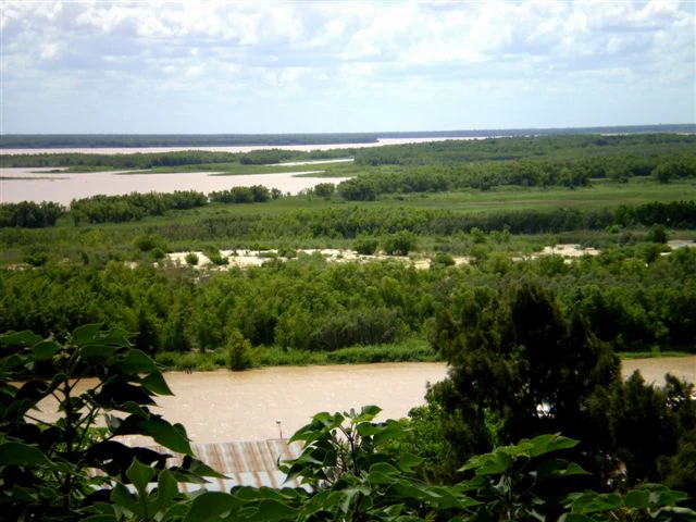
Wide landscape of the Paraná River with muddy waters, dense green forests, and distant horizon under a partly cloudy sky
Wide view of the Paraná River delta within Predelta National Park, Argentina

Predelta National Park history and protected-area timeline

The establishment of Predelta National Park followed a decade-long process of advocacy, legislation, and intergovernmental coordination. In October 1986, National Deputy Rodolfo Miguel Parente from Entre Ríos proposed a declaration requesting the executive branch to study the creation of a national park in the Diamante area. The municipal council of Diamante responded in May 1987 by passing Ordinance 14/1987, which donated 2,458 hectares of islands and wetlands to the national government for the creation of a protected area. This gesture was followed by a collaboration agreement between the municipality and the Administración de Parques Nacionales in September 1987. Provincial Law 8491, passed in July 1991, transferred jurisdiction over the donated land to the national state. On December 19, 1991, National Law 24.063 was enacted, formally creating Predelta National Park, with the law taking effect on January 13, 1992. The formal inauguration and possession by the national parks administration occurred on May 19, 1992. In 1997, the park received its own administrator, becoming independent from El Palmar National Park. The park expanded in 2022 when National Law 27672 incorporated the adjacent Campo Nacional Coronel Sarmiento, a 146-hectare property previously owned by the Argentine Army.

Predelta National Park landscape and geographic character

The landscape of Predelta National Park is defined by the dynamic processes of delta formation, where the Paraná River's waters begin to braid into multiple channels and create islands through sediment deposition. The park encompasses three primary landscape zones: the albardón or natural levee system, which represents the highest ground and supports gallery forests; the lagoon areas with their open water surfaces and floating aquatic vegetation; and the bañados, the low-lying seasonally flooded wetlands. The park is delimited entirely by watercourses, including the main channel of the Paraná River to the west, and smaller waterways such as arroyo La Azotea, riacho Vapor Viejo, arroyo Las Mangas, and arroyo Saca Calzones that form its other boundaries. The three islands within the park, del Ceibo, las Mangas, and del Barro, each represent different stages of delta development and support distinct vegetation communities. The landscape also includes features such as madrejones (oxbow lakes), sandy beaches colonized by willow and alder thickets, and dense stands of paja de techar grass in lower areas.

Predelta National Park ecosystems, habitats, and plant life

The ecological character of Predelta National Park reflects its position within the Paraná Delta and Islands Ecoregion, a region of global significance for wetland biodiversity. The ecoregion encompasses a vast system of low, flooded islands within the middle Paraná and Paraguay river valleys. Within this larger context, Predelta occupies a transitional zone where the river's floodplain transitions into true delta conditions. The park's forests are dominated by ceibo and curupí trees on the levees, while lower areas support white timbó forests. The understory and open areas feature extensive pajonal grasslands dominated by paja de techar and paja boba grasses. The lagoon systems support floating aquatic vegetation including the distinctive irupé (Victoria cruziana), a giant water lily with circular leaves that can reach over a meter in diameter. This plant community creates one of the most visually striking elements of the park's natural landscape, providing shelter for fish and invertebrates while supporting a complex food web.

Predelta National Park wildlife and species highlights

The wildlife of Predelta National Park is exceptionally diverse, particularly in avifauna, which has made birdwatching one of the park's signature activities. The matraca or ringed kingfisher has become the park's emblematic species, being the largest kingfisher in the region with distinctive plumage and frequently observed hunting along waterways. The park supports over 120 documented bird species, including ducks, guaras (limpkin), chajás (southern screamer), storks, herons, and numerous other water-associated species. The spinous red spider monkey, though not present here, builds distinctive nests from sticks that hang over water. The park's mammalian fauna includes the capybara, the world's largest rodent, which is commonly observed along trails and waterways, as well as coypus (coipo), otters, and the river otter. Reptile species include the broad-snouted caiman (yacaré ñato), the tegu lizard (lagarto overo), aquatic snakes, and lagoon turtles. The waters support important fish species including sábalo, armado, patí, boga, manduví, surubí, and dorado.

Predelta National Park conservation status and protection priorities

Predelta National Park plays a critical role in the conservation of the Paraná Delta and Islands Ecoregion, which represents one of the largest and most intact wetland systems in South America. By preserving a representative sample of the Upper Delta's environments, the park contributes to maintaining the ecological connectivity that allows species to move between the delta's northern and southern portions. The park's biodiversity significance is underscored by the special vertebrate list approved in 1998, which identified 10 bird species, 5 mammals, 3 reptiles, and 1 amphibian of particular conservation concern. The protection of this transitional zone is especially important given the extensive modification of delta environments for agriculture, logging, and infrastructure development throughout the broader region. The park's incorporation of Campo Nacional Coronel Sarmiento in 2022 expanded its conservation footprint and provided additional opportunities for visitor services on the mainland portion.

Predelta National Park cultural meaning and human context

The cultural context of Predelta National Park is closely tied to the town of Diamante, which has served as the primary gateway to the delta region since the 19th century. The park's territory, particularly the area near La Jaula, has been shaped by traditional uses including fishing and small-scale agriculture. The name Pre-Delta reflects the park's position at the head of the delta system, a geographical designation that has been used since the earliest proposals for the protected area. The local community of Diamante has been a key partner in the park's establishment and management, with the municipal government originally donating the land that became the core of the protected area. The riverine traditions of the region, including fishing and navigation, remain connected to the park's identity and continue to shape visitor experiences.

Top sights and standout views in Predelta National Park

Predelta National Park offers visitors a unique opportunity to experience the beginning of one of the world's great river deltas, with landscapes that blend tropical and temperate elements in a wetland setting of remarkable complexity. The park's interpretive trails at Paraje La Jaula provide access to representative examples of all the park's major habitat types, while boat excursions allow exploration of the islands and waterways that form the core of the protected area. The irupé lagoons, with their enormous floating water lily pads, represent one of the most visually striking natural features, particularly during the flowering season. The abundance of birdlife, especially the iconic matraca kingfisher, makes Predelta an exceptional destination for ornithologists and nature enthusiasts. The opportunity to observe capybaras along the shores and the presence of caimans in the waterways add to the wildlife viewing experience. Fishing for species like dorado and surubí attracts sport anglers to the park's productive waters.

Best time to visit Predelta National Park

The best time to visit Predelta National Park depends on visitor interests, though the park offers year-round opportunities for exploration. The summer months (December through February) bring warmer temperatures and higher water levels, which can enhance wildlife viewing as animals become more active around the water's edge. This period also coincides with the flowering of the irupé water lily, creating a particularly scenic display in the lagoons. Autumn and spring offer milder temperatures and are comfortable for trail exploration and birdwatching, with spring bringing nesting activity for many bird species. Winter (June through August) sees lower water levels that can make some areas more accessible and concentrate wildlife around remaining water bodies, though temperatures can be cooler. The park's tropical-influenced climate means that even winter temperatures rarely drop significantly, making any season suitable for visiting. The rainy season from October through March may affect access to some areas, so visitors should check current conditions before planning their trip.
Monthly climate preview

Track seasonal temperature fluctuations and precipitation ranges in Entre Ríos Province.

Predelta National Park Climate and Long Term Average Weather by Month

Long-term climate data at a representative elevation of 34.88 meters reveals a broad thermal range spanning from sub-zero winter minimums to hot summer maximums above 38 degrees Celsius. Comparing the complete twelve month profile provides deeper monthly precipitation averages and daily trends for structured geographic analysis of the protected wetland ecosystem.
Annual mean19 °C
11 °C27 °C
Jan27°
Feb25°
Mar23°
Apr19°
May15°
Jun12°
Jul11°
Aug13°
Sep16°
Oct19°
Nov22°
Dec25°
Warmest month
January

26.6 °C

Coolest month
July

10.8 °C

Wettest month
December

4.7 mm/day

Driest month
July

0.8 mm/day

Park location guide

Geography guide, regional context, and park location map for Predelta National Park

Predelta National Park park geography, regions, and map view in Argentina

Understand where Predelta National Park sits in Argentina through a broader geographic reading of the surrounding landscape, nearby location context, and its mapped position within the national park landscape.

How Predelta National Park fits into Argentina

Argentina is a federal republic located in the southern cone of South America, bordering Chile, Bolivia, Paraguay, Brazil, Uruguay, and the Atlantic Ocean. With an area of 2,780,085 km², it is the second-largest country in South America and the eighth-largest globally. The capital and largest city is Buenos Aires, and the official language is Spanish. The country claims sovereignty over the Falkland Islands, South Georgia and the South Sandwich Islands, and a portion of Antarctica.

Wider geography shaping Predelta National Park in Argentina

Argentina occupies the southern portion of South America, sharing the Southern Cone region with Chile to the west. The country borders Bolivia and Paraguay to the north, Brazil to the northeast, Uruguay and the South Atlantic Ocean to the east, and the Drake Passage to the south. The Andes mountain range runs along the western border, while the Pampas plains dominate the central region. Argentina also claims territories in Antarctica.

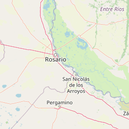
Map view of Predelta National Park

Use this park location map to pinpoint Predelta National Park in Argentina, understand its exact geographic position, and read its mapped placement within the surrounding landscape more clearly.

Pigeon | © OpenStreetMap contributors

Location context for Predelta National Park

Entre Ríos Province

Explore the visual identity of Predelta National Park, tracing its dynamic wetland ecosystems and rich protected area environments.

Discover Predelta National Park's Unique Delta Landscapes, Habitats, and Scenery

Visually explore Predelta National Park's captivating landscapes, showcasing its braided river channels, unique forested islands, vast freshwater lagoons, and seasonally flooded wetlands. These images provide essential geographic context for understanding the park's dynamic delta formation, diverse habitats, and critical role in conserving Argentina's expansive Paraná River wetland ecosystem.

Wide landscape of the Paraná River with muddy waters, dense green forests, and distant horizon under a partly cloudy sky

Park atlas

Compare Protected Landscapes and Delta Ecosystems Across the Paraná River Region

Discover Other National Parks Near Predelta National Park: Explore More Protected Areas

After exploring Predelta National Park's unique wetlands and river delta landscapes, continue your atlas discovery by browsing other protected areas throughout the surrounding Argentine region. Compare additional national parks and nature reserves to trace the geographic spread of delta ecosystems, gallery forests, and critical wetland conservation across the Paraná River basin.
National parkArgentina
6.9 km away#1 closest

Southwest

Islas de Santa Fe National Park: A National Park Defined by Paraná River Islands

Explore unique insular geography and wetland ecosystems.

Islas de Santa Fe National Park represents a remarkable protected landscape as Argentina's only exclusively insular national park, situated within the vast Paraná River flood valley. This area is characterized by a complex network of riverine islands, channels, and wetlands that create a unique terrain. The park's geography and ecosystems are intrinsically linked to the river's hydrological dynamics, offering significant insights into freshwater biodiversity and riparian habitats for dedicated atlas exploration.

Area
40.96 km²
Established
2010
Relief
Lowland
Climate
Subtropical
National parkEntre Ríos Province
217 km away#2 closest

East

El Palmar National Park: Protected Area Atlas and Geographic Exploration in Entre Ríos

Discover mapped park boundaries and regional landscape context.

El Palmar National Park offers a dedicated space for understanding protected landscapes within Argentina. As a designated national park situated in Entre Ríos Province, it serves as a crucial point for exploring mapped natural terrain and regional geography. This entry provides specific details on its protected area status and its contribution to the broader atlas of conservation lands in the Mesopotamia region.

Area
85 km²
Established
1966
IUCN
II
Access
Easy access
National parkRío Negro Department
236 km away#3 closest

East

Parque nacional Esteros de Farrapos e Islas del Río Uruguay: Protected Wetland Geography

Exploring the fluvial island and riverine terrain of Río Negro

This protected area represents an essential riverine ecosystem along the western frontier of Uruguay. The landscape comprises a complex layering of flood-prone plains, riparian forest edges, and silty soil formations that characterize the regional geography of the Río Uruguay basin.

Area
215.65 km²
Established
2008
Relief
Lowland
Scope
Terrestrial
Wildlife reserveRío Negro Department
About 255 km away#4 closest

East

Área de manejo de hábitats y/o especies Esteros y Algarrobales del Río Uruguay Protected Area Geography

Wildlife reserve in the Río Negro department with unique riparian corridors.

This wildlife reserve protects a unique transition zone where dry-forest Prosopis woodlands thrive alongside wetland esteros. Its mapped terrain reflects the intersection of two distinct ecoregions, creating a fragile landscape characterized by blanqueales soils, gallery forests, and river-fed floodplains within a larger protected conservation mosaic.

Area
15.5 km²
Relief
Lowland
Scope
Terrestrial
Water
Major water bodies
Protected areaPaysandú
About 294 km away#5 closest

East

Área protegida con recursos manejados Montes del Queguay: Geography and Protected Boundaries

Managed-resource landscape in the Paysandú river network

This protected area centers on a distinct floodplain basin in Paysandú, where silty soils and river confluence dynamics support a unique mosaic of riparian forest and wetland terrain. Explore the structural geography of this significant native woodland complex and its role within Uruguay's protected land system.

Area
434.1 km²
Established
1994
Relief
Lowland
Climate
Subtropical
National parkColonia Department
About 338 km away#6 closest

Southeast

Parque Nacional Aarón de Anchorena: Protected Geography and Riverine Landscape

An expansive arboretum and presidential estate in Colonia

Parque Nacional Aarón de Anchorena is a protected territory in southwestern Uruguay, defined by its position on the Río de la Plata estuary. The area encompasses an extensive arboretum, ornamental gardens, and riparian habitats that house unique animal populations. The site serves as a vital geographic anchor for the region, combining historic architecture with the broad, reflective horizons of the river coast.

Area
13.69 km²
Established
1908
Relief
Lowland
Climate
Temperate
Natural monumentFlores
About 348 km away#7 closest

East

Grutas del Palacio Natural Monument: Geological Landscape Map and Protected Area Context

Protected sandstone formations within the Flores region of central Uruguay

Grutas del Palacio represents a critical protected landscape in Flores, Uruguay, famous for its vaulted sandstone architecture and column-supported cavern structure. As an established natural monument, the site provides essential insights into Cretaceous sedimentary history and geoconservation. This record maps the natural features and territorial boundaries of this inland landmark, offering a structured look at its role in regional geography and geological heritage preservation.

Area
0.45 km²
Established
2013
Relief
Lowland
Climate
Subtropical
Wildlife reserveArtigas Department
About 356 km away#8 closest

Northeast

Área de manejo de hábitats y/o especies Rincón de Franquía: Protected Wildlife Reserve and Riverine Geography

Ecological mapping of Uruguay's northern borderland habitats

Área de manejo de hábitats y/o especies Rincón de Franquía protects an exceptionally rich floodplain environment at the confluence of the Uruguay and Cuareim rivers. As a central node in a tri-national ecological corridor, this reserve offers a deep look into the connectivity of riverine forest, riparian woodland, and seasonal wetlands in northern Uruguay's Artigas Department.

Area
12.29 km²
Established
2013
Relief
Lowland
Scope
Terrestrial

Common questions about visiting, size, designation, and location context for Predelta National Park

Predelta National Park FAQs for park facts, access, geography, and protected area context

Find quick answers about Predelta National Park, including protected-area facts, park geography, trail and visitor context, and how the park fits into its surrounding country and regional landscape.
MoriAtlas Explorer

Continue Your Protected Areas Search Across the Global Atlas

Deepen your exploration by continuing the structured search for national parks and protected areas worldwide. Utilize the comprehensive filtering capabilities to compare different conservation landscapes and refine your understanding of global park geography. Discover more about the distribution and characteristics of protected natural areas.

Global natural geography