
Beaches
Park geography
Structured data on regional landscape features and coastal terrain topography
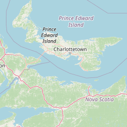
Geographic Profile and Mapped Boundaries of Prince Edward Island National Park
Prince Edward Island National Park features a diverse range of lowland terrain across the coast of Prince Edward Island. This geographic profile details the park area and perimeter, identifying key natural landforms such as dunes, beaches, and wetland habitats.
Related tags
coastal national parkred sand beachessand duneswetlandspiping plover habitat
Red sand beaches, coastal dunes and the literary legacy of Anne of Green Gables
Prince Edward Island National Park
Prince Edward Island National Park is a coastal protected area spanning approximately 60 kilometres along the northern shore of Prince Edward Island, fronting the Gulf of St. Lawrence in eastern Canada. Established in 1937, the park encompasses a narrow strip of land that ranges from several hundred metres to several kilometres in width, protecting roughly 27 square kilometres of sensitive beach, dune, and wetland habitats. The park is renowned for its distinctive red sand beaches, which are a signature feature of Prince Edward Island's coastline and a major part of the island's identity. Beyond its natural landscapes, the park holds significant cultural value as the steward of Green Gables, the 19th-century farm that inspired Lucy Maud Montgomery's beloved Anne of Green Gables novels. The park has been designated a Canadian Important Bird Area due to its critical role in protecting nesting habitat for the endangered piping plover.
- Location
- Canada
- Park type
- National park
- Established
- 1937
- Area
- 27 km²
Location overview
Coastal and island protected areas in Prince Edward Island, Canada
Prince Edward Island National Park Geographic Setting and Location
Prince Edward Island National Park is located within Canada in the Prince Edward Island region. Regional records classify the territory as a coastal and island park with no transboundary or marine designations.
- Countries
- Canada
- Regions
- Prince Edward Island
- Primary location
- Prince Edward Island
- Geographic setting
- Coastal · Island
Boundary and coordinates
Interactive boundary geometry and recorded area measurements
Prince Edward Island National Park Boundary Map and Spatial Extent
Mapped park outlines provide essential spatial context for examining protected boundaries across the terrain. Accompanying boundary facts detail recorded area metrics, coordinate limits, and geographic spans for the protected landscape.
- Boundary area
- 25.7 km²
- Boundary perimeter
- 135.9 km
- Northernmost point
- 46.5118° N
- Southernmost point
- 46.4031° N
- Easternmost point
- 62.6465° W
- Westernmost point
- 63.4805° W
- Geographic centre
- 46.4459° N, 63.0972° W
- North–south span
- 12.1 km
- East–west span
- 64.1 km
Terrain and natural features
Lowland relief and recorded coastal features within the park
Prince Edward Island National Park Terrain and Natural Features
Recorded terrain classifications indicate lowland relief alongside multiple protected coastal formations and interior elements. Linked feature cards supply names, types, and spatial relationships for each recorded natural feature.
Selected named natural features
Bays
Covehead Bay
Bays
St. Peters Bay
Islands
Robinsons Island
Bays
Brackley Bay
Capes
Brackley Point
Environmental setting
Temperate lowland terrain, coastal dunes, and seasonal water systems
Environmental Setting and Landscape Classifications of Prince Edward Island National Park
Stored landscape features and habitat types provide complementary perspectives on the physical setting of Prince Edward Island National Park. Recorded environmental categories connect directly to corresponding protected-area records within the atlas database.
- Relief
- Lowland
- Climate
- Temperate
- Water
- Major water bodies
- Forest cover
- Sparse forest
- Seasonality
- Seasonal
Landscape features
Beach · Coast · Dunes · Wetland · Grassland
Habitat types
Coastal habitat · Riverine habitat · Wetland · Dune habitat
Park atlas
Trace broader protected area geography and compare similar coastal landscapes across Atlantic Canada.
Explore Nearby National Parks and Protected Areas Beyond Prince Edward Island National Park
Browse a curated list of other national parks and protected areas near Prince Edward Island National Park, covering adjacent coastal regions and diverse conservation landscapes in Atlantic Canada. Expand your geographic understanding of protected areas by comparing features, scale, and ecological roles across the broader Maritime provinces.
National parkPrince Edward Island
About 35 km away#1 closest
Northwest

Pituamkek National Park Reserve: Prince Edward Island National Park Atlas Exploration
Mapped protected area and regional geographic context.
Pituamkek National Park Reserve offers a unique opportunity for atlas-driven discovery, focusing on its protected status as a national park on Prince Edward Island. The page details the park's geographic setting and its role within the broader landscape context of Canada. Explore its specific mapped boundaries and understand its contribution to the network of protected natural areas, providing essential data for geographic research and landscape analysis.
- Area
- 30 km²
- Established
- 2024
- IUCN
- II
- Relief
- Lowland
Wildlife reserveNew Brunswick
About 47 km away#2 closest
Southwest
Réserve nationale de faune du Cap-Jourimain: Protected Coastal Wetlands and Wildlife Maps
Essential geographic context for a strategic New Brunswick wildlife reserve
Examine the mapped boundaries and complex ecosystem transitions of Réserve nationale de faune du Cap-Jourimain. This federally protected area in New Brunswick offers a distinct look at coastal marshlands, tidal flats, and island topography situated at the narrowest point of the Northumberland Strait.
- Area
- 6.617 km²
- Established
- 1980
- IUCN
- IV
- Relief
- Lowland
Wildlife reserveNova Scotia
About 100 km away#3 closest
Southwest
Amherst Point Migratory Bird Sanctuary: Wetland Protected Landscape and Map Explorer
Nova Scotia Wildlife Reserve and Managed Marshland Habitat
Amherst Point Migratory Bird Sanctuary protects a significant freshwater marsh and ponded wetland network in Nova Scotia. This reserve is defined by its engineered diked impoundments and role as a crucial stopover for migratory birds in the Atlantic flyway, offering a clear window into managed wetland conservation and coastal marsh terrain.
- Area
- 4.33 km²
- Established
- 1947
- IUCN
- IV
National parkNew Brunswick
102 km away#4 closest
West
Kouchibouguac National Park: New Brunswick Protected Landscape Atlas
Mapped protected area boundaries and regional geography.
Kouchibouguac National Park is a designated national park offering a rich canvas for geographic discovery. This entry focuses on understanding its protected landscape, detailing its specific mapped boundaries within New Brunswick. It serves as a vital component for atlas exploration, providing the context needed to grasp the park's natural terrain and its significance within the regional geography.
- Area
- 238 km²
- Established
- 1969
- IUCN
- II
- Visitors
- 243.5K annual
Wildlife reserveNova Scotia
About 107 km away#5 closest
East
Sea Wolf Island National Wildlife Area: Protected Sandstone Cliffs and Seabird Sanctuary
Coastal maritime geography and nesting habitats in Nova Scotia
Sea Wolf Island National Wildlife Area constitutes a remote sandstone sanctuary in the Gulf of St. Lawrence. Characterized by steep, eroded cliff faces and isolated terrain, this Canadian protected area remains a significant site for colonial seabird nesting, specifically supporting populations of Great Cormorants and Razorbills within the Atlantic marine ecosystem.
- Area
- 0.76 km²
- Established
- 1982
- IUCN
- Ia
National parkNova Scotia
131 km away#6 closest
East
Cape Breton Highlands National Park: Mapped Protected Landscape in Nova Scotia
Discover its national park geography and natural terrain.
Uncover the protected landscape identity of Cape Breton Highlands National Park, a national park situated in Nova Scotia. This atlas-focused content details its mapped boundaries, regional geographic context, and natural terrain. It serves as a definitive resource for understanding the park's protected-area status and its contribution to the mapped natural landscapes of the region.
- Area
- 949 km²
- Established
- 1936
- IUCN
- II
- Visitors
- 277.2K annual
Wildlife reserveNew Brunswick
About 133 km away#7 closest
Southwest
Réserve nationale de faune de Shepody: Geographic Overview of a New Brunswick Wildlife Reserve
Coastal wetlands and protected intertidal geography
Located along the Bay of Fundy, Réserve nationale de faune de Shepody represents an essential network of salt marshes and freshwater habitats. This mapping analysis traces the intersection of tidal dynamics, riverine estuaries, and ancient sandstone formations that define this critical protected area in New Brunswick.
- Area
- 10.69 km²
- Established
- 1980
- IUCN
- IV
- Relief
- Lowland
Wildlife reserveNew Brunswick
About 140 km away#8 closest
Northwest
Île-du-Portage National Wildlife Area: Geographic Overview and Protected Island Mapping
A vital estuarine reserve on the New Brunswick coast
Study the coastal terrain of Île-du-Portage National Wildlife Area, an uninhabited island reserve situated at the junction of the Miramichi River and the Northumberland Strait. This overview focuses on the island's role as one of five National Wildlife Areas in New Brunswick, highlighting its significance within the broader estuarine geography and coastal maritime history of the Atlantic region.
- Area
- 3.49 km²
- Established
- 1979
- IUCN
- Ia
- Relief
- Lowland
MoriAtlas Explorer
Continue Exploring Prince Edward Island National Park's Geography and Mapped Boundaries
Deepen your understanding of Prince Edward Island National Park by exploring its detailed geography and mapped protected areas. This national park offers unique insights into coastal landscapes and their regional distribution. Use MoriAtlas to trace its boundaries and appreciate its specific place within the natural atlas of Canada's protected lands, providing a richer geographic context.
Browse next
Global natural geography
Explore related park routes
Explore MoriAtlas Global ParksBrowse All MoriAtlas ParksGlobal Park Map DiscoveryMoriAtlas: Browse All CountriesBrowse All MoriAtlas ContinentsNational Park Environment AtlasGrand Canyon National Park AtlasYellowstone National Park AtlasYosemite National Park Atlas and GeographySerengeti National Park AtlasGalápagos National Park Protected LandscapeBanff National Park Geography and AtlasKruger National Park Atlas EntryUluṟu-Kata Tjuṯa National Park AtlasExplore Uluru-Kata Tjuta National Park GeographyPlitvice Lakes National Park AtlasFiordland National Park Protected LandscapeGreat Smoky Mountains National Park AtlasAfghanistan National Parks and Protected AreasAlbania National Parks and Protected AreasAlgeria National Parks and Protected AreasAmerican Samoa National Parks and Protected AreasAndorra National Parks and Protected AreasAngola National Parks and Protected AreasAntarctica National Parks and Protected AreasAntigua and Barbuda Park List