
Mori Atlas logo
Protected landscapePřírodní park Bohdalovsko

Mapping the network of fishponds, wetland habitats, and highland terrain in the Vysočina Region.

Přírodní park Bohdalovsko: A Protected Landscape in the Bohemian-Moravian Highlands

Přírodní park Bohdalovsko represents a significant protected area within the Vysočina Region, covering over 6,000 hectares of the Bohemian-Moravian Highlands. This landscape is defined by an intricate mosaic of traditional fishponds, wet meadows, and forest remnants that support a unique variety of wetland flora and amphibian populations. Through its mapped boundaries and hydrological connectivity, the area provides a window into the evolution of Central European highland ecosystems shaped by long-term land management.

natural parkVysočina RegionBohemian-Moravian Highlandsfishpondswetland habitatswet meadows
A graphic illustration of a forest scene featuring tall, slender trees, large rocky outcrops, and soft, warm sunlight filtering through the canopy.

Přírodní park Bohdalovsko

Protected landscape

Park overview

Structured park overview, official facts, and landscape profile for Bohdalovsko Natural Park

Bohdalovsko Natural Park park facts, protected area profile, and essential visitor context

Review the core facts for Bohdalovsko Natural Park, including designation, size, terrain, visitor scale, habitats, and operating context in one park-focused overview.

About Bohdalovsko Natural Park

Bohdalovsko Natural Park is a landscape-level protected area in the western part of the Žďár nad Sázavou district, occupying the gently rolling terrain of the Bohemian-Moravian Highlands. Declared in 2001 by the Kraj Vysočina region, the park was set up to safeguard the combined natural, cultural, and historical character of a region where centuries of farming, pond-building, and forestry have produced a richly varied countryside.

The bedrock here belongs to the strážecké moldanubicum geological unit, with gneisses, paragneisses, and migmatites forming the underlying substrate, while the soils are mostly dystric cambisols and modal pseudogleys. Although the original beech and fir forests have largely been replaced by agricultural land and conifer plantations, the park preserves a remarkable network of fishponds, damp meadows, and small peatland remnants that developed where alder stands along streams and springs were cleared in earlier centuries. These wet habitats now form the ecological heart of the protected area.

Within the park boundary, several small, strictly protected sites add an extra layer of conservation significance. The natural reserve of Baba - V bukách safeguards one of the few surviving stands of original beech forest, while the natural monument Laguna u Bohdalova protects wetlands with a rich amphibian fauna. Five localities in and around the park have been incorporated into Europe's Natura 2000 network, including Dolní rybník u Újezda, Rybníky u Rudolce, Znětínské rybníky, and Fickův rybník. Together, these sites give Bohdalovsko a strong role in maintaining rare pond, wetland, and forest habitats in the Czech countryside.

Quick facts and research context for Bohdalovsko Natural Park

Bohdalovsko Natural Park lies in the Vysočina Region of the Czech Republic, within the Žďár nad Sázavou district, and covers approximately 6,080 hectares of the Bohemian-Moravian Highlands. It was officially declared on 2 July 2001 by the Kraj Vysočina regional authority to protect the landscape character of an area with notable biological and aesthetic value.

Geologically, the park belongs to the strážecké moldanubicum unit, dominated by gneisses, paragneisses, and migmatites. The predominant soils are dystric cambisols and modal pseudogleys, with local gleys. The landscape is defined by a mosaic of fishponds, meadows, wetlands, and forest patches, several of which are protected separately and are part of the Natura 2000 European network of important sites.

Protection and recognition

Examine documented terrestrial conservation frameworks and designation details.

Přírodní park Bohdalovsko Protection Status and Recognition Data

Přírodní park Bohdalovsko maintains a documented terrestrial protection status within its regional conservation framework. Official records compile available management scope and designation history for structured geographical analysis.

Protection details

Protection scope
Terrestrial
Transboundary protection
No
Park context

Deeper park guide and search-rich context for Bohdalovsko Natural Park

Bohdalovsko Natural Park history, landscape, wildlife, and travel context

Explore Bohdalovsko Natural Park through its history, landscape character, ecosystems, wildlife, conservation priorities, cultural context, and seasonal travel timing in a structured park guide built for atlas discovery and search intent.

Why Bohdalovsko Natural Park stands out

Bohdalovsko is best known for its dense network of fishponds and associated wetland habitats set within an undulating highland landscape. The park has become a key Czech locality for the tiny grass Colenanthus subtilis, special to exposed pond bottoms, accompanied by other rare aquatic and wetland species such as Tillaea aquatica, Carex bohemica, Potamogeton alpinus, and Utricularia minor. It is also valued for its strong amphibian populations, especially the great crested newt (Triturus cristatus) and the fire-bellied toad (Bombina bombina), and for the rich bird communities nesting along reedbeds and tall sedge stands surrounding the ponds. The combination of small-scale protected sites, Natura 2000 areas, and traditional fishponds makes the park a distinctive example of culturally shaped yet biologically rich Central European highland countryside.
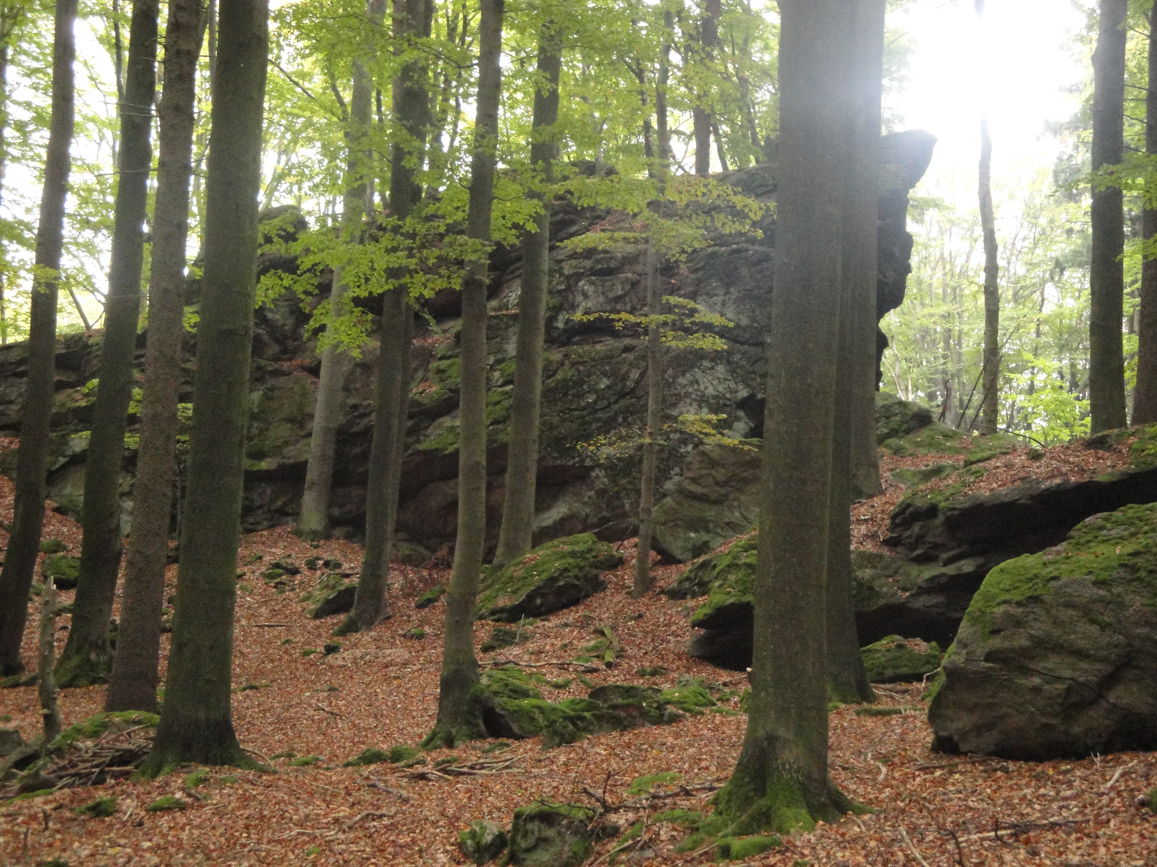
A large mossy rock formation rises amidst a dense forest with tall slender trees and a leaf-covered ground.
Baba Rock formation surrounded by deciduous forest in the Přírodní park Bohdalovsko.

Bohdalovsko Natural Park history and protected-area timeline

The history of Bohdalovsko is essentially a history of long-term human shaping of the landscape, followed by a more recent effort to protect the values that resulted from that interaction. Since the medieval colonization of the Bohemian-Moravian Highlands, the area's original beech and fir forests have been progressively cleared for fields, meadows, and pasture, while the remaining woodlands were converted, in many places, into spruce monocultures. Alder stands along streams and around springs were often felled, leaving space for damp meadows, peatland patches, and especially for the construction of fishponds of various sizes.

For centuries, local land use followed a traditional rhythm: meadows were mown each year, livestock was regularly pastured, fishponds were drained and reflooded in cycles to maintain productivity, and grain was even sown on the drained pond bottoms as a kind of natural fertilizer. This pattern held almost into the middle of the twentieth century and shaped the cultural as well as biological character of the landscape.

During the twentieth century, however, the region experienced a faster and more large-scale transformation. Fishponds were kept at high water levels, heavily fertilized, and artificially stocked with feed, small fields were consolidated and their boundary strips ploughed away, and wet meadows were either drained by melioration works and resown with species-poor grass mixtures, or abandoned entirely and left to overgrow. At the same time, forests became in effect "fields for spruce timber." Recognizing that even under these pressures many valuable habitats and rare species survive, the Kraj Vysočina regional authority declared Přírodní park Bohdalovsko on 2 July 2001 to protect the landscape character and the biological and aesthetic values of the area.

Bohdalovsko Natural Park landscape and geographic character

The park lies in the western part of the Bohemian-Moravian Highlands, a region of gently rolling uplands rather than dramatic peaks. Elevation changes are relatively modest, but the terrain offers a varied mosaic of small valleys, streams, pond basins, meadows, and woodland patches. The underlying geology of the strážecké moldanubicum, with its gneisses, paragneisses, and migmatites, gives the area a relatively acidic bedrock that shapes both soils and vegetation patterns.

Soils in the park are predominantly dystric cambisols and modal pseudogleys, with local gleys in the wettest places. These conditions have historically favored forests, but today forests occupy only a part of the area, often as spruce plantations on former agricultural land. Open landscape dominates elsewhere, with pastures, meadows, and especially fishponds of various sizes shaping the scenery. In places like the area near Březí nad Oslavou, landmark rocks such as the cliffs of the Baba nature reserve rise out of the otherwise soft highland topography, adding local relief and visual interest.

The fishponds themselves form an essential part of the present-day landscape. Where alder carrs were once cleared along streams and around springs, ponds now fill the landscape, and in many cases they have become so well established that they feel like an organic feature of the environment rather than a purely artificial one. Pond margins, wet meadows, small peatland remnants, and streams such as the Belfrídský potok are all integral elements of the park's landform character.

Bohdalovsko Natural Park ecosystems, habitats, and plant life

Despite the long history of forest clearance and agricultural conversion, Bohdalovsko still harbors a rich and unusual set of habitats. The most distinctive ecological feature is the network of fishponds and their exposed bottoms, which are colonized by a specialized community of small, often rare wetland plants. The tiny grass Colenanthus subtilis is the signature species of this habitat in the park, frequently accompanied by Tillaea aquatica and Carex bohemica.

Surrounding the ponds, reedbeds and tall sedge stands support a dense vegetation of Phragmites and Carex species, while small peatland patches host Menyanthes trifoliata, Naumburgia thyrsiflora, and Comarum palustre, along with insectivorous plants such as Utricularia minor in bog pools. Aquatic vegetation is unusually varied for a highland area, with notable populations of the alpine pondweed Potamogeton alpinus. Along stream corridors that retain their alder carrs, such as the Belfrídský potok, shade-tolerant species like Soldanella montana still survive in the moist understorey.

In spring, species-rich wet meadows come alive with flowering Dactylorhiza majalis and Pedicularis sylvatica, a reminder that even heavily transformed farmland can support valuable botanical diversity when traditional management persists. The small remnants of original broadleaf forest, especially the beech stands of the Baba - V bukách natural reserve, represent a separate but equally important habitat layer within the park, anchoring the area's forest biodiversity.

Bohdalovsko Natural Park wildlife and species highlights

Bohdalovsko is most notable for its amphibians, which are central to the conservation importance of several of the park's sites. The great crested newt (Triturus cristatus) and the fire-bellied toad (Bombina bombina) are particularly emphasized as species of conservation concern in the Natura 2000 sites associated with the park, with habitats such as Laguna u Bohdalova specifically protecting their breeding wetlands and surroundings.

The pond system also supports a rich birdlife. Reedbeds, tall sedge stands, and pond margins around the larger fishponds offer breeding habitat for a wide range of water-associated bird species, whose exact composition varies across the individual sites. The combination of open water, marshy edges, wet meadows, and nearby woodland creates a layered habitat structure that benefits both wetland and forest-edge bird communities.

Insect life, though less explicitly documented in source material, is closely tied to the park's botanical richness, including the insectivorous plants and the complex mosaic of meadows, pond margins, and peatlands. The overall wildlife profile of Bohdalovsko is therefore one of a heavily human-shaped landscape that nevertheless retains enough habitat diversity and traditional management to sustain significant populations of regionally important species.

Bohdalovsko Natural Park conservation status and protection priorities

Conservation in Bohdalovsko centers on protecting a landscape-level rather than purely site-level set of values. By declaring the area as a přírodní park (natural park), the Kraj Vysočina sought to preserve the combined natural, cultural, and historical character of the region, with explicit emphasis on its high biological and aesthetic value. This recognition acknowledges that the area's value comes not from wilderness but from a long-evolving balance of ponds, meadows, forests, and settlements.

Within the broader park, a stricter conservation framework is provided by several smaller protected areas and by Natura 2000. The natural reserve of Baba - V bukách protects one of the last remnants of original beech forest in the area, while the natural monument Laguna u Bohdalova safeguards wetlands important for amphibians. Five localities, namely Baba - V bukách, Dolní rybník u Újezda, Rybníky u Rudolce, Znětínské rybníky, and Fickův rybník, are part of the European Natura 2000 network and share a focus on rare pond-margin flora such as Colenanthus subtilis, Tillaea aquatica, and Carex bohemica, alongside amphibian species like Triturus cristatus and Bombina bombina.

The conservation challenge in Bohdalovsko is significant because much of the landscape is privately owned and actively managed. Continued intensive fish farming, melioration of wet meadows, abandonment of less accessible grasslands, and conversion of forests to spruce monocultures all pressure the very habitats that give the park its value. Maintaining the mosaic of fishponds, traditional meadows, and surviving broadleaf forest is therefore central to the park's long-term conservation role.

Bohdalovsko Natural Park cultural meaning and human context

Bohdalovsko's cultural identity is inseparable from its working landscape. The villages whose cadastres fall within the park, including Bohdalov, Březí nad Oslavou, Chroustov, Kotlasy, Kyjov, Matějov, Milíkov, Nové Veselí, Pavlov, Pokojov, Radostín nad Oslavou, Rudolec, Starý Telečkov, Újezd u Žďáru nad Sázavou, and Znětínek, together define a community whose land use has shaped the area for centuries. Traditional hay meadows, regular grazing of livestock including small stock like sheep, and the seasonal cycle of draining and refilling fishponds for fish production are all part of this cultural pattern.

The deliberate use of drained pond beds for sowing grain, as a way of naturally fertilizing the ponds before reflooding, is a particularly distinctive local practice. Although many of these traditions have weakened in the twentieth century, they remain a defining element of the landscape's historical and cultural character, and are part of what the park's protection aims to safeguard alongside natural values.

Top sights and standout views in Bohdalovsko Natural Park

Bohdalovsko's standout qualities lie in the way a highland cultural landscape has retained, despite extensive change, an exceptional network of fishponds and associated wetlands. The presence of multiple Natura 2000 sites within a single protected landscape, all interconnected by shared hydrology and land-use history, is unusual and gives the park both ecological coherence and conservation weight.

Equally distinctive are the surviving fragments of original beech forest such as those in Baba - V bukách and the orchid-rich wet meadows that flower with Dactylorhiza majalis and Pedicularis sylvatica each spring. Together with rare pond-bottom specialists like Colanathus subtilis, amphibian strongholds such as Laguna u Bohdalova, and the cultural backdrop of traditional fish-farming villages, Bohdalovsko offers a compact but richly layered example of Central European highland conservation.

Best time to visit Bohdalovsko Natural Park

Spring and early summer are when Bohdalovsko is likely to feel most alive for a visitor interested in its natural character. In May, the wet meadows come into flower, with orchids such as Dactylorhiza majalis and the small Pedicularis sylvatica visible on traditionally managed grasslands. By early summer, the ponds and their margins are fully vegetated, reedbeds and tall sedge stands are at their densest, and amphibians are most active around sites like Laguna u Bohdalova.

Late summer and autumn bring a quieter, more reflective atmosphere, when exposed pond bottoms can be explored on foot as water levels drop, and when the landscape's mosaic of forests, fields, and ponds is most visible from higher ground. Winter visits offer a stark, minimal atmosphere, though much of the area's biological interest is then hidden. Across all seasons, the working landscape of fishponds, meadows, and small villages remains a constant backdrop.

Monthly climate preview

Long-term representative point measurements for temperature and precipitation patterns

Přírodní park Bohdalovsko Climate Normals and Annual Temperature Rhythm

Representative coordinate records show sustained sub-zero winter minimums alongside warm summer peaks reaching average maximums near thirty degrees Celsius. Detailed monthly climatology data provides deeper insight into precipitation rates and multi-year temperature distributions across the protected terrain.
Annual mean7 °C
-4 °C18 °C
Jan-4°
Feb-2°
Mar
Apr
May12°
Jun16°
Jul18°
Aug18°
Sep13°
Oct
Nov
Dec-2°
Warmest month
July

18.1 °C

Coolest month
January

-3.6 °C

Wettest month
July

2.9 mm/day

Driest month
February

1.3 mm/day

Park location guide

Geography guide, regional context, and park location map for Bohdalovsko Natural Park

Bohdalovsko Natural Park park geography, regions, and map view in Czechia

Understand where Bohdalovsko Natural Park sits in Czechia through a broader geographic reading of the surrounding landscape, nearby location context, and its mapped position within the national park landscape.

How Bohdalovsko Natural Park fits into Czechia

Czech Republic is a landlocked Central European country with a population of approximately 10.9 million people. The nation was established as an independent state on January 1, 1993, following the dissolution of Czechoslovakia. Its capital and largest city is Prague, with other major urban centers including Brno, Ostrava, Plzeň, and Liberec.

Wider geography shaping Bohdalovsko Natural Park in Czechia

The Czech Republic is a landlocked country in Central Europe. It is bordered by Germany to the west, Austria to the south, Poland to the northeast, and Slovakia to the southeast. The landscape is predominantly hilly, with the territory covering 78,871 square kilometers.

Map view of Bohdalovsko Natural Park

Use this park location map to pinpoint Bohdalovsko Natural Park in Czechia, understand its exact geographic position, and read its mapped placement within the surrounding landscape more clearly.

Pigeon | © OpenStreetMap contributors

Location context for Bohdalovsko Natural Park

Vysočina Region

Visual reference for fishponds, wetland habitats, and protected terrain

Přírodní park Bohdalovsko Photos and Mapped Highland Landscapes

Visual documentation reveals the undulating topography, dense fishpond networks, and wetland vegetation defining Přírodní park Bohdalovsko. Examining these protected area views provides deeper insight into the highland terrain, forest remnants, and aquatic habitats characterizing the region.

A large mossy rock formation rises amidst a dense forest with tall slender trees and a leaf-covered ground.

A brown-framed rectangular information board for Přírodní park Bohdalovsko standing in a wooded area with a tree to the left bearing trail markers.

Park atlas

Compare regional upland terrain, wetland networks, and connected conservation areas.

Explore Other Parks Near Přírodní park Bohdalovsko and Surrounding Protected Landscapes

Browse neighboring protected areas and regional reserves connected to the Bohemian-Moravian Highlands. Expanding the geographic scope reveals broader patterns across highland pond basins and wetland habitats.
A soft watercolor painting of a serene landscape featuring a calm lake surrounded by trees and gentle rolling hills in the background.
Natural monumentKraj Vysočina
About 10 km away#1 closest

North

Rozštípená skála Natural Monument: Geological Mapping of the Vysočina Gneiss Outcrops

Protected rocky terrain in the Bohemian-Moravian Highlands

Rozštípená skála features a striking gneiss cliff formation split by long weathered fissures. Located in the Vysočina Region, this natural monument provides a focal point for understanding the geological patterns and river valley landscapes that define the mid-altitude terrain of the Czech Republic.

Area
0.008 km²
Established
1974
IUCN
III
Relief
Upland
A soft watercolor illustration of a landscape with rolling hills, a meandering stream, and wooded areas against a pale sky.
Natural monumentVysočina Region
About 10 km away#2 closest

Southeast

Rasuveň Natural Monument: Protected Forest Terrain in the Czech Vysočina Region

Mapping upland woodland and fir-beech conservation areas

Rasuveň protects a meaningful remnant of fir-beech forest in the Czech-Moravian Highlands. This natural monument, situated in the Vysočina Region, provides a quiet example of mature upland woodland conservation. Its geographic profile is defined by rolling ridges and crystalline bedrock, offering a dedicated space for observing natural forest structures within an increasingly managed agricultural landscape.

Area
0.207 km²
Established
1989
IUCN
IV
Relief
Upland
A watercolor painting showing a soft landscape of rolling hills, grassy meadows, and patches of vegetation in a pastel color palette.
Natural monumentKraj Vysočina
About 17 km away#3 closest

Northeast

Sklenské louky Natural Monument: Wetland Landscapes in Kraj Vysočina

Highland geography and protected peatland habitats

Sklenské louky functions as a concentrated nature monument within the Kraj Vysočina region, preserving vital moisture-loving vegetation and peat-based ecosystems. The terrain features a characteristic mix of open meadows and spruce groupings, illustrating the diverse landscape character of the Bohemian-Moravian Highlands. This protected area provides a clear view into the region's unique upland hydrological and botanical patterns.

Area
0.063 km²
Established
1985
IUCN
IV
Relief
Upland
Natural monumentKraj Vysočina
About 21 km away#4 closest

Northeast

Vávrova skála Natural Monument: Geological Exploration in the Kraj Vysočina Region

Metamorphic rock outcrops and highland protected habitats

Vávrova skála stands as a protected natural monument near Pohledec, showcasing a distinct orthogneiss formation shaped by Quaternary weathering. This site serves as a vital reference for the geological diversity of the Bohemian-Moravian highlands, protecting rare summit heath and dry grassland within the larger Žďárské vrchy protected landscape.

Area
0.001 km²
Established
1983
IUCN
III
Relief
Upland
Watercolor illustration of a peaceful landscape featuring soft-colored hills, green trees, and an open foreground on a white background.
Natural monumentKraj Vysočina
About 25 km away#5 closest

Southwest

Na Kopaninách Natural Monument and Protected Meadow Geography in the Vysočina Region

A vital habitat for rare Bohemian-Moravian grassland flora.

Situated at an elevation of 550 to 570 meters, Na Kopaninách represents a critical fragment of traditional rural landscape. The area consists of a small mosaic of hay meadows and communal pasture, playing a central role in national rescue programs for rare gentian populations. Its north-facing terrain and nutrient-poor soils support a specialized botanical community that highlights the importance of small-scale habitat protection.

Area
0.01 km²
Established
1986
IUCN
IV
Relief
Lowland
A horizontal watercolor painting depicting a soft, scenic view of hills with rocky outcrops in the foreground and a forested landscape in the distance.
Protected areaCzechia
About 25 km away#6 closest

Northeast

Malinská skála: Geomorphological Landmark and Viewpoint in the Czech-Moravian Highlands

Protected gneiss rock group and mountain ridge geography

Rising as a striking summit in the Žďárské vrchy, Malinská skála presents a concentrated group of named gneiss towers reaching 20 meters in height. The site functions as a geological monument, preserving classic examples of frost-shattered boulder streams and high-elevation landforms. With its panoramic vantage points, it serves as a central point for mapping the topography of the surrounding Czech upland ridges.

Area
0.058 km²
Established
1987
Relief
Mountain
Climate
Temperate
Natural monumentKraj Vysočina
About 25 km away#7 closest

Southwest

Urbánkův palouk Natural Monument: Protected Highland Landscape and Meadow Geography

Preserved peat meadow terrain in the Czech Republic.

Urbánkův palouk serves as a critical natural monument in Kraj Vysočina, protecting a rare fragment of wet and peat-influenced meadow habitat. Positioned on a highland plateau at 622 meters, this site functions as an ecologically dense refuge for threatened plant species within the traditional Czech-Moravian Highland landscape.

Area
0.01 km²
Established
1990
IUCN
IV
Relief
Lowland
A soft watercolor illustration featuring rolling hills in pink and green tones with stylized coniferous trees, set against a white background.
Natural monumentPardubický kraj
About 31 km away#8 closest

Northeast

Rybenské Perničky: Natural Monument and Geological Landmark of the Bohemian-Moravian Highlands

Geological rock outcrops and protected upland terrain in the Pardubice Region

Investigate the geological structure of Rybenské Perničky, a protected natural monument featuring unique orthogneiss outcrops and characteristic bowl-shaped weathering basins. Situated in the Pardubice Region, this site offers a focused look at the crystalline rock formations and undulating plateau terrain of the Bohemian-Moravian Highlands, providing essential geographic context for this noteworthy natural landmark.

Area
0.141 km²
Established
1980
Relief
Upland
Climate
Temperate

Common questions about visiting, size, designation, and location context for Bohdalovsko Natural Park

Bohdalovsko Natural Park FAQs for park facts, access, geography, and protected area context

Find quick answers about Bohdalovsko Natural Park, including protected-area facts, park geography, trail and visitor context, and how the park fits into its surrounding country and regional landscape.
MoriAtlas Explorer

Continue Your Protected Areas Search Across the Global Atlas

Deepen your exploration by continuing the structured search for national parks and protected areas worldwide. Utilize the comprehensive filtering capabilities to compare different conservation landscapes and refine your understanding of global park geography. Discover more about the distribution and characteristics of protected natural areas.

Global natural geography