
Mori Atlas logo
Protected landscapePřírodní park Čížovky

Mapping the wetlands, wooded valleys, and diverse aquatic habitats of this traditional Bohemian countryside refuge

Přírodní park Čížovky: A Detailed Geographic Atlas of the Protected Landscape in Mladá Boleslav District

Přírodní park Čížovky encompasses a rich mosaic of water bodies, meadows, and forested slopes across the Mladá Boleslav District. This protected landscape is defined by the Křesovský potok stream system and the prominent ridge of Křemenice, which forms the eastern edge of the Chloumecký hřbet. Our atlas data offers a clear view of these varied natural habitats, providing insight into the area's ecological continuity and traditional rural land use.

nature parkwetlandspondswet meadowsorchardswooded valleys
A flat, vector-style illustration of a landscape with a waterfall flowing down cliffs into a pool, surrounded by a coniferous forest, rolling hills, and some tree stumps in the foreground.

Přírodní park Čížovky

Protected landscape

Park overview

Structured park overview, official facts, and landscape profile for Přírodní park Čížovky

Přírodní park Čížovky park facts, protected area profile, and essential visitor context

Review the core facts for Přírodní park Čížovky, including designation, size, terrain, visitor scale, habitats, and operating context in one park-focused overview.

About Přírodní park Čížovky

Přírodní park Čížovky is a medium-sized nature park in the Czech Republic that protects a culturally and ecologically significant slice of the Bohemian rural landscape. It was declared in 1998 by the municipal authority of Mladá Boleslav and lies within the Mladá Boleslav district of the Central Bohemian Region, encompassing the surroundings of the villages of Petkovy, Domousnice and Lhotky. The protected area covers roughly 386 square kilometers and rises from about 228 meters to 336 meters above sea level.

The defining feature of the park is its landscape mosaic. A series of ponds fed by the Křesovský potok stream is embedded in a network of wetlands, wet meadows, drier grasslands and remains of old fruit orchards, while the surrounding slopes are covered by forest. This combination of aquatic, wetland, meadow and woodland habitats in close proximity gives the park a particularly high ecological density, unusual even for protected countryside in Central Bohemia.

The park also has a clear geological and topographical signature. The hill of Křemenice, the easternmost summit of the prominent Chloumecký hřbet ridge, rises within the park and offers an elevated vantage point over the surrounding lowlands. Together with the broader mosaic of land use, this gives Čížovky a layered character: a working rural landscape on one hand, and a refuge for species-rich biotopes on the other.

Because the area saw only limited post-war construction, the older settlement pattern, small-scale agricultural land use, and historical structures such as the old mill still survive. This combination of intact landscape structure and diverse habitats is the core reason the area was given protected status and remains the basis of its conservation value today.

Quick facts and research context for Přírodní park Čížovky

Přírodní park Čížovky is a nature park in the Mladá Boleslav district of the Central Bohemian Region, Czech Republic. It was designated in 1998 by the local authority of Mladá Boleslav and covers an area of roughly 386 square kilometers. The protected zone centers on the villages of Petkovy, Domousnice and Lhotky.

The park lies between about 228 and 336 meters above sea level, with its highest point being Křemenice, the eastern termination of the Chloumecký hřbet ridge. Its character is shaped by the Křesovský potok brook, a chain of small ponds, wet meadows and the wooded slopes that line the stream valleys, all set within a sparsely populated rural landscape.

Protection and recognition

Documented conservation parameters, administrative context, and recognition records

Přírodní park Čížovky Protection Status and Terrestrial Area Scope

Přírodní park Čížovky maintains a documented terrestrial protection scope without imported international recognition sources. Structured administrative records outline the governance framework and official designation history for this protected landscape.

Protection details

Protection scope
Terrestrial
Transboundary protection
No
Park context

Deeper park guide and search-rich context for Přírodní park Čížovky

Přírodní park Čížovky history, landscape, wildlife, and travel context

Explore Přírodní park Čížovky through its history, landscape character, ecosystems, wildlife, conservation priorities, cultural context, and seasonal travel timing in a structured park guide built for atlas discovery and search intent.

Why Přírodní park Čížovky stands out

Přírodní park Čížovky is best known for its richly varied wetland and aquatic habitats, including ponds fed by the Křesovský potok, surrounding marshes, and species-rich wet meadows. These habitats are closely interwoven with fragments of old orchards and forested valleys, producing a particularly diverse ecological mosaic in a single protected landscape. The park is also recognized for its population of breeding wetland and woodland birds, rare amphibians, and a bat colony roosting in a historic mill building beneath one of the pond dams. Together with the elevated viewpoint of Křemenice at the end of the Chloumecký hřbet, these features give the park a strong identity as a low-disturbance Bohemian countryside refuge.
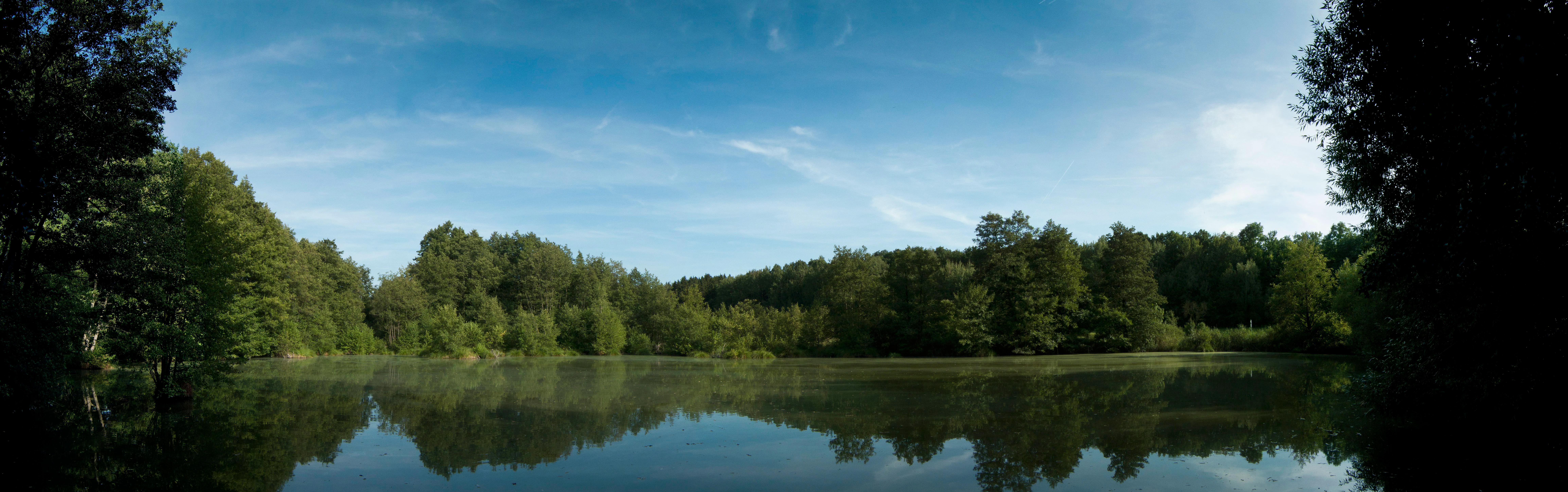
A panoramic view of a calm water reservoir surrounded by dense forest under a clear blue sky, with reflections of trees on the water surface.
A view of the reservoir in Přírodní park Čížovky.

Přírodní park Čížovky history and protected-area timeline

Přírodní park Čížovky was officially declared in 1998 by the municipal authority of Mladá Boleslav. The designation followed recognition that the countryside around the villages of Petkovy, Domousnice and Lhotky retained a largely unaltered rural character, with sparse habitation and very limited post-war development, even as much of the surrounding Bohemian landscape underwent more intensive change.

The underlying reason for protection was the survival of a coherent mosaic of habitats, including the pond chain fed by the Křesovský potok, surrounding wetlands, meadows, old orchards and forested valleys, along with the cultural landscape elements that supported them. Declaring the area as a přírodní park, a regional category of protected landscape in the Czech system, was intended to preserve this combination of natural and rural values against further fragmentation or redevelopment.

Přírodní park Čížovky landscape and geographic character

The landscape of Přírodní park Čížovky is shaped by a gently rolling to hilly terrain in the Bohemian countryside. Elevations within the park range from roughly 228 to 336 meters above sea level. The most prominent topographic feature is Křemenice, the easternmost high point of the Chloumecký hřbet ridge, which forms a noticeable hill at the edge of the protected area and overlooks the surrounding lowlands.

The lower ground is dominated by a chain of water bodies fed by the Křesovský potok stream. Around these ponds the land flattens into a patchwork of wet and dry meadows, marshy ground, and small remnants of old orchards that still bear witness to the area's traditional rural land use. The stream valleys that connect the ponds are framed by forested slopes, giving the park a strongly three-dimensional character with clear contrasts between open water, open meadow and enclosed woodland.

Because the modern footprint of buildings and infrastructure is limited, the visual landscape remains close to its historical form. Small villages, scattered farmsteads, the water network, and the wooded ridges together produce a classic Central Bohemian rural panorama, with the Křemenice ridge serving as a natural landmark above the mosaic of fields, meadows and ponds.

Přírodní park Čížovky ecosystems, habitats, and plant life

The ecological identity of Přírodní park Čížovky is rooted in the close interplay between aquatic, wetland, grassland and woodland habitats. The main hydrological backbone is the Křesovský potok, whose waters sustain a series of small ponds and adjoining marshy ground. Around these water bodies the park preserves a range of meadow types, including thistle meadows, fescue meadows and sedge meadows, each supporting different plant communities.

A particularly notable botanical dimension is the diversity of wetland and aquatic plants. Species recorded in the park include marsh fern, shining pondweed, horned pondweed, pepper-saxifrage relatives such as Silaum silaus, field wormwood, several sedge species including mountain sedge, branched sedge and cyperus sedge, common centaury, northern bedstraw, marsh valerian, Cassubian vetch, and hog's fennel. This floristic richness reflects a long continuity of low-intensity land use.

The wooded valley slopes and remnant old orchards add further habitat diversity. The mosaic pattern of small, structurally distinct habitats within a relatively compact area is what gives the park its strongest ecological character and supports the unusually varied fauna also recorded here.

Přírodní park Čížovky wildlife and species highlights

The mosaic of habitats in Přírodní park Čížovky supports a wide range of animal life. The ponds, wetlands and wet meadows are particularly important for amphibians, several species of which are considered threatened and occur in the park. The water bodies and their reedbeds also host breeding waterbirds such as the common coot.

The mix of forest, orchards and open water attracts a diverse bird community. Forest and woodland species include the great spotted woodpecker, lesser spotted woodpecker and red-backed shrike. Wetland and stream-side species include the common kingfisher, white wagtail and grey wagtail, while scrub and reed-edge habitats support garden warbler and sedge warbler. The variety of these breeding birds across habitats is one of the park's notable wildlife features.

The park is also significant for bats. A bat colony roosts in an old mill situated beneath the dam of one of the ponds, using the historic building as a shelter while feeding over the surrounding water and meadows. Together, the amphibian, bird and bat populations give the park a strong faunal profile that reflects the quality and connectivity of its habitats.

Přírodní park Čížovky conservation status and protection priorities

The conservation value of Přírodní park Čížovky lies in the preservation of an unusually well preserved Bohemian rural landscape and the dense habitat mosaic it contains. As a přírodní park, the area is protected at a regional level for its combined natural and cultural landscape character. The designation aims to maintain the existing low-intensity land use, the integrity of the pond and stream system, and the surrounding meadows, orchards and forests.

A central conservation focus is the wetland system centered on the Křesovský potok and its associated ponds. These water bodies and adjacent wet meadows harbor several rare plant species and provide breeding habitat for amphibians and birds. The survival of these habitats in a connected state, rather than as isolated fragments, is a key element of the park's ecological importance.

Equally important is the continuity of traditional land use. The remnants of old orchards, the network of small meadows, and the existence of historic structures such as the mill that shelters the bat colony all contribute to habitat quality. Maintaining this balance between human land use and biodiversity is the main long-term conservation challenge and goal for the park.

Přírodní park Čížovky cultural meaning and human context

The cultural dimension of Přírodní park Čížovky is closely tied to its rural Bohemian character. The protected area encompasses a landscape of small villages, scattered farmsteads and a long-established pattern of ponds, meadows, orchards and woodland that has shaped local life for generations. The minimal post-war construction noted in the area's history has helped preserve a settlement pattern that still reflects this older rural organization.

Historic buildings remain part of the living landscape. An old mill located below the dam of one of the ponds is not only a cultural landmark but also an important wildlife site, providing roosting space for a colony of bats. The combination of working agricultural land, historic structures and natural habitats gives the park a character in which cultural heritage and ecological value are tightly interwoven.

Top sights and standout views in Přírodní park Čížovky

The standout qualities of Přírodní park Čížovky include its dense mosaic of ponds, wetlands, meadows, old orchards and wooded valleys within a single protected area, the conspicuous hill of Křemenice marking the end of the Chloumecký hřbet, the species-rich wet meadows and aquatic flora, and the unusually varied breeding bird and amphibian fauna supported by the habitat mosaic. The bat colony in the historic mill beneath a pond dam is a distinctive feature linking the park's cultural and natural heritage.

Best time to visit Přírodní park Čížovky

The park is best appreciated in late spring and early summer, when the pond and meadow habitats are most active and the mix of wet meadows, reedbeds and woodland is in full seasonal use by breeding birds and amphibians. Late spring is a particularly good period for observing wetland flora and the bird communities around the Křesovský potok chain of ponds. Autumn can also be rewarding for a quieter experience of the landscape and the views from the Křemenice ridge over the surrounding countryside.

Monthly climate preview

Long-term monthly temperature averages and precipitation patterns for Přírodní park Čížovky

Přírodní park Čížovky Climate Normals and Measured Temperature Rhythm

Representative coordinate measurements from 1991 to 2020 record the annual temperature progression and monthly precipitation rates across Přírodní park Čížovky. Reviewing the complete twelve-month climatology dataset reveals broader seasonal variations and detailed temperature ranges.
Annual mean8 °C
-3 °C19 °C
Jan-3°
Feb-2°
Mar
Apr
May13°
Jun17°
Jul19°
Aug18°
Sep13°
Oct
Nov
Dec-2°
Warmest month
July

18.7 °C

Coolest month
January

-3.1 °C

Wettest month
July

2.9 mm/day

Driest month
April

1.3 mm/day

Park location guide

Geography guide, regional context, and park location map for Přírodní park Čížovky

Přírodní park Čížovky park geography, regions, and map view in Czechia

Understand where Přírodní park Čížovky sits in Czechia through a broader geographic reading of the surrounding landscape, nearby location context, and its mapped position within the national park landscape.

How Přírodní park Čížovky fits into Czechia

Czech Republic is a landlocked Central European country with a population of approximately 10.9 million people. The nation was established as an independent state on January 1, 1993, following the dissolution of Czechoslovakia. Its capital and largest city is Prague, with other major urban centers including Brno, Ostrava, Plzeň, and Liberec.

Wider geography shaping Přírodní park Čížovky in Czechia

The Czech Republic is a landlocked country in Central Europe. It is bordered by Germany to the west, Austria to the south, Poland to the northeast, and Slovakia to the southeast. The landscape is predominantly hilly, with the territory covering 78,871 square kilometers.

Map view of Přírodní park Čížovky

Use this park location map to pinpoint Přírodní park Čížovky in Czechia, understand its exact geographic position, and read its mapped placement within the surrounding landscape more clearly.

Pigeon | © OpenStreetMap contributors

Location context for Přírodní park Čížovky

Mladá Boleslav District

Explore photographic records of ponds, forested valleys, and protected terrain.

Visualizing Přírodní park Čížovky: Landscapes, Habitats, and Scenery

Photographs capture the diverse wetland habitats, wooded ridges, and traditional rural mosaic defining Přírodní park Čížovky. Visual documentation reveals the distinct topography and ecological character of this protected Bohemian landscape.

A panoramic view of a calm water reservoir surrounded by dense forest under a clear blue sky, with reflections of trees on the water surface.

A sunny, partially cleared forest area with cut tree stumps and debris in the foreground, bordered by a standing forest of coniferous and deciduous trees under a clear blue sky.

Park atlas

Compare surrounding Central Bohemian landscapes and regional protected natural habitats

Explore Protected Areas and Parks Near Přírodní park Čížovky

Continue geographic comparison by browsing other protected areas situated near Přírodní park Čížovky and the wider Central Bohemian region. Expanding the park route reveals similar wetland valleys, wooded ridges, and traditional rural reserves.
A watercolor painting showing a panoramic view of a wetland area with reeds in the foreground and a forested ridge in the background.
Protected landscapeMladá Boleslav District
About 6.7 km away#1 closest

West

Přírodní park Chlum: Exploring the Geography of a Protected Czech Woodland Ridge

Mladá Boleslav District protected landscape analysis

Examine the structural character of Přírodní park Chlum, an asymmetric horst ridge in the Czech Republic that serves as a vital ecological corridor. This protected landscape preserves rare forest communities and geological features, providing essential habitat continuity across the surrounding agricultural lowlands of the Mladá Boleslav District.

Area
13.19 km²
Established
2000
Relief
Upland
Climate
Temperate
Natural monumentKrálovéhradecký kraj
About 14 km away#2 closest

North

Meziluží Natural Monument: Mapping Protected Landscape Geography in Královéhradecký Kraj

A study of sandstone terrain and historic conservation within the Bohemian Paradise

Meziluží provides a detailed look at the geography of small-scale protected sites in the Czech Republic. By analyzing its steep sandstone slopes and traditional orchard-pasture land use, users gain a clearer understanding of the complex relationship between regional geology and botanical conservation history in the Bohemian Paradise area.

Area
0.015 km²
Established
1997
Relief
Upland
Scope
Terrestrial
Natural monumentStředočeský kraj
About 15 km away#3 closest

North

V Dubech Natural Monument: Protected Wetland Landscapes and Geography in Czech Republic

A compact wetland mosaic in the Středočeský kraj region

V Dubech is a protected natural monument situated at the base of the Příhrazské skály sandstone formations in the Czech Republic. This site preserves a valuable wetland mosaic, including base-rich peat meadows and alder woodlands that support rare species. The park provides an essential look at the localized, water-dominated geography within the broader context of the Bohemian Paradise protected landscape.

Area
0.047 km²
Established
1998
IUCN
III
Relief
Lowland
A minimalist watercolor painting showing a horizontal landscape with a pond in the foreground, green fields in the midground, and soft rolling hills in the background.
Natural monumentKrálovéhradecký
About 15 km away#4 closest

East

Rybník Jíkavec Natural Monument: Mapping Protected Wetland Habitats in Královéhradecký

A preserved pond and meadow landscape in central Czechia

Rybník Jíkavec protects a compact cluster of wetland habitats, including open water and sedge-rich meadows within the Královéhradecký region. This nature monument highlights the ecological importance of traditionally managed fishponds and their role in maintaining rare inland marsh flora across the local Bohemian countryside.

Area
0.073 km²
Established
1998
IUCN
IV
Relief
Lowland
Watercolor painting showing a river, grassy banks, scattered trees, and distant hills
Protected landscapeCzechia
About 15 km away#5 closest

Northeast

Bohemian Paradise Protected Landscape: Discover Czech Republic's Sandstone Geology and Park Boundaries

Mapped sandstone formations and historic regional geography.

Delve into Bohemian Paradise, a protected landscape in the Czech Republic celebrated for its dramatic sandstone rock formations and ancient castles. This detailed entry provides context on its unique geological character, the extent of its protected boundaries, and its significant position within the regional geography. Explore the mapped terrain and understand the atlas value of this historic protected area.

Area
181.17 km²
Established
1955
IUCN
V
Relief
Upland
A soft watercolor illustration depicting a riverbank with light green trees and a prominent rocky outcrop or cliff face near the water.
Natural monumentCentral Bohemian Region
About 16 km away#6 closest

Northwest

Skalní sruby Jizery Natural Monument: Sandstone Landforms and River Geography

Protected riparian sandstone terrain in the Central Bohemian Region

This natural monument protects a rare geological formation along the Jizera River, where lateral erosion has created an extensive sandstone rock shelter. The site showcases advanced pseudokarst weathering and supports a dense concentration of botanical and avian diversity within its two-hectare boundary in the Central Bohemian Region.

Area
0.02 km²
Established
1979
IUCN
III
Relief
Upland
Watercolor illustration of sandstone rock towers and coniferous trees in a landscape setting with a light color palette.
Nature reserveKrálovéhradecký kraj
About 17 km away#7 closest

Northeast

Prachovské skály Nature Reserve: Geologic Atlas of Bohemian Sandstone Formations

Mapped sandstone towers and protected forest terrain in Královéhradecký kraj

Prachovské skály consists of a concentrated sandstone massif characterized by towering pinnacles and labyrinthine gorges. This nature reserve serves as a prime example of sedimentary erosion in the Bohemian Paradise region, offering a distinct landscape profile that stands in sharp contrast to the surrounding agricultural plains of the Czech Republic.

Area
2.624 km²
Established
1928
IUCN
IV
Visitors
300K annual
Natural monumentSemily District
About 18 km away#8 closest

North

Vústra Natural Monument: Mapping the Protected Wetland Landscapes of the Semily District

A concentrated botanical and geological sanctuary in the Bohemian Paradise

Vústra is a highly localized natural monument in the Semily District that preserves a vital wetland complex including a pond and calcareous fen. Surrounded by characteristic sandstone rock towers and alder-spruce forests, the site serves as a vital ecological anchor within the wider Bohemian landscape. This detail page traces the specific boundaries and topographical features that define this protected monument.

Area
0.023 km²
Established
1996
IUCN
IV
Relief
Lowland

Common questions about visiting, size, designation, and location context for Přírodní park Čížovky

Přírodní park Čížovky FAQs for park facts, access, geography, and protected area context

Find quick answers about Přírodní park Čížovky, including protected-area facts, park geography, trail and visitor context, and how the park fits into its surrounding country and regional landscape.
MoriAtlas Explorer

Continue Your Protected Areas Search Across the Global Atlas

Deepen your exploration by continuing the structured search for national parks and protected areas worldwide. Utilize the comprehensive filtering capabilities to compare different conservation landscapes and refine your understanding of global park geography. Discover more about the distribution and characteristics of protected natural areas.

Global natural geography