
Mori Atlas logo
Protected landscapePřírodní park Heřmanův Městec

Analyzing the convergence of 18th-century ornamental design and natural foothill woodland terrain

Přírodní park Heřmanův Městec: A Protected Landscape in the Chrudim District Foothills

Přírodní park Heřmanův Městec represents a 341-hectare protected area spanning the transition between the Svitavská pahorkatina uplands and the Železné hory foothills. This complex mosaic integrates an aristocratic château park, the forested Palác lesopark, and the Bažantnice oak grove. Beyond its historic landscape architecture, the area serves as a vital ecological corridor, hosting Natura 2000 habitats and calcareous woodland communities across a varied elevation range.

nature parklandscape parkarboretumchâteau parkfoothill forestoak woodland
An illustrative style digital painting of a tranquil park scene with a lake in the foreground, a path along the bank, and mountains in the distance, depicted with a muted, pastel-toned color palette.

Přírodní park Heřmanův Městec

Protected landscape

Park overview

Structured park overview, official facts, and landscape profile for Přírodní park Heřmanův Městec

Přírodní park Heřmanův Městec park facts, protected area profile, and essential visitor context

Review the core facts for Přírodní park Heřmanův Městec, including designation, size, terrain, visitor scale, habitats, and operating context in one park-focused overview.

About Přírodní park Heřmanův Městec

Přírodní park Heřmanův Městec sits at the geographic crossroads of two distinct landscape units, the gentle Svitavská pahorkatina rolling down from the north and the rising northern foothills of the Železné hory to the south. Within this transitional setting, the park creates a continuous band of green that wraps around the eastern edge of the small town of Heřmanův Městec and extends across several cadastral territories, including Heřmanův Městec itself, Kostelec u Heřmanova Městce, Úherčice, and Chotěnice.

The protected area was formally designated in 1996 as a přírodní park, a Czech category for larger landscape-level nature conservation areas that emphasize landscape character, recreation, and ecological continuity rather than strict nature reserve status. Rather than functioning as a remote wilderness, the park is integrated directly into the daily life of the adjacent town, and most of its area is used by local residents for short recreational visits and walks.

Functionally, the park is composed of three clearly distinguishable zones. In the northwest lies the Zámecký park, an ornamental landscape park of about 42 hectares south of the late-Baroque château, open to the public and entered through several gates with information boards and labels marking noteworthy trees. To its east, the lesopark Palác occupies the largest share of the area, blending former park forest with orchard enclosures and including the park's highest points. A separate zone, Bažantnice, extends north of the busy I/17 road, forming an isolated wedge of older oak woodland bounded by local roads and the Podolský potok stream.

The park's broader significance lies in how it preserves a layered cultural-natural landscape: 18th- and 19th-century landscape design, ornamental water features, mature arboretum plantings, and naturally regenerated foothill woodland coexist within a single protected framework that also harbours species of genuine conservation concern. Two marked hiking trails cross its territory, linking it to the wider Železné hory hiking network and reinforcing the park's role as both a local recreational asset and a landscape-level conservation area.

Quick facts and research context for Přírodní park Heřmanův Městec

Přírodní park Heřmanův Městec is a Czech nature park (přírodní park) located at the edge of the town of Heřmanův Městec in the Chrudim district of the Pardubice Region. It was officially designated in 1996 and has an area of approximately 341 hectares, with elevations from around 280 metres near the château pond to about 390 metres at the highest wooded hilltops in the lesopark Palác.

The protected area combines a designed 18th-century landscape park around the late-Baroque château with a larger forested lesopark and an older oak stand called Bažantnice. Geologically it rests on calcium-rich Upper Cretaceous marls, straddling the boundary between the Svitavská pahorkatina and the Železné hory. The château park and Bažantnice also carry the status of a natural monument and are included in the Natura 2000 network as a European Site of Community Importance.

Protection and recognition

Documented terrestrial protection scope and international recognition records

Přírodní park Heřmanův Městec Protection Status and Recognition Data

Terrestrial protection status for Přírodní park Heřmanův Městec outlines documented boundaries and official management designations. Conservation records compile international recognition sources and administrative frameworks for structured park analysis.

Protection details

Protection scope
Terrestrial
Transboundary protection
No
Park context

Deeper park guide and search-rich context for Přírodní park Heřmanův Městec

Přírodní park Heřmanův Městec history, landscape, wildlife, and travel context

Explore Přírodní park Heřmanův Městec through its history, landscape character, ecosystems, wildlife, conservation priorities, cultural context, and seasonal travel timing in a structured park guide built for atlas discovery and search intent.

Why Přírodní park Heřmanův Městec stands out

Přírodní park Heřmanův Městec is best known for its striking combination of an aristocratic landscape park and natural foothill forest. The 18th-century park laid out by Count Jan Václav Špork around the late-Baroque château remains the visual centrepiece, with a preserved 600-metre central vista linking the château, the Zámecký rybník pond, and views toward Kunětická hora. Equally distinctive is the surrounding lesopark Palác, where the park's highest points rise to nearly 390 metres above sea level, and the older Bažantnice oak grove that retains a romantic, pasture-woodland character. The site is also recognised for safeguarding the beetle páchník hnědý and small bat colonies in the château's cellar and attic spaces, giving it a conservation profile well beyond its modest footprint.
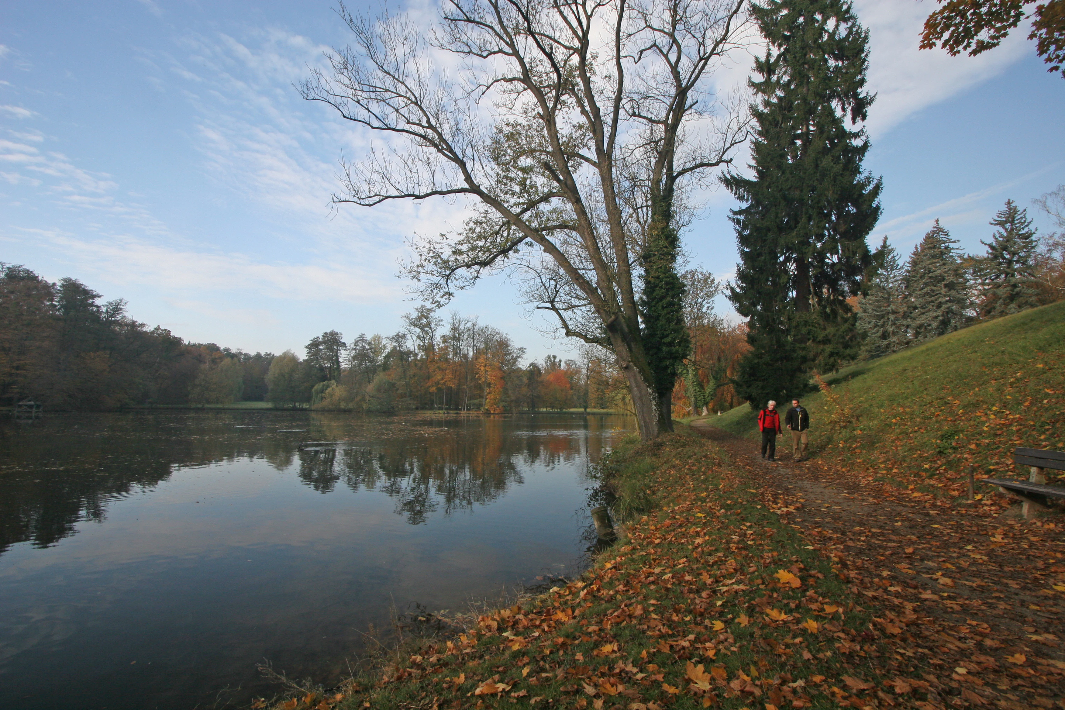
A calm, reflective pond in a park during autumn, with colorful fallen leaves covering the ground along the path where two people are walking.
A scenic view of the chateau park pond in autumn at Přírodní park Heřmanův Městec.

Přírodní park Heřmanův Městec history and protected-area timeline

The landscape that now forms Přírodní park Heřmanův Městec has been shaped over more than two centuries of aristocratic estate management. Following the reconstruction of the château in 1784, Count Jan Václav Špork established a natural-landscape-style English park on the grounds south of the building, taking advantage of the gentle rise of the terrain toward the south. This early park formed the core of what is still called the Zámecký park, and its design was completed by the second decade of the 19th century, when it received largely its present form.

The original layout relied on three diverging sight-lines cutting through the landscape. Of these, the central axis, roughly 600 metres long, has survived best and still links the château, the Zámecký rybník, and distant views toward Kunětická hora. The eastern portion of the park gradually evolved into a more naturalistic woodland of oak with an admixture of Scots pine, blending formal design with regenerated forest.

In the 20th century, the lesopark Palác, the largest section of today's protected area, received a major renewal of its trees and grassland in 1969, carried out in cooperation with Laub, the gardener of the last aristocratic owner from the Kinský family. A violent storm in June 2008 caused significant damage, requiring the felling of many trees. During the Second World War, part of the château park area was used as a military airfield, a transient chapter in its long history.

In 1996 the area was formally declared a nature park (přírodní park), providing legal protection to the landscape mosaic that had formed through centuries of estate care. Independently, the Zámecký park and Bažantnice were also recognised as the Heřmanův Městec natural monument and designated a European Site of Community Importance within the Natura 2000 network, reflecting both their heritage and their ecological value.

Přírodní park Heřmanův Městec landscape and geographic character

The landscape of Přírodní park Heřmanův Městec is defined by the meeting of two contrasting landform regions. The northern portion belongs to the Svitavská pahorkatina, more specifically the Heřmanoměstecká tabule, with gently rolling terrain. The southern portion climbs into the northern foothills of the Železné hory, and this juxtaposition produces a relatively pronounced elevation range within the park.

Near the Zámecký rybník pond in the northwest, the terrain sits at roughly 280 to 290 metres above sea level, while the wooded heights within the lesopark Palác rise to about 382 and 390 metres, giving the park a vertical span of more than 100 metres. This shift from water-side flats to forested ridges creates a layered visual experience, alternating open parkland views, meadow-edged slopes, and dense woodland crests.

Underlying this topography is a geological base of Upper Cretaceous sediments, predominantly calcium-rich marls. This calcareous substrate has shaped both the soil conditions and the vegetation communities, and explains the presence of calcium-demanding woodland and herb species throughout the area. Streams, including the Podolský potok and one of its right-bank tributaries, cut through the park, feeding the Zámecký rybník, the smaller Ježkovka pond, and the maintained spring known as Studánka U zlomené vrby.

Přírodní park Heřmanův Městec ecosystems, habitats, and plant life

The vegetation of Přírodní park Heřmanův Městec is largely secondary in character and reflects centuries of human design and management rather than undisturbed natural forest. The Zámecký park contains a curated arboretum of approximately 29 tree species, a mixture of native Central European broadleaves such as European beech, pedunculate oak, sessile oak, hornbeam, small-leaved and large-leaved lime, ash, and several maples, alongside introduced and ornamental species including black pine, Weymouth pine, Douglas fir, red oak, Caucasian walnut, Plane tree, catalpa, common horse chestnut, and weeping forms of beech.

The eastern part of the Zámecký park has, over time, taken on the character of a near-natural oak woodland with Scots pine admixture, illustrating how even formal parks can evolve into ecologically richer forest. The lesopark Palác continues this forested character on a larger scale and includes orchard enclosures within its mosaic.

The herb layer is particularly rich and supports a notable spring flora on the calcareous soils. Recorded species include wood anemone, yellow wood anemone, oxlip, dark lungwort, hairy buttercup, lily of the valley, herb Paris, hollowroot, spring pea, and toothwort, among others. Autumn crocus has also been observed flowering in late summer, adding a further seasonal dimension to the park's botanical interest.

Přírodní park Heřmanův Městec wildlife and species highlights

The wildlife profile of Přírodní park Heřmanův Městec combines typical Central European park and forest fauna with several species of genuine conservation importance. In the ground layer and among low vegetation, common reptiles and amphibians such as the smooth newt (skokan zelený), slow worm (slepýš křehký), and common lizard (ještěrka obecná) are present.

The park supports a varied woodland bird community that nests in its mature trees, including black woodpecker, great spotted woodpecker, Eurasian nuthatch, common chaffinch, several leaf warbler species (budníčci), and typical warblers (pěnice). Small mammals such as the wood mouse and the red-backed vole are common in the leaf-litter and soil layer.

Particular ecological significance is attached to the park's underground and built environments. The château cellars and attics host summer colonies of the critically endangered lesser horseshoe bat (vrápenec malý), while larger bat species including the greater mouse-eared bat, common pipistrelle, Daubenton's bat, and long-eared bat overwinter in the underground spaces of the park.

The single most important species driving the park's higher-level conservation status is the beetle páchník hnědý, a saproxylic insect dependent on old hollow trees. It is the documented presence of this species that led to the Zámecký park and Bažantnice being designated as a European Site of Community Importance under Natura 2000 and protected simultaneously as the Heřmanův Městec natural monument.

Přírodní park Heřmanův Městec conservation status and protection priorities

Přírodní park Heřmanův Městec carries multiple, overlapping layers of conservation recognition, reflecting the seriousness with which its habitats and species are treated. As a přírodní park, it benefits from landscape-level protection designed to preserve the overall character of the area, including its mix of designed parkland, forest, and agricultural edge zones, while still allowing recreational use by the local population.

On top of this, the Zámecký park and Bažantnice are separately declared as the Heřmanův Městec natural monument and designated as a Site of Community Importance under the European Natura 2000 network. This Natura 2000 designation was specifically triggered by the presence of the beetle páchník hnědý, an indicator of old trees and undisturbed deadwood habitats whose conservation has consequences for whole assemblages of saproxylic insects.

The underground and built parts of the château complex contribute a second important conservation thread through their bat fauna, including summer colonies of the critically endangered lesser horseshoe bat. Together, these designations make the park a small but ecologically dense conservation unit, where landscape heritage, old-growth habitat qualities, protected invertebrates, and underground bat roosts all interact within a single boundary.

Přírodní park Heřmanův Městec cultural meaning and human context

The cultural dimension of Přírodní park Heřmanův Městec is inseparable from its physical landscape. The park grew out of the aristocratic estate of Heřmanův Městec, and its present appearance owes much to Count Jan Václav Špork, who in 1784, in connection with the reconstruction of the château, laid out an English-style landscape park to the south of the building. This 18th-century landscape garden tradition, refined in the early 19th century, remains the cultural backbone of the area.

The Kinský family, the last aristocratic owners of the estate, left their own imprint, especially through the renewal of the lesopark Palác in 1969 by their gardener Laub. The presence of mature specimen trees, labelled for visitors, and the preserved sight-lines toward the château and Kunětická hora reflect a deliberate cultural tradition of framing views and presenting landscape as an aesthetic experience.

Even the Second World War left a trace: part of the park was temporarily converted into a military airfield. Today, the park holds a less dramatic but no less significant role as a shared local landscape, used by residents for short recreational visits and crossed by two marked hiking trails that link it to the broader Železné hory hiking tradition.

Top sights and standout views in Přírodní park Heřmanův Městec

A heritage-designed 18th-century landscape park wrapped around a late-Baroque château, with a still-intact 600-metre central vista linking the château, pond, and distant castle hill.

A 341-hectare protected area that fuses ornamental arboretum, near-natural oak wood, and older pasture-forest at Bažantnice, all set between two distinct landform regions.

A conservation story that reaches beyond the park itself: the same grounds host Natura 2000 habitats for the old-tree beetle páchník hnědý and summer colonies of the critically endangered lesser horseshoe bat in the château cellars.

Best time to visit Přírodní park Heřmanův Městec

Spring is one of the most rewarding periods to experience Přírodní park Heřmanův Městec, when the calcareous woodland floor comes alive with wood anemones, yellow anemones, lungwort, lily of the valley, and other spring geophytes, and the château park's arboretum displays fresh foliage. The reopening of the network of trails from Heřmanův Městec into the Železné hory also makes this season attractive for hikers.

Late summer and early autumn bring a different atmosphere, when light becomes warmer and lowland meadows and forest edges change colour; the autumn crocus has been recorded flowering in the park in late summer, providing an unexpected seasonal accent. Winter, with bare deciduous trees, emphasises the structure of the original 18th-century design, exposing the surviving sight-lines and the silhouette of the château more clearly than at any other time of year. Throughout the year, the park's role as a short-stay recreation area for the town makes it accessible at virtually any season.


Monthly climate preview

Long-term temperature ranges and monthly precipitation averages for Chrudim District

Přírodní park Heřmanův Městec Climate Normals and Annual Weather Patterns

Representative coordinate measurements reveal annual temperature swings alongside moderate monthly precipitation rates across the landscape. Examining the full twelve-month profile provides complete historical averages for detailed climate comparison.
Annual mean8 °C
-3 °C20 °C
Jan-3°
Feb-1°
Mar
Apr
May13°
Jun17°
Jul20°
Aug19°
Sep14°
Oct
Nov
Dec-1°
Warmest month
July

19.6 °C

Coolest month
January

-2.8 °C

Wettest month
July

2.8 mm/day

Driest month
April

1.2 mm/day

Park location guide

Geography guide, regional context, and park location map for Přírodní park Heřmanův Městec

Přírodní park Heřmanův Městec park geography, regions, and map view in Czechia

Understand where Přírodní park Heřmanův Městec sits in Czechia through a broader geographic reading of the surrounding landscape, nearby location context, and its mapped position within the national park landscape.

How Přírodní park Heřmanův Městec fits into Czechia

Czech Republic is a landlocked Central European country with a population of approximately 10.9 million people. The nation was established as an independent state on January 1, 1993, following the dissolution of Czechoslovakia. Its capital and largest city is Prague, with other major urban centers including Brno, Ostrava, Plzeň, and Liberec.

Wider geography shaping Přírodní park Heřmanův Městec in Czechia

The Czech Republic is a landlocked country in Central Europe. It is bordered by Germany to the west, Austria to the south, Poland to the northeast, and Slovakia to the southeast. The landscape is predominantly hilly, with the territory covering 78,871 square kilometers.

Map view of Přírodní park Heřmanův Městec

Use this park location map to pinpoint Přírodní park Heřmanův Městec in Czechia, understand its exact geographic position, and read its mapped placement within the surrounding landscape more clearly.

Pigeon | © OpenStreetMap contributors

Location context for Přírodní park Heřmanův Městec

Chrudim District

Visual exploration of historic château grounds, foothill forests, and protected habitats

Přírodní park Heřmanův Městec Photos and Landscape Scenery

Visual records capture the varied terrain and protected habitats across Přírodní park Heřmanův Městec. Photographic documentation reveals the interplay between aristocratic landscape design and natural foothill woodland zones.

A calm, reflective pond in a park during autumn, with colorful fallen leaves covering the ground along the path where two people are walking.

A group of light purple autumn crocus flowers growing in a grassy meadow.

Park atlas

Compare surrounding foothill forests, upland terrain, and protected natural areas.

Parks Near Přírodní Park Heřmanův Městec And Connected Regional Protected Landscapes

Browse other parks near Přírodní park Heřmanův Městec to examine similar regional landform transitions, calcium-rich woodland zones, and historic landscape designs. Comparing adjacent protected areas provides a wider geographical perspective on the upland terrain and valley stream corridors shaping the district.
A soft watercolor illustration of a winding stream flowing through green meadows and trees with distant low hills in the background.
Natural monumentPardubice Region
About 9 km away#1 closest

North

Meandry Struhy Natural Monument: A Case Study in Elbe Lowland Stream Geography

Riparian forests and winding stream channels in Pardubice Region.

Meandry Struhy stands as a significant natural monument in the Pardubice Region, protecting the unique geomorphology of a freely meandering stream. The area provides a rare look at undisturbed riparian galleries, floodplain forests, and vital nesting habitats for lowland bird species. This protected landscape offers a clear view into the ecological processes of the Elbe lowlands, where natural watercourse behavior continues to shape the local environment.

Area
0.402 km²
Established
1980
IUCN
IV
Relief
Lowland
A soft watercolor painting of a river landscape with rolling hills, grassy riverbanks, and light green vegetation under a pale sky.
Protected landscapePardubický kraj
About 12 km away#2 closest

Southwest

Přírodní park Doubrava Protected Landscape and River Valley Geography

A detailed map-based overview of the Doubrava River protected corridor in the Czech Republic.

Navigate the linear terrain of Přírodní park Doubrava, where natural riverine habitats meet industrial heritage in the Pardubický kraj. The area features a significant water tunnel, rocky banks, and a historic quarry-stone dam, creating an ecologically rich corridor that bridges the gap between the Bohemian-Moravian Highlands and the Iron Mountains.

Area
0.65 km²
Established
1998
Relief
Upland
Climate
Temperate
A soft watercolor painting showing a quiet pond landscape with grassy banks, reeds, and distant trees against a pale background.
Nature reservePardubický kraj
About 26 km away#3 closest

Southeast

Ratajské rybníky Protected Nature Reserve: Highland Wetland Geography and Mapped Boundaries

A core wetland refuge for rare flora and fauna in the Pardubický kraj region

The Ratajské rybníky reserve represents a vital highland wetland ecosystem characterized by its three connected fishponds and surrounding quaking bogs. This mapped protected area provides an essential habitat for endangered butterfly populations, the rare moss Hamatocaulis vernicosus, and dense amphibian breeding grounds, set against the backdrop of the forested Železné hory mountain ridge.

Established
1990
IUCN
IV
Relief
Upland
Climate
Temperate
Watercolor painting of a peaceful wetland landscape with a winding stream, soft rolling hills in the background, and wild meadow vegetation in the foreground.
Natural monumentKrálovéhradecký kraj
About 28 km away#4 closest

Northeast

Roudnička a Datlík Natural Monument: Wetland Geography and Protected Landscape Context

A vital ecological refuge within the Královéhradecký landscape.

Roudnička a Datlík protects a rare wetland mosaic of fishponds, reedbeds, and purple moor-grass meadows on the edge of the East Bohemian table. This natural monument remains a key site for regional conservation management, supporting a variety of orchids and waterbirds within an urban-fringe environment. Explore the site's mapped boundaries and its role in protecting lowland biodiversity.

Area
0.297 km²
Established
1988
IUCN
IV
Relief
Lowland
Natural monumentKrálovéhradecký kraj
About 30 km away#5 closest

Northwest

Víno Natural Monument: Mapped Protected Landscapes and Geographic Overview

Protected oak and hornbeam forest in eastern Bohemia

Víno Natural Monument is a significant protected area within the Královéhradecký kraj region, focused on the conservation of century-old broadleaf woodland. This location preserves essential deadwood microhabitats and diverse plant species, offering a clear example of lowland forest ecology integrated into the cultivated landscape of eastern Bohemia.

Area
0.725 km²
Established
2013
IUCN
III
Relief
Lowland
Watercolor painting of a landscape featuring soft green hills, coniferous trees, and low-lying wetland vegetation in shades of pink and green.
Nature reserveKrálovéhradecký kraj
About 31 km away#6 closest

Northeast

Na Plachtě 3 Nature Reserve: Mapped Protected Landscapes in the Královéhradecký kraj

Explore the diverse sandy habitats and protected terrain of this Czech natural monument

Na Plachtě 3 represents a critical protected enclave in the Královéhradecký kraj, characterized by its mosaic of dry heaths, open sand patches, and peat meadows. This lowland site provides essential hibernation grounds for amphibians and invertebrates, maintaining a rich biological profile that contrasts with the urban-adjacent geography of Hradec Králové. Analyze its protected boundaries, geological history, and early successional landscape character through detailed mapping.

Area
0.17 km²
Established
2012
IUCN
IV
Relief
Lowland
A horizontal watercolor illustration depicting a soft, rolling landscape with clusters of green trees against a pale, light-colored background.
Nature reserveCzechia
About 31 km away#7 closest

Northeast

Na Plachtě Nature Reserve: Mapped Wetlands and Conservation Geography in Czechia

Urban-edge wetland mosaic with ponds and peat meadows

Located in eastern Bohemia, the Na Plachtě nature reserve encompasses a 39-hectare landscape of ponds, marshland, and sandy patches. This important Natura 2000 protected area offers a deep look into specialized amphibian and insect habitats, maintained through active management and community-led conservation efforts.

Area
0.388 km²
Established
2013
Scope
Terrestrial
Water
Major water bodies
A soft watercolor illustration featuring rolling hills in pink and green tones with stylized coniferous trees, set against a white background.
Natural monumentPardubický kraj
About 41 km away#8 closest

Southeast

Rybenské Perničky: Natural Monument and Geological Landmark of the Bohemian-Moravian Highlands

Geological rock outcrops and protected upland terrain in the Pardubice Region

Investigate the geological structure of Rybenské Perničky, a protected natural monument featuring unique orthogneiss outcrops and characteristic bowl-shaped weathering basins. Situated in the Pardubice Region, this site offers a focused look at the crystalline rock formations and undulating plateau terrain of the Bohemian-Moravian Highlands, providing essential geographic context for this noteworthy natural landmark.

Area
0.141 km²
Established
1980
Relief
Upland
Climate
Temperate

Common questions about visiting, size, designation, and location context for Přírodní park Heřmanův Městec

Přírodní park Heřmanův Městec FAQs for park facts, access, geography, and protected area context

Find quick answers about Přírodní park Heřmanův Městec, including protected-area facts, park geography, trail and visitor context, and how the park fits into its surrounding country and regional landscape.
MoriAtlas Explorer

Continue Your Protected Areas Search Across the Global Atlas

Deepen your exploration by continuing the structured search for national parks and protected areas worldwide. Utilize the comprehensive filtering capabilities to compare different conservation landscapes and refine your understanding of global park geography. Discover more about the distribution and characteristics of protected natural areas.

Global natural geography