

Mori Atlas logo
Protected landscapePřírodní park Hrádeček

A regional protected area defined by forested summits, hilltop ruins, and Bohemian hill-country terrain.

Přírodní park Hrádeček: Analyzing the Geography and Protected Landscapes of Trutnov District

Přírodní park Hrádeček serves as a significant protected landscape situated within the Trutnov District of the Czech Republic, where the foothills of the eastern Giant Mountains transition into the rolling Podkrkonoší countryside. This area is characterized by a distinctive bowl-like formation of forested ridges, including Vlčí skála, Pekelský vrch, Havran, and Skalka, which enclose a mix of meadows and rural land. Beyond its natural terrain, the park preserves the cultural silhouette of the Břecštejn castle ruin, providing a focal point within this intimate, historically grounded landscape.

Bohemian countrysideforested hillsprotected landscapecastle ruinhilltop ridgesgiant mountains foothills

Přírodní park Hrádeček

Protected landscape

Park overview

Structured park overview, official facts, and landscape profile for Hrádeček Nature Park

Hrádeček Nature Park park facts, protected area profile, and essential visitor context

Review the core facts for Hrádeček Nature Park, including designation, size, terrain, visitor scale, habitats, and operating context in one park-focused overview.

About Hrádeček Nature Park

Hrádeček Nature Park is a locally declared protected landscape area in the Trutnov District, lying just west of the town of Trutnov in northeastern Bohemia. It occupies a transitional countryside zone where the foothills of the Giant Mountains meet the rolling agricultural land of the Podkrkonoší region. The park sits between the village of Hertvíkovice to the north and the municipality of Vlčice to the south, giving it a clear position within an inhabited and traditionally farmed landscape.

The defining feature of the park is its ring of four forested hills, each named and each rising above 550 meters in elevation. Vlčí skála, at 587 meters, is the highest of the group, followed by Pekelský vrch at 583 meters, Havran at 564 meters, and Skalka at 550 meters. Together these summits enclose the protected core, producing an intimate landscape of slopes, valleys, small streams, and wooded ridges rather than sweeping panoramas.

At the cultural centre of this natural setting stands the ruin of Břecštejn, a small medieval hilltop castle. The presence of the ruin adds a historical dimension that complements the natural protection of the area and gives visitors a specific focal point for walks within the park. The landscape overall reflects a typical Bohemian protected-area model, where the goal is to maintain the rural and scenic character of well-populated countryside rather than to create a strictly regulated wilderness reserve.

Quick facts and research context for Hrádeček Nature Park

Hrádeček Nature Park was formally declared on 17 April 2000 by the District Office in Trutnov. It covers a hilly landscape west of Trutnov, between the settlements of Hertvíkovice and Vlčice, and lies within the Trutnov District of the Hradec Králové Region.

The terrain is shaped by four named ridges and summits surrounding the protected area, with elevations ranging roughly between 550 and 587 meters above sea level. The park is partly encircled by the first-class road I/14, and is accessible to walkers via the blue and green marked hiking trails. The ruin of the small castle Břecštejn is located within the park.

Protection and recognition

Documented terrestrial protection scope and established designation year

Přírodní park Hrádeček Protection Status and Designation History

Přírodní park Hrádeček holds a documented terrestrial protection status established in the year 2000. Structured conservation facts outline the official designation history and management scope without external recognition sources.

Protection details

Protection scope
Terrestrial
Designated year
2000
Transboundary protection
No
Park context

Deeper park guide and search-rich context for Hrádeček Nature Park

Hrádeček Nature Park history, landscape, wildlife, and travel context

Explore Hrádeček Nature Park through its history, landscape character, ecosystems, wildlife, conservation priorities, cultural context, and seasonal travel timing in a structured park guide built for atlas discovery and search intent.

Why Hrádeček Nature Park stands out

Hrádeček Nature Park is best known for its compact setting of forested hills surrounding a quiet countryside landscape west of Trutnov. The protected area wraps around a cluster of modest summits, including Vlčí skála, Pekelský vrch, Havran, and Skalka, giving visitors a sense of enclosure within wooded ridges rather than open vistas. The park is also recognised for the presence of Břecštejn castle ruin, a small hilltop fortification whose weathered remains contribute significantly to the area's cultural and scenic character. This combination of hill forest, traditional Bohemian rural land, and a medieval ruin is what gives the park its distinct identity compared with the larger, more heavily visited landscapes nearby.
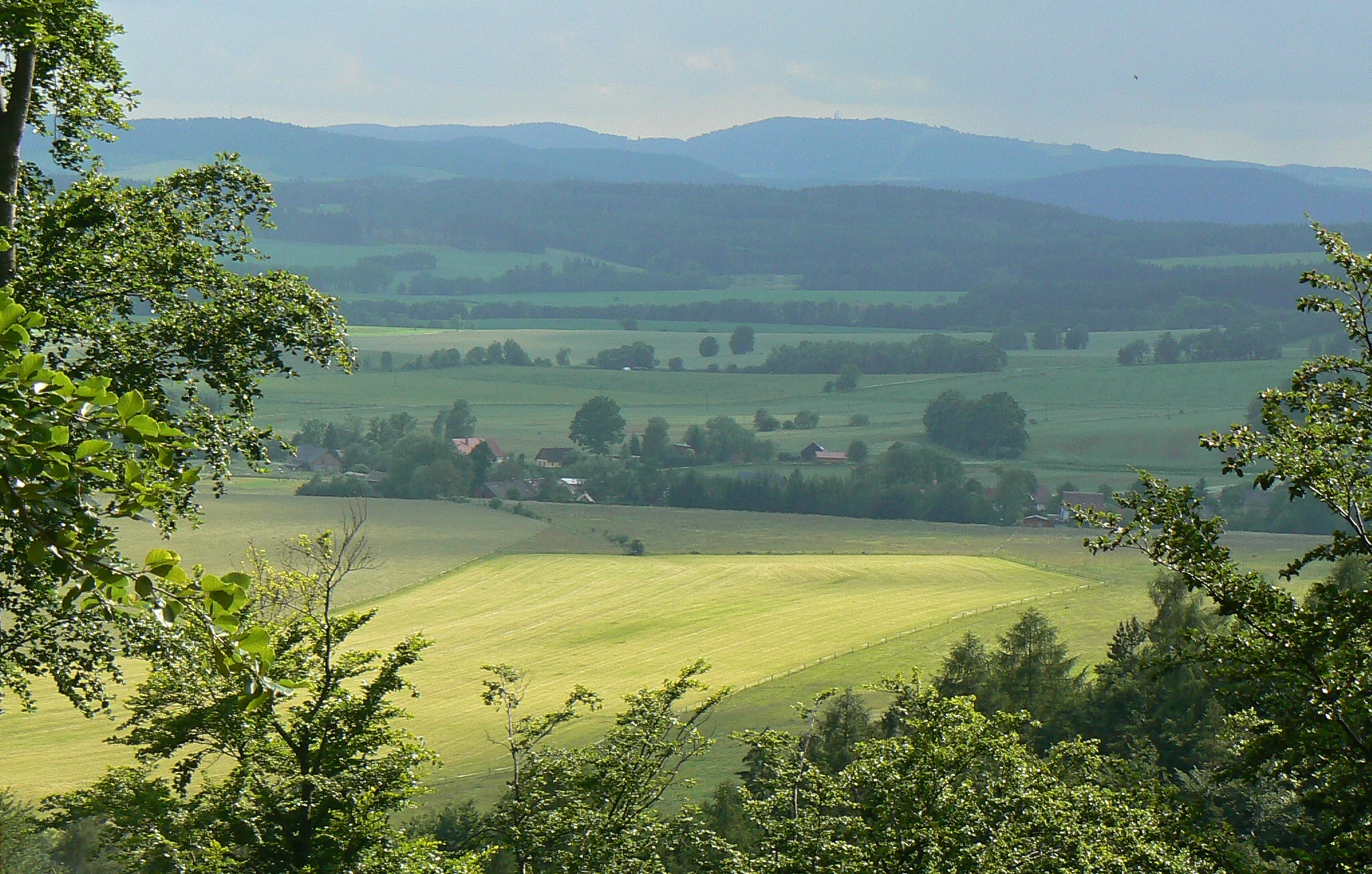
View from Brecstejn
View from the ruins of Brecstejn castle in Hradecek Nature Park, Trutnov District, Czech Republic

Hrádeček Nature Park history and protected-area timeline

Hrádeček Nature Park was formally established on 17 April 2000, when it was declared by the District Office in Trutnov. Like other Czech natural parks (přírodní parky), it was created to preserve the visual, ecological, and cultural character of a valued rural landscape rather than to enforce the stricter protections associated with national parks or nature reserves.

The area's deeper history is tied largely to the medieval structure of Břecštejn, the ruined hilltop castle within the park's boundaries. While specific details about the castle's construction and decline are not laid out in the source material, the ruin is recognised as a defining historical landmark of the protected area and has helped shape the park's identity as a place where natural and cultural heritage meet.

In more recent years, the area has also drawn public attention because of a development proposal. Around 2019, the actress Dagmar Havlová, widow of former Czechoslovak and Czech president Václav Havel, announced plans to build a hotel complex called Hrádeček Resort near the former presidential chalet in the settlement of Hrádeček. The proposal met with opposition from parts of the public and from relevant officials, reflecting ongoing tension around how development pressure should be handled in and around the park.

Hrádeček Nature Park landscape and geographic character

The landscape of Hrádeček Nature Park is shaped by a compact group of forested hills rather than by a single dramatic landform. The four named summits surrounding the protected area, Vlčí skála (587 m), Pekelský vrch (583 m), Havran (564 m), and Skalka (550 m), give the park a bowl-like character, with slopes and small valleys enclosed by wooded ridges. None of the summits rises dramatically above the surroundings, but together they create a recognisable sense of landscape enclosure.

The terrain reflects a transition between the eastern foothills of the Giant Mountains and the gentler agricultural countryside of the Podkrkonoší region. As a result, the protected area contains a mixture of forest patches, meadows, and farmed land, integrated into a single coherent landscape unit rather than separated into distinct zones of strict natural habitat.

The ruin of Břecštejn introduces a vertical cultural element into this natural setting, standing on a hilltop within the park and acting as a visible landmark from several vantage points within the protected area. The combined effect of ridges, small valleys, mixed land use, and the castle ruin gives the park a distinctive visual identity that is more about intimate Bohemian hill-country scenery than about dramatic or wilderness-style landscapes.

Hrádeček Nature Park conservation status and protection priorities

Hrádeček Nature Park was declared in 2000 under Czech natural park legislation, a category that protects valued countryside landscapes rather than ecologically critical habitats in the strictest sense. Its conservation role centres on maintaining the scenic and ecological balance of a populated rural area, where forest, meadows, and traditional land use coexist within a single protected boundary.

The park's location at the edge of the Giant Mountains foothills means it helps maintain a buffer zone between the more strictly protected alpine and subalpine landscapes further west and the agricultural lowlands to the east. In this sense, even though Hrádeček is not a high-stakes biodiversity reserve, it serves an important landscape-level function by preserving the character of an inhabited Bohemian countryside that would otherwise be vulnerable to piecemeal development.

Hrádeček Nature Park cultural meaning and human context

The most prominent cultural element within Hrádeček Nature Park is the ruin of Břecštejn, a small medieval castle whose weathered remains sit on a hilltop surrounded by the protective landscape framework. The ruin gives the park a tangible historical anchor and ties the natural protected area to the broader pattern of small hilltop fortifications found throughout the Czech countryside.

The settlement of Hrádeček itself, lying near the park, also carries modern cultural significance. The area became better known publicly through the former presidential chalet associated with Václav Havel, and around 2019 a proposed hotel development by Dagmar Havlová brought the location into national discussion about how cultural heritage sites, residential use, and protected landscapes should be balanced in the Czech Republic.

Top sights and standout views in Hrádeček Nature Park

Hrádeček Nature Park's most distinctive quality is the way its four named forested summits, Vlčí skála, Pekelský vrch, Havran, and Skalka, frame a contained countryside setting just west of Trutnov. Walking through the park, visitors move between slopes, small valleys, and wooded ridges rather than across open terrain, which gives the area a particular sense of enclosure and intimacy unusual for a small protected landscape.

Equally important is the ruin of Břecštejn, which provides the park with a cultural-scenic focal point and reinforces its identity as a place where Bohemian hill-country scenery and medieval heritage reinforce one another. The combination of modest elevation, mixed land use, easy hiking access along the blue and green marked trails, and the historical presence of the castle ruin gives Hrádeček a character that distinguishes it from larger, wilder protected landscapes nearby.

Best time to visit Hrádeček Nature Park

As a small Bohemian countryside landscape with elevations between roughly 550 and 587 meters, Hrádeček Nature Park is best experienced during the warmer months, when forest trails and meadow edges are approachable and the surrounding ridges are visually appealing. Late spring and summer tend to bring out the green character of the forested slopes, while autumn typically colours the hill forests around Vlčí skála, Pekelský vrch, Havran, and Skalka.

Winter conditions in the park are not a primary reason for visiting based on available information, and the surrounding road network, including the I/14 corridor, suggests the park is more naturally used as a walking and scenery destination in the milder seasons. Visitors interested in the Břecštejn ruin will find that clear-weather days offer the best contrast between stone, forest, and surrounding hill silhouettes.


Monthly climate preview

Long-term representative point measurements for temperature and precipitation

Přírodní park Hrádeček Climate Normals and Annual Temperature Rhythm

Representative coordinate records show measured monthly temperature and precipitation variation across the terrain of Přírodní park Hrádeček from 1991 to 2020. Examining the complete twelve-month climate profile reveals detailed long-term averages for every month of the year.
Annual mean7 °C
-4 °C18 °C
Jan-4°
Feb-2°
Mar
Apr
May12°
Jun16°
Jul18°
Aug18°
Sep13°
Oct
Nov
Dec-2°
Warmest month
July

18.1 °C

Coolest month
January

-3.7 °C

Wettest month
July

3.1 mm/day

Driest month
April

1.4 mm/day

Park location guide

Geography guide, regional context, and park location map for Hrádeček Nature Park

Hrádeček Nature Park park geography, regions, and map view in Czechia

Understand where Hrádeček Nature Park sits in Czechia through a broader geographic reading of the surrounding landscape, nearby location context, and its mapped position within the national park landscape.

How Hrádeček Nature Park fits into Czechia

Czech Republic is a landlocked Central European country with a population of approximately 10.9 million people. The nation was established as an independent state on January 1, 1993, following the dissolution of Czechoslovakia. Its capital and largest city is Prague, with other major urban centers including Brno, Ostrava, Plzeň, and Liberec.

Wider geography shaping Hrádeček Nature Park in Czechia

The Czech Republic is a landlocked country in Central Europe. It is bordered by Germany to the west, Austria to the south, Poland to the northeast, and Slovakia to the southeast. The landscape is predominantly hilly, with the territory covering 78,871 square kilometers.

Map view of Hrádeček Nature Park

Use this park location map to pinpoint Hrádeček Nature Park in Czechia, understand its exact geographic position, and read its mapped placement within the surrounding landscape more clearly.

Pigeon | © OpenStreetMap contributors

Location context for Hrádeček Nature Park

Trutnov District

Visual reference of forested hills, medieval ruins, and protected terrain.

Přírodní park Hrádeček Photos and Landscape Scenery Exploration

Photographic records reveal the forested ridges, sloping valleys, and intimate countryside character that define the protected landscape. Examining these visual elements helps interpreters understand the terrain, habitat mix, and cultural landmarks spread across the hills.

View from Brecstejn

Park atlas

Compare regional forested hills, hilltop ruins, and neighboring Bohemian foothill reserves

Exploring Other Parks Near Přírodní park Hrádeček and Surrounding Protected Landscapes

Browsing adjacent protected areas reveals how regional hill country transitions into broader forest reserves across the surrounding landscape. Comparing nearby parks provides deeper context on contiguous terrain, local elevations, and neighboring conservation zones.
Watercolor painting showing green forests, a valley, and distant mountains under a soft sky
National parkLiberec Region
About 1.4 km away#1 closest

North

Krkonoše National Park: Central European Alpine Protected Area and Map Context

Discover glacial landforms and unique ecosystems in the Giant Mountains.

Krkonoše National Park, situated in the Liberec Region, is a premier example of a protected alpine landscape in Central Europe. This page facilitates exploration of its significant glacial geography, including distinct cirques, rockfields, and valleys, providing vital context for understanding its protected area status. Engage with the mapped terrain and discover the unique ecological features that make this national park a cornerstone of conservation and geographic study within the Czech Republic.

Area
363.52 km²
Established
1963
IUCN
II
Visitors
12.1M annual
Natural monumentKrálovéhradecký kraj
About 5.7 km away#2 closest

North

Sklenářovické údolí Natural Monument: Geography, Terrain, and Protected Land Features

Meadow-rich valley ecosystems in the Krkonoše foothills

Sklenářovické údolí stands as a significant protected natural monument in the Královéhradecký kraj region. Its geography consists of a deeply carved stream valley that shelters an unusually high concentration of rare orchid species and sensitive wetland habitats. The area provides a clear look at historical land-use restoration, where meadow and forest boundaries are maintained to protect diverse raptor nesting grounds and fragile montane flora within the broader Czech landscape network.

Area
1.806 km²
Established
2009
IUCN
III
Relief
Mountain
Watercolor illustration of a mountain range with green hills, pink and yellow sky, and sparse vegetation
National parkPoland
About 10 km away#3 closest

Northwest

Karkonosze National Park: A Premier National Park in Poland's Giant Mountains

Discover alpine terrain and unique glacial landscapes.

Karkonosze National Park is a significant protected area in Poland, renowned for its dramatic alpine topography carved by ancient glaciers. As the highest range in the Polish Sudetes, it features striking U-shaped valleys, U-shaped glacial cirques, and diverse subalpine to alpine ecosystems. This national park provides a rich context for understanding Central European mountain geography and exploring its mapped protected boundaries.

IUCN
II
Relief
Mountain
Scope
Terrestrial
Natural monumentKrálovéhradecký kraj
About 16 km away#4 closest

West

Vejsplachy Natural Monument: Protected Floodplain Forest and Wetland Geography in Czech Republic

Ecological mosaic and regional floodplain habitat in Královéhradecký kraj

Vejsplachy serves as a significant natural monument, preserving a rare convergence of ash and alder floodplain forest, wet thistle meadows, and aquatic reedbeds. Located on the edge of the town of Vrchlabí, this 3.34 hectare protected area offers a deep look into the geomorphology of the Královéhradecký kraj foothills and the delicate balance of surviving wetland habitats in a changing landscape.

Area
0.033 km²
Established
2020
IUCN
IV
Relief
Upland
National parkDolnośląskie Voivodeship
About 18 km away#5 closest

Northwest

Karkonoski Park Narodowy: Mapping Protected Granite Peaks and Glacial Terrain in Poland

High-mountain landscapes in the Dolnośląskie Voivodeship

Trace the diverse geography of Karkonoski Park Narodowy, where granite blockfields and glacial cirques define the high-altitude terrain. This protected area represents one of Central Europe's most significant upland ecosystems, showcasing a vertical transition from dense forest to alpine tundra.

Area
59.51 km²
Established
1959
Visitors
2M annual
Relief
Mountain
Protected landscapeLower Silesian Voivodeship
About 28 km away#6 closest

East

Park Krajobrazowy Sudetów Wałbrzyskich: Protected Mountain Landscape Map

Geographic overview of forested ridges and rock formations

Gain insight into the topography of Park Krajobrazowy Sudetów Wałbrzyskich, where elevations reach 936 meters. This atlas entry details the forested Central Sudetes landscape, highlighting protected geological monuments like Małpia Skała and the unique hydrology of the Rybna river capture.

Area
64.93 km²
Established
1998
Relief
Mountain
Climate
Temperate
Natural monumentKrálovéhradecký kraj
About 28 km away#7 closest

South

Vražba Natural Monument: Botanical Geography and Protected Lands in Královéhradecký Kraj

A rare habitat for critically endangered Central European flora.

Vražba is a specialized protected area located in the Královéhradecký region, designated primarily to stabilize populations of the critically endangered ladybells. Its landscape consists of managed woodland edges and semi-open grassland patches, creating a highly specific environment for rare botanical communities. This site stands as a prime example of targeted habitat management within the broader Czech protected-area network.

Area
0.078 km²
Established
2011
IUCN
III
Protected areaLower Silesian Voivodeship
About 33 km away#8 closest

North

Trzcińskie Mokradła Protected Area: Geographic Overview and Mapped Sudeten Wetland Landscape

Located in the Lower Silesian Voivodeship of Poland

Trzcińskie Mokradła stands as a significant mire complex in the Jelenia Góra Basin, providing a rare look at peat-forming habitats in the Sudetes. This protected area offers deep insight into regional wetland conservation and the environmental history of southwestern Poland, serving as an essential reference for researchers and landscape enthusiasts interested in intramontane basin geography.

Area
0.753 km²
Established
2011
Scope
Terrestrial
Water
Major water bodies

Common questions about visiting, size, designation, and location context for Hrádeček Nature Park

Hrádeček Nature Park FAQs for park facts, access, geography, and protected area context

Find quick answers about Hrádeček Nature Park, including protected-area facts, park geography, trail and visitor context, and how the park fits into its surrounding country and regional landscape.
MoriAtlas Explorer

Continue Your Protected Areas Search Across the Global Atlas

Deepen your exploration by continuing the structured search for national parks and protected areas worldwide. Utilize the comprehensive filtering capabilities to compare different conservation landscapes and refine your understanding of global park geography. Discover more about the distribution and characteristics of protected natural areas.

Global natural geography

