
Mori Atlas logo
Nature reservePtačí stěna

Analyzing the granulite cliffs, boulder scree slopes, and mature beech forest geography.

Ptačí stěna Nature Reserve: A Detailed Geographic Atlas of South Bohemian Protected Landscapes

(Přírodní rezervace Ptačí stěna)

Ptačí stěna Nature Reserve represents a focused, geologically significant protected area situated within the forested Blanský les of the Český Krumlov District. This site features an 800-meter-long granulite frost-riven cliff towering above an extensive talus apron of large boulder fields. The reserve provides a compact, protected environment where old-growth beech stands intermix with complex rock-talus microhabitats and submontane forest terrain.

nature reservebeech forestsubmontane forestrock cliffgranulite cliffboulder talus
A flat-style digital illustration showing a tall, thin waterfall cascading down a sheer mountain cliff into a river, surrounded by pine forests and large boulders in the foreground.

Ptačí stěna

Nature reserve

Park overview

Structured park overview, official facts, and landscape profile for Ptačí stěna

Ptačí stěna park facts, protected area profile, and essential visitor context

Review the core facts for Ptačí stěna, including designation, size, terrain, visitor scale, habitats, and operating context in one park-focused overview.

About Ptačí stěna

Ptačí stěna is a focused nature reserve within the broader Blanský les Protected Landscape Area, a wooded region of South Bohemia that has long been recognized for its forest biodiversity. The reserve is small in extent but rich in character, centered on a single dramatic hillside rather than a wide mosaic of habitats. Its identity is shaped by the interaction between geology and forest: a long rocky cliff crowning the slope and a deep apron of large boulders below, both embedded in a mature beech-dominated forest.

Administratively, Ptačí stěna lies in the Český Krumlov District of the South Bohemian Region, with the village of Janské Údolí nearby and Brloh roughly four kilometers to the northeast. It was established as a nature reserve on 1 November 1996 by the administration of the Blanský les Protected Landscape Area, confirming its significance within that larger system. The site falls under IUCN management category IV, reflecting its role in protecting a particular habitat and species assemblage rather than a broad landscape.

Ecologically, the reserve's defining combination of steep terrain, rocky substrate, and old broadleaf forest makes it a notable refuge within the Blanský les. The protection of the old-growth trees, the cliff and boulder habitats, and the associated understory flora and fauna reflects a deliberate effort to safeguard an unusually intact piece of southern Bohemian forest landscape.

Quick facts and research context for Ptačí stěna

Ptačí stěna is a Czech nature reserve (přírodní rezervace) lying within the Blanský les Protected Landscape Area in the Český Krumlov District of the South Bohemian Region. It sits on the southwestern slope of Bulový, roughly four kilometers southwest of Brloh. Established on 1 November 1996, the reserve covers about 20.53 hectares at elevations between roughly 740 and 870 meters above sea level and is administered under the framework of the Blanský les PLA. Its protected subject is a steep, boulder-strewn slope combining mature submontane and montane beech forest with an outstanding granulite frost-riven cliff and talus system.

Protection and recognition

Documented protection scope and official designation records for Ptačí stěna

Ptačí Stěna Protection Status and Terrestrial Conservation Data

Comprehensive conservation metrics outline the terrestrial protection status and management framework established for Ptačí stěna. Verified designation records provide structured insight into the environmental scope governing this protected natural landscape.

Protection details

Protection scope
Terrestrial
Transboundary protection
No
Park context

Deeper park guide and search-rich context for Ptačí stěna

Ptačí stěna history, landscape, wildlife, and travel context

Explore Ptačí stěna through its history, landscape character, ecosystems, wildlife, conservation priorities, cultural context, and seasonal travel timing in a structured park guide built for atlas discovery and search intent.

Why Ptačí stěna stands out

Ptačí stěna is best known for the long granulite frost-riven cliff that crowns its upper slope and the extensive boulder talus that fans out beneath it. The reserve is recognized as one of the more striking examples in the Blanský les of a steep, old-growth beech forest combined with a major rocky landform. The cliffs and the humid scree at their base shape the ecological character of the site, supporting old beech stands of up to about 150 years of age, a rich understory of typical submontane woodland herbs, and cool, sheltered microhabitats where moisture-loving species such as the alpine shrew have been documented. Visitors value Ptačí stěna as much for its rugged geology and forest atmosphere as for any single species or viewpoint.
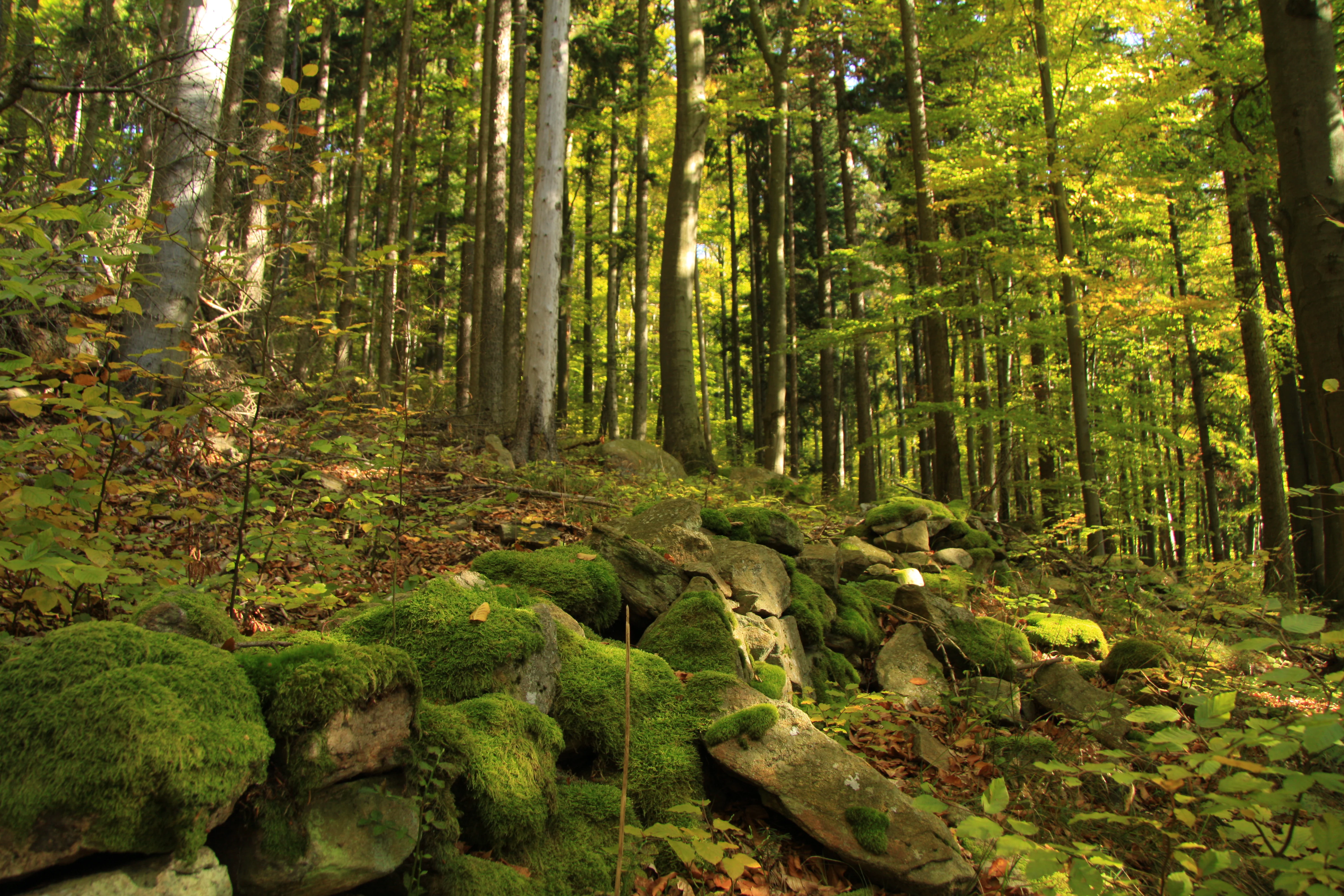
A forest scene in autumn featuring tall trees and a foreground of large boulders heavily covered in green moss.
Autumn foliage and mossy boulders in the Ptačí stěna nature reserve.

Ptačí stěna history and protected-area timeline

Ptačí stěna was formally designated as a nature reserve (přírodní rezervace) on 1 November 1996, with the establishment proclaimed by the administration of the Blanský les Protected Landscape Area. Its creation reflected growing recognition within the Czech conservation system that particular slopes and rock formations within larger protected landscapes deserve their own focused protection, even when the surrounding forest is already part of a broader landscape-level reserve.

The reserve's protected subject, centered on submontane and montane beech forest with a significant admixture of wych elm growing on a steep, boulder-strewn slope, was considered important enough to warrant a separate designation rather than relying solely on the umbrella framework of the Blanský les Protected Landscape Area. The establishment recognized both the value of the oldest beech stands, some of which are around 150 years old, and the special significance of the long granulite frost-riven cliff and the large boulder talus below it.

Ptačí stěna landscape and geographic character

The landscape of Ptačí stěna is defined by a single steep southwestern slope of Bulový, dropping through a vertical band of bare rock into a sloping apron of broken stone. At the top of the reserve, an extensive frost-riven (mrazový srub) cliff carved from granulite runs along the slope for roughly 800 meters and rises to about 15 meters, forming one of the more conspicuous rocky ledges anywhere within the Blanský les.

Below the cliff, the terrain transitions into a thick talus field that extends outward from the rock face for about 100 meters. This apron is dominated by very large blocks, with some boulders reaching about 3 meters across, creating a chaotic, deeply creviced surface that contrasts sharply with the smoother forested slopes elsewhere in the protected landscape area. The interplay between the linear cliff above and the expansive boulder field below gives Ptačí stěna a clearly geological identity, unusual within the predominantly forested character of the surrounding Blanský les.

Ptačí stěna ecosystems, habitats, and plant life

The reserve protects a coherent block of submontane and montane beech forest situated on a steep, blocky slope. The canopy is dominated by European beech (Fagus sylvatica), with a meaningful admixture of wych elm (Ulmus glabra) that adds structural diversity to the stand. The oldest trees in the reserve are around 150 years old, giving parts of the forest a genuinely old-growth character and supporting the type of microhabitats that distinguish mature Bohemian woodlands from younger, more uniform stands.

The herb layer is rich and characteristic of well-developed Central European beech forests on calcareous-leaning substrates, with wood fescue as a dominant grass and companions such as Prenanthes purpurea, Actaea spicata, Galium odoratum, Senecio ovatus, Viola reichenbachiana, Milium effusum, Dentaria enneaphyllos, Mercurialis perennis and Symphytum tuberosum. Among the shrubs, Daphne mezereum is a typical feature. The rocky setting adds further ecological value: the cliff and the shaded boulder talus create persistently humid, sheltered microclimates that support moisture-loving species and contribute to the reserve's broader biodiversity within the Blanský les Protected Landscape Area.

Ptačí stěna wildlife and species highlights

The protected fauna of Ptačí stěna is closely tied to the structure of the reserve rather than to any single charismatic species. The mature beech stands, the shaded boulder talus and the persistent humidity of the cliff base together create habitat for typical forest-floor fauna, including ground-dwelling invertebrates and small mammals associated with old broadleaf woodland.

Of particular conservation note is the documented presence of the alpine shrew (Sorex alpinus) in the moist scree and boulder pockets of the reserve. This relict species, normally associated with montane and submontane conditions, depends on exactly the kind of cool, humid, structurally complex habitat that the cliffs and boulder field at Ptačí stěna provide, and its presence underlines the importance of the reserve's rock-talus landforms for regional biodiversity.

Ptačí stěna conservation status and protection priorities

Ptačí stěna is significant from a conservation perspective because it protects a tightly defined combination of habitats that would be vulnerable to forestry or rock-quarrying pressure if left outside the protected-area system. The old-growth beech and elm stands represent a relatively mature forest state that is increasingly rare in intensively managed Central European forests, while the granulite cliff and boulder talus are essentially irreplaceable on human timescales once disturbed.

The reserve's classification under IUCN Category IV (habitat/species management area) reflects this focus on safeguarding a particular habitat and species assemblage rather than managing a broader landscape. By embedding Ptačí stěna within the larger Blanský les Protected Landscape Area, Czech conservation policy links site-level protection of forest, cliff and talus habitats to a wider strategy of preserving the character of the Blanský les as a whole, giving the small reserve a broader landscape-scale conservation role.

Top sights and standout views in Ptačí stěna

Ptačí stěna stands out within the Blanský les for the unusual pairing of a long, exposed granulite frost-riven cliff with an exceptionally large boulder talus, both set within mature submontane beech forest. The 800-meter-long cliff and its 100-meter-wide apron of blocks reaching roughly three meters across create a distinctly rugged character unusual in the otherwise smoothly forested landscape of the protected area.

The reserve also offers a strong example of layered habitat protection: old trees of up to about 150 years, a rich submontane woodland flora, and a relict mammal in the alpine shrew, all sustained by a single steep hillside. For visitors and ecological audiences alike, Ptačí stěna is a compact showcase of how rock and forest combine to produce unusually intact habitat in South Bohemia.

Best time to visit Ptačí stěna

The character of Ptačí stěna changes meaningfully with the seasons, even though the reserve is small and sheltered by forest for much of the day. Spring and early summer are the most rewarding periods botanically, when the herb layer of wood fescue and accompanying species such as Prenanthes purpurea, Actaea spicata and Mercurialis perennis is fully developed beneath the fresh beech canopy.

Autumn brings its own appeal. As the source photographs of the reserve suggest, the beech forest turns color over the boulder field, and the cliff and talus read clearly through the thinning foliage, making the geology of the site especially visible. Snow cover in winter can likewise reveal the structure of the cliff and the boulder apron, though conditions on the steep slope can be challenging. Throughout the year, the in-forest atmosphere is the main draw, so any visit with comfortable weather and reasonable daylight is likely to be rewarding.

Monthly climate preview

Long-term representative point data tracking monthly temperature ranges and precipitation

Ptačí stěna Climate Normals: Measured Temperature and Precipitation Rhythms

Historical measurements from 1991 to 2000 trace the recurring annual rhythm of average temperatures and precipitation across Ptačí stěna. Examining the full monthly climate profile reveals detailed thermal ranges and moisture patterns for this protected terrain.
Annual mean8 °C
-3 °C19 °C
Jan-3°
Feb-1°
Mar
Apr
May13°
Jun17°
Jul19°
Aug19°
Sep13°
Oct
Nov
Dec-2°
Warmest month
July

18.8 °C

Coolest month
January

-2.8 °C

Wettest month
July

3 mm/day

Driest month
February

1.1 mm/day

Park location guide

Geography guide, regional context, and park location map for Ptačí stěna

Ptačí stěna park geography, regions, and map view in Czechia

Understand where Ptačí stěna sits in Czechia through a broader geographic reading of the surrounding landscape, nearby location context, and its mapped position within the national park landscape.

How Ptačí stěna fits into Czechia

Czech Republic is a landlocked Central European country with a population of approximately 10.9 million people. The nation was established as an independent state on January 1, 1993, following the dissolution of Czechoslovakia. Its capital and largest city is Prague, with other major urban centers including Brno, Ostrava, Plzeň, and Liberec.

Wider geography shaping Ptačí stěna in Czechia

The Czech Republic is a landlocked country in Central Europe. It is bordered by Germany to the west, Austria to the south, Poland to the northeast, and Slovakia to the southeast. The landscape is predominantly hilly, with the territory covering 78,871 square kilometers.

Map view of Ptačí stěna

Use this park location map to pinpoint Ptačí stěna in Czechia, understand its exact geographic position, and read its mapped placement within the surrounding landscape more clearly.

Pigeon | © OpenStreetMap contributors

Location context for Ptačí stěna

Jihočeský kraj

Explore detailed imagery of rugged rock formations, boulder talus fields, and old-growth woodland habitats.

Ptačí stěna Photos and Landscape Scenery: Visualizing Protected Beech Forests and Granulite Cliffs

Visual records capture the steep granulite cliffs and boulder-strewn talus fields defining the rugged terrain of Ptačí stěna. Examining detailed park photography reveals the complex old-growth beech forest and sheltered microhabitats characterizing this protected landscape area.

A forest scene in autumn featuring tall trees and a foreground of large boulders heavily covered in green moss.

Park atlas

Compare regional park geography and adjacent protected landscapes across South Bohemia.

Other Parks Near Ptačí stěna and Surrounding Protected Areas

Browse nearby national parks and protected areas to compare the rugged forest terrain surrounding Ptačí stěna with other regional reserves. Examining adjacent natural habitats provides broader context on the varied geological formations and woodland ecosystems found throughout southern Bohemia.
A horizontal watercolor illustration depicting soft, rolling green hills and distant pink-toned mountain silhouettes against a white background.
Natural monumentJihočeský kraj
About 4.2 km away#1 closest

Northeast

Na Stráži Natural Monument: Protected Grassland Geography in the Czech Republic

A botanically significant meadow in the South Bohemian landscape

Na Stráži is an important natural monument situated on a steep hillside in the Jihočeský kraj region. Known for its population of green-winged orchids and unique thermophilous acidophilic grasslands, this protected meadow provides a critical example of small-scale habitat conservation within the larger Blanský les protected landscape.

Area
0.037 km²
Established
1993
IUCN
IV
Relief
Upland
Watercolor illustration of a soft, rolling landscape with purple hills in the distance and pale green and pink vegetation in the foreground.
Natural monumentJihočeský kraj
About 8.6 km away#2 closest

Southeast

Meandry Chvalšinského potoka Natural Monument: Mapped River Geography and Valley Terrain

Protected riparian habitat in the South Bohemian landscape

This natural monument protects a remarkably intact stretch of the Chvalšinský potok, where natural meanders, cut banks, and point bars create a living laboratory of fluvial geography. Beyond the stream itself, the site encompasses moist thistle and sedge meadows, offering a clear view into the traditional wetland ecology of the region. As a protected enclave, it maintains essential hydrological integrity within the broader landscape of the Czech countryside.

Area
0.048 km²
Established
2001
IUCN
IV
Relief
Lowland
Natural monumentJihočeský kraj
About 11 km away#3 closest

Southeast

Výří vrch Natural Monument: Regional Geography and Limestone Habitat Mapping

Protected limestone terrain in Jihočeský kraj

Výří vrch preserves a striking limestone inselberg that rises above the regional upland forests of the Czech Republic. The site provides a critical study in how exposed calcareous geology and warm, dry microclimates support a dense, specialized collection of steppe-like flora and invertebrate species within a broader forest-dominated landscape.

Area
0.129 km²
Established
2010
IUCN
IV
Relief
Upland
A horizontal watercolor illustration depicting rolling green hills in the background, a line of trees in the midground, and a grassy meadow with small white flowers in the foreground.
Natural monumentPrachatice District
About 14 km away#4 closest

North

Mastnice Natural Monument: Protected Stream Valley and Wetland Habitat in Prachatice District

Ecologically significant wet meadow and valley geography in the Czech Republic

Mastnice is a protected natural monument situated within the Prachatice District, characterized by its waterlogged meadows and damp woodland margins along a stream valley. This site serves as a key botanical reserve, offering a rare look at valley wetland ecosystems that provide essential habitats for seasonal flora and diverse local species in the South Bohemian region.

Area
0.011 km²
Established
1988
IUCN
IV
Relief
Upland
Nature reserveJihočeský kraj
About 17 km away#5 closest

East

Vltava u Blanského lesa: Protected Natural Monument and River Valley Geography

Mapping the riparian landscape and conservation corridors in Jihočeský kraj

Situated in the Jihočeský kraj, Vltava u Blanského lesa is a designated nature reserve encompassing a unique river valley corridor. This area bridges the transition between aquatic river habitats and surrounding terrestrial meadows, protecting a structural mosaic essential for threatened plant and animal populations across several kilometers of the upper Vltava.

Area
4.78 km²
Established
2014
IUCN
III
Relief
Upland
Natural monumentJihočeský kraj
About 17 km away#6 closest

Northeast

Velký Karasín Natural Monument: Mapped Wetland Geography and Protected Landscape Context

A protected wetland sanctuary in the South Bohemian Region of the Czech Republic.

Discover the geographic character of Velký Karasín, a compact natural monument featuring an eutrophic fishpond and fringing reed beds. This protected area serves as an essential site for waterbirds and endangered dragonfly populations, offering a clear example of wetland preservation amidst the gently undulating terrain of the České Budějovice District.

Area
0.108 km²
Established
1991
IUCN
IV
Relief
Lowland
A soft watercolor illustration of a pond landscape with grassy banks, reeds, and soft green vegetation in the background.
Nature reserveJihočeský kraj
About 18 km away#7 closest

Northeast

Rybník Motovidlo Nature Reserve: Geographic Overview and Protected Area Profile

A critical aquatic landscape within the Jihočeský kraj region

Rybník Motovidlo is a specialized nature reserve in the Czech Republic, recognized for its role in conserving endangered aquatic vegetation and providing a refuge for diverse amphibian fauna. Its geographic position within the České Budějovice Basin links it to the broader network of South Bohemian ponds. The site serves as a vital case study for the integration of traditional pond management with modern biodiversity protection in a wetland-focused environmental context.

Area
0.116 km²
Established
2022
IUCN
III
Relief
Lowland
Watercolor illustration of a river flowing through a forested landscape with rolling hills in the background
National parkSouth Bohemian Region
About 18 km away#8 closest

West

Šumava National Park: Czech Republic's Premier Forested National Park and Protected Landscape

Explore the unique glacial lakes, peat bogs, and regional geography.

Šumava National Park, situated in the South Bohemian Region of the Czech Republic, is the nation's largest protected area and a vital component of Central Europe's forest ecosystems. This entry details its expansive terrain, highlighting the significant peat bog complexes and ancient glacial lakes that define its unique landscape. Discover the park's geographic context, mapped boundaries, and its importance as a protected natural asset within the broader regional atlas.

Area
680.64 km²
Established
1991
IUCN
II
Visitors
2M annual

Common questions about visiting, size, designation, and location context for Ptačí stěna

Ptačí stěna FAQs for park facts, access, geography, and protected area context

Find quick answers about Ptačí stěna, including protected-area facts, park geography, trail and visitor context, and how the park fits into its surrounding country and regional landscape.
MoriAtlas Explorer

Continue Your Protected Areas Search Across the Global Atlas

Deepen your exploration by continuing the structured search for national parks and protected areas worldwide. Utilize the comprehensive filtering capabilities to compare different conservation landscapes and refine your understanding of global park geography. Discover more about the distribution and characteristics of protected natural areas.

Global natural geography