

Mori Atlas logo
Wildlife reservePungalina-Seven Emu Sanctuary

A vast wildlife reserve spanning sandstone plateaus, tropical savanna, and coastal mangroves along the Gulf of Carpentaria.

Pungalina-Seven Emu Sanctuary: Mapped Protected Landscapes and Regional Geography in Northern Territory

Pungalina-Seven Emu Sanctuary represents a significant protected area within the Northern Territory, showcasing a remarkable transition from rugged Proterozoic sandstone escarpments to the mangrove-lined shores of the Gulf of Carpentaria. This wildlife reserve spans over 3,000 square kilometers, integrating diverse terrain including seasonal wetlands, floodplain woodlands, and coastal monsoon rainforest. Through an enduring partnership between conservation organizations and Indigenous landholders, the sanctuary preserves a critical ecological gradient that supports numerous threatened vertebrate species.

private sanctuaryGulf of Carpentariatropical savannaeucalypt woodlandsandstone escarpmentfloodplain

Pungalina-Seven Emu Sanctuary

Wildlife reserve

Park overview

Structured park overview, official facts, and landscape profile for Pungalina-Seven Emu Sanctuary

Pungalina-Seven Emu Sanctuary park facts, protected area profile, and essential visitor context

Review the core facts for Pungalina-Seven Emu Sanctuary, including designation, size, terrain, visitor scale, habitats, and operating context in one park-focused overview.

About Pungalina-Seven Emu Sanctuary

Pungalina-Seven Emu Sanctuary is one of the largest private conservation reserves in northern Australia, occupying a vast tract of the southern Gulf of Carpentaria hinterland and coast in the eastern Northern Territory. Managed by the Australian Wildlife Conservancy, the sanctuary brings together two pastoral properties, Pungalina and Seven Emu, to form a continuous swath of country that ranges from dissected sandstone plateau and gorge systems in the interior to extensive floodplains, freshwater wetlands, coastal monsoon rainforest, mangroves, and intertidal mudflats along the Gulf itself.

The landscape is defined by the contrast between the elevated Proterozoic sandstone country to the south and the flat, seasonally flooded coastal plains. An abrupt escarpment marks the transition, and the Calvert River threads through steep-sided gorges in the plateau before opening out across the lowlands and discharging into the Gulf. Soils are mostly sandy red earths and shallow gravelly sands, supporting eucalypt woodland with tussock or hummock grass understorey across much of the area, together with scattered pockets of dry rainforest sheltered in deep gorges. Closer to the coast, freshwater wetlands give way to littoral saline grassland, mangrove forests, and exposed tidal flats.

The climate is tropical monsoonal, with annual rainfall commonly between 800 and 1,200 millimeters concentrated in a December to March wet season, and with tropical cyclones a regular feature of the region. These conditions drive strong seasonal contrasts, transforming inland river channels and floodplains for part of the year and concentrating much of the area's ecological productivity around wet-season water flows, riparian corridors, and the coastal interface.

The sanctuary's significance goes beyond its size and habitat diversity. It conserves a transitional stretch of coastline between the better-known Top End region farther west and Cape York Peninsula to the east, a stretch whose birds and other fauna have historically been less well documented. Surveys at the reserve have recorded more than 230 vertebrate species and have helped clarify the ranges of several bird species whose distribution was previously uncertain. The combination of large-scale private conservation management, Indigenous landholder partnership, and protection of an ecologically rich Gulf-margin landscape sets Pungalina-Seven Emu apart as a distinctive Australian sanctuary.

Quick facts and research context for Pungalina-Seven Emu Sanctuary

Pungalina-Seven Emu Sanctuary is a privately managed conservation reserve of roughly 3,000 square kilometers in the Northern Territory, near Borroloola and close to the Queensland border. It was established in 2009 when the Australian Wildlife Conservancy purchased Pungalina Station and simultaneously entered into a sublease arrangement with the Indigenous owners of neighbouring Seven Emu Station, linking the inland plateau country with 55 kilometers of Gulf of Carpentaria coastline.

The reserve lies within the Gulf Coastal bioregion and combines eucalypt woodland on sandstone with dry rainforest pockets, floodplain woodlands, freshwater wetlands, coastal monsoon rainforest, mangrove forests, and tidal mudflats. An escarpment separates the plateau from the floodplain, and the Calvert River drains through steep gorges before reaching the Gulf. It is classified as an IUCN Category II protected area, equivalent in status to a national park, despite being privately owned and managed.

Protection and recognition

Examine the documented conservation scope and international recognition framework.

Pungalina-Seven Emu Sanctuary Protection Status and Designation Records

Pungalina-Seven Emu Sanctuary maintains a mixed protection scope governed by structured conservation criteria and documented administrative parameters. Review the verified designation history and management framework defining its current protected area status.

Protection details

Protection scope
Mixed
Transboundary protection
No
Park context

Deeper park guide and search-rich context for Pungalina-Seven Emu Sanctuary

Pungalina-Seven Emu Sanctuary history, landscape, wildlife, and travel context

Explore Pungalina-Seven Emu Sanctuary through its history, landscape character, ecosystems, wildlife, conservation priorities, cultural context, and seasonal travel timing in a structured park guide built for atlas discovery and search intent.

Why Pungalina-Seven Emu Sanctuary stands out

Pungalina-Seven Emu Sanctuary is best known for combining an enormous mosaic of tropical savanna, sandstone escarpment, floodplain wetlands, and Gulf of Carpentaria coastal habitats within a single privately managed reserve in northern Australia. It is notable for bridging the ecological gradients between rugged Proterozoic sandstone plateaus in the interior and mangrove-lined tidal flats along the Gulf shoreline, including stretches of coastal monsoon rainforest and littoral saline grassland that are uncommon elsewhere in the region. The sanctuary is also recognized for its conservation partnership model, in which the non-profit Australian Wildlife Conservancy works with a Garawa Indigenous landholder who has subleased a substantial portion of Seven Emu Station for wildlife conservation while retaining cultural and pastoral use of the land. The reserve is further valued as a stronghold for threatened northern Australian species such as the Gouldian finch, masked owl, red goshawk, freshwater sawfish, Carpentarian false antechinus, and Gulf snapping turtle, and for filling ornithological gaps between the Top End and Cape York Peninsula.
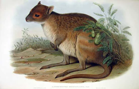
A vintage-style illustration showing a spectacled hare-wallaby resting near a small bush on open ground.
A historical scientific illustration of the spectacled hare-wallaby, a marsupial species found within the Pungalina-Seven Emu Sanctuary.

Pungalina-Seven Emu Sanctuary history and protected-area timeline

Pungalina-Seven Emu Sanctuary was formally established in 2009 when the Australian Wildlife Conservancy, with some support from the Wildlife Australia Fund, purchased Pungalina Station in the Northern Territory for conversion to a private conservation reserve. To create a property of meaningful scale and ecological coherence, the AWC simultaneously developed a partnership with Frank Shadforth, a Garawa man and the current owner of the neighbouring Seven Emu Station, who subleased 110,000 hectares of his property to the conservancy for wildlife conservation purposes. Seven Emu's coastal country links Pungalina inland to the Gulf of Carpentaria and makes the combined reserve ecologically continuous from plateau to coast.

The history of Seven Emu Station reaches back into the family's long pastoral tenure. Willie's son Frank, the seventh of ten children, now hosts visitors at the property and shares Garawa traditions, local natural history, and stories of European exploration of the region. Frank has also run self-funded programs for at-risk Aboriginal children, teaching skills such as cattle handling, fencing, and stock mustering, with funding later committed by the Northern Territory Government to expand these camps.

Pungalina-Seven Emu Sanctuary landscape and geographic character

The sanctuary's landscape is shaped by the strong geological and climatic contrast between its southern uplands and its northern coastal lowlands. In the south, Proterozoic sandstones form dissected plateaus and rugged escarpment country, with steep-sided gorges cut by rivers such as the Calvert. These gorges shelter pockets of dry rainforest within an otherwise eucalypt-dominated environment. An abrupt escarpment marks the descent to the coastal plains, where the terrain flattens into extensive floodplains and seasonal wetlands.

Across the floodplains, sandy red earths and shallow gravelly sands support eucalypt woodland with tussock and hummock grass understorey, grading into freshwater wetlands, littoral saline grasslands, and mangrove forests toward the Gulf. Coastal monsoon rainforest fringes parts of the shoreline, and the reserve includes around 55 kilometers of Gulf of Carpentaria coastline with associated intertidal mudflats. The Calvert River is the main hydrological artery, draining the plateau through gorges before meandering across the lowlands to reach the Gulf.

Pungalina-Seven Emu Sanctuary ecosystems, habitats, and plant life

Ecologically, Pungalina-Seven Emu sits within the Gulf Coastal bioregion, one of northern Australia's most distinctive tropical savanna systems. The dominant vegetation is eucalypt woodland over a tussock or hummock grass understorey, but this wooded matrix is broken by a striking variety of other habitats. Deep gorges contain dry rainforest refugia, while floodplain woodlands and freshwater wetlands line the major river systems. Closer to the coast, coastal monsoon rainforest appears in sheltered patches, and the littoral zone supports saline grasslands, mangroves, and tidal mudflats.

Seasonal rainfall and cyclonic events drive much of the ecological rhythm of the area, with monsoonal inundation feeding the floodplains and replenishing the wetlands that support waterbirds, reptiles, and fish. The combination of plateau, gorge, floodplain, freshwater, and marine-influenced habitats within one property creates an unusually complete cross-section of southern Gulf ecosystems and helps maintain ecological processes from runoff and freshwater flow to mangrove productivity and estuarine exchange.

Pungalina-Seven Emu Sanctuary wildlife and species highlights

An initial faunal survey of the sanctuary in 2009 recorded more than 231 vertebrate species, including 19 native mammals, 151 bird species, and 61 reptile and frog species, representing well over half of the roughly 430 native species predicted to occur on the property. Several threatened species have been documented there, including the masked owl, red goshawk, Gouldian finch, Carpentarian false antechinus, freshwater sawfish, Mertens' water monitor, and Gulf snapping turtle.

Other notable fauna include the purple-crowned fairy-wren, Australian bustard, short-eared rock-wallaby, spectacled hare-wallaby, and northern brown bandicoot, while the marine and estuarine environments off the beach host Indo-Pacific humpback dolphin, loggerhead and green turtles, shovelnose shark, giant trevally, and saltwater crocodiles. The reserve is also significant for its birds, helping to clarify the ranges of species such as the Pacific baza, little bronze-cuckoo, figbird, and white-breasted whistler in a coastal region that has historically been less well studied than the Top End to the west or Cape York Peninsula to the east.

Pungalina-Seven Emu Sanctuary conservation status and protection priorities

Pungalina-Seven Emu Sanctuary is classified as an IUCN Category II protected area, placing it in the same formal category as a national park, but it operates as a private conservation reserve managed by the Australian Wildlife Conservancy rather than a government park. Its conservation value lies in its sheer size and in the ecological continuity it maintains from sandstone plateau to Gulf coastline, protecting habitat types and ecological processes that are otherwise patchy across the southern Gulf region.

A key conservation feature of the reserve is its partnership model. The AWC holds the freehold of Pungalina Station and a sublease over a large portion of Seven Emu Station, allowing landscape-scale conservation planning across both properties while Indigenous ownership and stewardship remain intact. This arrangement supports conservation outcomes while keeping cultural connections to Country active. The sanctuary also plays a role in filling knowledge gaps for less-studied southern Gulf species and in protecting migratory and coastal species that depend on the relatively undisturbed mangroves, mudflats, and river systems of the reserve.

Pungalina-Seven Emu Sanctuary cultural meaning and human context

The sanctuary is closely tied to the cultural landscape of the Garawa (also spelled Garrwa) people, the traditional owners of much of this stretch of the southern Gulf coast. Seven Emu Station has been in the Shadforth family since 1953, when Garawa man William (Willie) Shadforth purchased the pastoral lease outright, becoming the first Indigenous Australian to acquire such a property outright for cash. Many Shadforth men partnered with local Garawa and Yanyuwa women, and the family became one of the early settler families of the region.

Willie Shadforth, an experienced cattle drover and horse trader, was known for winning a large sum on a long-shot outsider in the Melbourne Cup, then combining his winnings with prior Caulfield Cup winnings to purchase the lease from his friend George Butcher. He maintained traditional Garawa ceremonial and cultural knowledge, which he passed down through his son Frank and subsequent generations. Today, the sanctuary continues to function as a place where Garawa traditions, stories of European exploration such as Ludwig Leichhardt's expedition in 1844 to 1845, and contemporary conservation management intersect. The property also hosts a youth program that uses traditional skills and station work to support Aboriginal young people facing difficulties, an initiative later backed by Northern Territory Government funding.

Top sights and standout views in Pungalina-Seven Emu Sanctuary

Pungalina-Seven Emu Sanctuary combines an unusually complete spectrum of southern Gulf of Carpentaria habitats within a single private reserve, from rugged sandstone plateau and gorge country to floodplain woodlands, freshwater wetlands, coastal monsoon rainforest, mangroves, and tidal mudflats. It supports more than 230 recorded vertebrate species, including threatened taxa such as the Gouldian finch, masked owl, red goshawk, freshwater sawfish, and Gulf snapping turtle, and helps bridge knowledge gaps for southern Gulf bird populations.

The long-standing partnership between the Australian Wildlife Conservancy and the Garawa-owned Seven Emu Station gives the reserve a distinctive blend of professional conservation management and continuing Indigenous stewardship, together with an active pastoral and cultural presence. The result is a sanctuary whose value lies as much in its partnership model and cultural depth as in its remarkable ecological breadth.

Best time to visit Pungalina-Seven Emu Sanctuary

The sanctuary sits in a tropical monsoonal climate, so seasonal conditions shape the experience of the landscape and its wildlife. The wet season, roughly from December to March, brings most of the annual rainfall and frequent tropical cyclones, transforming inland rivers and floodplains and concentrating ecological productivity around freshwater wetlands and the coast. The dry season that follows tends to produce more accessible terrestrial conditions, with wildlife concentrating around remaining water sources and the Gulf shoreline and river mouths becoming focal points for bird and marine life.

Because Pungalina-Seven Emu is a working station and a privately managed conservation area rather than a publicly accessible national park, any visit depends on the arrangements of the Australian Wildlife Conservancy and the Shadforth family at Seven Emu Station. Travellers interested in the area should look to the dry-season months for generally more favourable conditions on the Gulf savanna, while keeping in mind that the wet season is when the floodplains, wetlands, and monsoonal forests are at their most biologically active.

Monthly climate preview

Long-term temperature and precipitation averages for Northern Territory geography

Pungalina-Seven Emu Sanctuary Climate Normals and Monthly Weather Patterns

Representative coordinate records show measured monthly temperature and precipitation rhythms across the protected landscape. Examining the full twelve-month profile provides complete historical averages for structured climate comparison.
Annual mean26 °C
21 °C30 °C
Jan29°
Feb28°
Mar28°
Apr27°
May24°
Jun21°
Jul21°
Aug22°
Sep26°
Oct28°
Nov30°
Dec30°
Warmest month
December

30 °C

Coolest month
July

20.8 °C

Wettest month
January

7.9 mm/day

Driest month
July

0 mm/day

Park location guide

Geography guide, regional context, and park location map for Pungalina-Seven Emu Sanctuary

Pungalina-Seven Emu Sanctuary park geography, regions, and map view in Australia

Understand where Pungalina-Seven Emu Sanctuary sits in Australia through a broader geographic reading of the surrounding landscape, nearby location context, and its mapped position within the national park landscape.

How Pungalina-Seven Emu Sanctuary fits into Australia

Australia is a constitutional monarchy and federal parliamentary democracy comprising six states and ten territories. With a population of nearly 28 million, it is one of the world's most urbanised countries, with most people concentrated on the eastern seaboard. The country has a high Human Development Index and is known for its cultural diversity, ancient Aboriginal heritage, and unique wildlife.

Wider geography shaping Pungalina-Seven Emu Sanctuary in Australia

Australia occupies the entire Australian continent, the island of Tasmania, and numerous smaller islands. It is the world's flattest and driest inhabited continent, featuring vast deserts in the interior (the Outback), tropical rainforests along the eastern coast, and a coastline bordering the Indian and Pacific Oceans.

Map view of Pungalina-Seven Emu Sanctuary

Use this park location map to pinpoint Pungalina-Seven Emu Sanctuary in Australia, understand its exact geographic position, and read its mapped placement within the surrounding landscape more clearly.

Pigeon | © OpenStreetMap contributors

Location context for Pungalina-Seven Emu Sanctuary

Northern Territory

Visualizing sandstone escarpments, savanna woodlands, and coastal tidal flats

Pungalina-Seven Emu Sanctuary Photos and Protected Landscapes

Examinations of Pungalina-Seven Emu Sanctuary imagery reveal the distinct environmental gradients spanning from rugged southern plateaus to mangrove-lined shores. Photographic records provide clear visual references for understanding remote protected habitats across the southern Gulf of Carpentaria.

A vintage-style illustration showing a spectacled hare-wallaby resting near a small bush on open ground.

Park atlas

Compare nearby protected areas and regional conservation zones across the Gulf of Carpentaria.

Parks Near Pungalina-Seven Emu Sanctuary and Connected Northern Australian Landscapes

Browsing other parks near Pungalina-Seven Emu Sanctuary reveals connected tropical savanna habitats and coastal wetlands across the surrounding region. Extending the geographic comparison helps trace broader ecological gradients from sandstone escarpments down to mangrove-lined tidal flats.
National parkNorthern Territory
About 114 km away#1 closest

Northwest

Barranyi (North Island) National Park: Northern Territory Island Protected Area and Landscape Context

Explore mapped geography and unique island terrain.

Barranyi (North Island) National Park is a remote national park in the Northern Territory, distinguished by its island setting in the Gulf of Carpentaria. The park's landscape features low coastal terrain, beaches, and dune formations, embodying a protected island ecosystem. Discover its mapped boundaries and geographic context within the vast northern Australian region, offering a specific example of island conservation and Indigenous land stewardship.

Area
53.81 km²
Established
1992
IUCN
II
Climate
Tropical
Marine protected areaQueensland
About 124 km away#2 closest

East

Gulf of Carpentaria Marine Park: Mapped Marine Protected Area and Tropical Geography

Submerged reefs, coastal basins, and Queensland marine habitats

The Gulf of Carpentaria Marine Park serves as a crucial protected zone in northern Australia, safeguarding complex marine environments. This atlas entry details its significant geographic features, ranging from productive coastal waters and sedimentary basins to isolated coral reefs. Gain a deeper understanding of the bathymetry and protected boundaries that support high levels of tropical marine biodiversity.

Area
23,771 km²
Established
2018
IUCN
VI
Relief
Lowland
National parkNorthern Territory
About 177 km away#3 closest

Northwest

Limmen National Park: Explore Australia's Northern Territory National Park & Protected Landscape

Discover mapped geography and regional context for this protected area.

Limmen National Park stands as a distinct protected area within the Northern Territory, offering valuable insights for geographic exploration. This national park serves as a focal point for understanding the mapped landscape and the broader regional context of protected lands in Northern Australia. Its identity as a national park contributes significantly to the geographic narrative of the territory, making it a crucial point for atlas-based discovery.

Area
9,369.26 km²
Established
2012
IUCN
II
Relief
Upland
National parkQueensland
About 266 km away#4 closest

Southeast

Boodjamulla National Park: Queensland National Park Geography and Mapped Boundaries

Explore the protected landscape and regional context of Boodjamulla National Park.

Boodjamulla National Park represents a key protected area within the northeastern Australian state of Queensland, offering users a detailed look at its geographic identity and mapped conservation boundaries. This national park serves as a focal point for understanding the distribution of protected lands and the unique natural terrain it encompasses within its regional setting. Discover its atlas-relevant features and protected landscape context.

Area
2,820 km²
Established
1985
IUCN
II
Relief
Highland
Wildlife reserveNorthern Territory
About 277 km away#5 closest

South

Connells Lagoon Conservation Reserve: Northern Territory Protected Landscape Atlas

Examining the ecological significance of Barkly Tableland grasslands

Connells Lagoon Conservation Reserve, also known as Dalgajini, encompasses a vital protected sample of the Barkly Tableland's Mitchell grassland and black soil plains. This wildlife reserve functions as a sanctuary for native grassland systems, maintaining a rare, cattle-free landscape that allows for the study of regional vegetation, rare avian species, and ancestral Wambaya cultural land patterns within the Northern Territory.

Area
258.9 km²
Established
1994
IUCN
Ia
Relief
Lowland
Protected areaNorthern Territory
About 297 km away#6 closest

North

Anindilyakwa Indigenous Protected Area: Mapping Northern Territory Conservation Landscapes

A vast island archipelago and sea Country ecosystem

The Anindilyakwa Indigenous Protected Area is defined by its significant island and marine geography within Australia's Northern Territory. This protected area preserves intact tropical woodland, coastal mangrove systems, and vital reef habitats through traditional Anindilyakwa stewardship, representing one of the largest Indigenous-managed landscapes in the region.

Area
10,000 km²
Established
2006
Relief
Lowland
Climate
Tropical
Nature reserveNorthern Territory
About 334 km away#7 closest

West

Bullwaddy Conservation Reserve: Protected Woodland Geography on the Northern Territory Sturt Plateau

Nature reserve boundary and landscape context

Bullwaddy Conservation Reserve represents an important protected woodland enclave on the Sturt Plateau. The terrain, defined by nutrient-poor lateritic soils, supports dense native thickets that stand out against the backdrop of the surrounding pastoral landscape. This nature reserve provides essential ecological integrity for local species and serves as a significant site for understanding the natural vegetation patterns of the Australian outback.

Area
115.3 km²
Established
2000
IUCN
Ia
Relief
Upland
National parkQueensland
About 398 km away#8 closest

South

Camooweal Caves National Park: Protected National Park Geography and Map Context in Queensland

Explore mapped boundaries and regional landscape character.

Camooweal Caves National Park represents a distinct protected landscape within Queensland, Australia. This national park offers users a focused entry into exploring its specific geographic features and mapped boundaries. Delve into the unique regional context and understand the atlas-level significance of this protected natural area, providing a clear view of its natural terrain and conservation identity.

Area
138 km²
Established
1988
IUCN
II
Relief
Upland

Common questions about visiting, size, designation, and location context for Pungalina-Seven Emu Sanctuary

Pungalina-Seven Emu Sanctuary FAQs for park facts, access, geography, and protected area context

Find quick answers about Pungalina-Seven Emu Sanctuary, including protected-area facts, park geography, trail and visitor context, and how the park fits into its surrounding country and regional landscape.
MoriAtlas Explorer

Continue Your Protected Areas Search Across the Global Atlas

Deepen your exploration by continuing the structured search for national parks and protected areas worldwide. Utilize the comprehensive filtering capabilities to compare different conservation landscapes and refine your understanding of global park geography. Discover more about the distribution and characteristics of protected natural areas.

Global natural geography