
Mori Atlas logo
Protected landscapePuszcza Biała

An extensive pine forest complex anchored between the Bug and Narew river corridors

Puszcza Biała Protected Landscape: Mapping the Lowland Forest Geography of Masovian Voivodeship

Puszcza Biała stands as one of the most significant forest complexes within the Mazovian Lowland of east-central Poland. This protected landscape is defined by its vast, sandy plains and continuous pine woodland, stretching strategically across the fork between the Bug and Narew rivers. The area serves as a vital ecological corridor, featuring a mosaic of habitats ranging from dry pine stands to moist alder carrs that delineate the regional terrain.

lowland forestpine forestMazovian lowlandriver confluenceNatura 2000nature reserves
A flat, colorful vector illustration of a forested valley with a tall waterfall cascading down a cliff face into a river, surrounded by pine trees and distant hills under a soft sun.

Puszcza Biała

Protected landscape

Park overview

Structured park overview, official facts, and landscape profile for Puszcza Biała

Puszcza Biała park facts, protected area profile, and essential visitor context

Review the core facts for Puszcza Biała, including designation, size, terrain, visitor scale, habitats, and operating context in one park-focused overview.

About Puszcza Biała

Puszcza Biała, sometimes called Puszcza Biskupia, is a large lowland forest complex in east-central Poland. It occupies a strategic position in the landscape of the Masovian lowlands, sitting in the broad fork between the Bug and the Narew, two major lowland rivers that together define much of the regional hydrology of northeastern Mazovia. The forest stretches roughly from Pułtusk in the northwest to Ostrów Mazowiecka in the east, covering approximately 85,000 hectares in total, of which about 51,000 hectares are forested.

Ecologically, the forest belongs to the Mazovian Lowland and is overwhelmingly dominated by Scots pine, which makes up more than 90 percent of the tree cover. This gives Puszcza Biała a strong visual identity: broad stretches of sandy, pine-covered plains characteristic of post-glacial lowland Poland. The remaining forest composition consists of mixed and deciduous pockets, often associated with wetter habitats along rivers, in valley bottoms, and around small wetlands.

Several rivers cross the forest, most importantly the Bug and Narew along its edges, as well as smaller streams such as the Brok, Zgorza Struga, and Wymakracz, which shape the internal drainage of the complex. The area includes fragments of the Nadbużański Landscape Park along the Bug and a number of nature reserves that protect specific ecological features, including Stawinoga, Popławy, Bartnia, and Wielgolas.

Although Puszcza Biała is not formally a national park, it is part of the Natura 2000 network, marking its importance for habitat and species protection at the European level. Its significance is therefore both ecological, as a large lowland pine forest with associated wetland and river habitats, and cultural, as a landscape deeply shaped by centuries of human management, conflict, and recovery.

Quick facts and research context for Puszcza Biała

Puszcza Biała is a large forest complex in the Mazowieckie Voivodeship of east-central Poland, situated in the fork between the Bug and Narew rivers between Pułtusk and Ostrów Mazowiecka. The broader forest area covers roughly 85,000 hectares, with about 51,000 hectares actually forested, a significant portion of which is privately owned. Pine dominates the tree cover, accounting for more than 90 percent of the forest's species composition. The area is registered within the Natura 2000 ecological network and overlaps partially with the Nadbużański Landscape Park. Multiple nature reserves sit within its boundaries, protecting representative fragments of the forest's ecological character.

Protection and recognition

Documented terrestrial protection scope and Natura 2000 recognition sources

Puszcza Biała Protection Status and International Recognition Data

Puszcza Biała maintains structured records detailing terrestrial protection status, management scope, and official designation frameworks. Verified sources incorporate Natura 2000 recognition data to establish a reliable baseline for conservation geography.
Park context

Deeper park guide and search-rich context for Puszcza Biała

Puszcza Biała history, landscape, wildlife, and travel context

Explore Puszcza Biała through its history, landscape character, ecosystems, wildlife, conservation priorities, cultural context, and seasonal travel timing in a structured park guide built for atlas discovery and search intent.

Why Puszcza Biała stands out

Puszcza Biała is best known as one of the most extensive lowland pine forests of the Mazovian region, lying in the confluence area between the Bug and Narew rivers. Its near-total dominance by Scots pine gives it a distinctive identity on the Polish lowlands, and its long history of bishop-owned forest management sets it apart from most other large forest regions in the country. The forest is also recognized for its inclusion in the Natura 2000 network and for the mosaic of nature reserves scattered across its interior.
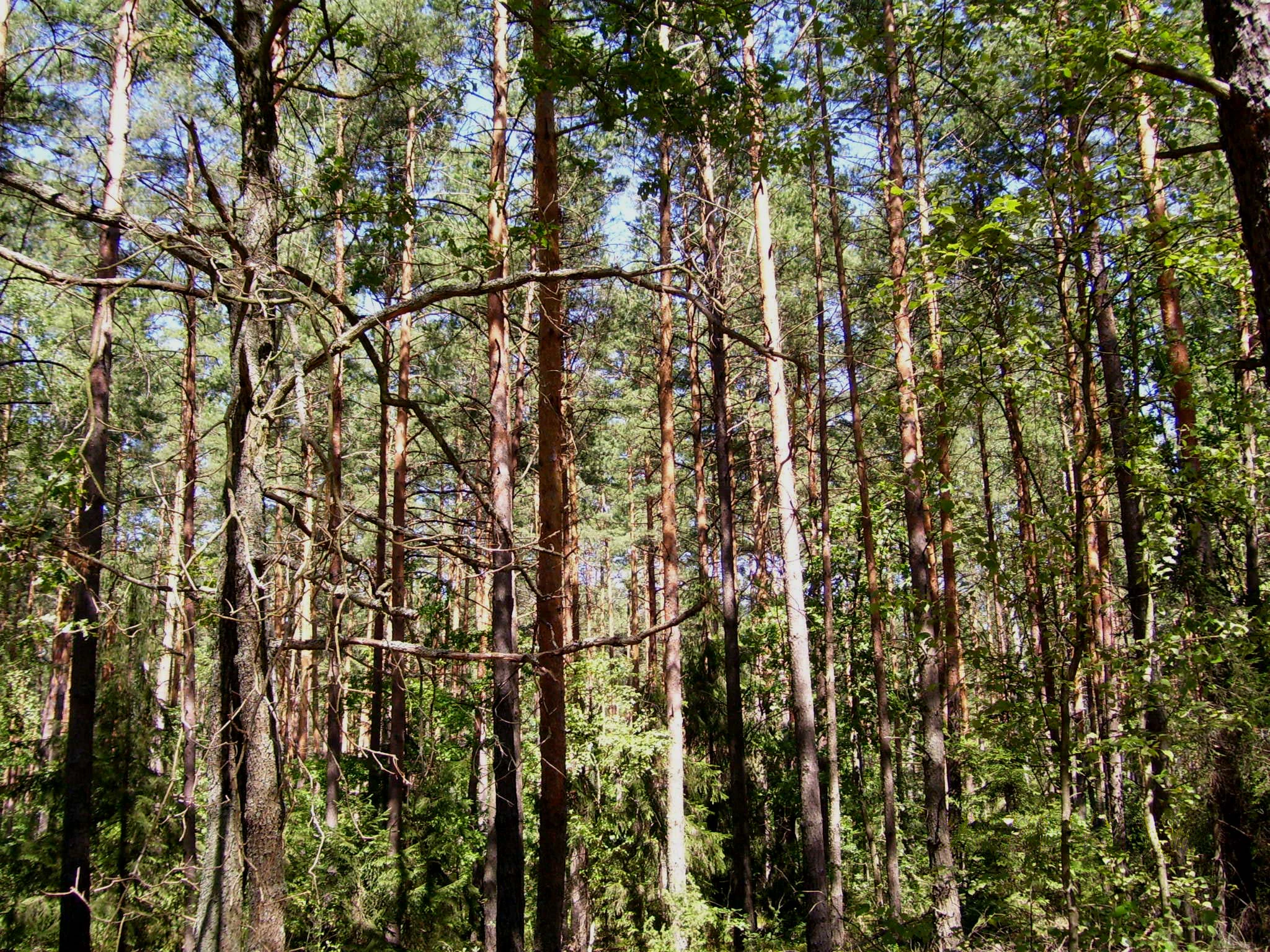
A dense stand of pine trees with tall, narrow trunks and green canopy, filling the frame in a forest setting.
A dense pine forest landscape in Puszcza Biała, Poland.

Puszcza Biała history and protected-area timeline

Puszcza Biała has a long and unusually well-documented history of human management. From the 13th century onward, the forest was the property of the Bishops of Płock, who resided in Pułtusk, Wyszków, and Brok. The bishops pursued a strict conservation policy to protect the forest's economic value. Bee-keeping, tar-making, potash production, and timber were major sources of income, and to preserve these resources, only settlers with forestry skills were allowed into the area, and they were permitted to clear only small, strictly defined plots called "nowiny." As a result, by the 18th century Puszcza Biała was among the least populated parts of Mazovia.

The forest was repeatedly a stage for military conflict. From medieval skirmishes through the Swedish Deluge and the Great Northern War, the dense woods served as a refuge and battlefield for local defenders and invading armies.

After the partitions of Poland, the forest was taken over by the treasury of the partitioning state. The 19th century brought rapid and destructive exploitation, replacing the original mixed and oak-rich stands with the pine-dominated landscape known today. Forest restoration began after 1880 and intensified in the interwar period and again after the Second World War, when active reforestation and management rebuilt the forest's productivity and ecological character.

Puszcza Biała landscape and geographic character

The landscape of Puszcza Biała is a classic post-glacial lowland scene: a wide, mostly flat expanse of sandy soils and pine forest stretching across the Mazovian plain. Elevation differences are subtle, and the scenery is shaped more by vegetation patterns and river corridors than by dramatic relief.

The dominant impression is of open, light pine forest with sandy pathways, dry patches, and areas of denser regeneration. Where soils are wetter, mixed deciduous stands and alder carrs develop, especially along the Bug, Narew, and the smaller rivers such as the Brok, Zgorza Struga, and Wymakracz. These river corridors break the uniformity of the pine stands and introduce richer, moister habitats into the broader forest matrix.

A distinctive sub-region within Puszcza Biała is known as Puszcza Czerwona, or Czerwony Bór, recognized for its particular forest character. Settlement is sparse and dispersed, with villages such as Budykierz, Brańszczyk, Brok, Długosiodło, Rząśnik, and Wyszków anchoring the forest's edges and interior clearings.

Puszcza Biała ecosystems, habitats, and plant life

Ecologically, Puszcza Biała is defined by its pine-dominated lowland forests, which represent a large continuous example of the sandy-soil woodland ecosystems typical of central Poland. More than nine-tenths of the forest composition is Scots pine, reflecting both the natural post-glacial substrate and the long legacy of historical management that favored pine regeneration.

Still, the forest is ecologically richer than its uniformity suggests. River valleys, small streams, and scattered wetlands support mixed and deciduous tree species, wet alderwoods, and riparian habitats that contrast with the dry pine matrix. These features contribute to the forest's biodiversity and provide important refuges within the broader pine-dominated landscape.

A network of nature reserves, including Stawinoga, Popławy, Bartnia, and Wielgolas, captures representative elements of this ecological mosaic, protecting specific habitats, forest types, or hydrological features. The forest's inclusion in the Natura 2000 network underlines its significance for European habitat and species conservation.

Puszcza Biała wildlife and species highlights

Puszcza Biała supports wildlife typical of central European lowland pine forests and river-valley habitats. The combination of large continuous forest, river corridors, and varied microhabitats creates conditions for both forest-dependent and wetland-associated species.

The pine-dominated stands, mixed pockets, and riparian zones host typical Mazovian forest fauna, including deer and smaller mammals, while birds associated with both extensive coniferous forest and riverside habitats find important refuge across the complex. The forest's quiet, sparsely populated character and the presence of protected reserves provide important conditions for wildlife stability in a region otherwise dominated by agriculture.

The nature reserves within the forest, such as Stawinoga and Popławy, are particularly important for protecting specific habitat conditions that support more specialized or sensitive species.

Puszcza Biała conservation status and protection priorities

Puszcza Biała holds notable conservation value despite not having the formal status of a national park. Its inclusion in the Natura 2000 network gives it European-level recognition as a habitat area worthy of long-term protection. The forest's large, connected extent, its relatively low human density, and its mosaic of dry pine, wet valley, and riparian habitats together create ecological conditions that are increasingly rare in lowland Poland.

Within the forest, several nature reserves provide targeted protection for representative habitats. These reserves protect specific forest or wetland features that contribute to regional biodiversity, while the broader landscape provides continuity for species that require large, unbroken forest patches.

Conservation of Puszcza Biała has been a long process, from the strict forest stewardship of the Bishops of Płock in earlier centuries, through the devastation of the 19th century, to modern reforestation and protected-area designation. The current conservation profile reflects both the recovery of the forest and the recognition of its continuing ecological importance.

Puszcza Biała cultural meaning and human context

Puszcza Biała is deeply interwoven with the cultural and political history of Mazovia. For centuries it was identified with the Bishops of Płock, who treated it as a productive but carefully protected estate, giving the forest its alternate name Puszcza Biskupia. Traditional forest crafts such as bee-keeping, tar-burning, and potash-making shaped both the economy and the cultural memory of the surrounding villages.

Sparse, carefully selected settlement, limited agricultural clearings, and a strong sense of forest as a managed resource defined local life well into the 19th century. The forest's recurring role as a refuge and battlefield during Sweden's invasions and the Great Northern War added another layer to its regional identity, remembered in local tradition and historical accounts.

Today, Puszcza Biała remains a defining element of the regional identity of the Mazowieckie Voivodeship, anchoring small towns and villages such as Pułtusk, Wyszków, Brok, Brańszczyk, and Ostrów Mazowiecka within a landscape that still feels strongly forested.

Top sights and standout views in Puszcza Biała

Puszcza Biała stands out as one of the largest and most continuous lowland pine forests of east-central Poland, occupying the strategic river-fork landscape between the Bug and the Narew. Its overwhelming Scots pine character gives it a strong, distinctive identity, while river corridors, wetlands, and nature reserves add ecological depth to an otherwise uniform-looking forest.

The forest's layered history, from bishop-owned stewardship, through 19th-century exploitation, to modern restoration and Natura 2000 recognition, gives it an unusually rich narrative depth for a lowland woodland. Its quiet, sparsely populated character and its anchoring role in the regional identity of Mazovia complete its profile as a significant natural area.

Best time to visit Puszcza Biała

Puszcza Biała is a lowland forest, so seasonal variation is moderate rather than dramatic. Late spring and early summer bring the freshest forest greenery, active birdlife, and comfortable walking conditions along forest roads and riverside paths. These months highlight the contrast between dry pine stands and the lush green of river corridors and deciduous pockets.

Autumn can also be rewarding, when pine-dominated landscapes take on a quieter, golden character and the forest's light, sandy paths remain easy to walk. Winter delivers a calm, snow-covered lowland forest scene, although visitors should expect typical lowland weather rather than dramatic winter conditions. Year-round, the forest's flat terrain and well-distributed settlements make exploration straightforward, though access to interior reserves may follow local regulations.

Monthly climate preview

Examine long-term temperature ranges and monthly precipitation patterns across representative coordinates.

Puszcza Biała Climate Normals and Annual Temperature Rhythm

Historical climatology records for Puszcza Biała indicate measured mean temperatures ranging from sub-zero winter lows to warm summer peaks alongside steady daily precipitation values. Reviewing the complete twelve-month meteorological profile provides deeper insight into long-term environmental patterns across the protected landscape.
Annual mean8 °C
-4 °C20 °C
Jan-4°
Feb-2°
Mar
Apr
May14°
Jun18°
Jul20°
Aug19°
Sep14°
Oct
Nov
Dec-2°
Warmest month
July

19.8 °C

Coolest month
January

-3.9 °C

Wettest month
July

2.4 mm/day

Driest month
March

1.3 mm/day

Park location guide

Geography guide, regional context, and park location map for Puszcza Biała

Puszcza Biała park geography, regions, and map view in Poland

Understand where Puszcza Biała sits in Poland through a broader geographic reading of the surrounding landscape, nearby location context, and its mapped position within the national park landscape.

How Puszcza Biała fits into Poland

Poland, officially the Republic of Poland, is a Central European country spanning from the Baltic Sea in the north to the Carpathian Mountains in the south. It borders Germany, Czech Republic, Slovakia, Ukraine, Belarus, Lithuania, and Kaliningrad Oblast. The country has a temperate climate, diverse landscapes, and is known for its rich history, cultural heritage, and strong economic position within the EU.

Wider geography shaping Puszcza Biała in Poland

Poland occupies 312,696 km2 in Central Europe, extending from the Baltic Sea coast in the north to the Sudetes and Carpathian Mountains in the south. It borders Germany to the west, Czech Republic and Slovakia to the south, Ukraine and Belarus to the east, and Lithuania and Kaliningrad Oblast to the northeast. The landscape includes lowland plains, uplands, and mountain ranges.

Map view of Puszcza Biała

Use this park location map to pinpoint Puszcza Biała in Poland, understand its exact geographic position, and read its mapped placement within the surrounding landscape more clearly.

Pigeon | © OpenStreetMap contributors

Location context for Puszcza Biała

Masovian Voivodeship

Visual reference for the pine stands, river corridors, and lowland terrain of Mazovia

Puszcza Biała Photos, Forest Landscapes, and Protected Scenery

Visual documentation captures the extensive Scots pine stands, sandy lowland soils, and river corridors defining the regional scenery of Puszcza Biała. Photographic exploration reveals the protected habitats and post glacial terrain characteristic of this expansive forest complex.

A dense stand of pine trees with tall, narrow trunks and green canopy, filling the frame in a forest setting.

Park atlas

Compare regional lowland forests, river valleys, and protected areas across the Mazovian plain.

Explore Other Parks Near Puszcza Biała and Surrounding Protected Landscapes

Continue browsing other national parks and protected areas near Puszcza Biała to examine similar lowland forest ecosystems and river confluence terrain. Comparing adjacent regional landscapes reveals broader patterns in habitat conservation across east-central Poland.
A flat vector illustration of a grassy meadow with yellow dandelions, a winding dirt path lined with fence posts, a forest in the midground, and large mountains in the background under a sky with pink clouds.
Protected areaMazovia Voivodeship
Park boundaries overlap#1 closest

Northwest

Bagno Pulwy: A Geographic Overview of the Mazovian Wetland and Peatland Mosaic

Protected marshland landscapes and Narew valley terrain

Bagno Pulwy represents an extensive lowland wetland in Poland's Mazovia region, characterized by its wide meadows, peat-rich soil, and intricate network of historical drainage canals. This protected area offers a distinct geographic contrast to the surrounding forested uplands, functioning as a vital open habitat situated within the broader Narew river valley drainage system.

Area
60 km²
Water
Major water bodies
Nature reserveMazovia Voivodeship
About 6.4 km away#2 closest

East

Rezerwat przyrody Mokry Jegiel: Protected Wetland Forest Geography in Mazovia Voivodeship

A rare mosaic of bog and riparian forest communities

Rezerwat przyrody Mokry Jegiel functions as a key protected area within the Lower Bug valley of east-central Poland. The reserve preserves an increasingly rare sequence of hydrologically sensitive forest types, ranging from nutrient-poor coniferous bogs to dense alder swamps and periodically inundated riparian forests, making it a focal point for regional wetland studies.

Area
1.161 km²
Established
2002
Relief
Lowland
Climate
Temperate
Nature reserveMazowieckie
About 20 km away#3 closest

Southeast

Rezerwat przyrody Moczydło: Protected Ornithological Landscapes in the Masovian Voivodeship

Mapping wetland habitats and forest bird refuges

Rezerwat przyrody Moczydło occupies a compact, ecologically significant forested area within the Mazowieckie region. As a designated faunistic reserve, it preserves critical breeding sites for water and marsh birds, contributing to the regional biodiversity and the expansive conservation efforts of the Nadbużański Landscape Park. This profile traces the reserve's geographic boundaries and its role in regional environmental protection.

Area
0.581 km²
Established
1991
Scope
Terrestrial
Water
Major water bodies
A wide watercolor illustration showing a river flowing through a grassy landscape with a line of trees in the background, rendered in soft greens, pinks, and purples.
Nature reserveMazovian Voivodeship
About 22 km away#4 closest

South

Rezerwat przyrody Dębina Nature Reserve: Exploring Protected Landscapes in Mazovian Voivodeship

A preserved oak-hornbeam forest featuring glacial erratics and ancient woodland

Rezerwat przyrody Dębina is a significant nature reserve situated in the Mazovian Voivodeship, noted for its 200-year-old oak stands and multi-species deciduous canopy. As the oldest protected area in the region, it preserves a vital remnant of the Polish Lowlands landscape, offering a dense, ecologically rich forest environment defined by subtle topography and unique Pleistocene glacial boulders.

Area
0.512 km²
Established
1952
Relief
Lowland
Climate
Temperate
Nature reservePodlaskie Voivodeship
About 27 km away#5 closest

Northeast

Rezerwat przyrody Dębowe Góry: Protected Sessile Oak Forest in Podlaskie Voivodeship

Ecologically intact lowland forest and rare plant habitat

Rezerwat przyrody Dębowe Góry stands as a protected sanctuary for light-loving sessile oak communities in Podlaskie Voivodeship. Its rolling lowland terrain and rich understory flora represent an essential fragment of Poland's natural woodland heritage, functioning as a key study area within the broader Czerwony Bór forest landscape context.

Area
0.993 km²
Established
2001
Relief
Lowland
Scope
Terrestrial
National parkMasovian Voivodeship
27 km away#6 closest

Southwest

Kampinos National Park: Geographic Profile and Protected Forest Landscape Map

Inland dune formations and wetland habitats in Masovian Voivodeship

The expansive woodland of Kampinos National Park represents a critical protected area in Poland, characterized by its parabolic sand dunes and low-lying marshes. Gain insights into the geomorphological features of this UNESCO biosphere reserve and trace the complex hydrological network that defines its unique forest environment.

Area
385.44 km²
Established
1959
IUCN
II
Relief
Lowland
A soft watercolor illustration of a marshy landscape with low rolling hills, scattered trees, and a winding stream, rendered in light green and yellow tones on a white background.
National parkMasovian Voivodeship
27 km away#7 closest

Southwest

Kampinoski Park Narodowy: Mapping the Inland Dune and Wetland Landscapes of Central Poland

A vital protected area in Masovian Voivodeship

The landscape of Kampinoski Park Narodowy is defined by the Grochalskie Piachy dune complex and diverse riparian habitats. This atlas entry covers the geological history and protected boundaries of this significant lowland forest, tracing the Vistula river valley's influence on the surrounding terrain and ecological character.

Area
385.443 km²
Established
1959
Visitors
1M annual
Relief
Lowland
A horizontal watercolor painting showing soft, layered green rolling hills and wooded ridges on a white background.
Nature reserveMasovian Voivodeship
About 29 km away#8 closest

West

Dolina Wkry Nature Reserve: A Protected River Gorge and Riparian Forest Ecosystem in Masovia

Geographic analysis of breakthrough valley landscapes and lowland river habitats

This protected area centers on a narrow, gorge-like section of the Wkra River, which cuts through the older land surfaces of the Masovian Voivodeship. The reserve protects vital floodplain forest fragments and demonstrates a clear transition from river-edge alder woodlands to drier plateau slopes, providing a compact example of lowland riverine geomorphology.

Area
0.244 km²
Established
1991
Relief
Lowland
Climate
Temperate

Common questions about visiting, size, designation, and location context for Puszcza Biała

Puszcza Biała FAQs for park facts, access, geography, and protected area context

Find quick answers about Puszcza Biała, including protected-area facts, park geography, trail and visitor context, and how the park fits into its surrounding country and regional landscape.
MoriAtlas Explorer

Continue Your Protected Areas Search Across the Global Atlas

Deepen your exploration by continuing the structured search for national parks and protected areas worldwide. Utilize the comprehensive filtering capabilities to compare different conservation landscapes and refine your understanding of global park geography. Discover more about the distribution and characteristics of protected natural areas.

Global natural geography