Peaks
Soum de la Hourquette
2,663 m

Analyzing the administrative reach, mountain terrain, and natural landscape features
Discover the precise geographic scope and administrative framework of Pyrénées National Park, spanning across Hautes-Pyrénées and Pyrénées-Atlantiques. This profile maps the 458 square kilometer core area, highlighting the diverse mountain relief, glacial systems, and stream networks that define this protected landscape.
Related tags
Highmountain wilderness protecting the Pyrenees' dramatic cirques, endemic wildlife, and UNESCO-listed landscapes
Pyrénées National Park is a French national park established in 1967, protecting a substantial portion of the Pyrenees mountains along the France-Spain border. The park spans the departments of Hautes-Pyrénées and Pyrénées-Atlantiques in southwestern France, covering approximately 458 square kilometers of high mountain terrain. It represents one of France's premier protected mountain landscapes, characterized by dramatic limestone cirques, deep glacial valleys, and some of the highest peaks in the French Pyrenees. The park is renowned for its exceptional geological heritage, where repeated glacial cycles during the Quaternary period carved spectacular U-shaped valleys and immense cirques such as the famous Cirque de Gavarnie. The limestone formations, originating from the Cretaceous and Eocene periods, have been subsequently shaped by tectonic uplift and erosion, creating the dramatic karst landscape that defines the region. The park shares a 100-kilometer boundary with Spain's Ordesa y Monte Perdido National Park, forming a transboundary protected area of significant international importance. The park's ecological significance is substantial, harboring over 70 mammal species, 124 plant species including 25 endemic to the Pyrenees, and a rich avifauna of approximately 200 bird species. Notable threatened species include the lammergeier, Pyrenean desman, Pyrenean chamois, capercaillie, and a small population of brown bears. In 1997, the eastern portion of the park was inscribed on the UNESCO World Heritage List as part of the Pyrénées-Mont Perdu transboundary site, recognizing both its natural and cultural landscape values.
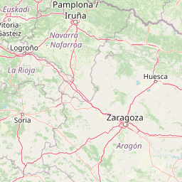
Regional mapping within Pyrénées-Atlantiques and Hautes-Pyrénées
Interactive protected area mapping and spatial dimensions
Catalog of mountain classifications and mapped hydrological entities
Peaks
2,663 m
Glaciers
Peaks
2,168 m
Mountain saddles
Peaks
1,815 m
Lakes
Interpreting mountain relief, partial forest cover, and terrain features
Mountains · Valleys · Canyon · Cave · Karst
Explore Mountain Landscapes and Connected Protected Areas Across the Pyrenees Region
Southeast

Explore its dramatic valleys, cliffs, and alpine geography.
Ordesa y Monte Perdido National Park is a critical protected area within the Pyrenean geography, defined by its spectacular glacial valleys, towering limestone massifs, and unique karst formations. As a National Park and UNESCO World Heritage Site, it offers a rich environment for exploring mapped terrain and understanding the interplay of geology and high-alpine ecosystems. Delve into the mapped boundaries and distinct landscape features that characterize this significant protected landscape.
Southeast

Glacial cirques, limestone canyons, and alpine pastoral heritage.
Spanning the high Pyrenees, Pyrénées-Mont Perdu represents a rare union of dramatic geological formations and human cultural heritage. The terrain features vertical limestone walls, deep carved canyons, and expansive cirques that host both diverse alpine ecosystems and active seasonal migration routes. This protected area remains a benchmark for studying the interplay between powerful glacial geography and historic mountain pastoralism in Europe.
Northwest
A roadless glacial valley in the French Pyrénées-Atlantiques
Vallée du Soussouéou offers a rare glimpse into a roadless Pyrenean landscape. This protected area features a classic glacial U-shaped valley, significant peatland ecosystems, and diverse alpine habitats that support Pyrenean fauna. As a quiet extension of the ecological network in the Western Pyrenees, the valley remains an important site for understanding mountain geography and glacial geomorphology in southwestern France.

East
A diverse protected landscape spanning the central Pyrenees of Occitanie.
This regional nature reserve provides a focused look at central Pyrenean mountain environments. Covering over 1,200 hectares, the area features a steep altitudinal gradient, blending working pastoral meadows with critical habitats such as rocky slopes, conifer forests, and glacial landforms. The site serves as a vital anchor within the broader network of protected mountain terrain found throughout the Occitanie region.
North
Regional protected landscape mapping in the French Pyrenees
Spanning over 5,000 hectares in the Occitanie region, the Réserve naturelle régionale du massif du Pibeste-Aoulhet serves as a critical biological corridor. This detailed record examines the massif's varied elevations, from lower broadleaf forests to high-altitude rocky cliffs, highlighting its status as one of the largest regional nature reserves in France.
East
Granitic massif geography and Pyrenean protected landscapes
Located in the heart of the Hautes-Pyrénées, this reserve captures the geological and biological essence of the Central Pyrenees. From the summit grasslands at 2,171 metres to the sheltered glacial basins, the terrain provides a comprehensive look at regional mountain ecosystems and Hercynian geological heritage.
East
Explore glacial lakes and winding waterways in Catalonia.
Aigüestortes i Estany de Sant Maurici National Park is a premier national park in the Pyrenees, celebrated for its extensive network of almost 200 glacial lakes and the dramatic natural beauty of the Sant Maurici lake. Its landscape is defined by high mountain terrain, characterized by U-shaped valleys, sharp ridges, and unique hydrological features like the Aigüestortes plain's meandering streams. This protected area in the Province of Lleida offers a rich setting for understanding alpine environments and Pyrenean geography through detailed mapping and atlas exploration.
Northwest
Examining the ecological terrain of a historic French millpond reserve
Explore the structured geography of Réserve naturelle régionale d'Errota Handia, a compact but ecologically significant nature reserve in the Pyrénées-Atlantiques. This resource provides a detailed look at the park boundaries, wetland-woodland mosaic, and the historic hydraulic infrastructure that defines this unique Basque landscape, offering an essential perspective for understanding regional conservation in southwestern France.
Delve deeper into the structured atlas data for Pyrénées National Park, a premier protected landscape in Hautes-Pyrénées. Understanding this park's unique terrain, its relation to surrounding French and Spanish protected areas, and its geological significance offers a richer geographic perspective. MoriAtlas provides the detailed mapping and regional context to fully appreciate its place within the Pyrenean mountain range and Western Europe's conservation tapestry.