Mori Atlas logo
Nature reserveQiangtang National Nature Reserve

Mapped terrain, alpine steppe boundaries, and regional geographic context within the northern Tibetan Plateau

Qiangtang National Nature Reserve: A Detailed Atlas of High-Altitude Plateau Wilderness and Protected Landscapes

(Xizang Qiangtang National Nature Reserve)

Qiangtang National Nature Reserve stands as one of the largest protected wilderness areas on Earth, encompassing vast high-altitude plains and high-elevation lakes across the northern Tibetan Plateau. This expansive landscape serves as a vital refuge for an intact assemblage of plateau herbivores and predators, maintaining ecological integrity across its rolling hills and arid steppe terrain. The reserve represents a continental-scale model for high-altitude conservation, characterized by extreme climates and a rugged, treeless environment that stretches across the remote interior of the Tibet Autonomous Region.

high-altitude plateaualpine steppenatural nature reserveIUCN Category VITibetan wildlifesnow leopard habitat

Qiangtang National Nature Reserve

Nature reserve

Park overview

Structured park overview, official facts, and landscape profile for Qiangtang National Nature Reserve

Qiangtang National Nature Reserve park facts, protected area profile, and essential visitor context

Review the core facts for Qiangtang National Nature Reserve, including designation, size, terrain, visitor scale, habitats, and operating context in one park-focused overview.

About Qiangtang National Nature Reserve

Qiangtang National Nature Reserve is one of the defining wilderness areas of high mountain Asia, occupying a huge swathe of the northern Tibetan Plateau in China's Tibet Autonomous Region. The name 'Qiangtang' translates from Tibetan roughly as 'northern plains,' a fitting description for an area dominated by rolling steppe and undulating uplands rather than dramatic mountain peaks. The reserve sits between the Kunlun and Hoh Xil ranges to the north and the Tangula and Gangdise ranges to the south, enclosing the heart of what is often simply called the Changtang.

At its core, the reserve exists to protect the integrity of an ecosystem adapted to extreme altitude and extreme cold. Average elevations exceed 4,800 meters, and winter nights regularly drop below minus 40 degrees Celsius. Summers are comparatively warmer but bring enough moisture to soften the ground, sometimes turning passage across the plains into a slow, muddy struggle for vehicles. The result is a landscape that has remained comparatively untouched, partly because access itself is difficult.

What truly sets Qiangtang apart is the breadth of plateau wildlife it shelters. It is one of the most important remaining areas for the Tibetan antelope, a species made famous by the shahtoosh trade, and the reserve also holds significant populations of wild yak, Tibetan wild ass, blue sheep, argali, and Mongolian gazelle. Predators such as the snow leopard, Tibetan wolf, and Tibetan brown bear complete the picture, while pikas form a small but critical base of the food chain. Vegetation is sparse, dominated by hardy grasses and sedges, especially needlegrass and kobresia, that hold the cold steppe together.

Qiangtang's protected status reflects both the international visibility of its wildlife and the practical challenges of safeguarding such a vast, sparsely populated region. Human habitation is minimal, restricted to a handful of Tibetan nomadic families and the staff who work against poaching. Beyond the formal boundary, a much larger buffer landscape extends conservation influence across nearly 500,000 square kilometers of the surrounding Changtang, making the broader area a continental-scale refuge for plateau biodiversity.

Quick facts and research context for Qiangtang National Nature Reserve

Qiangtang National Nature Reserve covers roughly 334,000 square kilometers of the northern Tibetan Plateau, making it the third largest terrestrial protected area in the world. It lies within the Tibet Autonomous Region of China and spans parts of Nagqu Prefecture and the Ali Prefecture. The reserve's average elevation exceeds 4,800 meters, and winter temperatures drop below minus 40 degrees Celsius at night.

The site was established in 1993 and elevated to national-level status in 2000, and it has been recognized internationally through the IUCN Category VI designation for sustainable resource use. Beyond the formally protected area, an additional buffer zone of nearly 500,000 square kilometers extends conservation influence across the broader Changtang region, an enormous area comparable in size to Spain.

Protection and recognition

Terrestrial protection metrics, establishment year, and management scope.

Qiangtang National Nature Reserve Protection Status and Designation History

Qiangtang National Nature Reserve maintains documented terrestrial protection status established in the year 2000. Public records track the official designation history, management scope, and recognition sources associated with the protected landscape.

Protection details

Protection scope
Terrestrial
Designated year
2000
Transboundary protection
No
Park context

Deeper park guide and search-rich context for Qiangtang National Nature Reserve

Qiangtang National Nature Reserve history, landscape, wildlife, and travel context

Explore Qiangtang National Nature Reserve through its history, landscape character, ecosystems, wildlife, conservation priorities, cultural context, and seasonal travel timing in a structured park guide built for atlas discovery and search intent.

Why Qiangtang National Nature Reserve stands out

Qiangtang is best known as one of the last strongholds of the Tibetan antelope and as a sanctuary for the full suite of large plateau herbivores and predators that depend on China's high steppes. It is also recognized for its enormous spatial scale, encompassing much of the northern Tibetan Plateau's cold, treeless wilderness and a network of high-elevation lakes. The reserve plays a defining role in the conservation story of the Tibetan Plateau. It supports wild yak, Tibetan wild ass, blue sheep, argali, and Mongolian gazelle alongside predators like the snow leopard, Tibetan wolf, and Tibetan brown bear. A large population of pikas underpins the food web, and the open steppe vegetation, dominated by needlegrass and kobresia, sustains one of the most complete assemblages of native Tibetan wildlife anywhere on Earth.
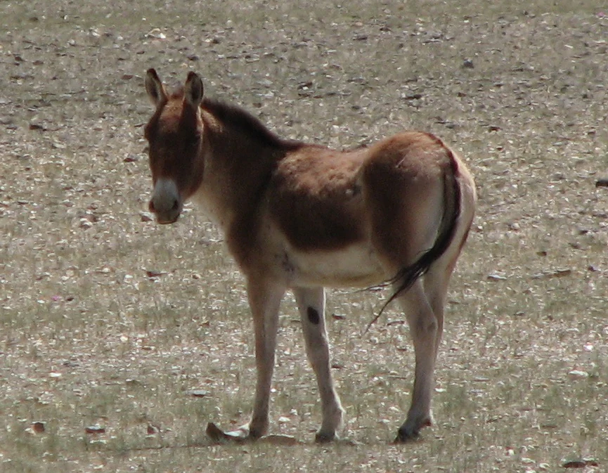
A brown and white wild ass standing on a sparse, rocky, and dry grassy plateau landscape.
A kiang, also known as a Tibetan wild ass, standing on the arid plateau landscape of Qiangtang National Nature Reserve.

Qiangtang National Nature Reserve history and protected-area timeline

The reserve's modern history began in 1993, when the Tibet Autonomous Regional Government approved the establishment of the Qiangtang Nature Reserve on the northern Tibetan Plateau. The founding was supported by the American wildlife biologist George Schaller, whose work on Tibetan antelope, wild yak, and snow leopard helped draw international attention to the region's ecological importance.

In April 2000, the State Council of the People's Republic of China elevated Qiangtang to the status of a national nature reserve, formalizing its protection at the highest domestic level. The reserve has since been classified by the International Union for Conservation of Nature as a Category VI protected area, a category that emphasizes sustainable use of natural resources alongside conservation objectives. The chronology of Qiangtang reflects a wider shift in conservation practice on the Tibetan Plateau, moving from ad hoc protection toward nationally and internationally recognized designations for very large, ecologically intact landscapes.

Qiangtang National Nature Reserve landscape and geographic character

The landscape of Qiangtang is defined less by dramatic peaks than by sweeping emptiness: a vast high-altitude plain broken by low ranges, gentle hills, and dozens of lakes. The plateau's average elevation sits above 4,800 meters, with the broader relief rising toward surrounding mountains that frame the reserve on every side. To the north lie the Kunlun and Hoh Xil ranges, while to the south rise the Gangdise and Nyainqêntanglha mountains, anchoring the reserve within the wider Tibetan Plateau.

The terrain is shaped by cold, dry climate and limited vegetation. Harsh winds and long winters dominate the weather, and winter temperatures are among the most extreme anywhere in Asia. Summer thaws bring short windows of warmth, but also enough moisture that the ground becomes soft and troublesome to cross. Within this setting, scattered lakes interrupt the steppe, providing vital water sources for the wildlife that crosses the plains and reinforcing the plateau character that defines Qiangtang.

Qiangtang National Nature Reserve ecosystems, habitats, and plant life

Ecologically, Qiangtang represents one of the most intact examples of high-altitude steppe and cold desert on Earth. Despite the harsh climate, the reserve supports a rich mosaic of habitats, including alpine grassland, sparse shrub cover, and wetland edges around its many lakes.

Vegetation is low-growing and adapted to cold, dry conditions, with needlegrass and kobresia species among the dominant plant groups. These hardy grasses form the foundation of an ecosystem that supports a remarkable density of large herbivores for such an extreme environment. The interplay between sparse plant cover and abundant grazing animals is one of the defining ecological patterns of the reserve, illustrating how the plateau has evolved in balance with its native megafauna.

Qiangtang National Nature Reserve wildlife and species highlights

Wildlife is at the heart of why Qiangtang exists. The reserve holds internationally important populations of Tibetan antelope, a species made globally famous by concerns over poaching for the shahtoosh shawl trade, and it remains one of the last large strongholds of the wild yak in its native plateau habitat. Alongside them roam the Tibetan wild ass, Himalayan blue sheep, argali, and Mongolian gazelle, completing an unusually full roster of native ungulates.

Predators follow the herds. Snow leopards roam the higher, rockier terrain bordering the plains, while the Tibetan wolf and the Tibetan brown bear stalk the open steppe. The Turkestan lynx is also present in the region, and smaller carnivores take advantage of the abundance of pikas, the small lagomorphs that form a critical base of the food chain. Taken together, the wildlife of Qiangtang offers one of the clearest surviving examples of a complete, naturally functioning Tibetan Plateau ecosystem.

Qiangtang National Nature Reserve conservation status and protection priorities

Qiangtang stands as a cornerstone of conservation on the Tibetan Plateau. Its roughly 334,000 square kilometers make it the third largest terrestrial protected area in the world, exceeded only by Northeast Greenland National Park and the Kavango-Zambezi Transfrontier Conservation Area. The reserve embodies a conservation strategy that relies more on sheer scale and remoteness than on intensive intervention: the landscape is so vast and harsh that very few people live within it, and so most of the wildlife is left to its own ecological dynamics.

The IUCN Category VI designation underlines a model that combines habitat protection with sustainable resource use, recognizing that the region has long supported traditional Tibetan nomadic pastoralism. Conservation work in the reserve has historically focused on anti-poaching patrols, particularly during the period when Tibetan antelope were heavily targeted for their underfur. The reserve's elevation to national status in 2000 marked an important institutional milestone, consolidating earlier regional protection into a permanent national-level designation. The surrounding Changtang buffer landscape, nearly twice the size of the reserve itself, extends this conservation influence across an area comparable to Spain.

Qiangtang National Nature Reserve cultural meaning and human context

Cultural identity within Qiangtang is shaped by the close relationship between the landscape and traditional Tibetan nomadic life. Although the reserve is vast and sparsely populated, a small number of Tibetan pastoralist families continue to live within its boundaries, maintaining patterns of seasonal migration that have existed for centuries.

Anti-poaching staff, many of them drawn from local communities, represent the main settled human presence in the reserve. The wider Changtang region has historically functioned as a zone of mobility and exchange, with pastoralists traveling between seasonal pastures and trading routes that followed the natural corridors of the plateau. Qiangtang's modern protected status is increasingly intertwined with these traditions, with conservation frameworks needing to accommodate long-standing pastoral land use alongside formal protection goals.

Top sights and standout views in Qiangtang National Nature Reserve

Qiangtang's standout qualities begin with its sheer size. Covering about 334,000 square kilometers, it ranks among the three largest terrestrial protected areas on the planet and exceeds the area of 183 countries. Its elevation, averaging more than 4,800 meters, places it among the highest major protected landscapes anywhere.

What elevates the reserve further is the completeness of its wildlife story. Few places on Earth still hold full assemblages of native Tibetan ungulates and their predators, including Tibetan antelope, wild yak, Tibetan wild ass, snow leopard, and Tibetan brown bear. The reserve's national-level status, its IUCN Category VI designation, and the much larger Changtang buffer zone together make Qiangtang a continental-scale model for protecting high-altitude wilderness.

Best time to visit Qiangtang National Nature Reserve

Qiangtang is a high-altitude, extremely cold environment where seasonal conditions shape any journey dramatically. Winters are long and brutal, with nighttime temperatures plunging below minus 40 degrees Celsius and severe cold limiting both wildlife visibility and overland access. For those familiar with such conditions, winter can still offer travel on frozen ground, and many travelers historically consider winter the easier season for crossing the plateau.

Summers are short and comparatively warmer, bringing a thin window of relative accessibility. However, rising temperatures also thaw the surface, softening the soil and turning large areas of the plain into difficult muddy terrain that can trap vehicles. The ideal timing therefore depends on whether a visitor prioritizes firmer ground underfoot or warmer temperatures, and any travel into the region requires serious preparation for high altitude, extreme cold, and limited infrastructure.

Monthly climate preview

Long-term temperature and precipitation records measured across representative highland elevations

Qiangtang National Nature Reserve Climate Normals and Annual Weather Patterns

Historical climate data from 1991 to 2020 outlines the measured temperature ranges and monthly precipitation cycles across Qiangtang National Nature Reserve. Examining the full twelve-month profile provides deeper insight into the long-term meteorological rhythm of this protected high-altitude landscape.
Annual mean-3 °C
-14 °C7 °C
Jan-14°
Feb-12°
Mar-8°
Apr-3°
May
Jun
Jul
Aug
Sep
Oct-2°
Nov-8°
Dec-12°
Warmest month
July

7.4 °C

Coolest month
January

-13.8 °C

Wettest month
July

4.2 mm/day

Driest month
December

0 mm/day

Park location guide

Geography guide, regional context, and park location map for Qiangtang National Nature Reserve

Qiangtang National Nature Reserve park geography, regions, and map view in China

Understand where Qiangtang National Nature Reserve sits in China through a broader geographic reading of the surrounding landscape, nearby location context, and its mapped position within the national park landscape.

How Qiangtang National Nature Reserve fits into China

China is a unitary communist state in East Asia, governed by the Chinese Communist Party. The country's capital is Beijing, while Shanghai is the largest city by urban population. China has 33 province-level divisions including provinces, autonomous regions, municipalities, and special administrative regions. The nation has a long history spanning thousands of years, with achievements including the invention of gunpowder, paper, printing, and the compass.

Wider geography shaping Qiangtang National Nature Reserve in China

China is located in East Asia, bordering fourteen countries: Russia, North Korea, Vietnam, Laos, Myanmar, India, Bhutan, Nepal, Pakistan, Afghanistan, Tajikistan, Kyrgyzstan, Kazakhstan, and Mongolia. The country spans diverse terrain including deserts, mountains, plateaus, and river valleys. Major river systems include the Yellow River and Yangtze River. The coastline stretches along the East China Sea, South China Sea, and Yellow Sea.

Map view of Qiangtang National Nature Reserve

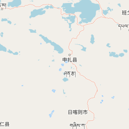
Use this park location map to pinpoint Qiangtang National Nature Reserve in China, understand its exact geographic position, and read its mapped placement within the surrounding landscape more clearly.

Pigeon | © OpenStreetMap contributors

Location context for Qiangtang National Nature Reserve

Tibet Autonomous Region
Recorded earthquake history

Review the Recorded Earthquake History for Qiangtang National Nature Reserve

Explore a chronological catalogue of seismic events documented near the borders of Qiangtang National Nature Reserve. These records, powered by MoriAtlas, provide valuable insight into the regional activity affecting this significant alpine landscape without implying future risk or specific hazard assessments.

Qiangtang National Nature Reserve Earthquake Records

Catalogued events

1,324 events

Strongest magnitude

Magnitude 7.5

Most recent event

Aug 27, 2026

This history includes earthquakes recorded inside the park or within 50 km of its borders

Visualizing alpine steppe terrain, high elevation lakes, and wildlife habitats

Qiangtang National Nature Reserve Photos and High Altitude Landscapes

Visual documentation of Qiangtang National Nature Reserve reveals sweeping high altitude plains, rugged mountain borders, and remote alpine steppe terrain. Examining these protected area photographs provides direct insight into the harsh environments and expansive natural habitats that sustain native Tibetan wildlife.

A brown and white wild ass standing on a sparse, rocky, and dry grassy plateau landscape.

Park atlas

Compare high-altitude alpine steppe habitats and regional conservation landscapes across the plateau

Explore Protected Areas and Other Parks Near Qiangtang National Nature Reserve

Browsing other protected areas near Qiangtang National Nature Reserve reveals connected high-altitude wilderness regions across the northern Tibetan Plateau. Examining adjacent alpine steppe environments provides vital geographical context for understanding regional wildlife ranges and cold desert terrain.
National parkQinghai
Park boundaries overlap#1 closest

Northeast

Sanjiangyuan National Park: Qinghai's High-Altitude Headwater Protected Landscape

Mapped geography of the Yellow, Yangtze, and Mekong river sources.

Sanjiangyuan National Park, situated in the high-altitude Qinghai region of China, is a crucial protected area established to safeguard the headwaters of three of Asia's most significant rivers: the Yellow, Yangtze, and Mekong. Covering an immense area with an average elevation exceeding 4,700 meters, the park preserves vital alpine wetlands, grasslands, and the source ecosystems that sustain hundreds of millions downstream. Its protected landscape identity is defined by its extreme elevation, vast marshlands, and its role as a critical water source, offering unparalleled opportunities for geographic and atlas-style exploration of pristine high-altitude terrain.

Area
190,700 km²
Established
2021
IUCN
II
Relief
Highland
Protected landscapeLadakh
About 237 km away#2 closest

West

Tso Moriri Protected Landscape: Ladakh Geography and Trans Himalayan Lake Atlas

High altitude wetland and cold desert plateau study

Trace the boundaries and ecological features of Tso Moriri, a major Ramsar site set within the high altitude cold desert of the Ladakh region. The landscape encompasses glacial streams, vast marshy deltas, and open steppe terrain that supports diverse wildlife and traditional pastoral land use.

Area
120 km²
Established
2002
Relief
Mountain
Climate
Arid
Protected areaLadakh
241 km away#3 closest

Northwest

Tso Kar Protected Area: Geographic Overview of Ladakh's High-Altitude Salt Lake

Mapping wetland margins, steppe ecology, and Himalayan basin terrain

Tso Kar is a distinct high-altitude salt lake system on the Rupshu Plateau. This protected area features a striking contrast between mineral-rich salt flats, freshwater lagoons, and surrounding alpine peaks. As a vital wetland, it supports diverse migratory bird populations and nomadic cultural landscapes, making it a key study of environmental complexity within the Indian Himalayas.

Area
22 km²
Established
2020
Relief
Highland
Climate
Alpine
National parkUttarakhand
About 251 km away#4 closest

West

Gangotri National Park: Uttarakhand National Park and Protected Landscape Discovery

Explore its mapped geography and regional protected area context.

Gangotri National Park serves as a crucial point of reference for understanding protected areas within Uttarakhand, India. As a national park, its defined geographic boundaries and the surrounding natural landscape provide valuable data for regional geography and atlas exploration. This entry offers a detailed look at the park's protected status and its role within the mapped terrain of the Himalayan region.

Area
2,390 km²
Established
1989
IUCN
II
Relief
Mountain
National parkLeh district
About 256 km away#5 closest

Northwest

Hemis National Park: Exploring India's Protected National Park Geography

Mapped boundaries and landscape context in Leh district.

Hemis National Park represents a distinct protected national park within the Leh district of India, offering unique geographic and landscape attributes for atlas exploration. This detailed entry focuses on the park's role as a conservation area, detailing its mapped extent and its contribution to the regional geography. Understand how Hemis National Park fits into the broader picture of protected lands, providing valuable context for those studying natural landscapes and territorial conservation across India.

Area
4,400 km²
Established
1981
IUCN
II
Relief
Mountain
A watercolor painting showing soft green hills and blue mountains bordering a calm lake under a pale sky.
Wildlife reserveHimachal Pradesh
About 315 km away#6 closest

West

Chandratal Wildlife Sanctuary: Geography and Protected Landscape Analysis

High-altitude Himalayan wildlife reserve and wetland

Examine the geomorphology of Chandratal Wildlife Sanctuary, home to one of India's most significant high-altitude lake systems. This detailed record highlights the sanctuary's role in conserving cold-arid alpine environments, from its glacial cirque and mountain scree to the seasonal wildflower carpets of the Western Himalaya.

Relief
Mountain
Climate
Alpine
Access
Moderate access
Scope
Terrestrial
National parkHimachal Pradesh
About 322 km away#7 closest

West

Pin Valley National Park: Remote Himalayan Cold Desert National Park in Himachal Pradesh

Explore its dramatic terrain and unique protected landscape in Spiti Valley.

Pin Valley National Park is a significant protected area covering roughly 675 square kilometers of the cold desert region in Himachal Pradesh, India. Established as a national park, it showcases a remote and rugged Himalayan landscape, characterized by its stark beauty, sparse vegetation, and extreme temperatures typical of high-altitude deserts. The park's geography spans dramatic mountain terrain, steep cliffs, and deep valleys, forming a vital habitat for endangered species and contributing to the unique ecological profile of the Cold Desert Biosphere Reserve.

Area
675 km²
Established
1987
IUCN
II
Relief
Mountain
National parkHimachal Pradesh
331 km away#8 closest

West

Great Himalayan National Park: Protected Landscape and Mapped Geography

Explore this national park's dramatic elevation and rich biodiversity.

Great Himalayan National Park is a vital protected area within India's Himachal Pradesh, celebrated for its exceptional biodiversity and dramatic mountain geography. This national park encompasses a remarkable range of elevations, creating distinct ecological zones from lower forest elevations to high alpine meadows and glacial zones. Its significance as a mapped protected landscape makes it essential for understanding regional natural heritage and conservation efforts within the Himalayas.

Area
1,171 km²
Established
1984
IUCN
II
Relief
Mountain

Common questions about visiting, size, designation, and location context for Qiangtang National Nature Reserve

Qiangtang National Nature Reserve FAQs for park facts, access, geography, and protected area context

Find quick answers about Qiangtang National Nature Reserve, including protected-area facts, park geography, trail and visitor context, and how the park fits into its surrounding country and regional landscape.
MoriAtlas Explorer

Continue Your Protected Areas Search Across the Global Atlas

Deepen your exploration by continuing the structured search for national parks and protected areas worldwide. Utilize the comprehensive filtering capabilities to compare different conservation landscapes and refine your understanding of global park geography. Discover more about the distribution and characteristics of protected natural areas.

Global natural geography