
Mori Atlas logo
Natural monumentRadobýl

Explore the distinct columnar basalt geology, dry grassland habitats, and panoramic Elbe valley vistas.

Radobýl Natural Monument: A Volcanic Landmark within the České středohoří of Ústecký kraj

(Přírodní památka Radobýl)

Rising as a prominent neovolcanic hill above the Elbe River, Radobýl serves as a significant natural monument within the broader České středohoří range. This site offers deep insight into volcanic processes through its dramatic exposed rock faces and historical quarry formations. The protected area preserves a complex mosaic of thermophilic grasslands, rocky steppes, and scree slopes that support specialized flora and fauna, standing as a landmark of geological and historical importance in the Ústecký kraj region.

volcanic hillbasalt geologycolumnar jointingdry grasslandsrock steppescree habitats
A flat, stylized digital illustration of a mountainous landscape featuring a cascading waterfall, a river in the foreground, pine trees, and cattails under a soft-colored sky.

Radobýl

Natural monument

Park overview

Structured park overview, official facts, and landscape profile for Radobýl

Radobýl park facts, protected area profile, and essential visitor context

Review the core facts for Radobýl, including designation, size, terrain, visitor scale, habitats, and operating context in one park-focused overview.

About Radobýl

Radobýl is one of the characteristic volcanic hills of the České středohoří, a low mountain range in northern Bohemia defined by Tertiary and Quaternary volcanism. The hill is a remnant of a subvolcanic body of nepheline basanite that intruded into Cretaceous marlstones, and erosion plus long-term quarrying have left its current asymmetric profile. The bare summit offers a near 360-degree view over Litoměřice, the Terezín basin, the Elbe river, and surrounding ridges of the České středohoří.

Geologically, the hill is a textbook example of columnar jointing in basaltic rock. The abandoned quarry exposes clearly developed, sometimes chaotically arranged basalt columns, formed when magma cooled under complex conditions. A small fissure cave, about ten meters long, was revealed near the contact between two lava flows during quarrying. These features are central to the scientific interest of the site and are explicitly cited as a reason for protection.

Ecologically, Radobýl stands out for its dry and semi-dry grasslands on warm, south- and southwest-facing slopes. The vegetation includes broad-leaved and narrow-leaved dry grassland, vegetation of silicate rock crevices, and communities on mobile scree. Soils are thin rendzina-type soils derived from basalt, and the local climate is distinctly warm and dry for central Europe, with relatively low precipitation and long, mild summers. The northern slope is wooded, with beech, oak, ash, and maple forming a deciduous forest that contrasts sharply with the open southern face.

Culturally and historically, the hill carries several layers of meaning. It is remembered for the death of the Czech Romantic poet Karel Hynek Mácha in November 1836, after he helped fight a fire in Litoměřice seen from the Radobýl summit while revising his final poem. The hill has also hosted a summit cross since the early seventeenth century, with the present steel cross installed in 1991. Nearby lies the Richard underground factory, a former limestone quarry used as a Nazi wartime production site and subcamp of Flossenbürg, parts of which have served as a low-level radioactive waste repository since the 1960s.

Quick facts and research context for Radobýl

Radobýl is a basalt hill in the České středohoří, in the Ústecký Region of the Czech Republic, near Litoměřice on the right bank of the Elbe. Its summit reaches approximately 399 meters above sea level, and the protected nature monument covers a small area focused on the southern face of the hill. The site was first designated in 1966 and re-declared in 2015, and it overlaps with a European Site of Importance. The hill forms part of a broader protected landscape area and is recognized for its dry grassland habitats, volcanic geology, and panoramic views.

Protection and recognition

Terrestrial conservation history, 2015 designation milestones, and Natura 2000 records

Radobýl Protection Status and Documented Conservation Designations

Radobýl holds documented terrestrial protection status established in 2015 alongside formal Natura 2000 recognition records. Official designation data details the administrative baseline and international recognition frameworks assigned to this protected terrain.

International recognition

Protection details

Protection scope
Terrestrial
Designated year
2015
Transboundary protection
No
Park context

Deeper park guide and search-rich context for Radobýl

Radobýl history, landscape, wildlife, and travel context

Explore Radobýl through its history, landscape character, ecosystems, wildlife, conservation priorities, cultural context, and seasonal travel timing in a structured park guide built for atlas discovery and search intent.

Why Radobýl stands out

Radobýl is best known for its exposed columnar basalt (čedič) formations left visible in the old quarry face, and for its dry, species-rich grasslands on warm south-facing slopes. The hill combines striking volcanic geology with open steppe-like vegetation and panoramic views over the Litoměřice basin and the Elbe valley. It is also remembered as the place where Karel Hynek Mácha reportedly finished his last poem shortly before his death in 1836.
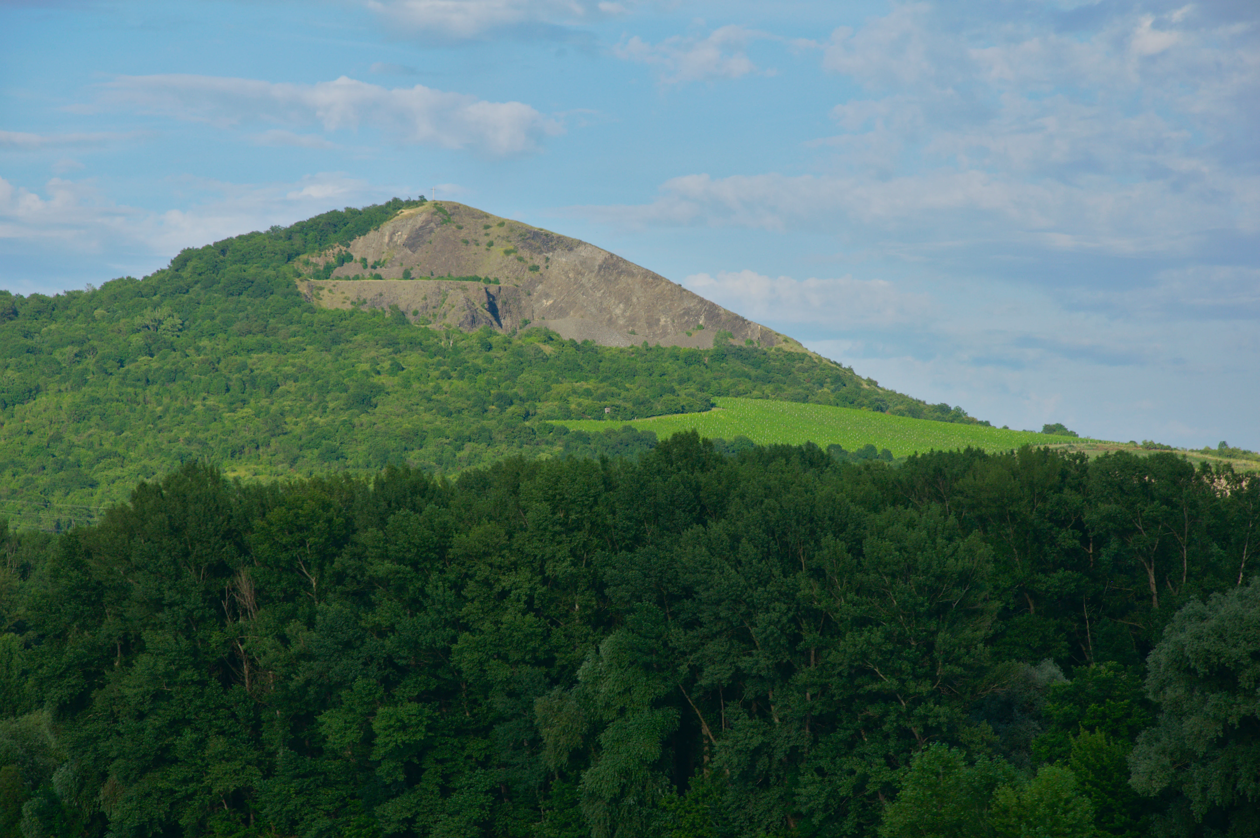
A green forested hill with a visible rocky, basaltic peak rising against a partly cloudy sky.
The distinctive volcanic hill of Radobýl viewed from the surrounding landscape.

Radobýl history and protected-area timeline

The hill has a multifaceted history that blends human use, literary memory, and shifting layers of formal protection. Stone quarrying on Radobýl began in the mid-nineteenth century and continued until after 1945, leaving the three-tiered Max, Georg, and Richard quarries that gave the hill its distinctive truncated western face. Adjacent slopes were once used as vineyards and pastures, with sheep grazing continuing until around 1980. The Richard mine beneath the neighboring Bídnice hill was founded in 1864 as a limestone operation; during the Second World War it was repurposed as an underground factory by the Nazi regime as a branch of the Flossenbürg concentration camp, where roughly 18,000 prisoners were forced to work in brutal conditions. After the war, the mine was partly converted in 1964 into a low-level radioactive waste repository expected to remain in use until 2070, and the underground spaces have been closed to the public since December 2001.

A key cultural marker on the hill is its summit cross. The first wooden cross was erected on 3 May 1622, made from oak; later oak crosses were replaced in 1862 by a cast-iron cross, which a storm destroyed in 1984. The current seventh cross, a steel structure standing about 7 meters tall with an arm span of over 3.5 meters and weighing around 1,100 kg, was installed on 29 October 1991. The hill also holds a poignant place in Czech literary history: on 23 October 1836, Karel Hynek Mácha reportedly observed the Litoměřice fire from Radobýl while working on his last poem Cesta z Čech, helped extinguish it, and later fell ill and died on 6 November 1836.

Formally, the site was first protected on 14 October 1966 as a protected natural feature (chráněný přírodní výtvor), re-designated on 17 April 1969 by the Ministry of Culture as a protected deposit (chráněné naleziště), and most recently declared a nature monument (přírodní památka) on 6 January 2015 by the administration of the České středohoří Protected Landscape Area. It appears in the Central List of Nature Conservation under number 356 and overlaps with a European Site of Importance.

Radobýl landscape and geographic character

Radobýl rises out of the lowland along the right bank of the Elbe, forming one of the more compact volcanic landmarks of the České středohoří. Its summit reaches around 399 meters above sea level, with the protected zone spanning roughly 278 to 399 meters in altitude. The hill's current silhouette is the result of the underlying geology combined with extensive quarrying on the western side, which removed large volumes of basalt and left steep, exposed rock faces.

These old quarry walls are now the most visually striking landscape feature of Radobýl, revealing columnar and in places chaotically arranged basalt jointing formed as the magma cooled. A short fissure cave, about ten meters long, developed where two lava flows met and was uncovered during extraction. The southern face shows clear signs of frost weathering, with frost cliffs, talus cones, boulder streams, and scree heaps, while the northern side carries a deciduous forest mantle dominated by beech, oak, ash, and maple. The resulting contrast between the bare, rocky south and the wooded north is a defining aspect of the hill's landscape character, framed by views toward Litoměřice, the Terezín basin, Lovosice, and the broader České středohoří ridge.
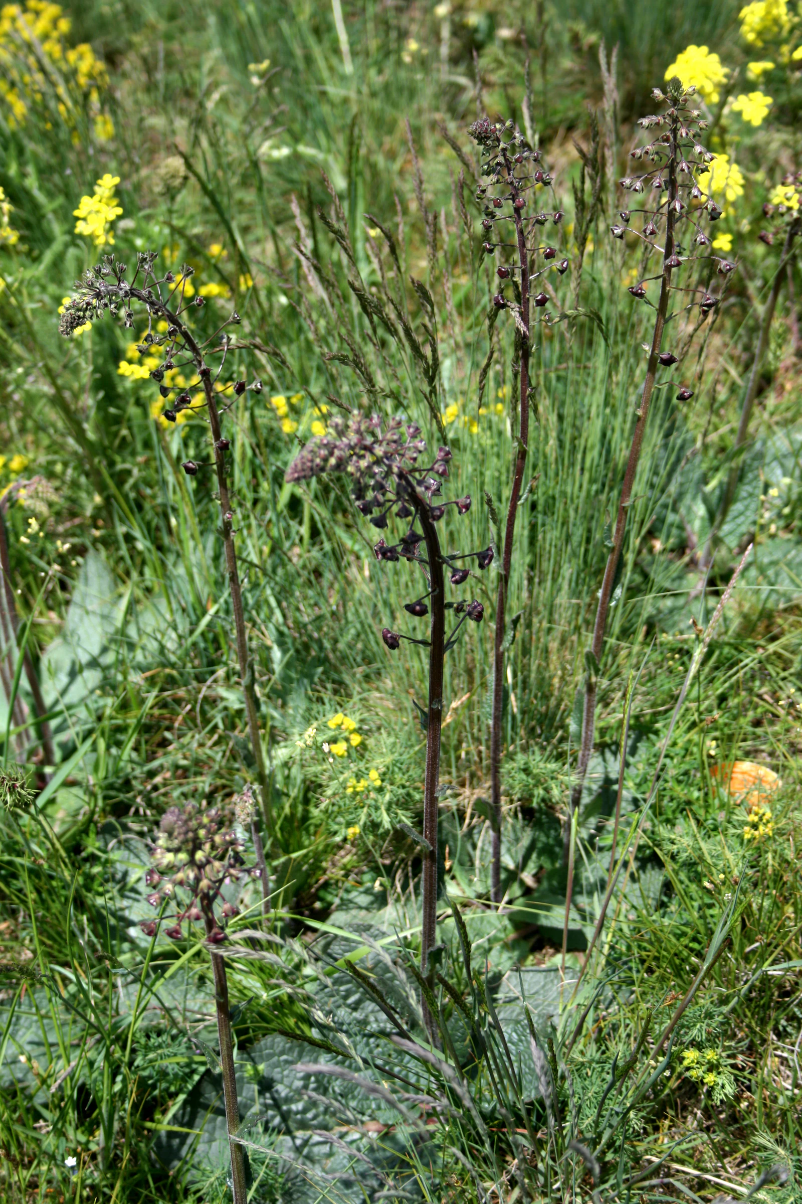
A cluster of purple mullein plants with dark purple flower spikes rising above green grass and small yellow wildflowers.
Purple mullein growing in the natural grassland of Radobýl.

Radobýl ecosystems, habitats, and plant life

The nature monument at Radobýl protects a compressed but ecologically rich mosaic of dry, sun-exposed habitats on volcanic substrate. The vegetation includes broad-leaved and narrow-leaved dry grasslands, communities of silicate rock crevices, and plant cover on mobile scree, all supported by thin pararendzina soils derived from the underlying basalt. This combination of warm, south-facing slopes and base-rich but well-drained volcanic rock gives the site a distinctly steppe-like character unusual for central Europe.

The climate of the area reinforces this ecological identity, with average January temperatures around minus 2 to minus 3 °C, July temperatures around 18 to 19 °C, fifty to sixty summer days per year, and relatively low annual precipitation of roughly 550 to 700 mm. The result is a landscape that supports warmth-loving plant and insect communities, including rare parasitic plants such as broomrapes alongside more characteristic dry-grassland species. The northern, forested section of the hill is ecologically distinct, providing shaded deciduous woodland that contrasts with the open south face and contributes additional habitat diversity within the broader protected landscape.
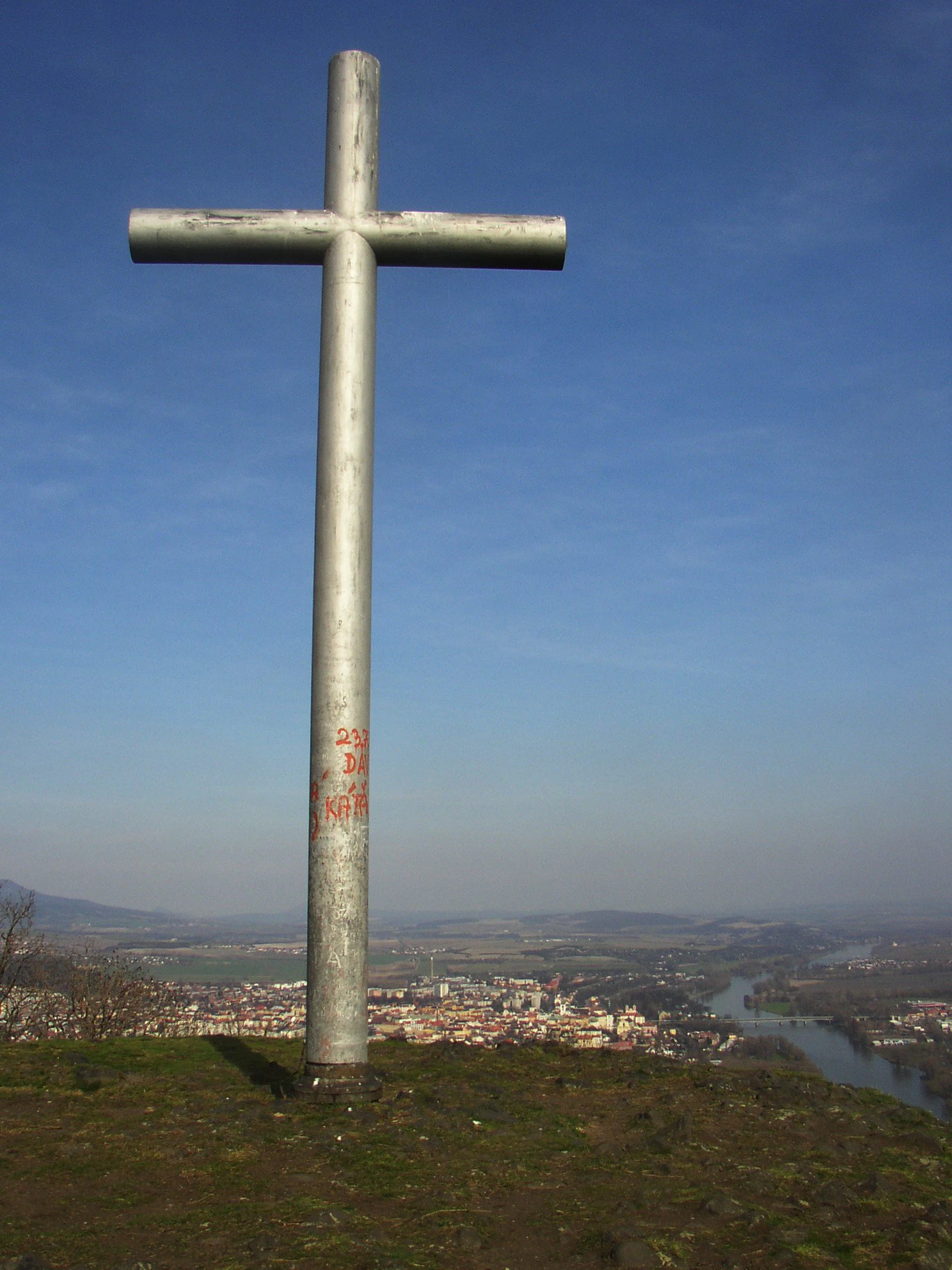
A tall, weathered metal cross stands prominently on a grassy hill summit against a blue sky, with a town and river visible in the distance.
A metal cross stands at the summit of Radobýl, offering a clear view of the landscape and the town below.

Radobýl wildlife and species highlights

The fauna of Radobýl reflects the site's warm, dry, open habitats and the surrounding mosaic of grassland, rock, and forest edge. Reptiles are particularly well represented, with common lizard, slow worm, and smooth snake present across much of the area. Among birds, the European stonechat breeds in the nature monument, and several other threatened species, including the corn bunting, barred warbler, and red-backed shrike, have been recorded in marginal parts of the site.

Invertebrate diversity is a major feature of the protected area. Grasshoppers such as the steppe grasshopper live in the steppe-like biotopes, while beetles include ground beetles, rove beetles, jewel beetles, darkling beetles, and the blister beetle. Butterflies are especially notable, with species like the bedstraw hawk-moth, swallowtail, scarce swallowtail, and several blue butterflies and fritillaries forming part of the site's conservation interest. Mammals are less prominent but include the hazel dormouse as a strongly threatened species recorded on the hill. Molluscs also maintain stable populations, adding to the overall picture of a small but unusually species-rich protected site.
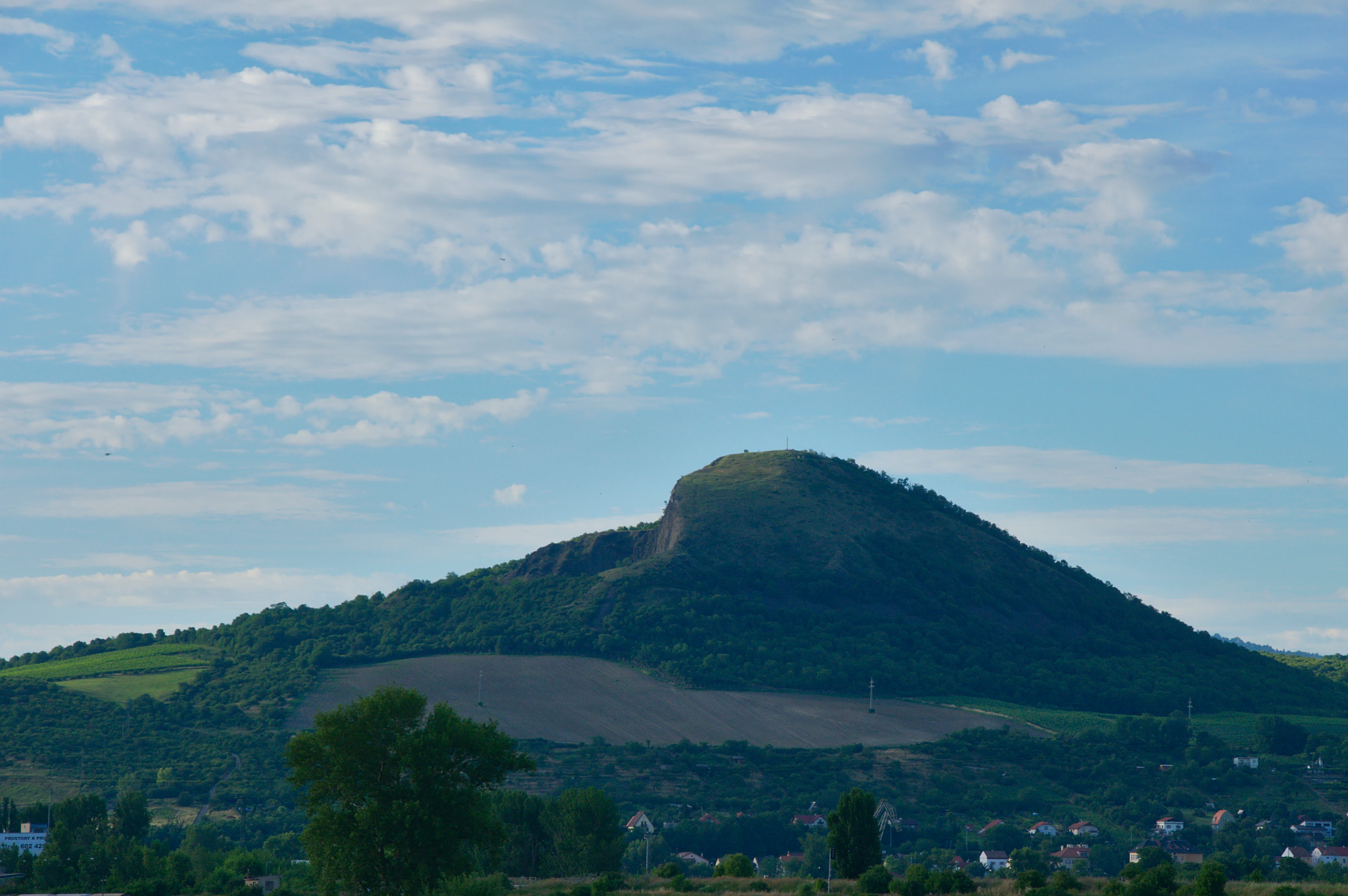
A wide shot of the volcanic Radobýl hill under a blue sky with scattered clouds, showing its grassy slopes and partially wooded base.
The distinctive profile of Radobýl hill in the Ústecký Region, a natural monument known for its volcanic geology.

Radobýl conservation status and protection priorities

Radobýl is protected both as an individual nature monument and as part of the wider České středohoří Protected Landscape Area, placing it within a layered national and European conservation framework. The southern portion of the hill has been under formal protection since 1966, with successive redesignations reflecting evolving nature conservation categories, and the current declaration in 2015 underscores the long-term importance of the site.

The conservation focus of Radobýl is twofold: geological and ecological. From a geological perspective, the site preserves an outstanding example of columnar basalt jointing in a nepheline basanite body, including a small fissure cave formed at a lava flow contact. From an ecological perspective, it safeguards dry grasslands, rock-steppe communities, and scree habitats that together support rare plants, butterflies, reptiles, and steppe-associated invertebrates. The site also overlaps with a European Site of Importance, indicating that its dry grassland and rocky-steppe habitats are recognized as valuable at the European level, not only within the Czech system.

Radobýl cultural meaning and human context

Radobýl carries a strong cultural resonance that goes beyond its natural values. It is most famously associated with the Czech Romantic poet Karel Hynek Mácha, who reportedly completed his final poem Cesta z Čech on the hill shortly before helping extinguish a fire in Litoměřice in October 1836 and dying of illness weeks later. The summit has long hosted a memorial cross, with the tradition stretching back to 1622, and the current steel cross stands as a continuous thread linking the hill's identity across centuries.

The surrounding landscape adds further layers of memory. Vineyards and pastures once clung to the lower slopes of Radobýl, while nearby Bídnice hides the Richard mine, a former wartime underground factory and Flossenbürg subcamp that is now partly a low-level radioactive waste repository. Together, these elements give Radobýl a cultural setting that blends Romantic literature, folk religious tradition, industrial heritage, and the difficult memory of the Second World War.

Top sights and standout views in Radobýl

The standout qualities of Radobýl are its exposed columnar basalt rock face in the former quarry, the warm dry grasslands covering its south side, and the near-panoramic view over the litoměřice basin and the Elbe. Its protected status, layered inside the České středohoří Protected Landscape Area, reflects both geological and ecological significance. The hill is also notable for combining ecological richness with a strong literary and historical identity, anchored by the Karel Hynek Mácha legend and a summit cross tradition reaching back to the seventeenth century.

Best time to visit Radobýl

Radobýl can be appreciated year-round, but its character shifts meaningfully with the seasons. Late spring and early summer are particularly rewarding for the dry grasslands, when steppe plants and butterflies are most active on the warm south-facing slopes. Autumn brings cooler air and often clearer visibility, making the panoramic views over Litoměřice and the Elbe valley especially distinct. Winter visits emphasize the bare rock of the quarry face and the stark contrast between the snow-touched landscape and the wooded northern side, while the summit cross remains accessible via nearby marked trails.

Monthly climate preview

Review measured monthly weather averages and annual temperature progression for Radobýl

Radobýl Climate Normals: Long Term Temperature and Precipitation Patterns

Long-term NASA data shows monthly temperature averages ranging from negative values in winter months to over thirty degrees in mid-year peaks alongside steady precipitation rates. Reviewing the complete twelve-month weather profile provides deeper insight into the baseline climate normals for Radobýl.
Annual mean9 °C
-2 °C20 °C
Jan-2°
Feb-1°
Mar
Apr
May14°
Jun18°
Jul20°
Aug19°
Sep14°
Oct
Nov
Dec-1°
Warmest month
July

19.8 °C

Coolest month
January

-2.3 °C

Wettest month
July

2.4 mm/day

Driest month
February

1 mm/day

Park location guide

Geography guide, regional context, and park location map for Radobýl

Radobýl park geography, regions, and map view in Czechia

Understand where Radobýl sits in Czechia through a broader geographic reading of the surrounding landscape, nearby location context, and its mapped position within the national park landscape.

How Radobýl fits into Czechia

Czech Republic is a landlocked Central European country with a population of approximately 10.9 million people. The nation was established as an independent state on January 1, 1993, following the dissolution of Czechoslovakia. Its capital and largest city is Prague, with other major urban centers including Brno, Ostrava, Plzeň, and Liberec.

Wider geography shaping Radobýl in Czechia

The Czech Republic is a landlocked country in Central Europe. It is bordered by Germany to the west, Austria to the south, Poland to the northeast, and Slovakia to the southeast. The landscape is predominantly hilly, with the territory covering 78,871 square kilometers.

Map view of Radobýl

Use this park location map to pinpoint Radobýl in Czechia, understand its exact geographic position, and read its mapped placement within the surrounding landscape more clearly.

Pigeon | © OpenStreetMap contributors

Location context for Radobýl

Ústecký kraj
Recorded earthquake history

Explore Historical Earthquake Records Associated with Radobýl

Browse the recorded seismic history associated with the location of Radobýl to view past event data. This collection provides access to documented earthquake information near the monument, helping users evaluate regional seismic records within the broader geography of the České středohoří.

Radobýl Earthquake History

Catalogued events

18 events

Strongest magnitude

Magnitude 3.8

Most recent event

May 4, 2000

This history includes earthquakes recorded inside the park or within 50 km of its borders

Examine exposed basalt rock faces, dry grasslands, and protected highland scenery.

Radobýl Photos and Visual Exploration of Volcanic Landscapes

Visual documentation reveals the distinct volcanic terrain, rocky steppe habitats, and steep quarry walls that define Radobýl. Photographic reference helps visitors understand the unique geological formations and panoramic Elbe valley viewpoints.

A green forested hill with a visible rocky, basaltic peak rising against a partly cloudy sky.

A close-up view of a steep cliff face featuring weathered basalt columns in an abandoned quarry, with a large scree slope of loose rock below.

A cluster of purple mullein plants with dark purple flower spikes rising above green grass and small yellow wildflowers.

A tall, weathered metal cross stands prominently on a grassy hill summit against a blue sky, with a town and river visible in the distance.

A wide shot of the volcanic Radobýl hill under a blue sky with scattered clouds, showing its grassy slopes and partially wooded base.

A wide angle view of the steep basalt rock face of Radobýl hill, with loose rock scree at the base and sparse vegetation in the foreground.

Park atlas

Compare regional volcanic landscapes, basalt formations, and protected reserves

Explore Other Parks Near Radobýl and Protected Areas in the Surrounding Region

Browsing other parks near Radobýl reveals connected protected landscapes and neighboring volcanic terrain across northern Bohemia. Comparing these regional reserves provides deeper context on local geology, dry grasslands, and river valley habitats.
Nature reserveUstecky Region
11 km away#1 closest

Southwest

Vrch Hazmburk Nature Reserve: Geographic Atlas and Protected Landscape Overview

Volcanic terrain and steppe ecosystems in the Ustecky Region

Vrch Hazmburk stands as a notable example of Neovolcanic geology, characterized by steep basalt slopes, frost-shattered cliffs, and a rich mosaic of dry grassland habitats. Located in the Ustecky Region, this protected site preserves a critical transition zone for thermophilic plants and rare invertebrates, offering a clear view of how geological movement and long-term land stability define the Bohemian lowland landscape.

Area
0.604 km²
Established
2011
IUCN
IV
Relief
Mountain
A horizontal watercolor painting depicting a soft-focus landscape with light green trees and low rolling hills under a pale, warm-toned sky.
Protected landscapeLitoměřice District
About 13 km away#2 closest

South

Dolní Poohří Nature Park: Protected Landscape and River Geography

A riparian corridor through the Litoměřice District

The landscape of Dolní Poohří Nature Park follows the irregular arc of the lower Ohře River across the Bohemian plain. Its narrow boundaries protect a functional floodplain ecosystem characterized by silted oxbows, gravel banks, and rare forest fragments. This atlas entry details the geographic features, protected status, and the interplay between the active river channel and the historic townscapes found along its banks.

Area
40 km²
Established
2001
Relief
Lowland
Climate
Temperate
A horizontal watercolor painting showing rolling green hills in the distance and colorful, stylized vegetation in the foreground.
Nature reserveÚstí nad Labem Region
About 15 km away#3 closest

Northwest

Rač Nature Reserve: Volcanic Slopes and Protected Habitats in Ústí nad Labem

Geomorphology and ecological succession in the České středohoří range

Rač Nature Reserve is a landmark for volcanic ecology, preserving a mosaic of trachyte rock formations and open grassland on the slopes of Hradiště u Habří. This protected area serves as a vital refuge for rare steppe-like flora and a high concentration of thermophilic insect species, offering a concentrated look at natural land recovery and geological history in northern Bohemia.

Area
0.154 km²
Established
1953
IUCN
IV
Relief
Mountain
Natural monumentLitoměřice District
16 km away#4 closest

South

Vrbka Natural Monument: Exploring Protected Limestone Habitats and Bohemian Lowland Geography

A rare botanical reserve in the Litoměřice District of the Czech Republic

Vrbka Natural Monument protects a significant 15.5-hectare expanse of warm limestone slopes and dry meadows. This geographic landmark serves as an essential repository for rare orchid species and diverse insect populations, functioning as a representative habitat patch within the intensively cultivated landscapes of the surrounding region.

Area
0.155 km²
Established
2013
IUCN
IV
Relief
Upland
A horizontal watercolor illustration depicting a soft, rolling landscape with green hills, a small winding stream, and meadow vegetation on a white background.
Natural monumentÚstecký kraj
17 km away#5 closest

South

Na Dlouhé stráni Natural Monument: Regional Protected Area and Botanical Landscape

A conservation-focused look at the Mšenský potok valley slope

Na Dlouhé stráni is a designated natural monument in the Czech Republic, renowned for its concentration of thermophilous grassland flora. This protected area, located near Mšené-lázně, preserves a specific slope habitat that supports declining plant species. The site offers an important look at regional conservation efforts and the mapping of small-scale protected habitats within the diverse Ústecký kraj geography.

Area
0.126 km²
Established
2012
IUCN
IV
Relief
Lowland
Natural monumentÚstecký kraj
18 km away#6 closest

East

V kuksu Natural Monument: Mapping Protected Ravine Landscapes in Ústecký kraj

A vital orchid-rich habitat and Natura 2000 conservation area

V kuksu protects a specialized woodland ravine habitat characterized by stable humidity and shaded slopes. This natural monument serves as an important regional site for the lady's slipper orchid, contributing to biodiversity within the Litoměřice district through its status as a protected area of European importance.

Area
0.21 km²
Established
2011
IUCN
IV
Relief
Upland
Natural monumentÚstecký kraj
20 km away#7 closest

Southwest

V hlubokém Natural Monument: Protected Calcareous Landscapes and Terrain in Ústecký kraj

A study of rare sesleria grasslands and opuka slope geography

V hlubokém serves as a significant protected site in the Czech Republic, encompassing twenty hectares of hillside defined by soft calcareous opuka rock. This natural monument is recognized for its rare sesleria grasslands and thermophilic plant assemblages that contrast with the surrounding woodland. The protected area forms a critical link in the broader geography of the Débeř valley, offering a clear example of localized botanical diversity supported by unique alkaline substrate conditions.

Area
0.202 km²
Established
1947
IUCN
III
Relief
Upland
A watercolor illustration of rolling hills and a green landscape with a soft, abstract style.
Nature reserveLiberec Region
About 25 km away#8 closest

Northeast

Ronov Nature Reserve: Protected Volcanic Geography and Scree Forest Ecosystems in Liberec Region

Volcanic landmark with basalt talus slopes and historic ruins

Ronov rises as a distinctively shaped basalt cone from the rolling terrain of the northern Czech Republic. This nature reserve offers significant insight into the geological and botanical character of the Ralská pahorkatina, featuring extensive stone seas and rare plant habitats situated around ancient castle remains.

Area
0.09 km²
Established
1995
IUCN
IV
Relief
Mountain

Common questions about visiting, size, designation, and location context for Radobýl

Radobýl FAQs for park facts, access, geography, and protected area context

Find quick answers about Radobýl, including protected-area facts, park geography, trail and visitor context, and how the park fits into its surrounding country and regional landscape.
MoriAtlas Explorer

Continue Your Protected Areas Search Across the Global Atlas

Deepen your exploration by continuing the structured search for national parks and protected areas worldwide. Utilize the comprehensive filtering capabilities to compare different conservation landscapes and refine your understanding of global park geography. Discover more about the distribution and characteristics of protected natural areas.

Global natural geography