

Mori Atlas logo
Wildlife reserveRasa Island Wildlife Sanctuary

Tracing the mapped boundaries, mangrove habitats, and coral island terrain within the Sulu Sea

Rasa Island Wildlife Sanctuary: A Comprehensive Geographic Atlas of a Palawan Wildlife Reserve

Rasa Island Wildlife Sanctuary serves as a primary conservation landscape in the western Philippines, encompassing a compact mosaic of mangrove forests, coastal woodland, and exposed coral banks within the Sulu Sea. Located just off the Palawan mainland, this protected area preserves a vital nexus of marine and terrestrial habitats that support diverse bird populations and critical nesting grounds. Understanding its geographic footprint reveals a unique transition from reef-fringed coastlines to open marine waters, highlighting the importance of integrated island and marine protection in the Palawan archipelago.

island sanctuarymangrove forestcoastal forestcoral banksSulu Seaseabird habitat

Rasa Island Wildlife Sanctuary

Wildlife reserve

Park overview

Structured park overview, official facts, and landscape profile for Rasa Island Wildlife Sanctuary

Rasa Island Wildlife Sanctuary park facts, protected area profile, and essential visitor context

Review the core facts for Rasa Island Wildlife Sanctuary, including designation, size, terrain, visitor scale, habitats, and operating context in one park-focused overview.

About Rasa Island Wildlife Sanctuary

Rasa Island Wildlife Sanctuary protects a small island and its surrounding coastal waters in the Sulu Sea, off the southern Palawan coast of the Philippines. The sanctuary sits roughly 91 kilometers southwest of Puerto Princesa, the capital of Palawan province, and approximately 2 kilometers offshore from the municipality of Narra. Accessible by a short boat ride from the port of Barangay Panacan, the protected area combines terrestrial island habitats with a marine buffer that makes it both a forest and sea refuge.

The protected territory encompasses the entire island of Rasa, which covers about 8.34 square kilometers, together with surrounding marine waters, bringing the total sanctuary area to roughly 19.83 square kilometers. The island's vegetation is dominated by mangrove forests, which occupy around 5.60 square kilometers of the land area, complemented by coastal forests of about 1.75 square kilometers and small areas of cultivated land. Just offshore, low coral banks rise from the sea in places, adding to the diversity of the protected seascape.

Rasa Island's identity as a sanctuary is inseparable from its birdlife. The island supports a rich coastal avifauna of around 104 species, including grey imperial pigeons, Palawan black drongos, and Mantanani scops owls. Among these, the Philippine cockatoo or red-vented cockatoo stands out as the sanctuary's signature species; the protected area holds the world's highest known density of free-living individuals of this threatened parrot.

Beyond its role for birds, Rasa Island also functions as a nesting ground for green and hawksbill sea turtles, while the surrounding waters are part of a coastal ecosystem where dugongs have been recorded. This combination of island forest, mangrove, coral bank, and open sea makes the sanctuary a compact but highly representative example of Palawan's coastal biodiversity.

Quick facts and research context for Rasa Island Wildlife Sanctuary

Rasa Island Wildlife Sanctuary is a combined land and marine protected area located off the municipality of Narra on the southern coast of Palawan in the western Philippines. It was formally established on 15 February 2006 through Presidential Proclamation 1000 under Republic Act 7586, the law that created the National Integrated Protected Areas System.

The sanctuary arose from a pilot conservation program that had been running on the island since 1998 under the Katala Foundation, focused especially on safeguarding nesting birds. Rasa is internationally recognized for hosting the world's highest density of wild Philippine cockatoos, and it is also an important nesting site for green and hawksbill turtles within a Sulu Sea seascape that supports dugongs and rich coastal birdlife.

Protection and recognition

Examine the documented conservation framework and international recognition data.

Rasa Island Wildlife Sanctuary Protection Status and Management Scope

Rasa Island Wildlife Sanctuary maintains a mixed protection scope governed by established wildlife sanctuary frameworks. Review the documented conservation status, management parameters, and available international recognition details for this protected area.

Protection details

Protection scope
Mixed
Transboundary protection
No
Park context

Deeper park guide and search-rich context for Rasa Island Wildlife Sanctuary

Rasa Island Wildlife Sanctuary history, landscape, wildlife, and travel context

Explore Rasa Island Wildlife Sanctuary through its history, landscape character, ecosystems, wildlife, conservation priorities, cultural context, and seasonal travel timing in a structured park guide built for atlas discovery and search intent.

Why Rasa Island Wildlife Sanctuary stands out

Rasa Island is best known as the last major stronghold of the Philippine cockatoo, or red-vented cockatoo, whose wild population was once among the most threatened cockatoo populations in the world. The island holds the highest known density of free-living individuals of this species, and the sanctuary's reputation is built on the dramatic recovery of that population through sustained on-site protection. Equally distinctive is the sanctuary's combination of dense mangrove forest, narrow coastal woodland, and exposed coral banks within a small offshore island setting. This compact mosaic of habitats supports around 104 bird species in total, alongside nesting marine turtles and occasional dugong sightings in the surrounding Sulu Sea, making Rasa Island a small but unusually rich wildlife refuge in the Palawan archipelago.

Rasa Island Wildlife Sanctuary history and protected-area timeline

The conservation story of Rasa Island began in 1998, when the island became a pilot site for the Katala Foundation's program aimed at protecting the island's bird populations, particularly during the breeding season. Before any formal sanctuary designation existed, this project laid the groundwork for the intensive nest protection and monitoring that would later prove decisive for the Philippine cockatoo's recovery.

On 15 February 2006, the island and its surrounding waters were officially designated as Rasa Island Wildlife Sanctuary through Presidential Proclamation 1000, issued under Republic Act 7586, the legislation that established the Philippines' National Integrated Protected Areas System. The sanctuary was created as a combined terrestrial and marine reserve, placing roughly 19.83 square kilometers under formal protection and placing management responsibility with the municipality of Narra.

Under formal protection, the Philippine cockatoo population on Rasa Island increased from around 70 individuals to more than 200, a recovery often cited as one of the most striking small-island parrot conservation success stories in Southeast Asia. In 2013, local residents and conservation organizations successfully opposed plans by DMCI Power Corporation to build a coal-fired power plant at Barangay Panacan, directly across the water from Rasa Island, over fears that emissions and disturbance could undo years of careful bird conservation work.

Rasa Island Wildlife Sanctuary landscape and geographic character

Rasa Island is a small coastal island set in the northwestern reaches of the Sulu Sea, about 2 kilometers offshore from the Palawan mainland. Its terrain is low-lying and shaped by its position between forest and sea, with a shoreline edged by mangrove stands, stretches of coastal woodland, and pockets of cultivated land used by local communities. The island itself covers around 8.34 square kilometers, while the broader protected area extends this land footprint into adjacent marine waters, creating an integrated land-and-sea landscape.

The surrounding seascape is defined by shallow waters and scattered coral banks that rise above the surface in places, forming small exposed reef flats. Beyond the reef features, the marine environment continues into deeper Sulu Sea waters, creating a transition from mangrove-lined shore and coastal forest on land to coral habitat and open sea offshore. This compact geography, where mangrove, beach forest, agricultural clearing, reef flat, and open sea all lie within a few kilometers, gives Rasa Island much of its landscape character.

Rasa Island Wildlife Sanctuary ecosystems, habitats, and plant life

The natural character of Rasa Island centers on a tight mosaic of coastal habitats fitted onto a single small island. Mangrove forest is the dominant habitat, occupying the largest share of vegetated land, while strips of coastal forest and small cultivated patches add structural variety. At the water's edge, low coral banks contribute an unusual shallow marine habitat that is an integral part of the protected area.

Together, these mangrove, beach forest, agricultural edge, and reef flat environments support a notable concentration of biodiversity for such a small area. The mangrove–forest–reef continuum provides feeding, roosting, and nesting conditions for resident and migratory birds, breeding sites for sea turtles, and habitat for marine species in the adjacent waters. This habitat mosaic, rather than any single forest type, defines the ecological identity of Rasa Island.

Rasa Island Wildlife Sanctuary wildlife and species highlights

Rasa Island is internationally recognized for its birdlife, with approximately 104 recorded bird species using the island as habitat. Among the most notable are the grey imperial pigeon, the Palawan black drongo, and the Mantanani scops owl, but the sanctuary's defining species is the Philippine cockatoo, also called the red-vented cockatoo. Rasa holds the world's highest known density of free-living individuals of this threatened parrot, and conservation action on the island lifted the local population from around 70 to more than 200 individuals.

The island is also important for marine wildlife. Its beaches serve as nesting sites for green turtles and hawksbill turtles, while the surrounding Sulu Sea waters are part of a seascape where dugongs have been observed. The combination of mangrove, coastal forest, reef habitat, and open sea creates conditions that support both resident and migratory species, and gives Rasa Island a wildlife profile well beyond what its small size might suggest.

Rasa Island Wildlife Sanctuary conservation status and protection priorities

Rasa Island Wildlife Sanctuary represents a focused, community-anchored model of island conservation in the Philippines. It was established in 2006 through Presidential Proclamation 1000 under Republic Act 7586, the country's National Integrated Protected Areas System law, after years of groundwork laid by the Katala Foundation from 1998 onward. The sanctuary's protection combines both land and sea habitats, recognizing that mangrove forest, coastal woodland, turtle nesting beaches, and coral banks function as a single ecological system.

The sanctuary's most significant conservation achievement is the recovery of the Philippine cockatoo population on the island, a notable example of how targeted nest protection and sustained site-level management can reverse decline in a highly threatened parrot species. Continued local opposition to a proposed coal-fired power plant directly across the water from Rasa Island underlines the ongoing importance of protecting the sanctuary from industrial threats, not just direct exploitation, that could undermine decades of conservation gains.

Rasa Island Wildlife Sanctuary cultural meaning and human context

Rasa Island sits within the municipality of Narra on the Palawan coast, and its conservation story is closely tied to local stewardship. Barangay Panacan serves as the main gateway community for visitors reaching the island, and residents have been active participants in both the original Katala Foundation pilot program from 1998 and later efforts to keep the sanctuary protected from large industrial development, including the 2013 opposition to the proposed coal plant at Panacan. This local engagement gives Rasa Island a strong community-based dimension that complements its formal protected-area status.

Top sights and standout views in Rasa Island Wildlife Sanctuary

Rasa Island Wildlife Sanctuary protects a compact but exceptionally rich island ecosystem in Palawan's Sulu Sea waters, where mangrove, coastal forest, and exposed coral banks coexist within a single small landmass. Its standout feature is the world's highest known density of wild Philippine cockatoos, a population that grew from around 70 to over 200 birds under sustained protection, making the sanctuary a flagship site for parrot conservation in Southeast Asia.

Equally notable are the 104 recorded bird species using the island, its role as nesting habitat for green and hawksbill turtles, and the presence of dugongs in surrounding waters. All of this is concentrated in a protected area of roughly 19.83 square kilometers, making Rasa Island a small sanctuary with an outsized place in Philippine and international conservation.

Best time to visit Rasa Island Wildlife Sanctuary

The experience of visiting Rasa Island is shaped by the broader climate of Palawan, which has a relatively dry season and a wetter monsoon period. The drier months typically offer calmer seas, clearer conditions for boat travel from Barangay Panacan, and easier access to the island's beaches, mangroves, and reef flats, which is also when bird activity around nests and coastal forest is most easily observed.

The wetter months bring heavier rainfall and rougher sea conditions that can complicate the short boat crossing and reduce visibility for wildlife watching, but the wet season also sustains the mangrove systems and reef habitats that the sanctuary protects. Visitors interested primarily in birdlife, calm sea crossings, and turtle-nesting beaches generally find the drier period the most rewarding time to experience Rasa Island.
Monthly climate preview

Long-term temperature ranges and monthly precipitation averages for Palawan

Rasa Island Wildlife Sanctuary Climate Normals and Annual Weather Patterns

Representative coordinate data reveals measured monthly temperature and precipitation rhythms across the sanctuary. Reviewing the comprehensive twelve-month record clarifies long-term baseline conditions and seasonal fluctuations.
Annual mean28 °C
27 °C29 °C
Jan27°
Feb27°
Mar27°
Apr28°
May29°
Jun28°
Jul28°
Aug28°
Sep28°
Oct28°
Nov28°
Dec28°
Warmest month
May

28.8 °C

Coolest month
February

26.9 °C

Wettest month
July

7 mm/day

Driest month
March

1.4 mm/day

Park location guide

Geography guide, regional context, and park location map for Rasa Island Wildlife Sanctuary

Rasa Island Wildlife Sanctuary park geography, regions, and map view in Philippines

Understand where Rasa Island Wildlife Sanctuary sits in Philippines through a broader geographic reading of the surrounding landscape, nearby location context, and its mapped position within the national park landscape.

How Rasa Island Wildlife Sanctuary fits into Philippines

The Philippines, officially the Republic of the Philippines, is an archipelagic nation in Southeast Asia comprising approximately 7,641 islands categorized into three main geographical divisions: Luzon, Visayas, and Mindanao. Located in the western Pacific Ocean, it shares maritime borders with Taiwan, Japan, Palau, Indonesia, Malaysia, Vietnam, and China. Manila serves as the capital city, while Quezon City is the most populated city, both within Metro Manila.

Wider geography shaping Rasa Island Wildlife Sanctuary in Philippines

The Philippines is an archipelagic nation in Southeast Asia, positioned in the western Pacific Ocean. Its islands are bounded by the South China Sea to the west, Philippine Sea to the east, and Celebes Sea to the south. The country shares maritime borders with Taiwan to the north, Japan to the northeast, Palau to the east and southeast, Indonesia to the south, Malaysia to the southwest, Vietnam to the west, and China to the northwest.

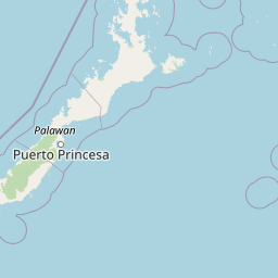
Map view of Rasa Island Wildlife Sanctuary

Use this park location map to pinpoint Rasa Island Wildlife Sanctuary in Philippines, understand its exact geographic position, and read its mapped placement within the surrounding landscape more clearly.

Pigeon | © OpenStreetMap contributors

Location context for Rasa Island Wildlife Sanctuary

Palawan
Park atlas

Compare adjacent coastal reserves and marine habitats across the Palawan archipelago

Explore Parks Near Rasa Island Wildlife Sanctuary And Protected Areas In The Surrounding Region

Browse nearby national parks and protected areas to compare regional coastal ecosystems, mangrove forests, and marine sanctuaries. Extending the geographic scope helps place isolated island refuges within a broader network of protected landscapes.
National parkPalawan
About 107 km away#1 closest

Northeast

Puerto Princesa Subterranean River National Park: Palawan's Protected Landscape Discovery

Mapped natural terrain and regional park geography.

Gain a structured understanding of Puerto Princesa Subterranean River National Park, a protected national park located in Palawan. This page details its geographic setting, contributing to a broader atlas of conservation landscapes. Explore the mapped boundaries and natural terrain that define this significant protected area, offering valuable context for regional geographic discovery.

Area
222.02 km²
Established
1999
IUCN
III
Relief
Mountain
Wildlife reservePalawan
About 141 km away#2 closest

Southwest

Ursula Island Game Refuge and Bird Sanctuary: Geography and Protected Area Overview

An isolated wildlife reserve in the Sulu Sea, Palawan

The Ursula Island Game Refuge and Bird Sanctuary functions as a vital protected landscape, containing a rare mix of lowland rainforest and dense mangrove forests. Located offshore from the Palawan coastline, this seventeen hectare sanctuary provides essential nesting grounds and ecological refuge, illustrating the complex geography of small island conservation in the tropical Sulu Sea.

Area
0.172 km²
Established
1970
Relief
Lowland
Climate
Tropical
Marine protected areaPalawan
About 155 km away#3 closest

Northeast

Port Barton Marine Park: Mapped Protected Landscape and Marine Geography in Palawan

Coastal reef ecosystems and community-managed marine sanctuary.

Port Barton Marine Park encompasses the sheltered waters and small islands of Pagdanan Bay on the western coast of Palawan. This marine protected area is defined by its complex reef systems, such as Manta Ray Reef, and a grassroots governance model that integrates local community stakeholders into the management of its vital underwater nurseries and coastal habitats.

Area
744.83 km²
Established
1998
Scope
Marine
Water
Water-dominated
Protected landscapePalawan
About 202 km away#4 closest

Northeast

Malampaya Sound Protected Landscape/Seascape: Geographic Atlas and Coastal Park Boundaries

A combined marine and terrestrial protected area in Palawan, Philippines

Gain insights into the geographic composition of Malampaya Sound Protected Landscape/Seascape. This expansive site on Palawan island encompasses sheltered bays, island chains, and mangrove-fringed shorelines. Examine the structural balance between brackish-water ecosystems, essential tidal flats, and local fishing barangays within a single managed maritime reserve.

Area
2,015.66 km²
Established
2000
Relief
Lowland
Scope
Mixed
A soft, panoramic watercolor painting depicting a coastal landscape with green rolling hills, distant mountains, and a pale shoreline.
Protected landscapePalawan
About 244 km away#5 closest

Northeast

El Nido-Taytay Managed Resource Protected Area: A Coastal Karst and Marine Landscape Atlas

Mapping the terrestrial and marine boundaries of northern Palawan.

An authoritative overview of the El Nido-Taytay Managed Resource Protected Area, detailing its extensive karst limestone islands, hidden lagoons, and diverse coastal ecosystems. This record maps the intersection of terrestrial forests and marine habitats that span the municipalities of El Nido and Taytay, providing a clear geographic context for this significant Philippine protected landscape.

Area
923.34 km²
Established
1998
Marine protected areaSabah
About 260 km away#6 closest

Southwest

Tun Mustapha Marine Park: Mapping the Protected Marine Landscapes of Northern Sabah, Malaysia

An expansive marine protected area across fifty islands

Tun Mustapha Marine Park represents a major conservation landmark off the northern coast of Borneo. This profile details the park's geographic layout, its primary island groups including Banggi and Balambangan, and its position as a critical corridor for marine megafauna and coral reef biodiversity within the Sulu-Sulawesi ecoregion.

Area
8,988 km²
Established
2016
IUCN
II
Relief
Lowland
National parkMalaysia
About 343 km away#7 closest

South

Turtle Islands National Park: Marine Protected Area and Island Geography in Malaysia

Coastal landscapes and coral reef protected zones

Explore the geographic footprint of Turtle Islands National Park, a marine-focused sanctuary in Malaysia. This protected area encompasses three islands and surrounding Sulu Sea reef ecosystems, providing critical nesting habitat for marine turtles. Learn about the island-based terrain and the marine boundaries that define this protected landscape.

Area
17.4 km²
Established
1977
Relief
Lowland
Climate
Tropical
National parkSabah
About 343 km away#8 closest

South

Turtle Islands National Park: Marine Geography and Protected Island Landscapes in Sabah

A Sulu Sea sanctuary for coral reefs and sea turtle nesting grounds.

Located north of Sandakan, Turtle Islands National Park is a key marine protected area defined by its island geography and extensive coral reef habitat. The park protects critical nesting beaches for green and hawksbill sea turtles, offering a focused look at how marine conservation intersects with tropical island terrain in the Sulu Sea. This geographic profile details the park's offshore environment and its connection to broader maritime conservation efforts in the region.

Area
17.4 km²
Established
1977
IUCN
II
Relief
Lowland

Common questions about visiting, size, designation, and location context for Rasa Island Wildlife Sanctuary

Rasa Island Wildlife Sanctuary FAQs for park facts, access, geography, and protected area context

Find quick answers about Rasa Island Wildlife Sanctuary, including protected-area facts, park geography, trail and visitor context, and how the park fits into its surrounding country and regional landscape.
MoriAtlas Explorer

Continue Your Protected Areas Search Across the Global Atlas

Deepen your exploration by continuing the structured search for national parks and protected areas worldwide. Utilize the comprehensive filtering capabilities to compare different conservation landscapes and refine your understanding of global park geography. Discover more about the distribution and characteristics of protected natural areas.

Global natural geography
