Mori Atlas logo
Nature reserveRašeliniště Kapličky

Examining the ecological mosaic and granite-based terrain within the Bohemian Forest foothills

Rašeliniště Kapličky Nature Reserve: A Detailed Geographic Atlas of the South Bohemian Peatlands

(Přírodní rezervace Rašeliniště Kapličky)

Rašeliniště Kapličky represents a critical protected upland peatland ecosystem situated on a forested plateau in the South Bohemian Region of the Czech Republic. This reserve, characterized by multi-metre peat deposits over granite bedrock, supports a complex mosaic of open bog vegetation, waterlogged spruce communities, and distinctive bog pine hybrids. By mapping the reserve's unique hydrologic features and forest structures, researchers and visitors can gain deep insight into the regional peat-forming processes across the Šumava foothills.

peatlandraised bogpeat bogbog pineSphagnumBohemian Forest

Rašeliniště Kapličky

Nature reserve

Park overview

Structured park overview, official facts, and landscape profile for Rašeliniště Kapličky

Rašeliniště Kapličky park facts, protected area profile, and essential visitor context

Review the core facts for Rašeliniště Kapličky, including designation, size, terrain, visitor scale, habitats, and operating context in one park-focused overview.

About Rašeliniště Kapličky

Rašeliniště Kapličky is a nature reserve dedicated to the protection of an unusually intact upland peatland landscape in the foothills of the Šumava (Bohemian Forest). Covering roughly 73 hectares between 890 and 920 metres elevation, it lies on a granite plateau that has favoured the development of deep peat deposits across much of the eastern two-thirds of the protected area. The combination of high humidity, acidic substrate, and relatively undisturbed hydrology has allowed several classic peatland vegetation types to persist side by side.

The geographic setting of the reserve is closely linked to the historical geopolitics of the Cold War. The peatland sits between the traces of two former villages, Kapličky and Krásná Pole, whose populations were expelled and settlements razed during the construction of the Iron Curtain. The resulting restricted access and abandonment of traditional land use helped shield the bog from large-scale drainage, ploughing or afforestation during the mid-twentieth century, although selective impacts from older melioration ditches still linger.

Ecologically, the reserve is notable for its vegetation mosaic. Open peat grassland dominated by sedges, tufted hair grass and various Sphagnum mosses covers a substantial portion of the area, while the central and western sections are marked by the low-growing, multi-stemmed stands of bog pine hybrids. Around the periphery, waterlogged spruce mires with characteristic mass occurrences of Soldanella montana add another layer of botanical value. The Lipový potok, a small stream flowing through the middle of the bog, anchors the hydrological system, supplemented by the small dystrophic pool U překopané hráze on the northern edge.

The site occupies an important place within the broader network of protected landscapes in South Bohemia. It sits inside the Vyšebrodsko Nature Park and has been identified as a candidate Site of Community Importance under the European Natura 2000 programme, due to its habitat quality and the presence of rare peatland species. For visitors and ecologists, Rašeliniště Kapličky represents one of the cleaner surviving examples of a central European upland bog in a region historically shaped by drainage and conifer plantations.

Quick facts and research context for Rašeliniště Kapličky

Rašeliniště Kapličky is a Czech nature reserve (přírodní rezervace) located in the Český Krumlov district of the South Bohemian Region. It sits at roughly 890 to 920 metres elevation on granite bedrock and encompasses about 73 hectares of upland and transitional peat bog.

The reserve was first declared a natural monument in 1992 and recategorised as a nature reserve in 1995. It lies within the Vyšebrodsko Nature Park and has been proposed as a Natura 2000 site of European importance. The mosaic of bog habitats includes Pinus rotundata / Pinus mugo hybrids, Sphagnum-rich spruce mires, open peat grassland and the small dystrophic pool known as U překopané hráze.

Protection and recognition

Documented terrestrial protection history and Natura 2000 designation records

Rašeliniště Kapličky Protection Status and International Recognition Data

Terrestrial protection status for Rašeliniště Kapličky spans formal designation records established in 1995 alongside associated Natura 2000 recognition sources. Documented conservation history outlines the administrative framework and official boundaries governing this protected area.

International recognition

Protection details

Protection scope
Terrestrial
Designated year
1995
Transboundary protection
No
Core area
0.73 km²
Park context

Deeper park guide and search-rich context for Rašeliniště Kapličky

Rašeliniště Kapličky history, landscape, wildlife, and travel context

Explore Rašeliniště Kapličky through its history, landscape character, ecosystems, wildlife, conservation priorities, cultural context, and seasonal travel timing in a structured park guide built for atlas discovery and search intent.

Why Rašeliniště Kapličky stands out

Rašeliniště Kapličky is best known for its extensive population of bog pine hybrids, the natural cross between Pinus rotundata (bog pine) and Pinus mugo (mountain pine), sometimes referred to as Pinus pseudopumilio. These low-growing pines form a distinctive dwarf forest across roughly 11 hectares of the reserve and represent one of the most valuable vegetation units within the site. Beyond the pine stands, the reserve is also recognised for its multi-metre peat deposits on granite bedrock, its Sphagnum-dominated wet spruce communities along the Lipový potok stream, and its small dystrophic peat pool. Together, these features make it an important reference site for upland peatland ecology in the Bohemian Forest region.
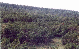
A wide angle shot of a dense, low-growing forest of pine trees typical of a bog environment, covering a gentle slope.
Peat pine vegetation within the Rašeliniště Kapličky nature reserve.

Rašeliniště Kapličky history and protected-area timeline

The peatland has a long history of careful local use. In earlier centuries, peat was extracted by hand using the traditional technique of borkování, and the meadows bordering the bog were mown or grazed. This low-intensity exploitation left the core hydrology of the system largely intact, although the impact of historical peat cutting can still be read in subtle variations of the present vegetation.

In the 1970s, surface drainage ditches were dug across parts of the bog, an intervention typical of the era's melioration campaigns. These ditches were never properly maintained, and most have since become overgrown or partly silted up, though some remain superficially functional. Their past presence remains visible in the vegetation: floating Sphagnum mats are largely absent, and overall waterlogging is somewhat lower than the topography alone would suggest.

Formal conservation protection arrived relatively late. On 27 May 1992, a 27-hectare core section of the site was declared a natural monument (přírodní památka). Three years later, in 1995, the area was reclassified as a nature reserve (přírodní rezervace) and expanded to its present extent of roughly 73 hectares. Despite its protected status, an ambiguity in the legal boundary remains: according to the relevant forestry management plan, the area attributed to the reserve is closer to 80 hectares.

Rašeliniště Kapličky landscape and geographic character

The reserve occupies a gently undulating upland plateau, characteristic of the south Bohemian flank of the Šumava range. Elevations cluster between 890 and 920 metres, high enough to support cool, acidic conditions but below the alpine lines of the highest Šumava summits. The underlying bedrock is granite, which weathers to nutrient-poor, acidic substrates ideal for peat accumulation.

The defining landform feature is, of course, the peatland itself. Across the eastern two-thirds of the reserve, peat has accumulated to depths of several metres, producing the characteristic hummocky terrain of a raised bog. To the west and along the margins, the surface becomes more dissected by the meandering channel of the Lipový potok and by relic melioration ditches, some of which still influence local water levels.

Vegetation cover reinforces the visual impression of a classic central European bog. Low, dense thickets of bog pine give way to open stretches dominated by sedges, tufted grass tussocks and bright Sphagnum carpets. On the right bank of the stream, degraded spruce stands recall older drainage attempts, while on the left bank the spruce forest remains more open and moss-rich. The small dystrophic pool U překopané hráze, with its broken dam and drowned tree trunks still standing in the water, forms a quiet scenic focal point on the northern edge of the reserve.
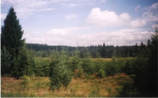
A wide view of a clearing in a forest with several small, young spruce trees planted in the foreground and a dense forest line in the background under a cloudy sky.
Young spruce plantings within the Rašeliniště Kapličky nature reserve.

Rašeliniště Kapličky ecosystems, habitats, and plant life

Rašeliniště Kapličky preserves one of the more complete vegetation mosaics of a Bohemian upland peat bog. Four main habitat types are recognised: peat-bog pine stands, open peat grassland, peat-bog spruce forest, and small areas of mesic meadow around the margins. The proportions among these habitats, and the gradients between them, give the site much of its conservation value.

The peat-bog pine, a hybrid swarm between Pinus rotundata and Pinus mugo often treated under the name Pinus pseudopumilio, anchors much of the botanical identity of the site. These shrubs typically reach only 2 to 3 metres in height across the central bog, growing taller at the margins where the genetic influence of bog pine wanes. Near the historic drainage ditches, hybrids with Pinus sylvestris appear, taller and more tree-like, with reddish upper trunks.

Open peatland vegetation covers the largest share of the reserve, dominated in wetter zones by sedges such as Carex juncella, the tufted grass Deschampsia cespitosa, Tephroseris crispus and a rich Sphagnum ground layer. In drier, more degraded patches, generalist species such as Holcus mollis, Galeopsis pubescens and Carex brizoides become more prominent, indicating past drainage impact. Around the stream, the spruce stands support masses of Soldanella montana in spring, while the small peripheral meadow hosts a comparatively species-rich mix of Polygono-Trisetion and Arrhenatherion grassland with marsh-margin species like Cirsium palustre.
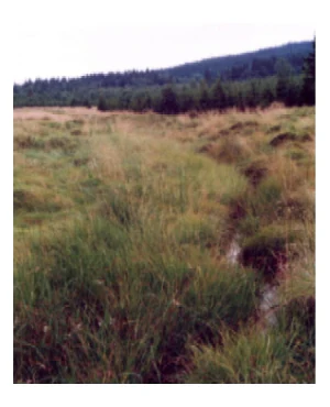
A narrow stream winds through a grassy, marshy landscape with a coniferous forest line visible in the background under an overcast sky.
Lipový potok stream flowing through the wetland ecosystem of Rašeliniště Kapličky.

Rašeliniště Kapličky wildlife and species highlights

Source content focuses primarily on the botanical and habitat dimension of the reserve rather than on animal inhabitants. Specific vertebrate species are not enumerated in detail, although the presence of rare peatland invertebrates such as the micromoth Athrips pruinosella and the grass-mining moth Elachista kilmunella is recorded among the site's notable fauna.

The mosaic of open peatland, dwarf pine thicket, waterlogged spruce forest and small dystrophic pool provides habitat for peatland-specialist invertebrates, amphibians tied to acidic standing water, and the typical bird assemblage of central European upland bogs and conifer stands. The very small size of the pool, together with its low nutrient status, limits its productivity for fish but supports the kind of invertebrate communities characteristic of dystrophic bog waters.

Rašeliniště Kapličky conservation status and protection priorities

Rašeliniště Kapličky is valued primarily as one of the better-preserved upland peat bogs of the Bohemian Forest foothills, a habitat type heavily reduced across central Europe by drainage, peat extraction and afforestation. The presence of multi-metre peat deposits, a large area of intact Sphagnum communities and the core bog-pine population gives the site genuine reference-site status for peatland conservation in the region.

The reserve has been proposed as a Site of Community Importance under the European Natura 2000 network, recognising both its habitat quality and its populations of rare species. It also falls within the Vyšebrodsko Nature Park, which provides an additional layer of landscape-scale protection.

Conservation challenges documented for the site include: lingering impacts from the 1970s melioration ditches, including partial drainage and gradual mineralisation of peat; the legacy of spruce plantings carried out in 1988 and 1989 on roughly four hectares of the southern part of the bog, where restoration drainage was even reactivated to improve planting success; the potential long-term threat of a planned pumped-storage reservoir known as Lipno III, intended to balance power output from the Temelín nuclear power plant; and the fragility of the relict bog vegetation if any renewed afforestation pressure were to emerge. Active measures under consideration include the construction of small dams across old melioration channels to raise groundwater levels and ongoing monitoring of water tables and species composition.

Rašeliniště Kapličky cultural meaning and human context

The cultural context of the reserve is unusual and poignant. The peatland lies between the sites of two former villages, Kapličky and Krásná Pole, whose inhabitants were displaced and whose buildings were demolished during the construction of the Iron Curtain in the early 1950s. The depopulation of this border strip turned what had been an area of small-scale agriculture, peat cutting and grazing into an unusually quiet and inaccessible landscape, a circumstance that, paradoxically, helped protect the bog at a critical moment in its history.

Today the reserve lies within the Vyšebrodsko Nature Park, a protected landscape area that links the site's natural heritage to the wider traditional cultural landscape of the upper Vltava river region, including the historic town of Vyšší Brod and the long-established forestry and monastery lands around it.

Top sights and standout views in Rašeliniště Kapličky

The standout features of Rašeliniště Kapličky are its multi-metre peat deposits on granite, its extensive open and forested peat bog mosaic, and in particular, the rare community of bog-pine hybrids that defines the heart of the reserve.

Best time to visit Rašeliniště Kapličky

As an ecological site rather than a developed visitor destination, the reserve is best appreciated in late spring and early summer, when flowers such as Soldanella montana brighten the spruce-mire edges and the bog vegetation is at its most visibly lush. Late spring through early autumn also offers the best conditions for observing the contrasts between open Sphagnum lawns, dwarf pine stands and waterlogged spruce forest. Winter can be harsh and accessibility depends on snow cover, though the open expanse of the bog takes on a stark and atmospheric character under snow.


Monthly climate preview

Long-term representative point measurements tracking monthly temperature ranges and precipitation patterns

Rašeliniště Kapličky Climate Normals: Annual Temperature and Precipitation Rhythm

Representative coordinates at 641 meters elevation record sustained negative winter mean temperatures alongside warmer summer peaks, accompanied by distinct monthly precipitation variations. Examining the complete twelve-month climatology profile reveals comprehensive statistical breakdowns for temperature and precipitation trends across the protected area.
Annual mean7 °C
-3 °C18 °C
Jan-3°
Feb-2°
Mar
Apr
May12°
Jun16°
Jul18°
Aug18°
Sep13°
Oct
Nov
Dec-2°
Warmest month
July

17.8 °C

Coolest month
January

-3.3 °C

Wettest month
July

3.6 mm/day

Driest month
February

1.6 mm/day

Park location guide

Geography guide, regional context, and park location map for Rašeliniště Kapličky

Rašeliniště Kapličky park geography, regions, and map view in Czechia

Understand where Rašeliniště Kapličky sits in Czechia through a broader geographic reading of the surrounding landscape, nearby location context, and its mapped position within the national park landscape.

How Rašeliniště Kapličky fits into Czechia

Czech Republic is a landlocked Central European country with a population of approximately 10.9 million people. The nation was established as an independent state on January 1, 1993, following the dissolution of Czechoslovakia. Its capital and largest city is Prague, with other major urban centers including Brno, Ostrava, Plzeň, and Liberec.

Wider geography shaping Rašeliniště Kapličky in Czechia

The Czech Republic is a landlocked country in Central Europe. It is bordered by Germany to the west, Austria to the south, Poland to the northeast, and Slovakia to the southeast. The landscape is predominantly hilly, with the territory covering 78,871 square kilometers.

Map view of Rašeliniště Kapličky

Use this park location map to pinpoint Rašeliniště Kapličky in Czechia, understand its exact geographic position, and read its mapped placement within the surrounding landscape more clearly.

Pigeon | © OpenStreetMap contributors

Location context for Rašeliniště Kapličky

Jihočeský kraj
Recorded earthquake history

Examine Recorded Earthquake History Near Rašeliniště Kapličky

Explore the documented seismic history associated with the Rašeliniště Kapličky nature reserve. This MoriAtlas collection provides a searchable catalogue of historical earthquake events, offering insights into past regional seismic activity and epicentre distribution patterns near this protected Bohemian Forest landscape.

Rašeliniště Kapličky Earthquake History

Catalogued events

4 events

Strongest magnitude

Magnitude 3.4

Most recent event

Dec 10, 1998

This history includes earthquakes recorded inside the park or within 50 km of its borders

Visual reference for bog pine habitats, peatland terrain, and protected reserve character

Rašeliniště Kapličky Photos and Landscape Scenery

Visual records reveal the distinctive upland peatland terrain and rare bog pine hybrids defining the protected reserve. Examining site photography provides clear insight into wetland habitats, Sphagnum carpets, and the wild scenery of the Bohemian Forest foothills.

A wide angle shot of a dense, low-growing forest of pine trees typical of a bog environment, covering a gentle slope.

A small, quiet pond sits in a grassy marshland with a dense dark forest bordering the horizon.

A wide view of a clearing in a forest with several small, young spruce trees planted in the foreground and a dense forest line in the background under a cloudy sky.

A narrow stream winds through a grassy, marshy landscape with a coniferous forest line visible in the background under an overcast sky.

Park atlas

Compare surrounding regional geography and connected wetland reserves

Exploring Other Parks and Protected Areas Near Rašeliniště Kapličky

Visitors exploring Rašeliniště Kapličky can browse other protected areas and regional reserves across the surrounding Bohemian Forest foothills. Examining adjacent terrain helps place local peatlands and upland plateaus into a broader conservation context.
Natural monumentJihočeský kraj
About 1.3 km away#1 closest

East

Uhlířský vrch Natural Monument: Regional Geography and Protected Forest Terrain Mapping

Mountain forest and scree woodland in the Jihočeský kraj region.

Spanning 16 hectares of northern-facing slopes near Loučovice, Uhlířský vrch stands as a vital natural monument within the Trojmezenská hornatina highlands. This record provides geographic insight into its montane habitat, elevation range, and integration into the layered conservation network of South Bohemia. Trace the boundaries and terrain features of this significant protected area in the heart of the Czech mountain landscape.

Area
0.165 km²
Established
1992
IUCN
IV
Relief
Mountain
Nature reserveJihočeský kraj
About 14 km away#2 closest

Northwest

Velké bahno Nature Reserve: Protected Wetland and Mire Geography in the Šumava Foothills

Essential conservation habitat within the Jihočeský kraj region of the Czech Republic

Velké bahno stands as a compact but vital nature reserve featuring spruce-alder swamps, wooded peatlands, and boggy clearings. Its position within the Šumava Protected Landscape Area highlights a concentration of sensitive mire habitats, protected flora, and rare species adapted to the wet, undulating paragneiss terrain of the Bohemian Forest foreland.

Area
0.915 km²
Established
1992
IUCN
IV
Relief
Upland
A horizontal watercolor painting depicting a soft, atmospheric landscape with grassy foreground vegetation, a treeline, and distant rolling hills against a pale sky.
Nature reserveJihočeský kraj
About 15 km away#3 closest

Northwest

Rašeliniště Borková Nature Reserve: Protected Peatlands in the Jihočeský kraj

Mapped wetlands and relict mire ecosystems of southern Bohemia

Located along the Lipno reservoir, Rašeliniště Borková preserves a essential fragment of the original Vltavická brázda valley landscape. The area maps a compressed, multi-zoned wetland habitat that ranges from nutrient-poor sedge mires to stable bog pine woodland, providing a necessary refuge for mire-dependent invertebrates and breeding waterbirds.

Area
0.487 km²
Established
1995
IUCN
IV
Relief
Upland
Watercolor illustration of a river flowing through a forested landscape with rolling hills in the background
National parkSouth Bohemian Region
21 km away#4 closest

Northwest

Šumava National Park: Czech Republic's Premier Forested National Park and Protected Landscape

Explore the unique glacial lakes, peat bogs, and regional geography.

Šumava National Park, situated in the South Bohemian Region of the Czech Republic, is the nation's largest protected area and a vital component of Central Europe's forest ecosystems. This entry details its expansive terrain, highlighting the significant peat bog complexes and ancient glacial lakes that define its unique landscape. Discover the park's geographic context, mapped boundaries, and its importance as a protected natural asset within the broader regional atlas.

Area
680.64 km²
Established
1991
IUCN
II
Visitors
2M annual
Watercolor illustration of a soft, rolling landscape with purple hills in the distance and pale green and pink vegetation in the foreground.
Natural monumentJihočeský kraj
About 26 km away#5 closest

North

Meandry Chvalšinského potoka Natural Monument: Mapped River Geography and Valley Terrain

Protected riparian habitat in the South Bohemian landscape

This natural monument protects a remarkably intact stretch of the Chvalšinský potok, where natural meanders, cut banks, and point bars create a living laboratory of fluvial geography. Beyond the stream itself, the site encompasses moist thistle and sedge meadows, offering a clear view into the traditional wetland ecology of the region. As a protected enclave, it maintains essential hydrological integrity within the broader landscape of the Czech countryside.

Area
0.048 km²
Established
2001
IUCN
IV
Relief
Lowland
Natural monumentJihočeský kraj
About 26 km away#6 closest

North

Výří vrch Natural Monument: Regional Geography and Limestone Habitat Mapping

Protected limestone terrain in Jihočeský kraj

Výří vrch preserves a striking limestone inselberg that rises above the regional upland forests of the Czech Republic. The site provides a critical study in how exposed calcareous geology and warm, dry microclimates support a dense, specialized collection of steppe-like flora and invertebrate species within a broader forest-dominated landscape.

Area
0.129 km²
Established
2010
IUCN
IV
Relief
Upland
Nature reserveJihočeský kraj
26 km away#7 closest

Northeast

Velký Hodonický rybník Nature Reserve: Regional Geography and Protected Wetland Atlas

Mapped aquatic habitats in the South Bohemian foothills

Situated in the Novohradské podhůří, Velký Hodonický rybník is a protected nature reserve defined by its shallow fishpond basin and specialized wetland flora. This site acts as a key element of the Natura 2000 network, preserving rare aquatic vegetation and amphibian populations within a characteristic South Bohemian landscape. The area offers a detailed view into the intersection of historical agricultural land use and contemporary environmental preservation.

Area
0.027 km²
Established
2023
IUCN
III
A watercolor painting of a rolling mountain landscape with forests, depicted in varying tones of green, orange, and purple, set against a white background.
Nature reserveJihočeský kraj
About 33 km away#8 closest

North

Ptačí stěna Nature Reserve: Mapped Geographic Profile of South Bohemian Protected Forests

Granulite cliff landforms and submontane beech forest mapping.

Ptačí stěna Nature Reserve occupies a steep southwestern slope in the Blanský les, defined by a linear granulite frost-riven cliff and a vast talus field of boulders up to three meters across. This protected area showcases the interplay between mature 150-year-old beech woodlands and rugged, cool microhabitats that support unique species. The site serves as a vital example of layered forest and rock conservation in South Bohemia.

Area
0.205 km²
Established
1996
IUCN
IV
Relief
Mountain

Common questions about visiting, size, designation, and location context for Rašeliniště Kapličky

Rašeliniště Kapličky FAQs for park facts, access, geography, and protected area context

Find quick answers about Rašeliniště Kapličky, including protected-area facts, park geography, trail and visitor context, and how the park fits into its surrounding country and regional landscape.
MoriAtlas Explorer

Continue Your Protected Areas Search Across the Global Atlas

Deepen your exploration by continuing the structured search for national parks and protected areas worldwide. Utilize the comprehensive filtering capabilities to compare different conservation landscapes and refine your understanding of global park geography. Discover more about the distribution and characteristics of protected natural areas.

Global natural geography