Mori Atlas logo
Wildlife reserveRefugio de Vida Silvestre Manglares El Morro

A vital mangrove forest system and marine sanctuary situated at the mouth of Ecuador's Gulf of Guayaquil

Refugio de Vida Silvestre Manglares El Morro: Mapped Geography and Coastal Protected Area Identity

Refugio de Vida Silvestre Manglares El Morro constitutes a primary coastal protected area in the Guayas Province of Ecuador, defined by an expansive matrix of mangrove forests and tidal estuaries. Positioned at the entrance of the Gulf of Guayaquil, the refuge features a unique water-dominated terrain where Pacific Ocean currents shape both the marine habitat and the surrounding ecological landscape. This protected territory provides critical sanctuary for various marine species and seabirds, offering a distinct example of tropical coastal wetland geography within the national system.

mangrovescoastal wetlandmarine wildlifeseabirdsbottlenose dolphinssea lions

Refugio de Vida Silvestre Manglares El Morro

Wildlife reserve

Park overview

Structured park overview, official facts, and landscape profile for Manglares El Morro Wildlife Refuge

Manglares El Morro Wildlife Refuge park facts, protected area profile, and essential visitor context

Review the core facts for Manglares El Morro Wildlife Refuge, including designation, size, terrain, visitor scale, habitats, and operating context in one park-focused overview.

About Manglares El Morro Wildlife Refuge

Manglares El Morro is a coastal wetland reserve that anchors the southern edge of Ecuador's Pacific mangrove belt. Formally created in 2007 and integrated into Ecuador's National System of Protected Areas, the refuge protects more than ten thousand hectares of mangrove forests, tidal channels, and emerging rock formations known locally as farallones. It lies at the transition zone between the open Pacific Ocean and the Gulf of Guayaquil, an estuarine system of considerable ecological importance on the South American coast.

The refuge is located in the Guayas Province, within the jurisdiction of the Guayaquil canton, and is reachable in roughly an hour from the city of Guayaquil and just minutes from the coastal town of General Villamil, known as Playas. This coastal setting, combined with the influence of marine currents from the Pacific, shapes a habitat system that feels distinctly different from inland reserves. The vegetation is dominated by low mangrove forests that weave between estuaries and natural channels, while small islands rise above the surrounding waters in formations known as farallones.

Ecologically, Manglares El Morro is recognized for its role as a refuge for marine and coastal wildlife. Seabirds and aquatic birds use the area for nesting, resting, and seasonal停留, while bottlenose dolphins are present throughout the year. During colder ocean periods, marine mammals such as sea lions arrive in the refuge, and sea turtles pass through its waters as part of their migratory routes. This intersection of resident and migratory wildlife gives the refuge a dynamic and ever-changing ecological character.

Beyond its conservation role, Manglares El Morro has become a focal point for community-based ecotourism. Local communities in Puerto El Morro, Posorja, and Isla Puná have built livelihoods around guided visits into the mangroves, and the refuge now welcomes tens of thousands of visitors annually, making it the most visited protected area associated with Guayaquil. This blend of ecological significance and community engagement defines the identity of Manglares El Morro as both a conservation stronghold and a working coastal landscape.

Quick facts and research context for Manglares El Morro Wildlife Refuge

Manglares El Morro is a wildlife refuge in the Ecuadorian coastal province of Guayas, situated at the entrance of the Gulf of Guayaquil. Created on September 13, 2007, the refuge covers roughly 10,130 hectares of mangrove wetlands, tidal channels, and emerging rocky islands. It is part of Ecuador's National System of Protected Areas and is administered by Fundación Natura. The refuge stands out as the most visited protected area in the Guayaquil region, supporting both conservation and community-based ecotourism.

Protection and recognition

Review documented protection scope and international recognition records for Refugio de Vida Silvestre Manglares El Morro.

Refugio de Vida Silvestre Manglares El Morro Protection Status and Designated History

Examine the documented protection status, mixed management scope, and 2007 designation history recorded for Refugio de Vida Silvestre Manglares El Morro. Verified administrative records outline the official conservation framework without assuming external international recognitions.

Protection details

Protection scope
Mixed
Designated year
2007
Transboundary protection
No
Park context

Deeper park guide and search-rich context for Manglares El Morro Wildlife Refuge

Manglares El Morro Wildlife Refuge history, landscape, wildlife, and travel context

Explore Manglares El Morro Wildlife Refuge through its history, landscape character, ecosystems, wildlife, conservation priorities, cultural context, and seasonal travel timing in a structured park guide built for atlas discovery and search intent.

Why Manglares El Morro Wildlife Refuge stands out

Manglares El Morro is best known for its extensive mangrove forests, tidal estuaries, and the marine wildlife that depends on them. The refuge is a major nesting and resting site for seabirds and aquatic birds, a year-round habitat for bottlenose dolphins, and a seasonal refuge for sea lions arriving during cooler ocean conditions. Its location at the entrance of the Gulf of Guayaquil, where Pacific currents directly influence the climate, gives the refuge an ecological profile distinct from Ecuador's interior protected areas. The combination of mangrove forests, brackish channels, and emerging islands makes it a defining example of Ecuador's tropical Pacific coastal ecosystems.

Manglares El Morro Wildlife Refuge history and protected-area timeline

Manglares El Morro was formally established as a protected area on September 13, 2007, through Interministerial Agreement No. 0266, published in Official Record No. 180 on September 28, 2007. The refuge was integrated into Ecuador's National System of Protected Areas as a Wildlife Refuge, a designation aimed at safeguarding critical habitat for marine and coastal wildlife.

Its creation responded to the ecological importance of the mangrove forests and tidal ecosystems located at the entrance of the Gulf of Guayaquil. Over time, the refuge has also become closely tied to the surrounding coastal communities of Puerto El Morro, Posorja, and Isla Puná, where ecotourism has grown into a significant economic activity supported by the protected area. A proposal has emerged to expand its surface considerably, reflecting ongoing recognition of the refuge's ecological and community value.

Manglares El Morro Wildlife Refuge landscape and geographic character

The landscape of Manglares El Morro is defined by the meeting of tropical mangrove forests and the tidal waters of the Gulf of Guayaquil. Low mangrove forests form a continuous belt along the shoreline, intersected by a network of natural channels and estuaries that fill and drain with the tides. These waterways shape the internal geography of the refuge and give it a labyrinthine, water-dominated character.

Within this mangrove matrix, small rocky formations known as farallones rise above the water, creating islands in various stages of formation. The terrain is essentially flat, ranging from sea level to only a few tens of meters in elevation, and the climate is directly modulated by marine currents arriving from the Pacific Ocean. The result is a coastal landscape where land and water intermix across an expansive, navigable wetland system.

Manglares El Morro Wildlife Refuge ecosystems, habitats, and plant life

The refuge's ecosystem is built around mangroves, a habitat type that supports exceptionally high biological productivity along tropical Pacific coastlines. The mangrove forests of Manglares El Morro function as a transition between freshwater, brackish, and marine environments, creating a mosaic of conditions that supports a wide range of species.

Because the refuge sits at the entrance of the Gulf of Guayaquil, its ecological dynamics are strongly shaped by ocean currents, salinity patterns, and tidal exchange. This positioning gives the refuge a distinct character compared with Ecuador's interior protected areas. The combination of mangrove canopy, tidal channels, and emerging rocky islands creates a layered habitat complex that supports both resident and migratory species across multiple ecological niches.

Manglares El Morro Wildlife Refuge wildlife and species highlights

Wildlife is one of the defining elements of Manglares El Morro. The refuge serves as a nesting, resting, and reproductive site for a variety of seabirds and aquatic birds, which rely on the mangrove canopy and rocky outcrops for shelter and breeding habitat. Resident bottlenose dolphins are a regular presence in the refuge's waters, contributing to its identity as a marine mammal habitat.

During cooler ocean periods, marine mammals such as sea lions arrive in the area, taking advantage of the productive waters of the Gulf of Guayaquil. Sea turtles also pass through the refuge as part of their broader migratory routes along the Pacific coast. The combination of year-round resident species and seasonal visitors gives the refuge a continuously shifting wildlife profile, with different species becoming more visible depending on ocean conditions and season.

Manglares El Morro Wildlife Refuge conservation status and protection priorities

Manglares El Morro holds significant conservation value as a representative example of Ecuador's Pacific mangrove ecosystems. Mangroves of this kind provide essential ecological services, including shoreline stabilization, nutrient cycling, nursery habitat for marine species, and carbon storage, making their protection strategically important beyond their immediate biodiversity value.

As part of Ecuador's National System of Protected Areas and managed in coordination with Fundación Natura, the refuge contributes to regional efforts to maintain ecological connectivity along the Gulf of Guayaquil. Its recognition under IUCN Category Ib reflects its role as a managed wildlife sanctuary where natural processes and active conservation combine to protect sensitive coastal species and habitats. The proposed expansion of its surface further underscores the growing recognition of its conservation importance.

Manglares El Morro Wildlife Refuge cultural meaning and human context

Manglares El Morro is closely tied to the identity and livelihoods of the surrounding coastal communities. Puerto El Morro, Posorja, and Isla Puná are the principal human settlements linked to the refuge, and around two hundred local families derive part of their income from ecotourism activities based in the protected area. This connection between local communities and the mangrove ecosystem has shaped how the refuge is managed and experienced.

Local celebrations such as the Fiestas del Morro and the Fiesta de Santa Narcisa de Jesús reflect the cultural traditions of the area and reinforce the role of the refuge as a shared natural and cultural heritage space. The interplay between traditional coastal life and modern conservation-based tourism is a defining part of the refuge's broader context.

Top sights and standout views in Manglares El Morro Wildlife Refuge

Manglares El Morro stands out for its expansive mangrove forests, its dynamic tidal channel system, and its rich marine wildlife. The refuge combines ecological importance with one of the most active community-based ecotourism models along Ecuador's coast, drawing visitors from Guayaquil and beyond. Its position at the entrance of the Gulf of Guayaquil gives it a distinctive ecological identity shaped by Pacific Ocean currents, and its accessibility makes it a flagship protected area within the Guayaquil region.

Best time to visit Manglares El Morro Wildlife Refuge

The climate and ecological character of Manglares El Morro are shaped by Pacific Ocean currents, which influence both weather and wildlife patterns throughout the year. Cooler ocean periods tend to bring additional marine mammals such as sea lions into refuge waters, while seabird nesting and resting activity shifts with seasonal cycles. Visiting during periods of stable weather allows for clearer navigation through the mangrove channels and a fuller experience of the refuge's wildlife. The refuge's accessibility from Guayaquil and from nearby coastal towns makes it feasible to visit across much of the year, though conditions on the water vary with tides and ocean conditions.

Monthly climate preview

Long-term representative coordinate records detailing measured temperature and monthly precipitation

Refugio de Vida Silvestre Manglares El Morro Climate Normals and Annual Weather Patterns

Representative coordinates for Refugio de Vida Silvestre Manglares El Morro record consistent mean annual temperatures alongside distinct seasonal shifts in monthly precipitation. Examining the complete twelve-month climatology profile reveals precise long-term trends for temperature ranges and rainfall averages.
Annual mean26 °C
25 °C26 °C
Jan26°
Feb26°
Mar26°
Apr26°
May26°
Jun26°
Jul26°
Aug26°
Sep25°
Oct25°
Nov25°
Dec26°
Warmest month
January

26.3 °C

Coolest month
November

25.4 °C

Wettest month
February

6.8 mm/day

Driest month
August

0.2 mm/day

Park location guide

Geography guide, regional context, and park location map for Manglares El Morro Wildlife Refuge

Manglares El Morro Wildlife Refuge park geography, regions, and map view in Ecuador

Understand where Manglares El Morro Wildlife Refuge sits in Ecuador through a broader geographic reading of the surrounding landscape, nearby location context, and its mapped position within the national park landscape.

How Manglares El Morro Wildlife Refuge fits into Ecuador

Ecuador is a presidential republic located in northwestern South America, with Quito as its capital and Guayaquil as its largest city. The country spans 283,561 km² and encompasses the Galápagos Islands, a volcanic archipelago famous for unique wildlife that helped shape Darwin's theory of evolution. Ecuador is a plurinational state with Spanish as the official language, though Kichwa and Shuar are recognized for indigenous peoples.

Wider geography shaping Manglares El Morro Wildlife Refuge in Ecuador

Ecuador is located in northwestern South America along the Pacific coast. It shares borders with Colombia to the north and Peru to the east and south. The country includes the Galápagos Islands, a volcanic archipelago in the Pacific Ocean approximately 1,000 km west of the mainland. The territory encompasses diverse terrain including the Amazon rainforest in the east, the Andean highlands in the center, and coastal plains along the Pacific.

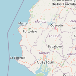
Map view of Manglares El Morro Wildlife Refuge

Use this park location map to pinpoint Manglares El Morro Wildlife Refuge in Ecuador, understand its exact geographic position, and read its mapped placement within the surrounding landscape more clearly.

Pigeon | © OpenStreetMap contributors

Location context for Manglares El Morro Wildlife Refuge

Guayas
Recorded earthquake history

Explore Historical Earthquake Records Near Manglares El Morro

Access a detailed catalogue of seismic events linked by geography to Refugio de Vida Silvestre Manglares El Morro. This MoriAtlas collection provides transparent access to historical data points, including epicenter distance and magnitude, for anyone interested in the regional seismic activity profile of this coastal protected area.

Manglares El Morro Earthquake History

Catalogued events

91 events

Strongest magnitude

Magnitude 6.8

Most recent event

Apr 4, 2026

This history includes earthquakes recorded inside the park or within 50 km of its borders

Park atlas

Compare adjacent marine reserves and regional wetland geography across southwestern Ecuador

Parks Near Refugio de Vida Silvestre Manglares El Morro and Coastal Protected Landscapes

Browsing other protected areas near Refugio de Vida Silvestre Manglares El Morro reveals broader coastal wetland ecosystems and tidal habitats across the Guayas Province. Comparing adjacent regional geography helps connect tropical mangrove terrain with wider marine conservation networks.
A pale, soft watercolor painting showing a stylized, rolling landscape with light green, pink, and yellow hues representing hills and trees.
Nature reserveGuayas Province
34 km away#1 closest

East

Reserva ecológica Manglares Churute: Mapping a Coastal Nature Reserve in Guayas Province

An ecological mosaic of mangrove forests, estuaries, and forested ridges.

Spanning from the inner Gulf of Guayaquil into the Churute hill range, Reserva ecológica Manglares Churute acts as an essential protected area within Ecuador. The region contains one of the country's most significant mangrove complexes, complemented by freshwater lagoons and unique fog-affected forest summits that support diverse wildlife populations and endemic vegetation.

Area
471.74 km²
Established
1979
IUCN
Ia
Relief
Mixed relief
Wildlife reserveGuayas
About 43 km away#2 closest

Northeast

Reserva de producción de fauna Manglares El Salado: Coastal Geography and Protected Lands

A mangrove-dominated wildlife reserve in Guayas, Ecuador.

Analyze the protected landscape of Reserva de producción de fauna Manglares El Salado, which spans extensive mangrove forests and estuarine waters within the Guayas province. This wildlife reserve showcases a unique transition between intertidal mangrove zones, salt flats, and remnants of tropical dry forest, providing essential habitat context for the Gulf of Guayaquil coastal region.

Area
53.09 km²
Established
2002
IUCN
VI
Relief
Lowland
A horizontal watercolor painting showing a stylized forest landscape with soft pastel green, yellow, and pink hues representing trees and rolling hills.
Protected areaGuayas
About 48 km away#3 closest

Northeast

Bosque Protector Cerro Blanco: Protected Area and Tropical Dry Forest Geography in Guayas

Mapped terrain of the Chongon-Colonche mountain range

Bosque Protector Cerro Blanco functions as a major conservation site in coastal Ecuador, protecting rare Tumbesian forest ecosystems within the Guayas province. The reserve features diverse topography of ridges and valleys, serving as a critical buffer for regional endemic species and offering a unique look at seasonally dry forest landscapes near Guayaquil.

Area
60.78 km²
Established
1992
Visitors
12K annual
Relief
Upland
Nature reserveGuayas
About 53 km away#4 closest

Northeast

Bosque Protector La Prosperina Nature Reserve and Coastal Ecuador Forest Geography

Protected dry forest habitat and regional geographic terrain

Bosque Protector La Prosperina represents a critical survival of Ecuador's equatorial dry forest within the Guayas province. This nature reserve offers deep insight into seasonal ravine networks, drought-adapted vegetation, and the structural dynamics of fragmented coastal landscapes near Guayaquil.

Area
2.424 km²
Established
1994
Relief
Upland
Climate
Tropical
Nature reserveWestern Sahara
76 km away#5 closest

South

Reserva ecológica Arenillas Nature Reserve: Geographic Landscape and Protected Area Context

Examining dry forest ecosystems and coastal habitat boundaries

Reserva ecológica Arenillas is a significant nature reserve, distinguished by its intact dry forest and coastal mangrove systems. The area serves as a key benchmark for regional conservation efforts, offering a detailed look at the interface between tropical shrubland and maritime environments through a protected geographic lens.

Area
131.65 km²
Established
2001
Relief
Lowland
Climate
Tropical
Watercolor painting of a mountain landscape with a lake, rolling hills, and coniferous trees in soft green and yellow tones.
National parkAzuay
86 km away#6 closest

East

Parque nacional Cajas: Mapping the Glacial Lakes and Paramo of the Ecuadorian Andes

Geographic analysis of high-elevation protected lands

Parque nacional Cajas encompasses a rugged, glacial-sculpted plateau characterized by cushion vegetation, boggy wetlands, and frequent fog. This protected area offers deep insight into the highland Andean geography of Azuay, where water bodies and mountain ridges intersect to form an essential ecological and cultural corridor for the region.

Area
293.89 km²
Established
1977
IUCN
II
Visitors
53K annual
A horizontal watercolor painting showing a pale green and soft pink landscape with rolling hills in the background, a flat expanse of light green vegetation in the midground, and a suggestion of water in the foreground.
Marine protected areaSanta Elena
About 92 km away#7 closest

Northwest

Reserva Marina El Pelado: Coastal Marine Protected Area and Underwater Reef Geography

Oceanic convergence zone within the Santa Elena province

Reserva Marina El Pelado features a distinct maritime landscape defined by thirteen submarine shoals, octocoral forests, and coastal mangrove systems. Located within the Santa Elena province, this protected area serves as an essential biological laboratory where tropical and temperate current systems collide, shaping a complex mosaic of rocky reefs and diverse marine habitats.

Area
131.55 km²
Established
2012
IUCN
VI
Relief
Lowland
Wildlife reserveSanta Elena
About 94 km away#8 closest

Northwest

Reserva de Producción de Fauna Marino Costero Puntilla Santa Elena Protected Area Map

Coastal marine geography and Pacific wildlife habitat exploration.

Investigate the marine-coastal expanse of the Reserva de Producción de Fauna Marino Costero Puntilla Santa Elena. This protected area encompasses diverse Pacific habitats, from arid shoreline vegetation to vast ocean sectors, serving as a critical environment for marine mammal migration and conservation in Santa Elena.

Area
524.34 km²
Relief
Lowland
Climate
Arid
Access
Easy access

Common questions about visiting, size, designation, and location context for Manglares El Morro Wildlife Refuge

Manglares El Morro Wildlife Refuge FAQs for park facts, access, geography, and protected area context

Find quick answers about Manglares El Morro Wildlife Refuge, including protected-area facts, park geography, trail and visitor context, and how the park fits into its surrounding country and regional landscape.
MoriAtlas Explorer

Continue Your Protected Areas Search Across the Global Atlas

Deepen your exploration by continuing the structured search for national parks and protected areas worldwide. Utilize the comprehensive filtering capabilities to compare different conservation landscapes and refine your understanding of global park geography. Discover more about the distribution and characteristics of protected natural areas.

Global natural geography