Mori Atlas logo
Nature reserveRéserve forestière de Diécké

A dense evergreen forest sanctuary defined by hilly terrain and river-fed swampy lowlands.

Réserve forestière de Diécké: Mapping the Protected Lowland Rainforest of Southeastern Guinea

Spanning approximately 64,000 hectares in the Préfecture de Yomou, the Réserve forestière de Diécké stands as a vital remnant of West African humid forest. This protected area features an undulating landscape of evergreen rainforest, with elevations reaching up to 595 meters. The interior geography is defined by a dense canopy, a network of watercourses including the Nyé and Gbin rivers, and a complex management structure that preserves primary growth zones against regional environmental pressures.

lowland rainforestevergreen foresttropical forest reserveforest conservationclosed canopy forestriparian forest

Réserve forestière de Diécké

Nature reserve

Park overview

Structured park overview, official facts, and landscape profile for Réserve forestière de Diécké

Réserve forestière de Diécké park facts, protected area profile, and essential visitor context

Review the core facts for Réserve forestière de Diécké, including designation, size, terrain, visitor scale, habitats, and operating context in one park-focused overview.

About Réserve forestière de Diécké

The Réserve forestière de Diécké lies in the forested southeastern part of Guinea, within the Yomou Prefecture and near the sub-prefecture of Diécké. Its location, about 150 kilometers west of Bossou, places it in a transitional zone between the dense forests of the Upper Guinean region and the patchwork of farmland, secondary forest, and small settlements that dominate the surrounding landscape.

At roughly 64,000 hectares, the reserve is sizable by West African forest reserve standards. It spans a gently hilly to moderately broken topography ranging from 400 to 595 meters in elevation. The vegetation is dominated by closed-canopy lowland rainforest with characteristics typical of evergreen tropical forest in the region: a relatively continuous upper canopy, varied understory structure, and a mix of primary and secondary growth. About seventy percent of the surface area is classified as primary and secondary dense forest. The remainder consists of semi-dense forest, non-forested areas, and fallow land that reflects past human use.

A defining feature of Diécké is its zonal management history. During the early and mid-1990s, a project delineated the reserve into three distinct zones. A core protection zone of around 14,762 hectares, roughly a quarter of the reserve, was largely protected from past logging and is kept off-limits to timber harvesting and extraction. A surrounding sustainable use zone allows continued timber exploitation under regulated conditions, with forest conditions ranging from lightly to severely degraded and including areas that still appear to be primary forest, especially in remote marécage and steep hill areas. An improvement zone covers most of the periphery of the reserve and is focused on natural forest that is degraded but still capable of regeneration.

The reserve is also shaped by its hydrology. Two principal rivers, the Nyé in the southwest and the Gbin in the southeast, cross the forest, along with three smaller watercourses. These rivers and the swampy terrain they create contribute to the humid microclimate of the reserve and increase the difficulty of access in many areas, which has helped preserve pockets of less-disturbed forest. In broader context, Diécké is one of the important remaining lowland forest blocks in Guinea and contributes to the wider network of protected natural areas in the country.

Quick facts and research context for Réserve forestière de Diécké

The Réserve forestière de Diécké is located in the Yomou Prefecture of southeastern Guinea, within the broader forest region of West Africa. With an extent of about 64,000 hectares, it is one of the larger classified forest reserves in the country. Its elevation ranges between 400 and 595 meters, and its vegetation is dominated by dense, evergreen lowland rainforest with a closed canopy. About seventy percent of the reserve consists of primary and secondary dense forest, complemented by semi-dense forest, open non-forested areas, and fallow land. The reserve is crossed by the Nyé and Gbin rivers along with several smaller watercourses, and it was the subject of a 1991 to 1996 management project that divided it into three zones with different levels of protection.

Protection and recognition

Explore documented terrestrial protection metrics and official conservation data.

Réserve forestière de Diécké Protection Status and Designated Area Record

Terrestrial protection status records for Réserve forestière de Diécké outline documented management scopes without relying on unverified international designations. Structured conservation metrics provide transparent access to official protected area data for geographical research.

Protection details

Protection scope
Terrestrial
Transboundary protection
No
WDPA ID
29484
Core area
147.62 km²
Park context

Deeper park guide and search-rich context for Réserve forestière de Diécké

Réserve forestière de Diécké history, landscape, wildlife, and travel context

Explore Réserve forestière de Diécké through its history, landscape character, ecosystems, wildlife, conservation priorities, cultural context, and seasonal travel timing in a structured park guide built for atlas discovery and search intent.

Why Réserve forestière de Diécké stands out

Diécké is best known for its extensive tract of lowland evergreen rainforest in southeastern Guinea, and for being one of the country's most clearly zoned forest reserves. The reserve stands out for its combination of remaining primary growth, rugged hilly terrain, swampy lowlands, and a management scheme that separates a strict core protection zone from areas of sustainable timber use and forest improvement. It holds significance as one of the larger blocks of West African humid forest that has been formally classified for conservation and that still contains a substantial proportion of undisturbed canopy, despite pressure from logging, agriculture, and shifting cultivation in surrounding areas.

Réserve forestière de Diécké history and protected-area timeline

Although the precise legal establishment date of the Réserve forestière de Diécké is not detailed in the available sources, the reserve's history is closely linked to the management era of the early 1990s, when a dedicated project ran from 1991 to 1996 to reorganize the forest into differentiated management zones.

That project formalized three categories of land within the reserve. It recognized that the central portion of the forest had historically been less affected by logging and designated it as a core protection zone in which timber extraction and exploitation would be prohibited. It established a surrounding zone where wood exploitation would remain permitted under controlled conditions, reflecting both the forest's economic importance and the variable condition of the standing timber. Finally, it identified a broad peripheral improvement zone where degraded natural forest would be the focus of longer-term recovery efforts.

The resulting zonation has shaped how the reserve has been understood and managed since: as a forest block with a strictly protected interior, a working forest around it, and an outer buffer where gradual improvement and regeneration are the priority. This layered approach distinguished Diécké from many other forest reserves in the region and made it the subject of external documentation referenced through the World Database on Protected Areas.

Réserve forestière de Diécké landscape and geographic character

The landscape of Diécké is defined by low to moderate hills covered by a continuous expanse of humid lowland forest. Elevations within the reserve stretch from about 400 meters to 595 meters, producing an undulating terrain that includes plateau-like sections, steeper hill slopes, and flatter valley bottoms. The topography, combined with the dense vegetation, makes much of the interior physically difficult to traverse.

Dominating the terrain is a closed canopy of evergreen rainforest, a hallmark of West African lowland forest. The upper strata form a relatively continuous cover, while the lower strata are more variable, with open stretches alternating with denser thickets and patches of secondary regrowth. Where the canopy has been disturbed or removed, semi-dense formations, open zones, and fallow areas have taken their place, especially toward the periphery of the reserve.

Hydrology shapes the lower portions of the landscape. The Nyé and Gbin rivers, together with three additional watercourses, cut through the forest. Their valleys create zones of swamp and standing water that shift the vegetation toward more hydrophilic plant communities and that, in combination with the steep surrounding hills, deepen the sense of a remote and fragmented forest interior. Together these features make Diécké a landscape of unbroken forest, scattered swampy lowlands, and forested ridges.

Réserve forestière de Diécké ecosystems, habitats, and plant life

The ecological identity of Diécké is rooted in West African evergreen lowland rainforest. The reserve is dominated by dense forest types, with around seventy percent of its area made up of primary and secondary forest formations that together maintain largely closed canopies.

These dense forests are complemented by semi-dense formations distributed mainly toward the edges of the reserve, by non-forested gaps that interrupt the canopy, and by areas of fallow land that reflect past human activity. The diverse canopy and understory structure creates varied light conditions and microhabitats, from open understory in parts of the core zone to dense, tangled vegetation along rivers, in swamps, and on steep slopes.

The presence of two main rivers and three additional watercourses, combined with the swampy depressions they create, supports consistently humid conditions across much of the reserve. This hydrological network is a defining ecological feature, sustaining the moisture-dependent evergreen forest and maintaining more specialized wet environments within an otherwise predominantly terrestrial forest block.

Réserve forestière de Diécké wildlife and species highlights

The available sources do not provide detailed species lists for the Réserve forestière de Diécké. However, the reserve's large extent of dense, evergreen lowland rainforest, its swampy riparian corridors, and its mixture of primary and secondary growth indicate the kind of habitat that in West Africa typically supports forest-dependent mammals, a diverse bird community, and a rich assemblage of forest insects, amphibians, and reptiles.

The combination of intact canopy in the core zone, heavily vegetated river valleys, and more disturbed edge habitats means that the reserve likely supports a range of species tied to undisturbed interior forest as well as those able to use more open or regenerating habitats.

Réserve forestière de Diécké conservation status and protection priorities

Diécké is significant from a conservation perspective as one of the larger formally recognized forest reserves in Guinea and as one of the few in the region whose management structure explicitly distinguishes a strict protection zone from surrounding areas of sustainable use and forest improvement.

The core protection zone of roughly 14,762 hectares has historically been the least disturbed by logging and is closed to timber extraction and resource exploitation, providing a refuge of largely intact canopy. The sustainable use zone acknowledges the economic importance of timber in the region but confines extraction to a regulated area, while the improvement zone addresses degraded peripheral forest. This tiered approach gives the reserve a more structured conservation function than many surrounding forest areas.

In the broader Guinean and West African context, the reserve represents a meaningful remnant of lowland evergreen rainforest in a landscape where forest cover continues to be reduced by agricultural expansion, logging, and shifting cultivation. Its inclusion in international databases of protected areas reflects recognition of its value as a forest block of regional conservation interest.

Réserve forestière de Diécké cultural meaning and human context

The Réserve forestière de Diécké is embedded in a cultural landscape shaped by rural forest communities, where smallholder agriculture, shifting cultivation, and reliance on forest products have long been part of local livelihoods. The presence of fallow land, semi-dense forest, and non-forested pockets within the reserve's perimeter reflects this history of human interaction with the forest.

The reserve's location in the Yomou Prefecture, near the sub-prefecture of Diécké, places it within an area of southeastern Guinea where villages and forest land have long coexisted. The zonation of the reserve into protection, sustainable use, and improvement areas can be read as an attempt to balance local resource use with the preservation of denser forest stands, though specific cultural or traditional land-use practices tied to particular communities are not detailed in the available sources.

Top sights and standout views in Réserve forestière de Diécké

The most distinctive aspect of Diécké is its sheer scale as a lowland evergreen forest reserve, with roughly 64,000 hectares of mostly continuous rainforest rising between 400 and 595 meters above sea level. About seventy percent of the reserve remains primary or secondary dense forest, a substantial proportion in a region where such stands have become increasingly rare.

Equally notable is the reserve's tri-zonal management structure, established through a project that ran from 1991 to 1996. A strict core protection zone preserves the least-disturbed canopy, a surrounding sustainable use zone allows regulated timber activity, and an outer improvement zone targets degraded peripheral forest. The Nyé and Gbin rivers, together with three smaller watercourses, further shape the reserve's character, feeding swampy lowlands and steep forested hills that keep much of the interior difficult to access and help protect its most intact stands.

Best time to visit Réserve forestière de Diécké

The available sources do not contain specific seasonal visitor information for the Réserve forestière de Diécké. As a lowland evergreen rainforest reserve, its character is influenced by the wet and dry seasons typical of southeastern Guinea, with rain likely enhancing the lushness and humidity of the forest, swampy conditions in the river valleys, and the overall green appearance of the canopy. Drier periods would generally make internal terrain easier to traverse. Any season-sensitive planning would depend on the specific goals of a visit, such as observing forest conditions in full leaf versus accessing interior terrain more easily.

Monthly climate preview

Long-term representative point measurements of annual temperature and precipitation spread

Réserve forestière de Diécké climate normals and monthly temperature rhythm

Representative coordinate records show measured shifts in average monthly temperatures and precipitation rates across the protected area. Examining the full twelve-month dataset clarifies long-term meteorological patterns at the sampled elevation.
Annual mean24 °C
23 °C26 °C
Jan24°
Feb26°
Mar26°
Apr26°
May25°
Jun24°
Jul23°
Aug23°
Sep23°
Oct24°
Nov24°
Dec24°
Warmest month
March

26.3 °C

Coolest month
August

22.7 °C

Wettest month
September

9.9 mm/day

Driest month
January

0.5 mm/day

Park location guide

Geography guide, regional context, and park location map for Réserve forestière de Diécké

Réserve forestière de Diécké park geography, regions, and map view in Guinea

Understand where Réserve forestière de Diécké sits in Guinea through a broader geographic reading of the surrounding landscape, nearby location context, and its mapped position within the national park landscape.

How Réserve forestière de Diécké fits into Guinea

Guinea is a West African country with a population of approximately 14 million people. The country achieved independence from France in 1958 and is known for its diverse geography ranging from coastal lowlands to highland plateaus. Conakry serves as both the capital and largest city. Guinea is a member of the United Nations, ECOWAS, the African Union, and La Francophonie.

Wider geography shaping Réserve forestière de Diécké in Guinea

Guinea is located on the West African Atlantic coast, bordered by Guinea-Bissau to the northwest, Senegal to the north, Mali to the northeast, Ivory Coast to the southeast, and Sierra Leone and Liberia to the south. The country is divided into four geographic regions: Maritime Guinea along the Atlantic coast, the Fouta Djallon highlands in Middle Guinea, the Upper Guinea savanna in the northeast, and the forested Guinea region in the southeast.

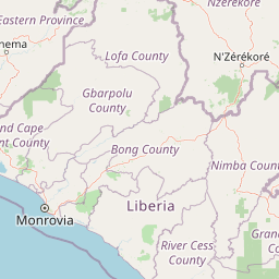
Map view of Réserve forestière de Diécké

Use this park location map to pinpoint Réserve forestière de Diécké in Guinea, understand its exact geographic position, and read its mapped placement within the surrounding landscape more clearly.

Pigeon | © OpenStreetMap contributors

Location context for Réserve forestière de Diécké

Préfecture de Yomou
Park atlas

Compare surrounding lowland forest reserves and regional conservation landscapes

Parks Near Réserve forestière de Diécké and Regional Protected Areas

Browsing other protected areas near Réserve forestière de Diécké reveals broader regional forest networks and connected tropical ecosystems. Extending the geographic review helps map similar lowland habitats and adjacent conservation zones across southeastern Guinea.
Protected areaNimba County
About 53 km away#1 closest

East

Nimba National Forest: Protected Mountain Landscape & Bird Area in Nimba County

Explore mapped boundaries and regional geographic context.

Nimba National Forest, a protected area of approximately 187 square kilometers, is defined by its mountainous terrain in Nimba County, Liberia. Situated at the tri-border region with Guinea and Ivory Coast, this forest is recognized for its importance as a habitat for diverse bird species and its role in regional conservation efforts. Discover its mapped landscape, its position within the Nimba Range, and its ecological significance within West Africa's protected natural areas.

Area
187 km²
IUCN
VI
Access
Access unknown
Scope
Terrestrial
National parkNimba County
About 82 km away#2 closest

Southeast

Gio National Forest National Park: A Protected Landscape in Nimba County

Mapping the geographic boundaries and regional context of Gio National Forest.

Gio National Forest National Park serves as a key protected area within Liberia's Nimba County. This destination facilitates detailed exploration of its specific geographic footprint and its contribution to the regional atlas. Users can investigate the park's natural landscape context, mapped terrain, and its role as a protected conservation zone. Understand where this significant natural area fits within the broader geographic framework of West Africa.

Area
327 km²
Established
1960
IUCN
IV
Relief
Upland
Watercolor painting of a green forested mountain landscape under a soft pastel sky.
Biosphere reserveNzerekore Region
About 113 km away#3 closest

Northwest

Massif de Ziama Biosphere Reserve: Geographic Overview and Protected Forest Boundaries

A montane forest complex in the Nzerekore Region of Guinea.

Massif de Ziama functions as a significant forested mountain chain and protected biosphere reserve in the Nzerekore Region. This geographic profile details the massif's high-elevation terrain, its connectivity with the Kpo Range in Liberia, and its foundational importance as a remnant of the Upper Guinean forest formation.

Established
1980
Protected areaNimba County
About 115 km away#4 closest

South

Gibi National Forest: Protected Tropical Forest in Nimba County, Liberia

Mapped landscape and regional geography of this key conservation area.

Gibi National Forest, a protected tropical forest spanning 607 square kilometers in Nimba County, Liberia, plays a crucial role in the preservation of the Upper Guinea forest ecosystem. Established in 1960, its landscape features tropical forest terrain near the mountainous Nimba Range. This protected area contributes significantly to regional conservation strategies, offering a vital habitat within a biodiversity hotspot that faces considerable pressure.

Area
607 km²
Established
1960
IUCN
VI
Climate
Tropical
Protected areaGbarpolu County
About 144 km away#5 closest

West

Kpelle National Forest: Protected Area Identity and Geographic Exploration

Explore Gbarpolu County's protected landscape.

Kpelle National Forest is a key protected area offering a unique glimpse into Liberia's natural geography. This atlas-driven exploration focuses on understanding its specific boundaries, regional placement within Gbarpolu County, and the broader landscape context. Discover the protected area's identity and its significance for geographic comprehension, enabling detailed map-based exploration and regional comparison.

Area
1,748 km²
Established
1961
Relief
Mountain
Climate
Tropical
National parkLiberia
About 163 km away#6 closest

West

Gola Forest National Park: Geography and Protected Boundaries in Western Liberia

Primary tropical rainforest and Upper Guinea forest landscapes

Located in Western Liberia, Gola Forest National Park encompasses a major expanse of primary tropical rainforest. This protected area acts as a cornerstone of the Upper Guinea forest ecosystem, featuring undulating terrain, river-threaded drainage systems, and dense closed-canopy vegetation that remains essential for regional biodiversity and transboundary ecological connectivity.

Area
979.75 km²
Established
2003
IUCN
II
Relief
Mixed relief
National parkLiberia
About 180 km away#7 closest

West

Gola Forest National Park: Mapping the Protected Landscapes of Liberia

A critical forest sanctuary and regional geographic landmark in West Africa.

Gola Forest National Park functions as a key protected area within Liberia, defined by its expansive forest ecosystems. This resource illuminates the park geography and spatial distribution, providing a clear understanding of its role in regional conservation and West African environmental mapping.

National parkMontagnes
About 192 km away#8 closest

East

Parc national du Mont Péko: Mountain Rainforest and Granite Inselberg Geography

Protected mountain massif and watershed within the Montagnes District

Discover the unique mountain landscape of Parc national du Mont Péko. This protected area features dense primary forests, iconic granite inselbergs, and steep terrain that rises above the surrounding Ivorian plains. Use this mapped overview to understand its role in regional conservation and the watershed dynamics of the Sassandra River.

Area
340 km²
Established
1968
IUCN
II

Common questions about visiting, size, designation, and location context for Réserve forestière de Diécké

Réserve forestière de Diécké FAQs for park facts, access, geography, and protected area context

Find quick answers about Réserve forestière de Diécké, including protected-area facts, park geography, trail and visitor context, and how the park fits into its surrounding country and regional landscape.
MoriAtlas Explorer

Continue Your Protected Areas Search Across the Global Atlas

Deepen your exploration by continuing the structured search for national parks and protected areas worldwide. Utilize the comprehensive filtering capabilities to compare different conservation landscapes and refine your understanding of global park geography. Discover more about the distribution and characteristics of protected natural areas.

Global natural geography