Mori Atlas logo
Protected areaKpelle National Forest

Discover the mapped boundaries and regional geography of this protected landscape in Liberia.

Kpelle National Forest Protected Area: Geographic Context and Landscape Identity

Kpelle National Forest represents a significant protected area within Liberia, situated in Gbarpolu County. This page offers an atlas-focused exploration of its geographic scope, providing insights into the protected landscape and its surrounding natural context. Users can delve into the mapped boundaries and regional geography to understand the unique identity of Kpelle National Forest as a conservation area.

tropical forestWest AfricaUpper Guinean forestprotected forest reserveGbarpolu CountyLiberia

Kpelle National Forest

Protected area

Park overview

Structured park overview, official facts, and landscape profile for Kpelle National Forest

Kpelle National Forest park facts, protected area profile, and essential visitor context
Review the core facts for Kpelle National Forest, including designation, size, terrain, visitor scale, habitats, and operating context in one park-focused overview.

About Kpelle National Forest

Kpelle National Forest stands as a significant protected area within Liberia's network of forest reserves, representing the nation's commitment to preserving its tropical forest heritage. Located in the sparsely populated Gbarpolu County of northern Liberia, the reserve encompasses approximately 1,748 square kilometres of primarily tropical forest landscape.

The forest exists within the Upper Guinean forest ecosystem, a biodiversity hotspot that extends across West Africa and includes portions of Sierra Leone, Guinea, Côte d'Ivoire, and Ghana. This forest system once covered much of lowland West Africa, though extensive deforestation over the past century has fragmented remaining forest blocks. Kpelle National Forest represents one of the more intact forest areas remaining in Liberia.

As a national forest rather than a strict national park, the reserve operates under management frameworks that balance conservation with certain sustainable resource uses. This designation reflects Liberia's approach to forest management, which historically has permitted controlled logging and non-timber forest product extraction in designated forest reserves while maintaining ecological integrity in core protection zones.

The reserve's establishment in 1961 places it among the older protected areas in Liberia, predating the modern expansion of national parks and strict nature reserves that occurred in subsequent decades. This early establishment reflects growing post-independence recognition of the need to protect forest resources from expanding agricultural development and commercial logging pressures.

Quick facts and research context for Kpelle National Forest

Kpelle National Forest covers 1,748 square kilometres (675 square miles) in Gbarpolu County, northern Liberia, making it one of the larger protected forest areas in the country. The reserve was formally established in 1961 as part of Liberia's national forest protection system. Located at approximately 7.5°N latitude and 10.25°W longitude, the forest occupies interior highland terrain typical of the Upper Guinean forest zone. The protected area predates many contemporary conservation frameworks and represents an early effort by Liberia to formally designate forest reserves for long-term environmental stewardship.

Park context

Deeper park guide and search-rich context for Kpelle National Forest

Kpelle National Forest history, landscape, wildlife, and travel context
Explore Kpelle National Forest through its history, landscape character, ecosystems, wildlife, conservation priorities, cultural context, and seasonal travel timing in a structured park guide built for atlas discovery and search intent.

Why Kpelle National Forest stands out

Kpelle National Forest is known primarily as a representative example of Liberia's tropical forest estate,保护面积广阔,在西非几内亚森林生态系统中具有代表性。作为该国最早建立的森林保护区之一,它在利比里亚森林保护历史中占据重要地位。主要保护热带雨林生态系统,支持独特的生物多样性。

Kpelle National Forest history and protected-area timeline

Kpelle National Forest was established in 1961 during a period when Liberia was actively developing its protected area system. Following independence in 1847, Liberia underwent periods of resource exploitation that gradually reduced the nation's forest cover. By the mid-20th century, government authorities recognized the need to designate portions of remaining forest for sustained conservation.

The creation of Kpelle National Forest coincided with similar forest reserve designations across Liberia, reflecting a national policy shift toward formal forest protection. The reserve was named for the Kpelle people, an ethnic group historically associated with the forest regions of central and northern Liberia. The Kpelle constitute one of Liberia's largest ethnic communities, and their traditional territories overlap significantly with the forest areas of Gbarpolu County.

Since its establishment, the reserve has remained a designated protected forest area, though the specific management regime and enforcement mechanisms have evolved over the decades. The later 20th century brought increased attention to forest conservation as international awareness of deforestation and biodiversity loss grew, influencing how forest reserves like Kpelle were managed and protected.

Kpelle National Forest landscape and geographic character

Kpelle National Forest occupies a landscape typical of interior West Africa, characterized by gently rolling terrain and tropical forest vegetation. The region lies within the transition zone between lowland rainforest and more open woodland, creating a mosaic of forest types across the reserve's extent. Elevation within the forest remains relatively modest, typical of Liberia's interior highlands.

The terrain consists of ancient Precambrian shield geology, with weathered ridges and broad valleys creating varied topography across the forest area. Water drainage patterns within the reserve feed into local river systems that eventually connect to broader watershed networks flowing toward the Atlantic coast. The forest's location in Gbarpolu County places it in one of Liberia's most sparsely populated regions, where human settlement remains limited compared to coastal areas.

Vegetation within the reserve consists primarily of tropical rainforest species, with canopy heights reaching 30 to 40 meters in mature forest areas. Secondary growth forest occurs in areas where natural disturbance or historical human activity has created more open conditions. The forest supports a complex structure including emergent trees, canopy layer, understory, and forest floor, characteristic of intact West African rainforest.

Kpelle National Forest ecosystems, habitats, and plant life

The forest exists within the Upper Guinean forest ecosystem, one of Africa's most biodiverse forest regions. This ecosystem supports hundreds of tree species, numerous liana and vine species, and a complex community of epiphytes, ferns, and other forest floor plants. The reserve contributes to maintaining connectivity between forest blocks across the region, supporting ecological processes that depend on larger intact forest areas.

Liberia as a whole contains significant biodiversity, with the nation hosting species found nowhere else on Earth. The Upper Guinean forest is recognized as an Endemic Bird Area, supporting bird species with restricted ranges limited to this forest system. Kpelle National Forest provides habitat for these and other forest-dependent species, contributing to the broader conservation value of Liberia's forest estate.

The forest also plays important ecological roles including water cycle regulation, soil protection, and carbon sequestration. As climate change concerns have grown, the carbon storage capacity of forests like Kpelle has gained additional recognition for its contribution to global climate regulation.

Kpelle National Forest wildlife and species highlights

While the source material provides limited specific wildlife information, Kpelle National Forest exists within a region known for significant forest-dependent biodiversity. West African forests support populations of elephants, various primate species including several monkey and ape species, and diverse bird communities. The Upper Guinean forest ecosystem is particularly notable for its bird diversity, with numerous species restricted to this biogeographic region.

Forest reserves like Kpelle provide crucial habitat for species that require larger, more intact forest areas than smaller protected zones can provide. This includes species vulnerable to habitat fragmentation, such as forest elephants, great apes including chimpanzees, and various hornbill species. The reserve's size of nearly 1,750 square kilometres provides substantial habitat area capable of supporting viable populations of these species.

Specific wildlife surveys or documented species lists for Kpelle National Forest are not detailed in the available source material, but the forest's intact nature and connection to broader forest ecosystems suggest it supports meaningful wildlife populations.

Kpelle National Forest conservation status and protection priorities

Kpelle National Forest contributes to Liberia's conservation estate by protecting a substantial area of tropical forest within the Upper Guinean forest ecosystem. This ecosystem has been significantly reduced by deforestation across West Africa, making remaining forest blocks like Kpelle increasingly important for biodiversity conservation.

The forest's establishment in 1961 reflects early conservation recognition in Liberia, though management capacity and enforcement have faced challenges over the decades. Forest reserves in Liberia operate under various legislative frameworks, with national forests typically allowing certain sustainable uses while maintaining core conservation objectives.

As global attention to tropical deforestation has increased, forests like Kpelle have gained additional recognition for their role in climate regulation through carbon storage. The forest also contributes to watershed protection, maintaining water quality and flow patterns that benefit downstream communities in Gbarpolu County and beyond.

Kpelle National Forest cultural meaning and human context

The forest takes its name from the Kpelle people, Liberia's largest ethnic group, who have historically inhabited the forest regions of central and northern Liberia. The Kpelle have traditional connections to these forest lands, with cultural practices, settlement patterns, and resource use historically intertwined with the forest environment.

Gbarpolu County remains one of Liberia's less densely populated regions, with traditional communities maintaining agricultural and forest-based livelihoods. The relationship between these communities and the forest environment has evolved over generations, creating a landscape where human activity and forest cover have co-existed in various forms.

The forest reserve designation has intersected with these local communities' relationships to the land, with management frameworks historically allowing for certain traditional resource uses within national forest boundaries. This cultural context adds layers of meaning to the reserve beyond purely ecological conservation objectives.

Top sights and standout views in Kpelle National Forest

Kpelle National Forest represents one of Liberia's largest and earliest established forest reserves, covering nearly 1,750 square kilometres of tropical forest in the country's northern interior. The reserve protects significant habitat within the Upper Guinean forest ecosystem, a biodiversity hotspot that has been substantially reduced across West Africa. Its establishment in 1961 makes it one of the older protected areas in Liberia, predating many contemporary conservation designations. The forest provides important ecosystem services including watershed protection, carbon storage, and biodiversity habitat for forest-dependent species.

Best time to visit Kpelle National Forest

Liberia's tropical climate features distinct wet and dry seasons that influence forest access and visitor experience. The wet season typically runs from May to October, bringing heavy rainfall that can make forest trails difficult and roads impassable. The dry season from November to April offers more accessible conditions, though forest environments remain humid year-round. Visitors interested in wildlife viewing may find the dry season more favorable as animals concentrate around remaining water sources. However, the wet season brings its own rewards including lusher vegetation and fewer tourists. Specific visitor facilities and access within the reserve may be limited, and travelers should check current conditions before planning visits.

Park location guide

Geography guide, regional context, and park location map for Kpelle National Forest

Kpelle National Forest park geography, regions, and map view in Liberia
Understand where Kpelle National Forest sits in Liberia through a broader geographic reading of the surrounding landscape, nearby location context, and its mapped position within the national park landscape.

How Kpelle National Forest fits into Liberia

Liberia is a West African country on the Atlantic coast, bordered by Sierra Leone, Guinea, and Ivory Coast. Founded as an American Colonization Society settlement in 1822, it became Africa's first independent republic in 1847. The country has a population of approximately 5.4 million and uses both the US dollar and Liberian dollar as currency.

Wider geography shaping Kpelle National Forest in Liberia

Liberia occupies the West African Atlantic coast, stretching from Sierra Leone in the northwest to Ivory Coast in the east. The country features a coastal plain that rises to a rolling plateau and mountainous regions in the northeast. Several rivers, including the Mano and St. John rivers, flow across the territory. The climate is tropical with distinct wet and dry seasons.

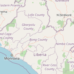
Map view of Kpelle National Forest

Use this park location map to pinpoint Kpelle National Forest in Liberia, understand its exact geographic position, and read its mapped placement within the surrounding landscape more clearly.

Pigeon | © OpenStreetMap contributors

Location context for Kpelle National Forest

Gbarpolu County
Park atlas

Trace the regional spread of tropical forests and conservation landscapes across West Africa, comparing areas similar to Kpelle National Forest.

Explore Nearby National Parks and Protected Areas Beyond Kpelle National Forest in Liberia
After exploring Kpelle National Forest, you can browse a curated selection of other national parks and protected areas situated within Liberia and the broader West African region. This allows for geographic comparison of similar tropical forest ecosystems and highlights the interconnected network of conservation landscapes across the Upper Guinean belt.
National parkEastern Province

Gola Rainforest National Park: Sierra Leone's Premier Rainforest Protected Area

Explore mapped boundaries and biodiversity in Eastern Province's vast tropical rainforest.

Gola Rainforest National Park is Sierra Leone's second national park and the largest intact rainforest landscape in the country, located in the Eastern Province. As part of the Upper Guinea Forest biodiversity hotspot, it is renowned for its exceptional wildlife, including western chimpanzees and pygmy hippopotamuses. This protected area's mapped extent covers over 71,000 hectares, contributing significantly to regional conservation and providing a vital natural resource for both wildlife and local communities.

Area
710.7 km²
Established
2010
IUCN
II
Relief
Lowland
Protected areaNimba County

Nimba National Forest: Protected Mountain Landscape & Bird Area in Nimba County

Explore mapped boundaries and regional geographic context.

Nimba National Forest, a protected area of approximately 187 square kilometers, is defined by its mountainous terrain in Nimba County, Liberia. Situated at the tri-border region with Guinea and Ivory Coast, this forest is recognized for its importance as a habitat for diverse bird species and its role in regional conservation efforts. Discover its mapped landscape, its position within the Nimba Range, and its ecological significance within West Africa's protected natural areas.

Area
187 km²
IUCN
VI
Access
Access unknown
Scope
Terrestrial
National parkNimba County

Gio National Forest National Park: A Protected Landscape in Nimba County

Mapping the geographic boundaries and regional context of Gio National Forest.

Gio National Forest National Park serves as a key protected area within Liberia's Nimba County. This destination facilitates detailed exploration of its specific geographic footprint and its contribution to the regional atlas. Users can investigate the park's natural landscape context, mapped terrain, and its role as a protected conservation zone. Understand where this significant natural area fits within the broader geographic framework of West Africa.

Area
327 km²
Established
1960
IUCN
IV
Relief
Upland
Protected areaNimba County

Gibi National Forest: Protected Tropical Forest in Nimba County, Liberia

Mapped landscape and regional geography of this key conservation area.

Gibi National Forest, a protected tropical forest spanning 607 square kilometers in Nimba County, Liberia, plays a crucial role in the preservation of the Upper Guinea forest ecosystem. Established in 1960, its landscape features tropical forest terrain near the mountainous Nimba Range. This protected area contributes significantly to regional conservation strategies, offering a vital habitat within a biodiversity hotspot that faces considerable pressure.

Area
607 km²
Established
1960
IUCN
VI
Climate
Tropical
National parkSinoe County

Sapo National Park: Explore Its Protected Landscape and Geographic Identity in Sinoe County

Discover mapped park boundaries and regional context.

Delve into the protected landscape of Sapo National Park, a key national park located in Sinoe County, Liberia. This page provides essential context for understanding its geographic setting, mapped park boundaries, and its significance as a protected natural area. It serves as a foundational entry for exploring Liberia's protected lands within the broader atlas, focusing on landscape identity and regional geographic features.

Area
1,804 km²
Established
1983
IUCN
II
Relief
Mixed relief
National parkKarene District

Outamba-Kilimi National Park: Sierra Leone National Park and Protected Landscape Atlas

Mapped natural terrain within Karene District.

Investigate Outamba-Kilimi National Park as a protected area, examining its geographic footprint and significance within Sierra Leone's natural landscapes. This detailed entry provides context on the park's mapped boundaries and its contribution to regional geography, serving as a key point for atlas-based exploration of conservation lands in the Karene District.

Area
1,109 km²
Established
1986
IUCN
II
Relief
Lowland
National parkFaranah Region

National Park of Upper Niger: Protected Landscape and Geographic Context in Faranah Region

Explore mapped boundaries and regional natural terrain.

National Park of Upper Niger is a key protected area within the Faranah Region of Guinea, providing a focal point for understanding regional geography and conservation landscapes. Its designation as a national park highlights its importance in the mapped atlas of protected territories. This page offers detailed insights into the park's geographic setting and its specific natural terrain, aiding exploration of Guinea's protected lands.

Area
6,000 km²
Established
1997
IUCN
II
Relief
Mixed relief
National parkIvory Coast

Mont Péko National Park: Ivory Coast National Park with Mapped Boundaries

Explore its protected landscape and regional geography.

Delve into Mont Péko National Park, a designated national park within Ivory Coast, to understand its unique protected landscape. This entry facilitates detailed atlas exploration, focusing on its geographic placement, mapped boundaries, and contribution to the regional natural terrain. Discover the essence of this protected area through its mapped geography and landscape identity.

Area
340 km²
Established
1968
IUCN
II
Relief
Mountain

Common questions about visiting, size, designation, and location context for Kpelle National Forest

Kpelle National Forest FAQs for park facts, access, geography, and protected area context
Find quick answers about Kpelle National Forest, including protected-area facts, park geography, trail and visitor context, and how the park fits into its surrounding country and regional landscape.
MoriAtlas Explorer

Continue Your Protected Areas Search Across the Global Atlas

Deepen your exploration by continuing the structured search for national parks and protected areas worldwide. Utilize the comprehensive filtering capabilities to compare different conservation landscapes and refine your understanding of global park geography. Discover more about the distribution and characteristics of protected natural areas.

Global natural geography